April 18, 2024
Low pressure tracking across south-central Illinois brought a round of strong to severe thunderstorms to locations along and south of the I-72 corridor during the late afternoon and evening of April 18th. The hardest hit area stretched from the east side of Springfield northeastward to near Clinton where numerous reports of wind damage were received. Three tornadoes touched down in this corridor...including an EF-1 tornado in Warrensburg (Macon County), an EF-1 tornado west of Argenta (Macon County), and an EF-0 tornado in Latham (Logan County). Additional tornadoes and very large hail occurred further southwest in and around the Saint Louis metro area.
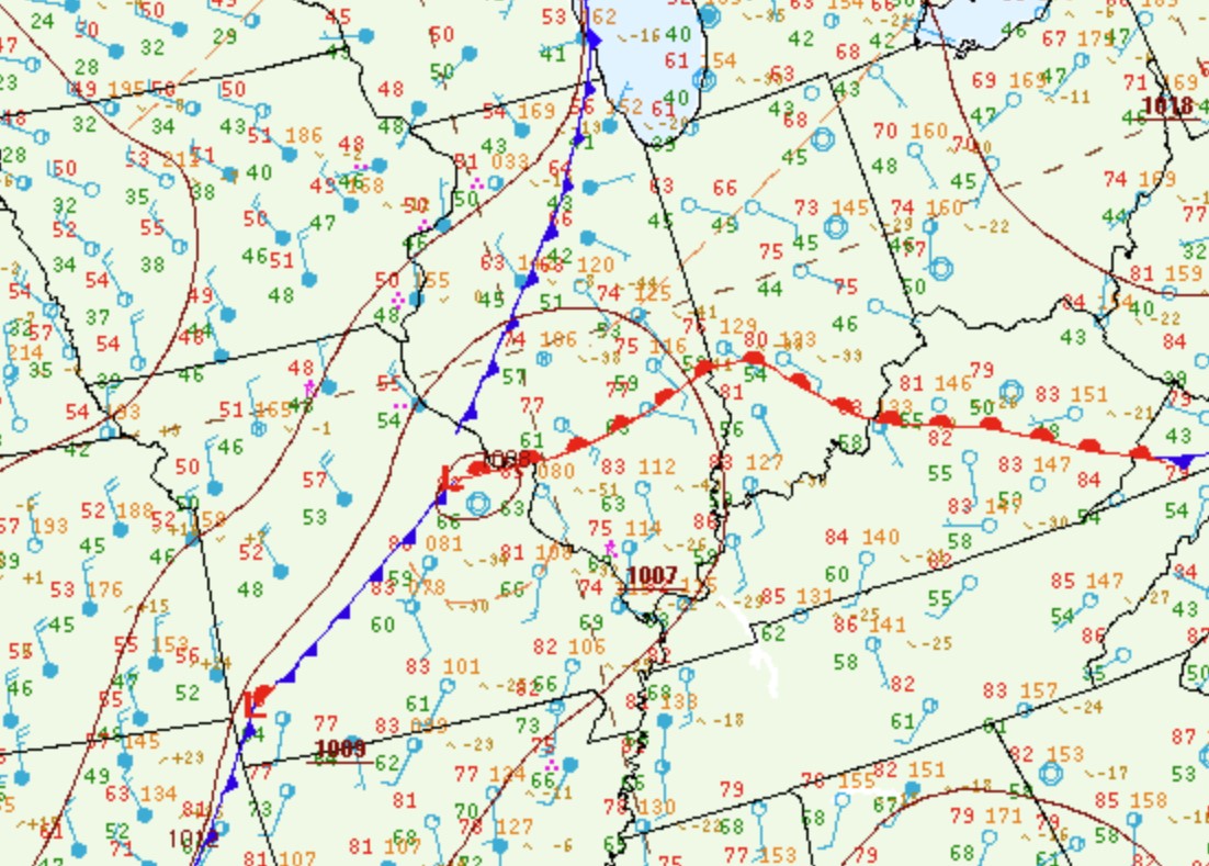
Surface analysis from the afternoon of April 18th showed a 1008mb low centered near Saint Louis with a warm front extending northeastward to Terre Haute, Indiana. Temperatures were in the upper 60s and lower 70s north of the front across much of central Illinois, but warmed into the upper 70s and lower 80s to the south. With southerly winds bringing moisture northward from the Gulf of America, dewpoints climbed into the middle 60s across southeastern Missouri into southern Illinois, which resulted in Surface Based Convective Available Potential Energy (SBCAPE) values of 1500-2000J/kg.
SURFACE WEATHER MAP 4PM CDT APRIL 18
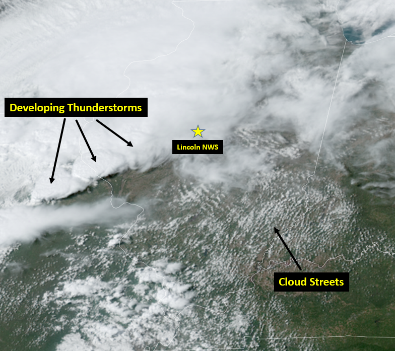
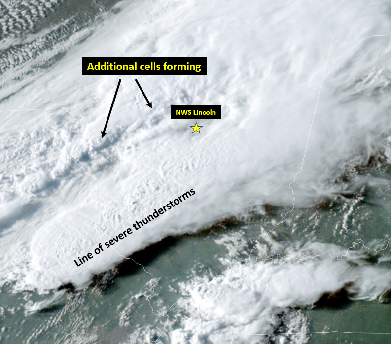
Visible satellite imagery from 4pm showed the development of cloud streets within the warm sector across western Kentucky into southern Illinois. This is indicative of a destabilizing boundary layer airmass that is still "capped" by a layer of warmer air aloft. Further west where the cap had eroded in advance of a vigorous upper disturbance, thunderstorms rapidly developed along the warm front across west-central Illinois into Missouri.
VISIBLE SATELLITE IMAGERY 4PM CDT APRIL 18
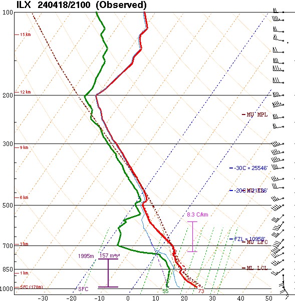
The primary forecast question for the afternoon and evening was exactly how far north the warm front would lift before the low tracked across the area. NWS Lincoln conducted a special 21z (4pm) upper air balloon launch in order to better assess the evolving airmass. Since Lincoln was just north of the main boundary during the balloon launch, the afternoon sounding revealed only meager instability with SBCAPEs of less than 500J/kg. However, steep lapse rates and surface-3km shear values of 40kt raised concern for rotation within any storms that developed this far north. Note surface winds from the southeast at 15kt veering to the southwest and increasing to 40kt at 3km aloft in the image below.
21Z/4PM LINCOLN UPPER AIR SOUNDING
By 6pm, a line of severe thunderstorms had developed from south of Springfield southwestward into the Saint Louis area. Numerous reports of damaging wind gusts in excess of 60mph, hail larger than golf balls, and even tornadoes were received. Meanwhile further northwest, additional thunderstorm cells formed along an advancing cold front just east of the Illinois River.
VISIBLE SATELLITE IMAGERY 6PM CDT APRIL 18
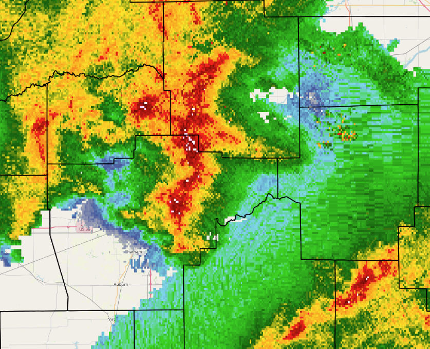
One of the northwestern cells quickly became severe as it tracked near the triple point just north of the low pressure center. This particular cell produced 60-70mph winds and numerous reports of wind damage from eastern Sangamon County northeastward into northern Macon and southern DeWitt counties. As boundary layer vorticity was enhanced in the vicinity of several notches along the leading edge of the storm, 3 tornado touchdowns occurred. At 7:20PM CDT, an EF-0 tornado caused minor tree and structural damage in Latham in southeast Logan County. Shortly afterwards, an EF-1 tornado developed southeast of Latham and crossed into Macon County where it damaged several homes in Warrensburg. Another EF-1 tornado touched down at 7:37PM CDT 2 miles north of Forsyth in Macon County, then tracked eastward damaging trees, grain bins, and power poles before dissipating west of Argenta.
RADAR IMAGERY 7:05PM CDT APRIL 18
The tornado-producing thunderstorm weakened as it tracked further northeastward, producing minor wind damage near Champaign before dissipating further. Meanwhile the line of severe storms near Saint Louis swept eastward into the far southern portion of the NWS Lincoln County Warning Area (CWA), causing scattered wind damage south of I-70. The storms then exited into Indiana by mid-evening.
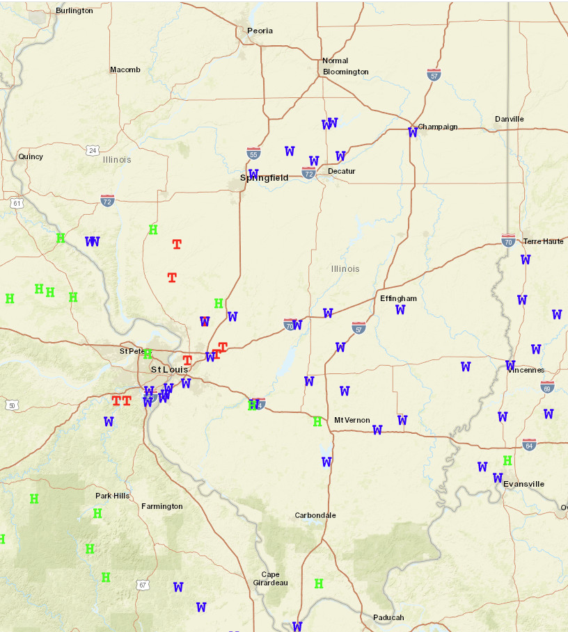
SEVERE WEATHER REPORTS FOR APRIL 18