June 1-2, 2010
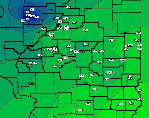
A long line of thunderstorms known as a "bow-echo" impacted central Illinois during the night of June 1st into the early morning of June 2nd. The storms brought gusty winds, small hail, and numerous lightning strikes. Winds associated with the storms were generally between 40 and 50 mph...however a few isolated locations experienced gusts as high as 80 to 90 mph. Rainfall averaged between one half and one inch across the area, but was substantially heavier across parts of Knox, Stark, and Peoria counties, where one to three inches fell.
The pre-storm environment across central Illinois was quite warm and humid during the afternoon of June 1st, with temperatures well into the 80s and dewpoints in the middle to upper 60s. Upper air balloons launched at NWS Lincoln, IL and NWS Quad Cities, IL indicated moderately high CAPE values ranging from 1500 to 2500J/kg. CAPE is a measure of the potential energy available in the atmosphere. In general, the higher the value of CAPE, the greater the potential for storms to develop vigorous updrafts, large hail, and gusty winds. The soundings also showed an elevated warm layer at around 6000 to 7000ft aloft.
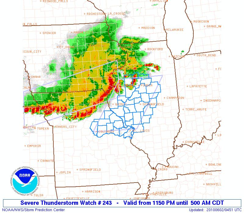
Thunderstorms initiated along a nearly stationary frontal boundary extending from the Upper Midwest into the Plains during the afternoon of June 1st. Strong to severe storms organized across eastern Nebraska and western Iowa, then began tracking eastward. As the evening progressed, the storms began to turn more southeasterly toward the better instability across central Illinois. As they continued southeastward, they began to accelerate and soon took on a classic bow shape on radar, indicative of very strong winds. Shortly before 12 AM, the Storm Prediction Center (SPC) issued a Severe Thunderstorm Watch for all of central Illinois along and west of I-55.
Below is a radar image from 11:50 PM, depicting the newly issued watch. Note the red bow-shaped echo across far southeast Iowa approaching the Mississippi River.
Here is another radar image from shortly before 2AM when the Storm Prediction Center (SPC) issued a second Severe Thunderstorm Watch for the remainder of central and southeast Illinois:
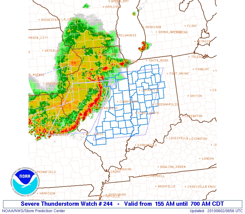
The storms then raced across the area between midnight and 4 AM, producing gusty winds and copious amounts of lightning. Despite the rather impressive looking bow echo that swept all the way into Indiana, surface wind reports were generally below severe limits. The stabilizing low-level environment during that time of night likely prevented much stronger winds aloft from making it down to the surface. The evening upper air soundings had hinted at this stabilization, showing the slightly warmer air at 6000 to 7000ft. As the storms moved into the Illinois River Valley, a few weak circulations developed along the leading edge. These circulations helped push the stronger winds through the more stable surface layer to the ground, creating isolated areas of enhanced wind damage.
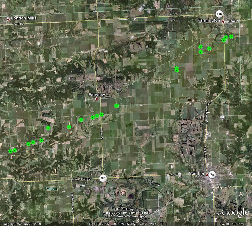
One circulation caused 80 to 90 mph winds across parts of Fulton County, from near Fairview northeastward to just south of Farmington. Several machine sheds and outbuildings were destroyed and numerous trees and powerlines were snapped or blown down along this path. Other circulations produced enhanced wind gusts and damage in Tazewell County, south and east of Mackinaw and northwest of Armington. Yet another weak circulation brought 60 mph winds to parts of Springfield, resulting in damage to a large storage shed. Below is a detailed map of the damage path observed across Fulton County. Each point represents damage noted by NWS staff during a storm survey conducted on June 3rd.
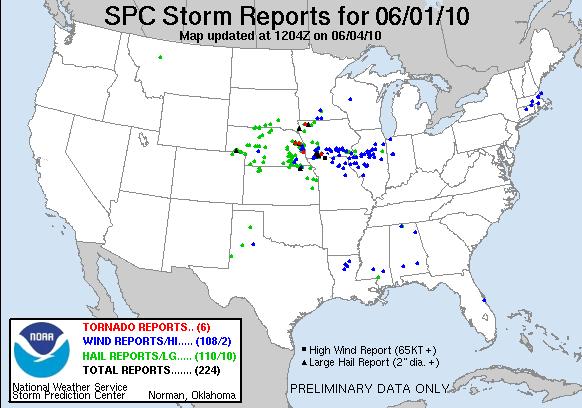
Below is a map of storm reports received from across the entire country from June 1-2, 2010. Note most of the damaging wind reports occurred across west-central Illinois before the storms gradually weakened as they tracked into east-central and southeast parts of the state.
Finally here is more detailed look at rainfall and storm reports gathered locally via the NWS SWOP network.
|
City |
County |
Rainfall |
Hail |
Wind Gust |
|
Galesburg |
Knox |
2.75 |
|
|
|
Knoxville |
Knox |
2.60 |
|
|
|
Gilson |
Knox |
2.43 |
|
|
|
Galesburg North |
Knox |
2.17 |
|
|
|
Wataga |
Knox |
2.17 |
|
|
|
Dunlap 2SE |
Peoria |
1.72 |
|
|
|
Abingdon 1N |
Knox |
1.55 |
1/4" |
60 mph |
|
Philadelphia 2S |
Cass |
1.48 |
1/4" |
60 mph |
|
Clinton |
DeWitt |
1.20 |
||
|
Avon 5W |
Warren |
1.09 |
|
|
|
Jacksonville West |
Morgan |
1.08 |
|
|
|
Loxa |
Coles |
1.08 |
|
|
|
Mt. Pulaski |
Logan |
1.00 |
|
|
|
Henry |
Marshall |
0.95 |
|
|
|
Germantown Hills 2N |
Woodford |
0.95 |
|
|
|
Pekin |
Tazewell |
0.85 |
|
|
|
Chestnut 2S |
Logan |
0.85 |
|
51 mph |
|
Oakland 7N |
Douglas |
0.84 |
|
|
|
Canton |
Fulton |
0.82 |
|
|
|
Neoga |
Cumberland |
0.80 |
|
|
|
Petersburg |
Menard |
0.78 |
|
35 mph |
|
Jacksonville |
Morgan |
0.77 |
|
|
|
Lovington |
Moultrie |
0.76 |
|
|
|
Pana |
Christian |
0.74 |
|
|
|
Lincoln NWS |
Logan |
0.71 |
|
|
|
Mahomet |
Champaign |
0.70 |
|
43 mph |
|
Chatham |
Sangamon |
0.69 |
|
|
|
Monticello |
Piatt |
0.66 |
|
|
|
Cisco 2NE |
Piatt |
0.65 |
|
|
|
Eureka |
Woodford |
0.64 |
1/4" |
40 mph |
|
Petersburg 8E |
Menard |
0.63 |
|
44 mph |
|
Mattoon |
Coles |
0.63 |
|
|
|
Altamont |
Effingham |
0.63 |
|
|
|
Danville |
Vermilion |
0.63 |
|
|
|
Springfield (COOP) |
Sangamon |
0.62 |
|
|
|
Peoria |
Peoria |
0.60 |
1/4" |
|
|
Manito 1S |
Mason |
0.60 |
|
|
|
Tuscola |
Douglas |
0.59 |
|
|
|
Martinsville 2NE |
Clark |
0.59 |
|
|
|
Mackinaw 1N |
Tazewell |
0.59 |
|
|
|
Rossville |
Vermilion |
0.58 |
|
|
|
Hoopeston |
Vermilion |
0.58 |
|
|
|
Westville |
Vermilion |
0.57 |
|
|
|
Manito |
Mason |
0.55 |
|
45 mph |
|
Shelbyville |
Shelby |
0.54 |
|
|
|
Morton |
Tazewell |
0.52 |
|
|
|
Alma |
Marion |
0.52 |
|
|
|
Bloomington |
McLean |
0.52 |
||
|
Riverton |
Sangamon |
0.51 |
|
|
|
Ogden |
Champaign |
0.51 |
|
40 mph |
|
Fithian |
Vermilion |
0.48 |
|
|
|
Bismarck 3W |
Vermilion |
0.47 |
|
42 mph |
|
Greenview 3SE |
Menard |
0.46 |
|
|
|
Homer 2N |
Champaign |
0.43 |
|
|
|
Martinsville |
Clark |
0.40 |
|
|
|
Trimble 1E |
Crawford |
0.28 |
|
|
|
Sumner |
Lawrence |
0.22 |
|
|
|
Centralia |
Marion |
0.17 |
|
|
|
Olney 2S |
Richland |
0.15 |
|
|
|
Birds 2E |
Lawrence |
0.06 |
|
|
|
Mackinaw 2E |
Tazewell |
|
|
60 mph |
|
Normal |
McLean |
|
|
45 mph |

