June 7-8, 2015
Several rounds of thunderstorms impacted central Illinois on June 7th and 8th, producing numerous reports of wind damage, flash flooding, and 2 confirmed tornado touchdowns. Rainfall totals were quite impressive as well, with a few locations picking up as much as 4 to 6 inches.
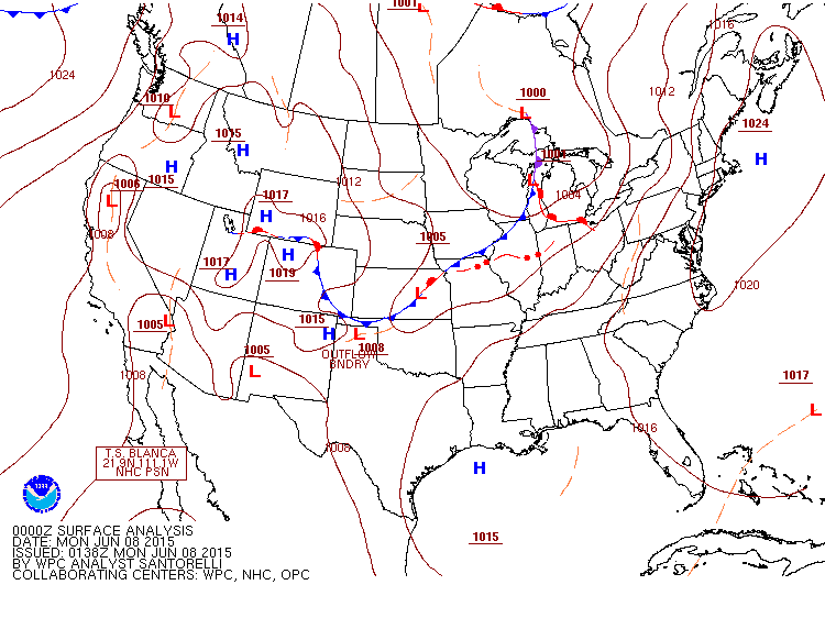
An approaching cold front triggered a cluster of thunderstorms across Minnesota into the northern and central sections of Iowa during the evening of June 6th, which then tracked eastward across the Mississippi River by the early morning of June 7th. The storms were non-severe as they spread across north-central Illinois during the morning hours: however, they produced locally heavy rainfall amounts of 1 to 1.50 inches in a short-period of time mainly along and north of a Rushville...to Bloomington...to Hoopeston line. An outflow boundary produced by the storms dropped southward to near the I-72 corridor, then surged back northward during the afternoon as strong southwesterly winds transported very warm and humid air into the region. With temperatures soaring into the upper 80s and lower 90s and dewpoints reaching the lower 70s, Convective Available Potential Energy (CAPE) values peaked over 3000J/kg by afternoon. A weak short-wave trough tracking eastward out of Missouri provided a slight increase to winds aloft, which helped enhance low-level wind shear across the area as well. Below is a map depicting the weather by the evening of June 7th. Note the cold front pushing into northwest Illinois.
As the cold front began to approach from the northwest, additional thunderstorms began to rapidly develop along a Chicago...to Peoria...to Quincy line by mid to late afternoon in this highly unstable and modestly sheared environment. Some of the storms produced hail as large as golf balls near Glasford in Peoria County and winds in the 60 to 70mph range as they tracked eastward across Peoria, Tazewell, and Woodford counties. Numerous trees and tree limbs were blown down across this area, with the city of Peoria being particularly hard hit.
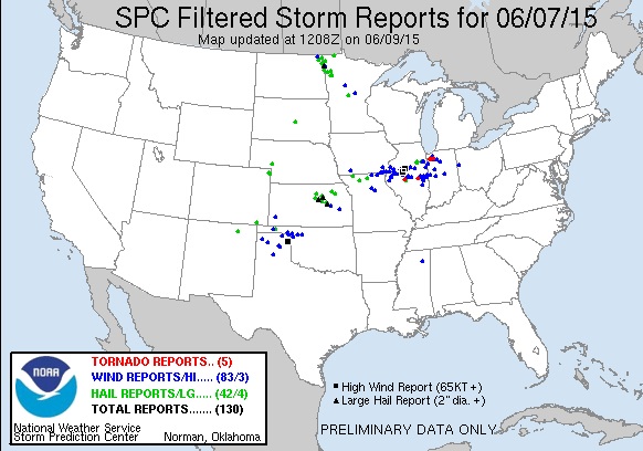
The storms then congealed into a west-east oriented line from near Macomb eastward to northern Champaign and Vermilion counties. With training cells repeatedly impacting some of the same locations that experienced heavy rainfall during the morning, flash flooding quickly became a concern. Water flowed across Highway 136 near the Logan/McLean County line, where an estimated 4 to 5 inches of rain occurred. As the event progressed, the storms eventually developed an impressive cold pool behind them, which began pushing them southeastward toward the I-72 corridor by mid-evening. Periodic wind damage reports continued to be received as the storms occasionally exhibited bowing segments on radar. Two brief tornado touchdowns occurred within the line of storms. One touched down about 8 miles east of Petersburg in Menard County, where a SWOP observer recorded an 87 mph wind gust on his anemometer and reported damage to a barn on his property. A second tornado touched down in rural Piatt County, then tracked into Champaign County where it damaged a barn and several trees southwest of Seymour. As daytime instability weakend well after sunset, severe weather reports dropped off by late evening. However, very heavy rainfall continued to be an issue through the night as the convection dropped into southeast Illinois. By the time the storms exited the region by the morning of June 8th, flash flooding was ongoing across portions of Champaign, Vermilion, Effingham, and Clay counties. The heaviest rain fell from far eastern Champaign County across central Vermilion County, where totals of 4 to 6 inches were common. A SWOP observer in Ogden on the Champaign/Vermilion County line measured 5.04 inches and reported quite a bit of flash flooding in town. Further south, Effingham and Clay counties received 3 to 4 inches of rain, which caused flash flooding of many rural and low-lying locations as well. Below is a map of all the severe weather reports across the U.S. from June 7th.