June 11, 2026
A strong storm system interacted with a highly unstable and sheared environment to produce a significant severe weather outbreak across central Illinois during the late afternoon and evening of June 11th. Scattered supercell thunderstorms initially developed west of the I-55 corridor along a pre-frontal trough during the afternoon. One of these storms produced an EF-3 tornado that impacted portions of Woodford and Marshall counties and dropped golf ball-sized hail (1.75" diameter). Additional cells rapidly developed further west across southeastern Iowa into northern Missouri ahead of an advancing cold front. These storms congealed into a line and pushed eastward into central Illinois during the evening. Widespread damaging wind gusts of 60-70mph occurred with the line along and north of the I-72 corridor. After storm surveys were completed, it was discovered an additional 7 tornadoes were embedded within the line...creating pockets of enhanced damage.
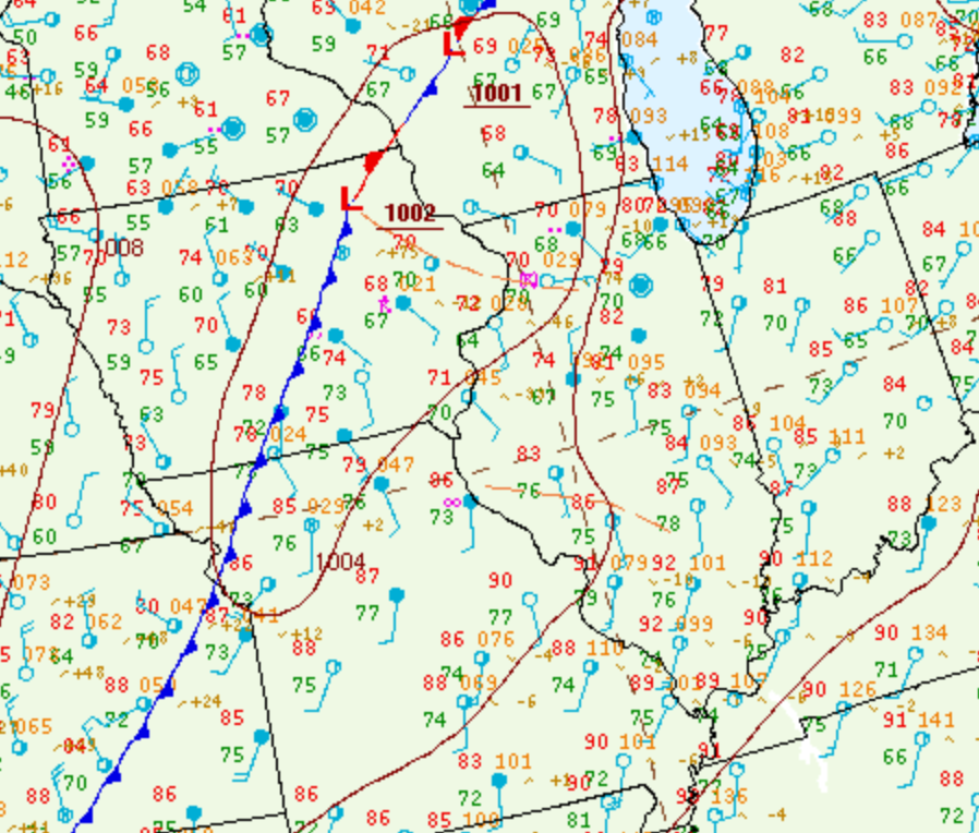
Surface analysis from the afternoon of June 11th revealed a warm and very humid airmass across central Illinois with temperatures well into the 80s and dewpoints in the middle to upper 70s. A cold front stretched from western Wisconsin southwestward to near Kansas City, while an outflow boundary from early morning convection was evident from southeastern Iowa into north-central Illinois.
SURFACE MAP 1PM CDT JUNE 11, 2026
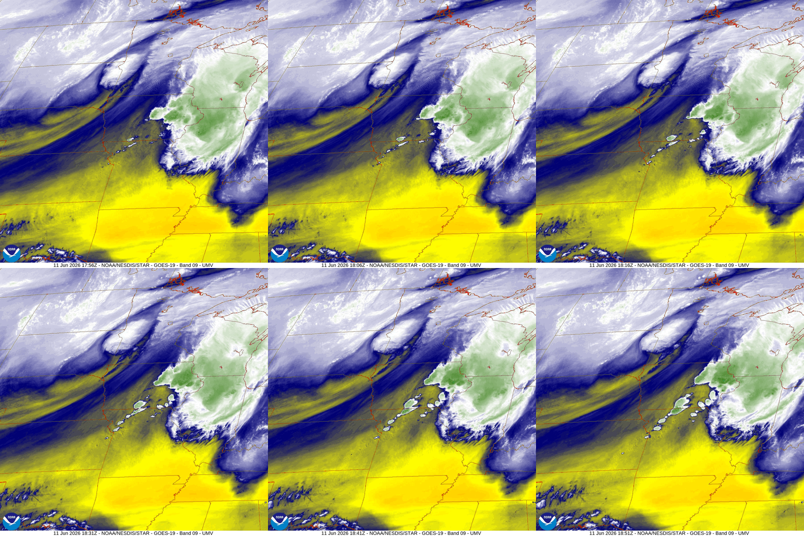
A vigorous short-wave trough spinning over the Northern Plains was tracking eastward and providing increased synoptic lift over the cold front. On the water vapor imagery below, note the spin over eastern South Dakota into western Minnesota.
WATER VAPOR IMAGERY 1:51PM CDT JUNE 11, 2026
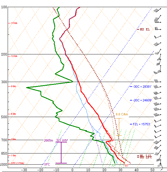
NWS Lincoln conducted two special upper air balloon launches during the afternoon of June 11th in support of the impending severe weather. The second sounding at 4pm showed extreme instability with Surface Based Convective Available Potential Energy (SBCAPE) in excess of 5000J/kg. Deep-layer shear was on the increase ahead of the approaching short-wave trough as shown by 0-6km values of 46kt. At the same time, shear in the lowest 0-1km layer was a robust 25kt. The wind profile showed both directional and speed shear as 10-15kt southeasterly surface winds veered to southwesterly and increased to 50kt at 10,000ft aloft.
NWS LINCOLN UPPER AIR SOUNDING 4PM CDT JUNE 11, 2026
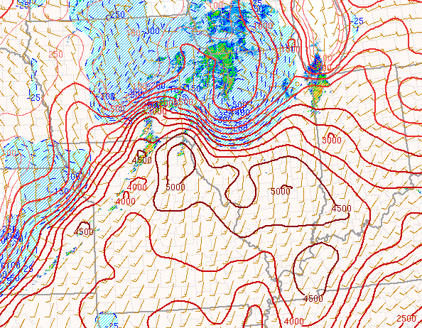
2PM CDT mesoanalysis from the Storm Prediction Center (SPC) highlighted the reservoir of SBCAPES in excess of 5000J/kg across central and southern Illinois, while maintaining a much more stable airmass north of the remnant outflow boundary from Burlington, Iowa to Lacon, Illinois (left image below). Meanwhile low-level shear was greatest near the boundary as evidenced by 0-km values greater than 25kt along and west of the Illinois River (right image).
2PM CDT SURFACE BASED CAPE 2PM CDT 0-1KM SHEAR
 |
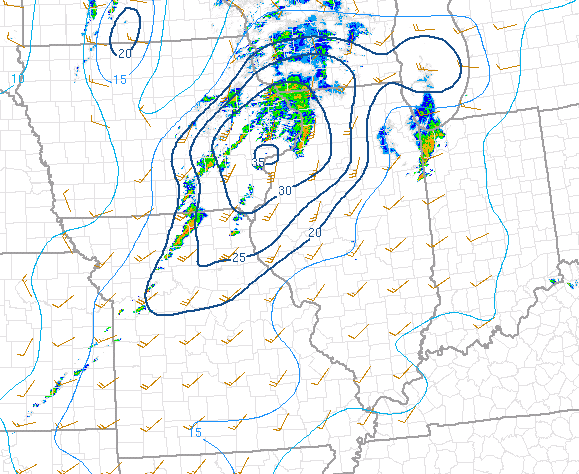 |
At this time, there was a growing concern for potentially strong tornadoes where the strongest instability/shear co-existed during the late afternoon into the early evening. The 2PM CDT Significant Tornado Parameter (STP) was subsequently maximized along the southern periphery of the outflow boundary from southeastern Iowa to near Lincoln. RAP forecasts consistently showed the STP maxima shifting northward as the outflow boundary lifted toward I-80 later in the day. This provided growing confidence in the initial strong tornado forecast highlighting locations along and north of a Macomb to Bloomington line.
2PM CDT SIGNIFICANT TORNADO PARAMETER (STP)

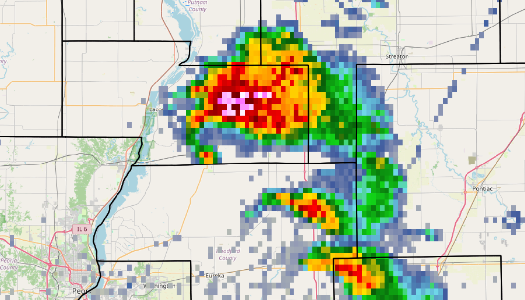
By late afternoon, the lingering outflow boundary had mixed northward to near a Galesburg to Pontiac line...while a pre-frontal trough had pushed into the Illinois River Valley from the west. A few small supercell thunderstorms developed ahead of the trough...and as they tracked northeastward toward the outflow boundary where the low-level shear was maximized, began strongly rotating. As a cell merger took place, a tornado rapidly developed west of Low Point in northwestern Woodford County, then tracked northeastward into Marshall County. The radar image from 5:08PM CDT showed a prominent hook echo, as well as a high reflectivity core indicative of large hail with the cell.
5:08PM CDT RADAR IMAGERY
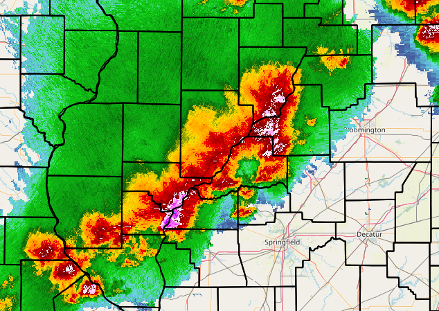
The initial cells lifted into northeastern Illinois by early evening: however, additional thunderstorms quickly erupted further west closer to the approaching cold front. Strong winds, hail, and a few tornadoes were initially reported with these storms in parts of the Illinois River Valley, but they quickly organized into a linear structure as they tracked further eastward.
6:10PM CDT RADAR IMAGERY
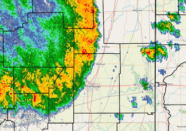
For the remainder of the event, a Quasi-Linear Convective System (QLCS or "squall line") advanced eastward across central Illinois...resulting in widespread damaging wind gusts of 60-70mph mainly along and north of the I-72 corridor. Numerous kinks and notches formed along the leading edge of the line, resulting in potential spin-up tornadoes. In addition, isolated supercells developed ahead of the line...also posing a tornado risk. In the 7:19PM CDT radar imagery below, note the "wavy" look to the leading edge of the storms across Ford and Champaign counties and the isolated supercell in northeastern Vermilion County near Hoopeston.
7:19PM CDT RADAR IMAGERY
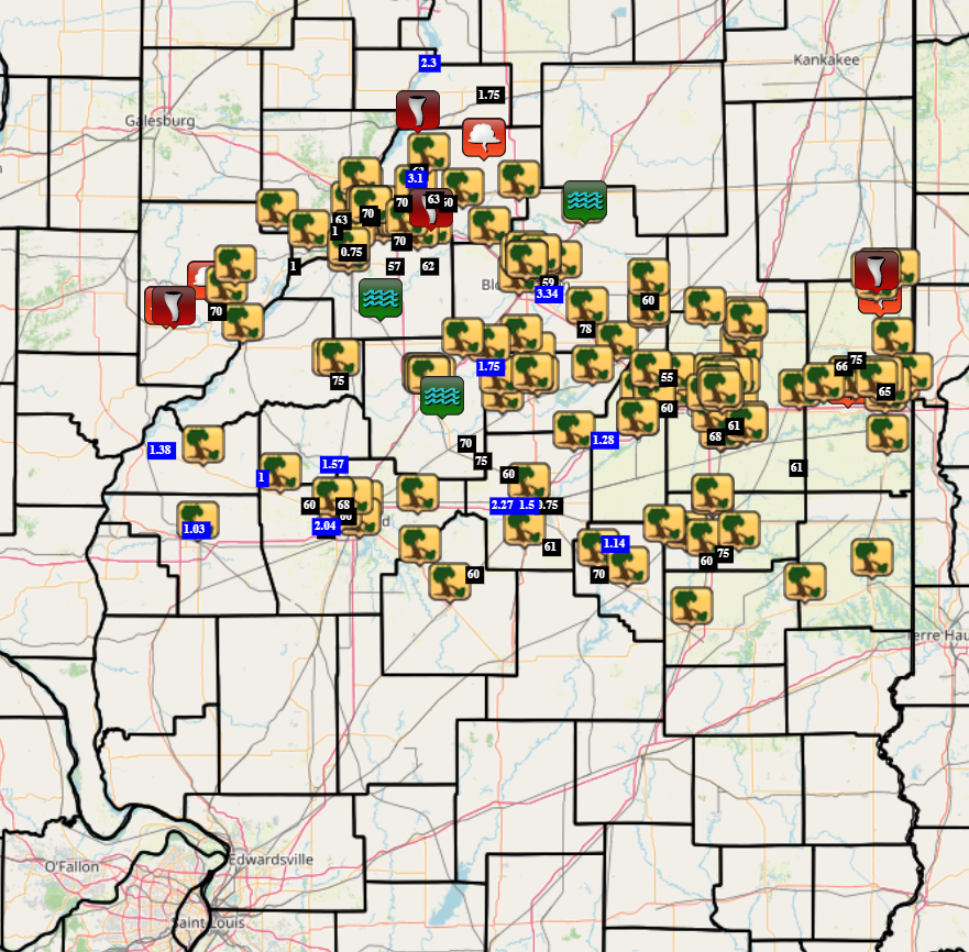
The leading edge of the squall line raced into Indiana after 8pm, while the trailing line gradually sank southward toward I-70 and weakened. Over 200 severe weather reports were received during this significant weather event. The vast majority were wind damage: however, there were also a few instances of large hail and flash flooding. NWS Lincoln is currently conducting storm damage surveys in a few locations to determine the track and strength of tornadoes that occurred. Results will be posted as the the surveys are completed and all the data is analyzed over the next couple of days.
JUNE 11, 2026 SEVERE WEATHER REPORTS



 Follow us on X
 Follow us on Facebook
 Follow us on YouTube
 ILX RSS Feed