June 17, 2026
Several rounds of significant convection impacted central Illinois on June 17th, 2026. Clusters of thunderstorms initially formed on the nose of a strong low-level jet streak across Iowa during the pre-dawn hours, then tracked southeastward along a warm frontal boundary into central Illinois through midday. As the clusters organized into lines, 70-90mph wind gusts in Iowa prompted the issuance of a downstream Tornado Watch north of the I-70 corridor. With an unfavorably dry/stable boundary layer initially in place, only scattered damaging wind gusts were reported in north-central Illinois...with the most concentrated corridor of 60-70mph winds focused along a Galesburg...to Peoria...to Chenoa line.
Thunderstorms re-developed along a remnant outflow boundary from the morning convection by mid to late afternoon...with the most intense cells materializing along and south of a Springfield to Paris line where several tornadoes occurred and hail larger than baseballs (3" diameter) was reported across portions of Moultrie, Douglas, and Coles counties.
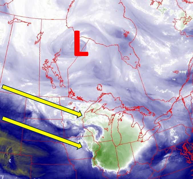
Mid-morning water vapor imagery showed an unseasonably deep upper low centered over northern portions of Manitoba and Ontario (indicated by the red L on the image below)...while a vigorous polar jet stream was noted on the S/SW periphery of the low (yellow arrows). This type of synoptic pattern is more typical of April rather than June and resulted in unusually strong mid/upper level winds across the Northern Plains into the Midwest. In addition, note the series of curls embedded within the jet stream from North Dakota to Wisconsin. These short-wave troughs were providing additional synoptic lift as they tracked southeastward toward the southern Great Lakes.
WATER VAPOR IMAGERY 1030AM CDT JUNE 17, 2026
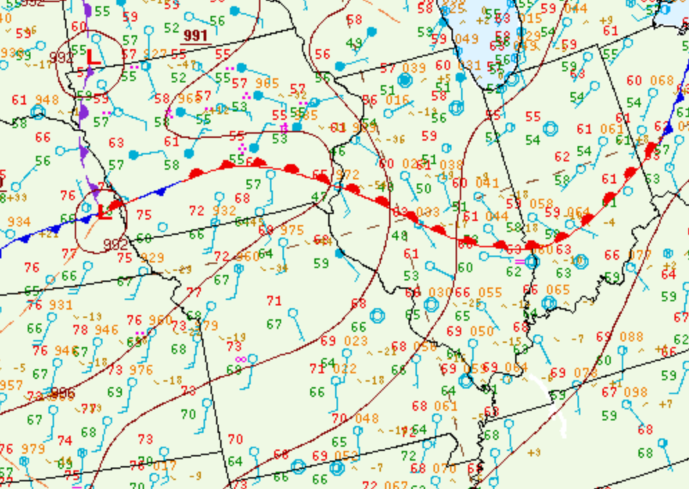
7AM CDT surface analysis revealed a well-defined warm front extending from southern Iowa to southern Indiana. Dewpoints to the north of the boundary were only in the upper 40s and lower 50s across much of central Illinois, while much richer moisture characterized by dewpoints in the middle to upper 60s was noted south of the front across Kansas and Missouri.
SURFACE MAP 7AM CDT JUNE 17, 2026
Mesoanalysis from the Storm Prediction Center (SPC) showed the stable boundary layer across central Illinois and highlighted the much more unstable environment south of the warm front where Surface Based Convective Available Potential Energy (SBCAPE) values ranged from 1500-2500J/kg across Kansas into western Missouri.
SURFACE BASED CAPE 9AM CDT JUNE 17, 2026
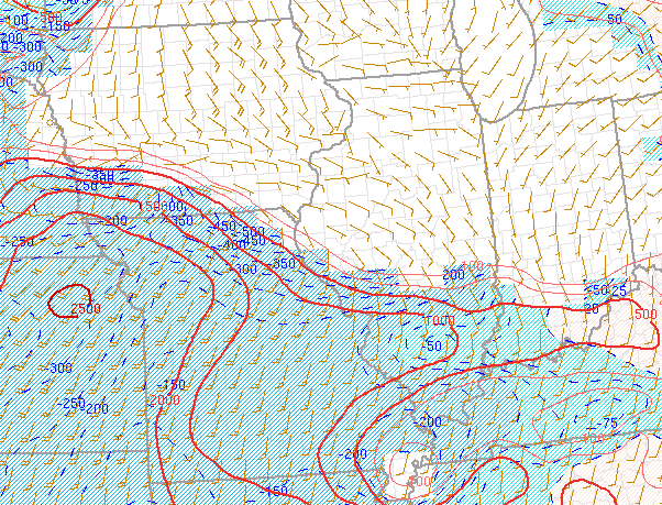
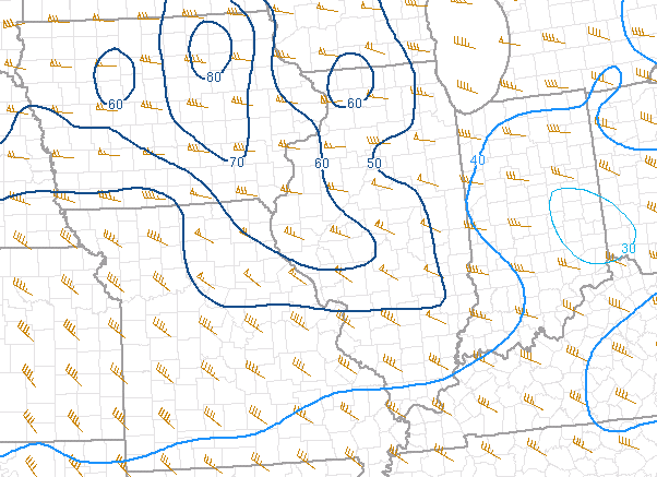
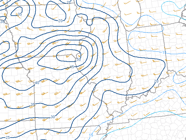
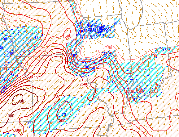
Given the very strong jet stream winds aloft, impressive deep-layer shear values of 50-70kt were evident (left image below). In addition, low-level 0-1km shear was maximized at 45-50kt near the warm front across northern Missouri and far southern Iowa (right image).
0-6KM SHEAR 9AM CDT JUNE 17, 2026 0-1KM SHEAR 9AM CDT JUNE 17, 2026
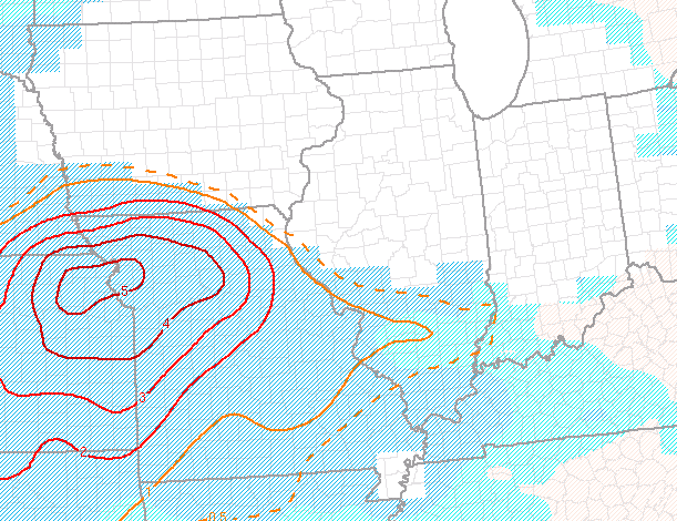
The 9am CDT Significant Tornado Parameter (STP) was maximized in the Kansas City area eastward into northern Missouri, while remaining below 0.5 across central Illinois.
SIGNIFICANT TORANDO PARAMETER 9AM CDT JUNE 17, 2026
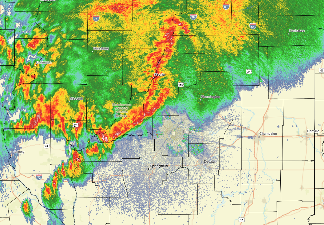
As anticipated, thunderstorms initially developed on the nose of a 50-60kt low-level jet streak along the warm front across central and southern Iowa during the pre-dawn hours. Clusters of storms evolved into a linear structure, then began accelerating southeastward along the warm front after daybreak. With favorable inflow from the low-level jet supporting the convection, numerous wind gusts of 70-90mph were observed across eastern Iowa. As the line pushed eastward into the drier and more stable airmass across central Illinois, it gradually lost momentum: however, a corridor of 60-70mph gusts caused sporadic wind damage along a Galesburg...to Peoria....to Chenoa line. Further south along the trailing line, winds were considerably lighter, but still downed tree branches in a few locations. Note the well-defined squall line on the 9:31am CDT radar imagery below.
RADAR IMAGERY 9:31AM CDT JUNE 17, 2026
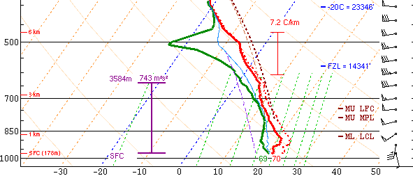
The early morning squall line pushed the warm front southward to a Hannibal, Missouri to Salem, Illinois line toward midday. At the same time, the strong low-level jet streak that had been oriented from the Texas panhandle northeastward to Iowa shifted eastward and directed its elevated moisture/instability inflow over the effective frontal boundary into central Illinois. This resulted in waves of mainly elevated thunderstorms with copious rainfall, but little in the way of wind or hail from late morning into the early afternoon. The showers and thunderstorms gradually tapered off and shifted further east, leading to a brief lull in precipitation by mid-afternoon. Given the break in the storms, NWS Lincoln launched a special weather balloon in order to sample the storm environment. While the 3pm CDT sounding continued to show a stable boundary layer north of the warm front/outflow boundary with SBCAPEs of just 366J/kg, a large degree of both speed and directional shear was observed. Southeasterly surface winds of around 10kt veer to westerly and increased to 70-75kt at 12,000ft aloft. This created 0-6km bulk shear of 64kt and 0-1km shear of 47kt. Given strong southwesterly flow in the warm sector across Missouri and southern Illinois, the frontal boundary was expected to lift back northward later in the afternoon into the early evening. With extreme shear and an anticipated uptick in instability, concern was growing that supercell thunderstorms would rapidly initiate along the front. Thanks to a feed of warm/moist air from the south and plenty of shear to produce rotating updrafts, all severe hazards were expected with the storms...including tornadoes, damaging wind gusts in excess of 70mph, and hail larger that golf balls.
NWS LINCOLN UPPER AIR SOUNDING 3PM CDT JUNE 17, 2026
2pm mesoanalysis from SPC showed a markedly destabilizing airmass within the warm sector across Missouri where SBCAPEs had increased into the 3000-4000J/kg range. While much of central Illinois was still relatively stable, the outflow boundary had edged northward...allowing the more unstable airmass to approach the I-72 corridor from the south.
SURFACE BASED CAPE 2PM CDT JUNE 17, 2026
Subsequently, the Significant Tornado Parameter (STP) increased near the slowly moving boundary, with maximum values of 3-4 from near Springfield and Decatur southeastward toward Salem.
SIGNIFICANT TORNADO PARAMETER 2PM CDT JUNE 17, 2026
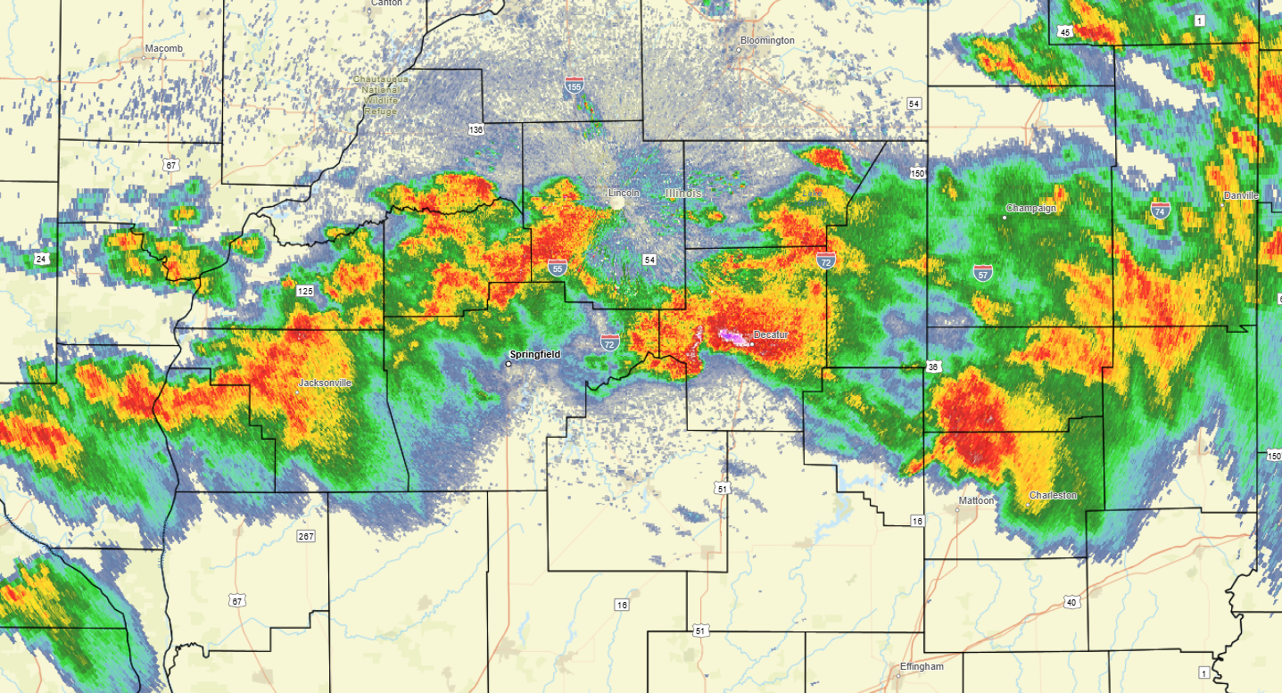
Shortly after 3pm, thunderstorms began developing north of the outflow boundary from far northern Missouri eastward toward Bloomington-Normal. As the atmosphere destabilized and the broken line of storms sagged further southeastward toward the higher low-level shear near the boundary, the storms quickly began rotating...prompting the issuance of numerous severe thunderstorm and tornado warnings. Note the developing hook echoes on the 4pm radar imagery below...particularly with the cells over Cass, Menard, and northeastern Macon County.
RADAR IMAGERY 4PM CDT JUNE 17, 2026
Storm structure continued to improve as the line pushed south of the I-72 corridor where low-level shear was strongest and the Significant Tornado Parameter (STP) was maximized. In the 5:51pm radar imagery, note the prominent supercell over Macon County. The high reflectivity core (pink color) resulted in golf ball-sized hail (1.75" diameter) in parts of Decatur and quarter-sized hail (1.00" diameter) at the Decatur Airport. The airport also logged a 78mph wind gust at around 6pm CDT.
RADAR IMAGERY 5:51PM CDT JUNE 17, 2026
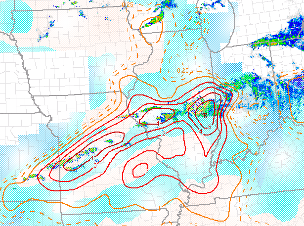
By 6pm CDT, maximum values of the Significant Tornado Parameter (STP) had shifted into east-central Illinois along and south of the I-70 corridor and had increased to 4-6. This gave further confidence for the potential of strong tornadoes over the next few hours.
SIGNIFICANT TORNADO PARAMETER 6PM CDT JUNE 17, 2026
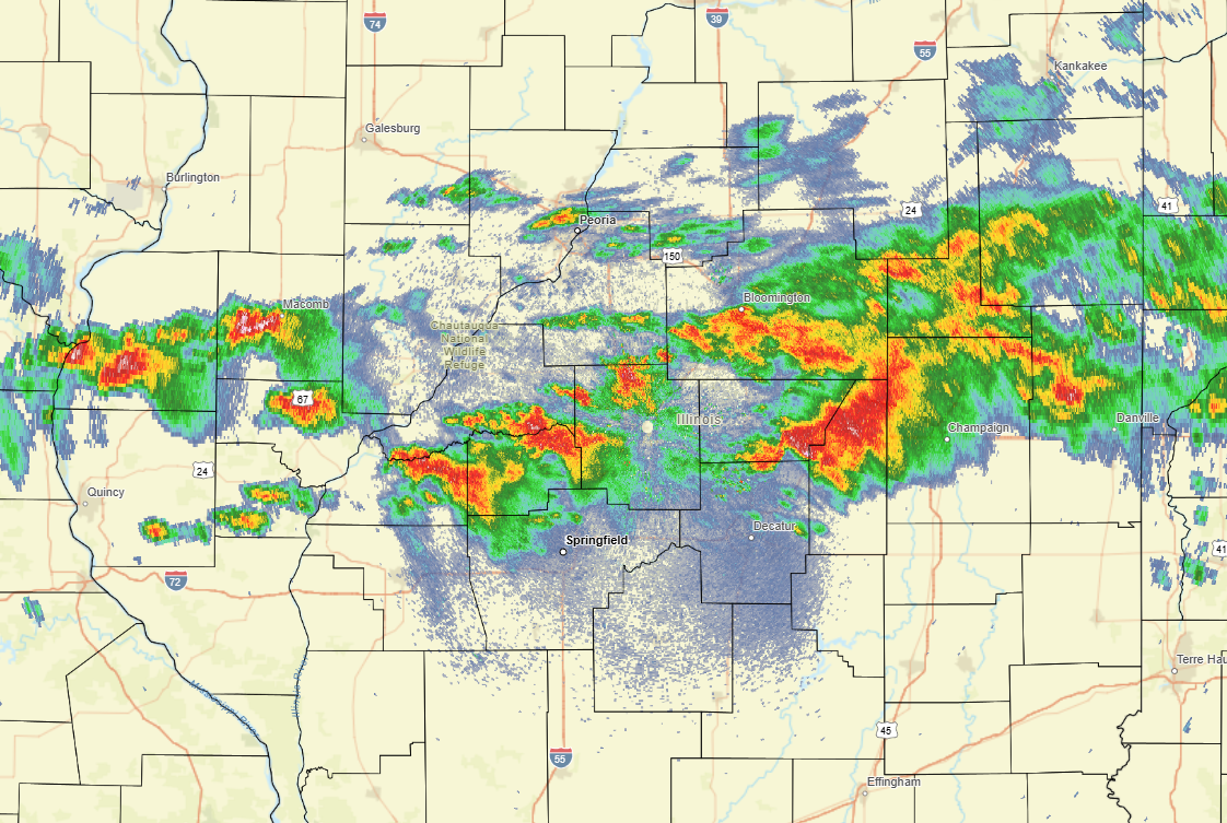
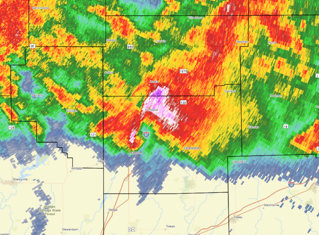
6:45pm CDT radar imagery showed an intense supercell interacting with the highly favorable environment across east-central Illinois. A well-defined hook echo was evident just north of Mattoon. This storm went on to produce damage on the north side of Mattoon into parts of Charleston. In addition, the high-reflectivity core of the storm had a history of dropping hailstones larger than baseballs (3" diameter) near Arthur and Humboldt. This particular cell was part of a family of supercells that had produced a swath of large hail and possible tornadoes from far eastern Sangamon County near Illiopolis southeastward through Decatur, Arthur, and Charleston before it eventually weakened. As the evening progressed, additional tornadic supercells impacted locations south of I-70...including Effingham where significant damage was reported. The storms gradually shifted south and east of the NWS Lincoln County Warning Area (CWA) after 10pm CDT.
RADAR IMAGERY 6:45PM CDT JUNE 17, 2026
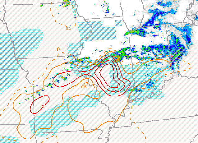
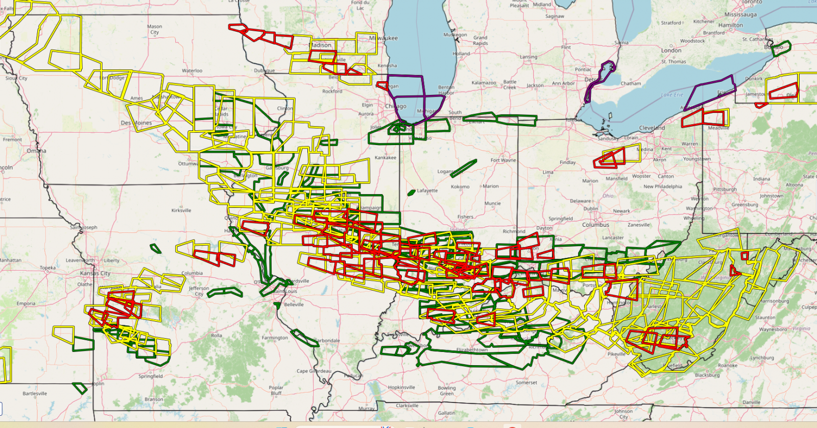
This was a significant weather event not only for central Illinois, but for surrounding areas as well. Here is a map highlighting all Severe Thunderstorm, Tornado, and Flash Flood Warnings issued by the National Weather Service on June 17th. A large swath of warnings stretched from Iowa southeastward into the Ohio River Valley. NWS Lincoln issued a total of 58 weather warnings.
JUNE 17, 2026 WARNINGS
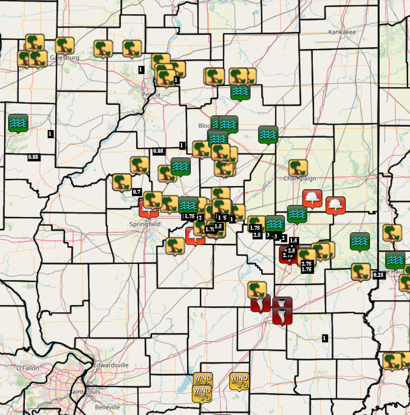
Here is a map of preliminary storm reports from across central Illinois. Storm damage surveys are currently underway, so additional details regarding specific tornado touchdowns and tracks will be made available over the next few days.
JUNE 17, 2026 REPORTS