July 13, 2016
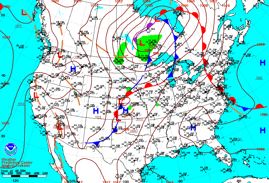
Several rounds of thunderstorms impacted central Illinois on July 13th, with a widespread damaging wind event taking place during the afternoon hours. Morning surface analysis (see map below) showed a 992mb low over northwestern Ontario, with a cold front extending southward through Michigan then southwestward into the Plains. The airmass ahead of the front was already quite warm and humid, with temperatures across central Illinois in the middle 70s and dewpoints around 70 degrees.
July 13, 2016 7am CDT Surface Weather Map
Scattered thunderstorms were ongoing in the morning as a result of a 30-35kt 850mb jet streak that had developed from Texas northeastward to Missouri during the previous night. This feature had sustained the storms with a constant supply of warm, moist air from the southwest through the overnight hours, with the convection then spreading into west-central Illinois during the morning. As the nocturnal jet weakened, the energy supply for the storms waned and thus this initial round of storms was not severe.
With the cold front expected to slowly approach from the northwest and a strong upper-level wave progged to track just north of the region, both NWS Lincoln and NWS Quad Cities performed special 18z/1pm upper air balloon launches to sample the pre-storm environment. These upper air soundings revealed Convective Available Potential Energy (CAPE) values of 1500-2500J/kg and 0-6km bulk shear of 20-25kt. With partial sunshine expected to further destabilize the atmosphere and shear set to increase as the upper wave got closer, the stage was set for potential severe weather later in the afternoon.
Meanwhile further west, a short-wave trough associated with a large cluster of thunderstorms that had developed across the western Plains the night before was tracking eastward and generating new convection across eastern Nebraska and western Missouri. As these storms organized and became more widespread, the Storm Prediction Center (SPC) began issuing Severe Thunderstorm Watches downstream from the developing storms. At 2:40 PM CDT, a Severe Thunderstorm Watch was issued for all of central and southeast Illinois valid through 9 PM CDT.
Severe Thunderstorm Watch #379
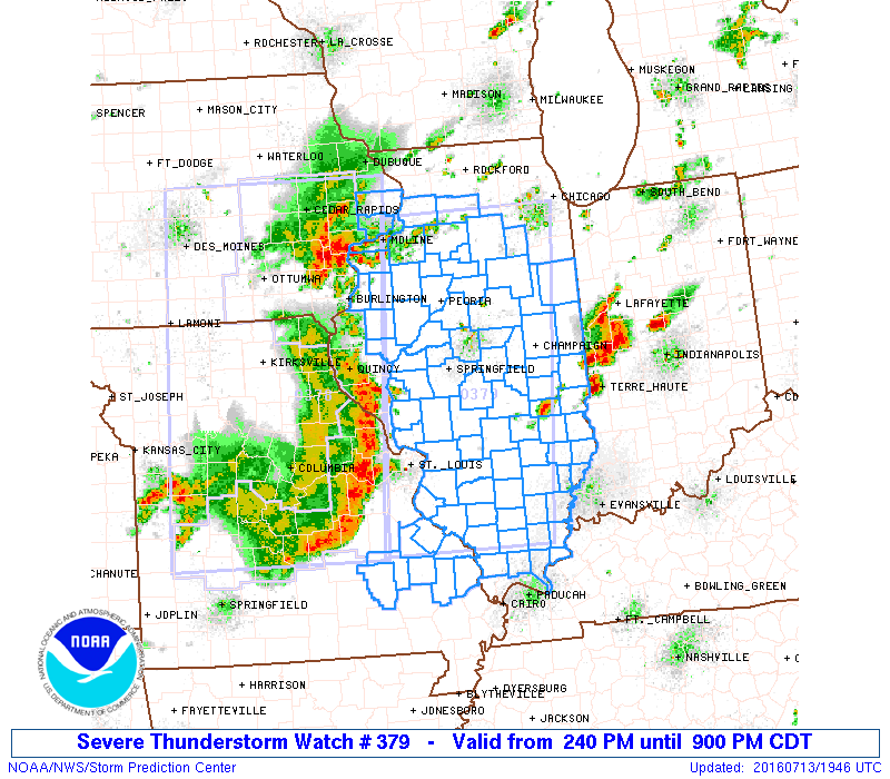
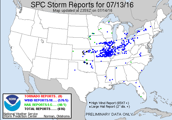
As the storms encountered the favorable environment across Missouri, they developed into an impressive line as they approached the Mississippi River. As you can see from the above radar image, a large bow echo structure had already developed...indicative of a damaging wind threat. Once the storms crossed the Mississippi River into west-central Illinois, wind damage reports began being received shortly after 3 PM CDT in Scott County, then further east to the I-55 corridor between 4 and 5 PM CDT...and finally to the Indiana border shortly after 6 PM CDT. The line of storms generally produced wind gusts of 40-50 mph as it passed through the region: however, there were embedded 60-70 mph gusts along the line that caused sporadic enhanced areas of wind damage. Particularly hard hit were the communities of Shelbyville, Mattoon, Louisville, Flora, and Olney...where numerous trees, large tree branches, and power lines were blown down. A mobile home was flipped over and destroyed, resulting in one injury just north of Sailor Springs in Clay County. In addition, the roof was blown off a building in downtown Shelbyville, the metal roof was peeled off the grandstand at the Richland County Fairgrounds in Olney, and several homes sustained roof and siding damage in Louisville in Clay County. Numerous trees toppled onto homes and vehicles, causing considerable property damage in those communities as well. Below is a map of all storm reports received across the U.S. on July 13th. Note the wide swath of blue dots representing wind damage reports from Missouri eastward across Illinois, Indiana, and Ohio.
July 13, 2016 Storm Reports