October 13, 2014
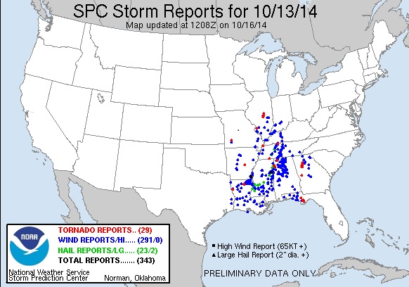
A slow-moving storm system spawned a severe weather outbreak across the middle and lower Mississippi River Valley on Monday, October 13th. Numerous reports of wind damage and tornadoes were received from the southern tip of Illinois southward to the Gulf Coast. While central Illinois was on the northern fringe of the storms, isolated severe weather occurred across the area, including 3 tornado touchdowns.
As a vigorous upper-level wave tracked southeastward across the Rockies, an area of surface low pressure developed over the Texas panhandle on Sunday, October 12th. The upper wave continued to amplify and eventually closed off from the prevailing jet stream winds to the north by Monday, October 13th. As a result, the forward speed of the system decreased markedly. The low pressure system gradually lifted northeastward, reaching northeast Missouri by Monday evening. Thanks to southerly flow through a deep layer of the atmosphere ahead of the slow-moving system, copious amounts of moisture were transported northward from the Gulf of America. Precipitable water values, which are a measure of the total amount of moisture contained within the entire depth of the atmosphere, climbed into the 99th percentile for this time of year by Monday afternoon and evening. With so much moisture available, locally heavy rainfall amounts of 1 to 1.50 inches occurred across much of the area. Widespread clouds and showers north of an advancing warm front kept the atmosphere rather stable across central Illinois for much of the day, with Convective Available Potential Energy (CAPE) values remaining less than 1000J/kg. Despite the lack of instability, the amplifying upper wave to the west created strong low-level wind shear. The increasing shear was enough to help a few of the thunderstorm cells become organized and begin rotating by mid to late afternoon. One of the strongest thunderstorm cells produced an EF2 tornado 3 miles E/NE of Moweaqua in far northern Shelby County. This tornado caused significant damage to a well-built home on the Shelby-Macon County line before crossing into southern Macon County and eventually dissipating. The parent thunderstorm that created the tornado went on to produce two more brief tornado touchdowns in eastern Macon County, including one near the IL-121/US-36 intersection just southeast of Decatur and another 3 miles northeast of Argenta. No significant damage was reported. Other thunderstorm cells produced damaging wind gusts that downed a few trees and tree branches in Dieterich in Effingham County and in the Charleston-Mattoon area.
Here is a map of all severe weather reports across the country on Monday, October 13th: