Severe thunderstorms capable of large hail and damaging wind gusts appear possible over the central and southern High Plains and eastern Kansas into Missouri Friday afternoon and evening. Rounds of storms Friday ahead of a slow moving frontal boundary will bring locally heavy rainfall and scattered flash flooding potential to the Mid-Mississippi, Ohio, and Tennessee Valleys, and the Appalachians. Read More >
November 5, 2017
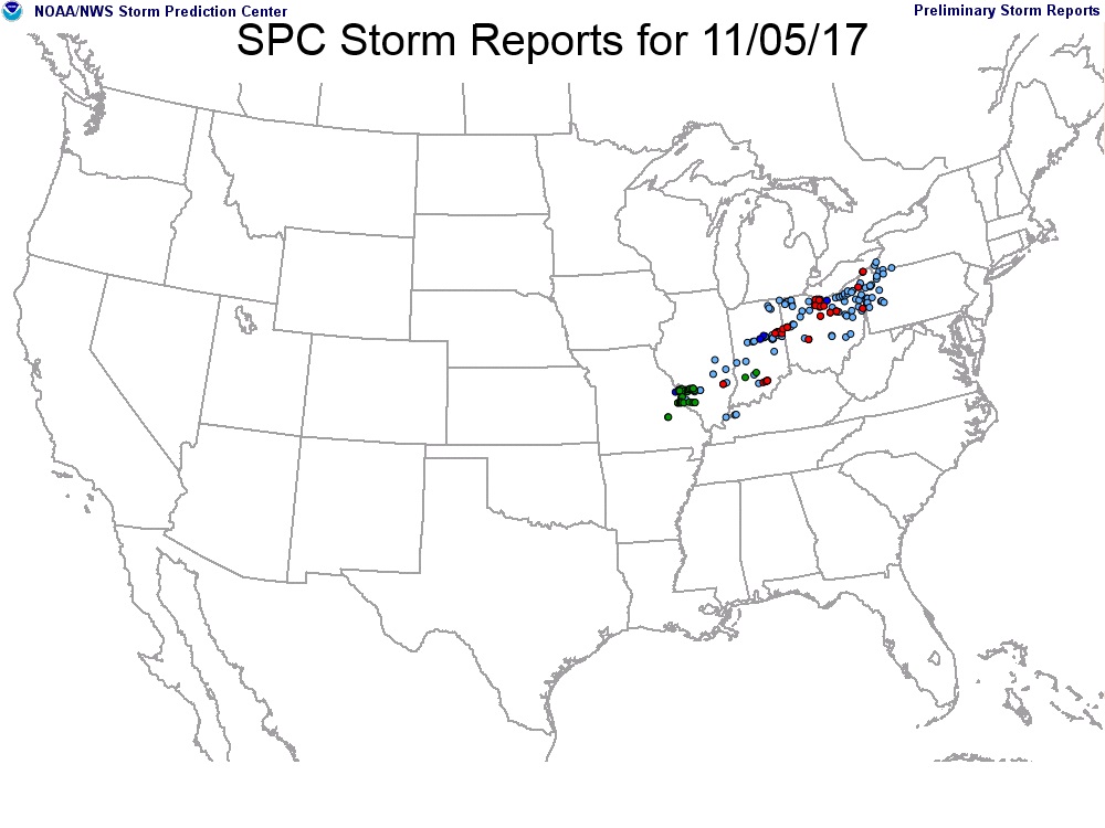
A slow-moving cold front triggered several clusters of strong to severe thunderstorms across east-central and southeast Illinois during the afternoon and early evening of Sunday, November 5th. Most of the activity developed along and southeast of a Champaign to Taylorville line...with the strongest storms producing wind gusts of around 60mph and hail up to the size of nickels. One cell spawned an EF-1 tornado in northern Richland County northwest of Olney...damaging a few structures and trees along its path. Storms further southwest along the front dropped very large hail up to the size of baseballs near Collinsville...while several tornadoes were reported to the northeast from eastern Indiana into northern Ohio.
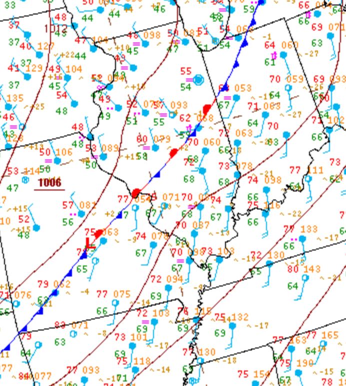
Surface analysis from 12pm November 5th showed a strong frontal boundary bisecting central Illinois...roughly along a line from near Champaign to just north of Saint Louis. Temperatures to the north of the front were only in the lower to middle 50s across north-central Illinois, while readings south of the boundary had climbed into the lower 70s. Thanks to the unseasonably warm and humid airmass in place, Convective Available Potential Energy (CAPE) values climbed into the 1500-2000J/kg across south-central Illinois during the afternoon...with even higher values of around 2500J/kg noted further southwest across southeast Missouri into southwest Illinois.
Surface Weather Map from 12pm November 5th
Due to the potential for volatile weather, several NWS offices were asked to perform a midday supplemental upper air sounding. NWS Lincoln was located in the cool sector of the system north of the front...so surface based instability was nearly non-existent. However, around 1000J/kg of elevated instability was noted. Further south, a balloon released by NWS Wilmington, Ohio showed much greater surface based instability, with CAPE values of nearly 1800J/kg. Both soundings measured very strong low-level wind shear of 50-65kt.
Upper Air Soundings from 12pm November 5th
Lincoln Wilmington, OH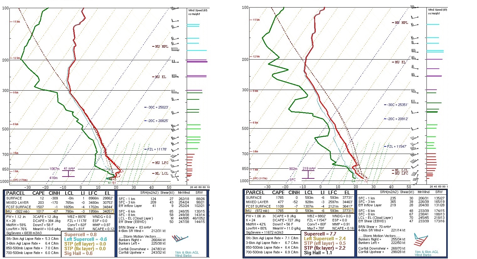
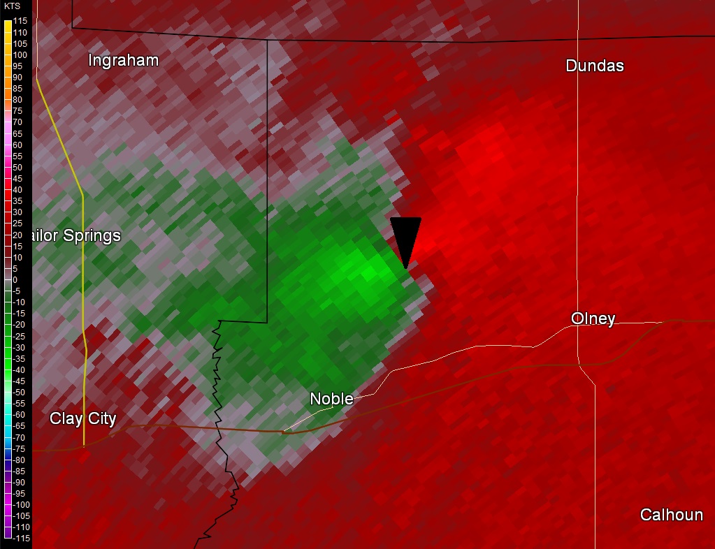
As the atmosphere continued to destabilize, thunderstorms began to develop near and just south of the frontal boundary by early afternoon. The cells tracked E/NE at 45-55mph, with some producing marginally severe hail and wind. Nickel-sized hail was reported at the Taylorville Airport, while penny-sized hail fell near Arthur in Douglas County. In addition, 50-60mph winds downed a power line in Arthur, as well as several large tree branches in Shumway in Effingham County and in Casey in Clark County. By late afternoon, a thunderstorm cell began to exhibit rotation over eastern Clay County. As the storm tracked into northern Richland County, the rotation couplet seen on Doppler radar tightened considerably and a tornado touched down about 3.4 miles north of the town of Noble. Based on an NWS Storm Survey conducted on Monday, November 6th...the EF-1 tornado remained on the ground for about 7 miles as it tracked E/NE, eventually lifting 3.2 miles northwest of Olney. The tornado damaged a barn, the roof of a house, a garage, and numerous trees along it's path. The image below is the Storm-Relative Motion (SRM) measured by NWS Doppler Radar located near Evansville, IN at 5:27pm. Note the close proximity of the green and red colors...indicating strong winds moving toward the radar (green) and away from the radar (red). The black triangle marks the approximate location of the tornado within the couplet.
Storm-Relative Motion (SRM) Imagery at 5:27PM CST November 5
Despite strong instability and impressive low-level wind shear across south-central Illinois, the NWS Lincoln County Warning Area (CWA) was largely spared from severe weather. Based on mesoanalysis and the corresponding regional reports, it appears severe weather favored areas of maximized instability and shear. During the afternoon of November 5th, the strongest instability developed across southeast Missouri into southwest Illinois, where CAPE values exceeded 2000J/kg. Meanwhile, the strongest wind shear remained across northern Indiana into northern Ohio. The map below shows all the severe weather reports received on November 5th. A cluster of very large hail reports was focused within the zone of greatest instability near the Saint Louis metro...while several tornadoes occurred further northeast within the area of strongest low-level wind shear from eastern Indiana into northern Ohio. In between, central Illinois enjoyed a relative minimum of severe weather.
Storm Reports from November 5, 2017