National Weather Service United States Department of Commerce


Top 10 Weather Events of 2017


1) February "Heatwave"

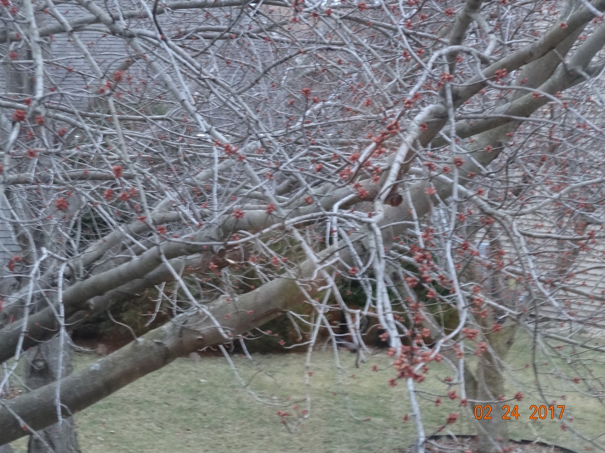
A persistent and unseasonably strong upper-level ridge of high pressure dominated the weather across the Midwest in mid and late February, resulting in record late winter warmth.  Average temperatures for the month ranged from 10 to 12 degrees above normal...including +9.6 degrees at Lincoln, +11.0 at Peoria, and +11.8 at Springfield.  The warmest weather occurred from February 16th through the 24th when high temperatures routinely climbed above 60 degrees.  A few days even saw readings rise into the 70s...peaking on February 20th when Lincoln and Peoria reached 74 degrees and Springfield topped out at 76.  While Lincoln and Springfield were just shy of all-time record highs for the month of February, Peoria tied their monthly record of 74 previously set on February 10, 1932.  Thanks to the incredibly warm conditions, many plants and trees began to break dormancy well before they typically do.  Here is a picture of a maple tree budding out on February 24th sent to us by one of our Peoria SWOP members.


========================================================================================================================

2) February 28th Tornadoes

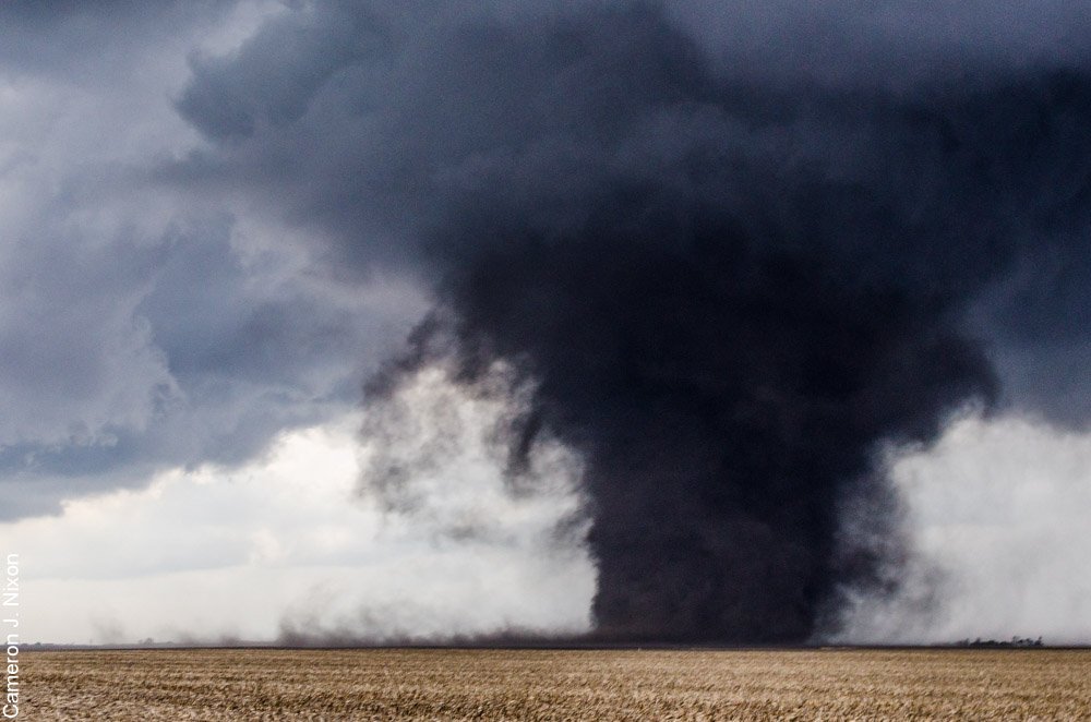
An unseasonably warm and humid airmass was in place across central Illinois on February 28th...with afternoon high temperatures soaring to record levels in the upper 60s and lower 70s. Thanks to these extremely warm temperatures and dewpoints surging into the upper 50s and lower 60s, Convective Available Potential Energy (CAPE) values exceeded 1500J/kg across Missouri and the western half of Illinois by late afternoon. In addition, a strong mid-level jet streak enhanced 0-6km wind shear to an impressive 60-70kt. While the airmass within the warm sector was initially capped, an approaching upper wave helped weaken the cap and set the stage for strong to severe thunderstorms into the evening. As a cold front pushed across the Mississippi River, supercell thunderstorms initiated across west-central Illinois during the late afternoon and lingered into the evening. These storms produced a total of 4 tornadoes in the National Weather Service Lincoln County Warning Area (CWA), including an EF-3 tornado that touched down west of Washburn in Woodford County.  The tornado broke windows and did roof damage to a house and destroyed several outbuildings about a mile from its origin. The tornado rapidly widened to more than 1/4 mile across and increased in intensity to EF-3 as it destroyed a house about 2.5 miles west of Washburn. One mile to the east, the tornado tore the roof off a house before moving into Washburn. The tornado damaged 8 houses in town...doing significant damage to roofs, garages, automobiles, and trees before crossing into extreme southern Marshall County and dissipating.  Cameron Nixon took this picture of the tornado near Washburn.


========================================================================================================================

3) Spring Lightning Storms

Our SWOP observer from Neoga in Cumberland County shared her top weather event of 2017.  A series of powerful thunderstorms during the spring created significant lightning activity in her area.  A nearby lightning strike created an electrical surge that destroyed her computer during one storm, then another storm just a short time later produced a close strike that took out her home phone.  Talk about lightning striking twice!


========================================================================================================================

 4) April 29th Damaging Wind Event

Low pressure tracking along a stationary frontal boundary near the I-70 corridor brought widespread strong to severe thunderstorms to much of central and southeast Illinois during the late afternoon and evening of April 29th.  A tornado briefly touched down in an open field northeast of Alexander in Morgan County. Elsewhere, thunderstorms packed winds of 60-70mph and caused significant wind damage.  A downburst with estimated winds of 80mph caused property damage of around $2 million in Middletown in Logan County.  Further south, powerful thunderstorm winds derailed 6 empty train coal cars near Chatham in Sangamon County.  In addition to the strong winds, many of the storms dropped copious amounts of rain, causing widespread flash flooding.  Numerous roads were closed due to high
water, including Highway 29 north of the McClugage Bridge in Peoria where a mudslide occurred.  Paul Hadfield, our long-time SWOP member from Decatur submitted this impressive shelf cloud picture taken near Morrisonville during the peak of the storms.


======================================================================================================================

5) May 10th Damaging Winds

A cluster of strong to severe thunderstorms developed in advance of an area of low pressure across southeast
Iowa during the afternoon of May 10th. The storms then developed into a squall line and raced east-southeast
along a warm front draped across central Illinois during the late afternoon and early evening. One tornado
touched down along the line just south of Argenta in Macon County, while widespread wind damage was
reported primarily along and south of I-72.  One of our SWOP members in Springfield experienced damage
at his location, likely due to a downburst. 


====================================================================================================================

6) May 17th Dust Storm

Strong southerly winds gusting to between 35 and 45mph lifted dust from recently dried fields to create
significant reductions in visibility across central Illinois during the afternoon and evening of May 17th.  Blowing
dust cut the visibility to near zero in some locations, prompting closures of several major roadways.  Portions
of I-72 on the south side of Springfield, as well as near New Berlin were closed for a time.  I-55 near McLean
and IL-104 between I-55 and Auburn were temporarily closed as well. Numerous traffic accidents occurred
due to the blowing dust, including two that resulted in fatalities.  One person died in an accident on I-72 near
New Berlin, and another person was killed in a 6-car accident on Route 36 near Tuscola.  Our Decatur SWOP
snapped the following picture of the blowing dust near Warrensburg.


====================================================================================================
7) May 26th Tornado and Wind Damage in Northern Vermilion County
 
Supercell thunderstorms developed in the vicinity of a warm front draped along the I-74 corridor during the
afternoon and early evening of May 26th.  The hardest hit area was northern Vermilion County...where
powerful cells produced a tornado, damaging winds, and extremely large hail.  An EF-1 tornado touched
down northwest of Alvin, damaging trees, the roof and siding of a house, and a garage.  Meanwhile,
80-90mph winds produced nearly $3 million worth of tree and property damage in Rossville.  Very large
hail up to the size of tennis balls were reported in Rankin.  In addition, extreme rainfall rates caused flash
flooding in Hoopeston.


===================================================================================================
8) July 10th-11th Wind Damage
 
My personal pick for biggest weather event of 2017 would be the damaging thunderstorm winds of July 10th
and 11th.  Lincoln was impacted by 60-65mph winds at around 8:30PM CDT on July 10th, then again just 12
hours later at 9:00AM CDT July 11th.  Numerous trees and tree branches were blown down around town. 
I remember driving around and seeing piles of downed branches at nearly every property I passed.  I'd
never seen such widespread tree damage.  The storms were triggered by a nearly stationary frontal
boundary extending from southern Lake Michigan southwestward to the Iowa/Missouri border.  The first
round of convection was primarily confined to locations along and west of I-55 during the evening of the
10th, while the second round focused in a swath from Logan County eastward to Champaign and Vermilion
counties during the morning of the 11th. Braden Connor took this picture of damaged power poles on the
west side of Lincoln as a result of the July 10th storms.


===================================================================================================================
9) Very Large Hail
 
Another thing that sticks out in my mind is the unusual number of very large hail reports across central
Illinois this year.  Thunderstorms typically produce hail ranging from pea to quarter-sized around here,
occasionally up to the size of golfballs.  This year however, we saw 3 separate days where hail greater
than 2" in diameter occurred!  The largest observed hailstones measuring a whopping 2.75" in
diameter (or the size of baseballs) fell in Hoopeston in Vermilion County on March 20th.  2.5" hail
(the size of tennis balls) was observed in Rankin in Vermilion County on May 26th and in Fairview in 
Fulton County on July 10th.  For more information on the historical occurrence of very large hail across
central Illinois, please see: http://www.weather.gov/ilx/largehailcentralil


==================================================================================================
10) Late Summer Drought


After a wet spring, conditions began to dry during the summer...as upper ridging became more prominent
across the region.  August and September were particularly dry months, with monthly rainfall deficits of 2
to 3 inches.  In fact, September turned out to be Springfield's second driest month ever recorded after only
0.01 rainfall was measured!  Due to the very warm and dry weather, Moderate Drought conditions developed
from near Jacksonville eastward to Paris by the middle of September.  Our SWOP observer in Lawrenceville
recalls the developing drought as his farm pond dropped more than 3 feet.  For reference, here is the Illinois
Drought Monitor issued on September 19th.


==================================================================================================