Top 10 Weather Events of 2021
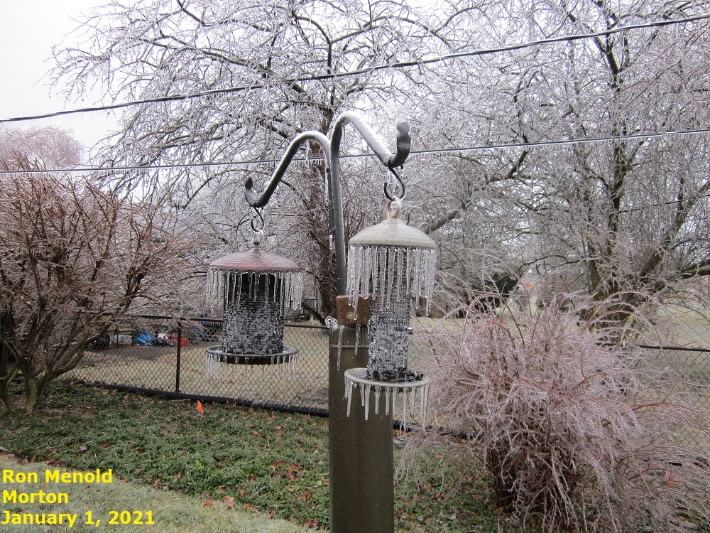
1) January 1: Ice Storm
Low pressure tracking from eastern Oklahoma during the early morning of January 1st to northern Indiana by the evening of the 1st brought a prolonged period of freezing rain to much of north-central Illinois. Storm total ice accumulations in excess of one quarter of an inch were common along and north of a Rushville...to Lincoln...to Saybrook line, with some locations across portions of Woodford and Fulton counties measuring up to one half of an inch. Due to heavy ice accumulations and northeasterly winds gusting over 20mph, numerous tree branches were snapped...resulting in scattered power outages across the area.
=====================================================================================================
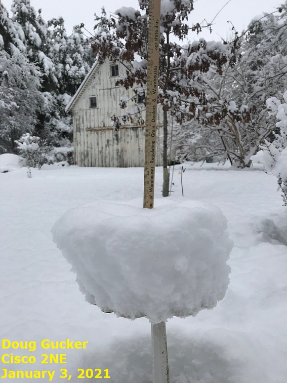
2) January 2-3: Heavy Snowfall Along I-72
An upper-level wave and its associated weak surface low tracked slowly northward from the Ozarks around midday January 2nd into northern Indiana by the early morning of January 3rd. The system brought widespread light snow to central Illinois, with amounts of 2 to 5 inches common east of the Illinois River and north of I-70. As the wave slowed and pivoted out of the region, a mesoscale snow band persisted across a small portion of central Illinois until the pre-dawn hours of January 3rd. As a result, much heavier snowfall totals of 5 to 10 inches were focused across Macon, DeWitt, and Piatt counties.
=====================================================================================================
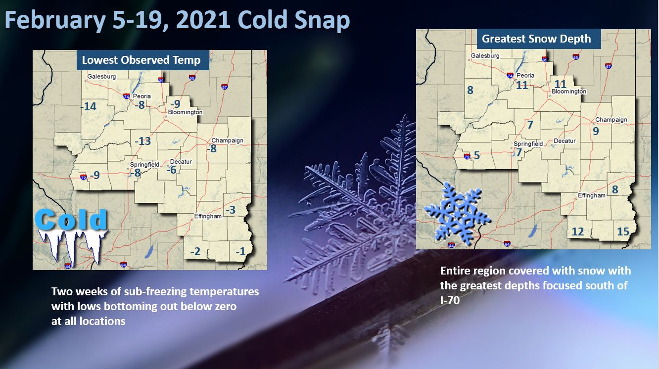
3) February 5-19: Prolonged Cold Snap
A prolonged period of very cold conditions gripped central and southeast Illinois in mid-February. The first intrusion of Arctic air arrived on February 5th...followed by several additional shots that kept the region locked in a deep-freeze until February 19th. Most recording sites across central Illinois remained below freezing for 15 straight days before readings gradually returned to normal by the end of the month. While no daily low temperature records were established, the unusually long stretch of extreme cold helped drive average monthly temperatures to a staggering 10 degrees below normal. All sites across the NWS Lincoln County Warning Area(CWA) reported sub-zero temperatures at some point during this time period, with the coldest readings focused from February 13th through 15th when daytime highs remained in the single digits above zero.
======================================================================================================
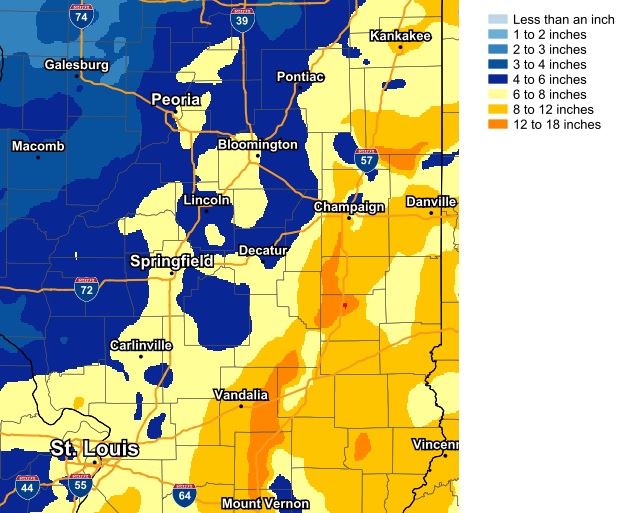
4) February 14-16: Heavy Snow
Canadian high pressure anchored over the Northern Plains allowed an extremely cold airmass to filter southward into central Illinois on February 14th, resulting in afternoon high temperatures only reaching the single digits above zero everywhere north of the I-70 corridor. While the Arctic cold front responsible for the cold snap was stalled well to the south over the northern Gulf of America, an upper-level disturbance interacted with a weak surface trough to produce a prolonged period of snow from the evening of February 14th through the morning of February 16th. Storm total snowfall was greatest east of the Illinois River, where amounts in excess of 5 inches were common. The highest snow totals of 8 to 12 inches were focused across east-central Illinois along and east of the I-57 corridor. Here are some of the greatest measured snow amounts:
| CITY | COUNTY | SNOWFALL |
| Urbana 2SSE | Champaign | 11.9 |
| Olney 2NE | Richland | 11.8 |
| Mattoon | Coles | 11.5 |
| Bismarck 1W | Vermilion | 11.5 |
| Effingham | Effingham | 11.3 |
| Lawrenceville 2W | Lawrence | 11.2 |
| Robinson 3W | Crawford | 11.0 |
=====================================================================================================
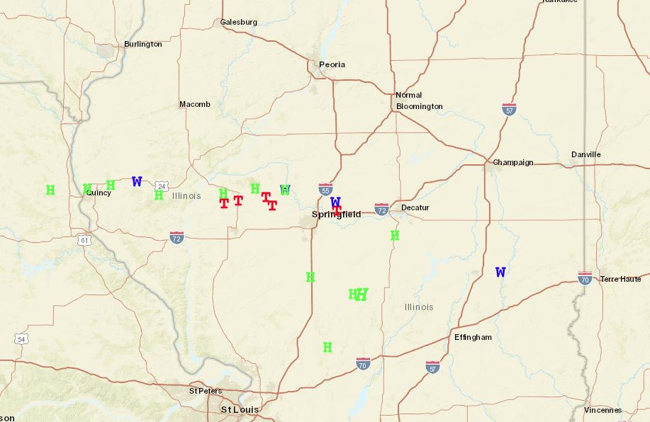
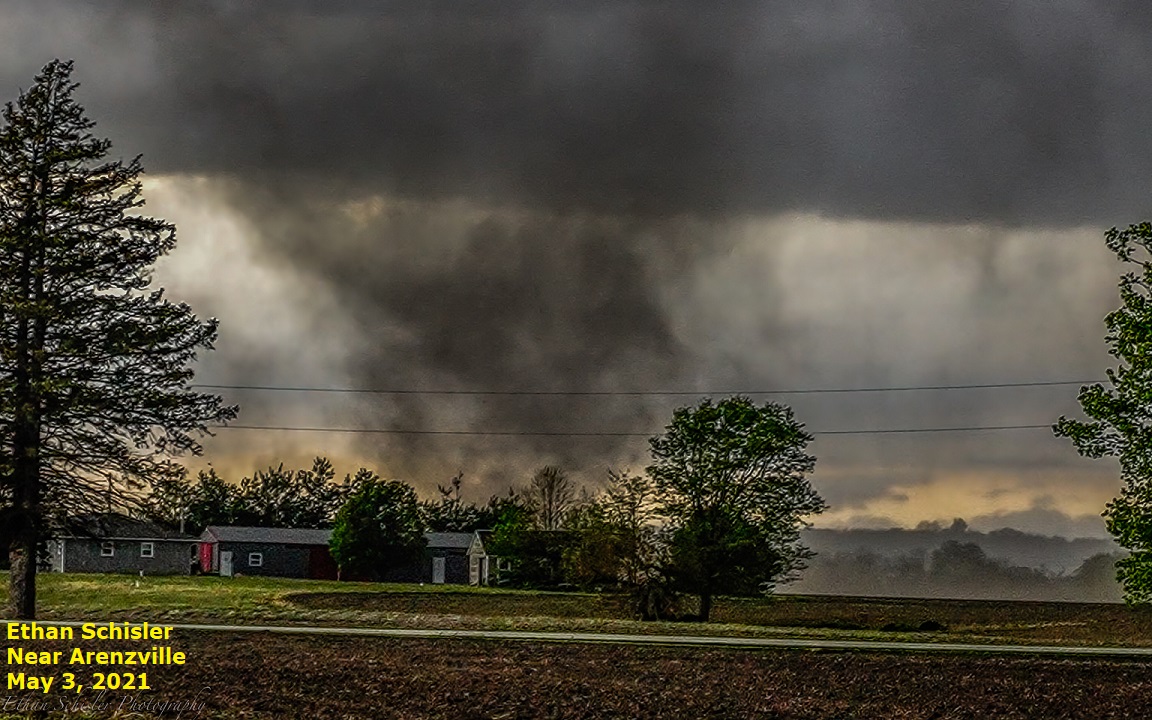
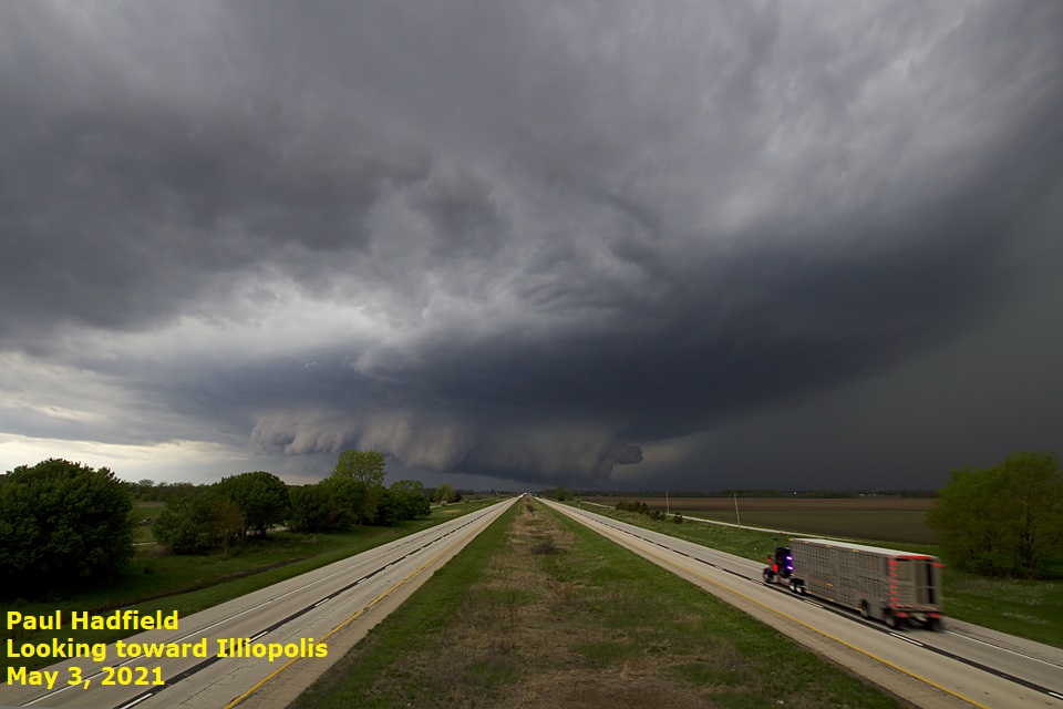
5) May 3: Five Tornadoes and Very Large Hail
A Mesoscale Convective Vortex (MCV) generated by a large cluster of convection across Kansas during the pre-dawn hours tracked eastward into central Illinois by the late afternoon and evening of May 3rd. Despite weak instability and deep-layer synoptic shear, the MCV was able to enhance the low-level shear and trigger a broken line of convection. One of the cells on the east-southeast flank of the MCV became a supercell and tracked across central Illinois from Cass County southeastward to Coles County before dissipating after dark. That particular storm produced five brief tornado touchdowns and hail as large as half dollars along its path. Another thunderstorm cell further south dropped 2-inch diameter hail in southern Christian County. This was the largest hailstone observed within the National Weather Service Lincoln County Warning Area (CWA) for all of 2021.
 |
 |
=====================================================================================================
6) June 18-19: Wind Damage
Waves of low pressure tracking along a nearly stationary frontal boundary draped across central Illinois triggered strong to severe thunderstorms from the evening of June 18th through the early morning of June 19th. One of the storms produced an EF-1 tornado east of Abingdon in Knox County. The tornado flattened crops and caused significant damage to a few outbuildings. South of the tornado track, estimated 70 to 90 mph straight line winds caused damage in London Mills, Fairview, and Canton in northern Fulton County. As the storms continued eastward, numerous reports of wind damage were received across southern Peoria County into portions of Tazewell and McLean counties.
=====================================================================================================
7) June 25-26: Historic Flash Flooding Across Southern McLean County
A series of disturbances tracking along a nearly stationary frontal boundary resulted in two periods of heavy rainfall across parts of central Illinois on June 25th and June 26th. The hardest hit areas were across southern McLean County into far northern Logan County, as well as across southern portions of Scott and Morgan counties. The first wave of heavy rain began around 7pm CDT June 25th and persisted until around 11pm that evening before tapering off. Rainfall amounts across southern McLean County ranged from 4 to 7 inches in 4 hours, with the heaviest rain extending from near the town of McLean through Bloomington-Normal southeastward toward LeRoy. The second wave of heavy rain occurred during the afternoon of June 26th when additional amounts of 2 to 4 inches fell across the same areas of southern McLean County that had been impacted the previous evening. Storm total rainfall between 6pm CDT June 25th and 6pm CDT June 26th ranged from 6 to 11 inches across southern McLean County, with a maximum amount of 10.71 inches measured 1.5 miles east-southeast of Bloomington...which represented a 1,000-year rainfall (0.1 percent chance of occurring in any given year). Locations from Funks Grove through Shirley to southern and eastern parts of Bloomington experienced a 500-year rainfall (0.2 percent chance of occurring in any given year). Due to the tremendous amount of rainfall, significant flash flooding occurred across central and southern McLean County into far northern Logan County, including the city of Bloomington. Numerous roads were closed due to high water, several water rescues needed to be performed due to stranded motorists, part of the I-55 shoulder collapsed near Kickapoo Creek, and Kickapoo Creek reached record levels and flooded several homes in Lawndale in far northern Logan County.
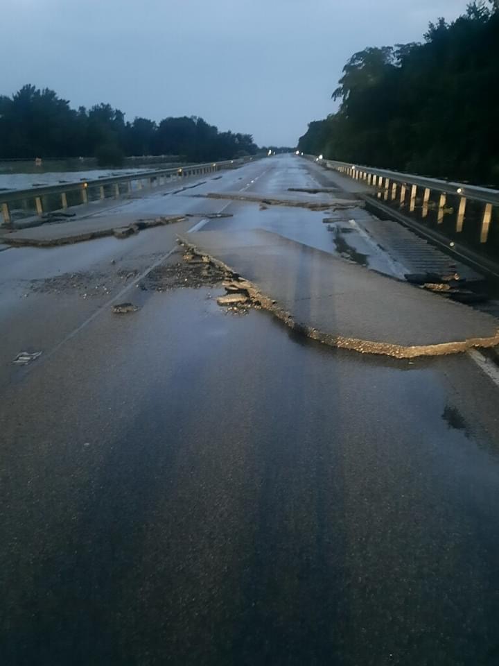
Photo courtesy of Mt. Hope and Funks Grove Fire Protection District
=====================================================================================================
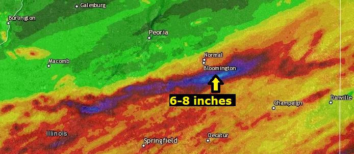
8) July 16-17: Flooding in Southern McLean County (Again)
A slow-moving cold front interacting with a moist environment triggered bands of showers with a few embedded thunderstorms across central Illinois during the morning of July 16th. One persistent band continued to back-build over portions of southern McLean County for several hours, dropping 6 to 8 inches of rain. Due to the excessive rainfall occurring on already saturated soils, flash flooding prompted the closure of numerous roads between Heyworth, Downs, and Leroy. Many roads remained flooded until midday on July 17th when the water finally began to recede.
July 16 Rainfall
=====================================================================================================
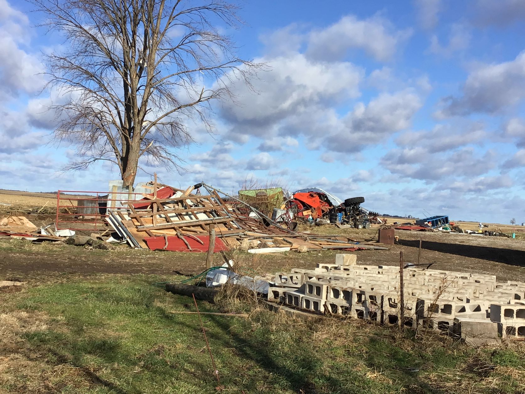
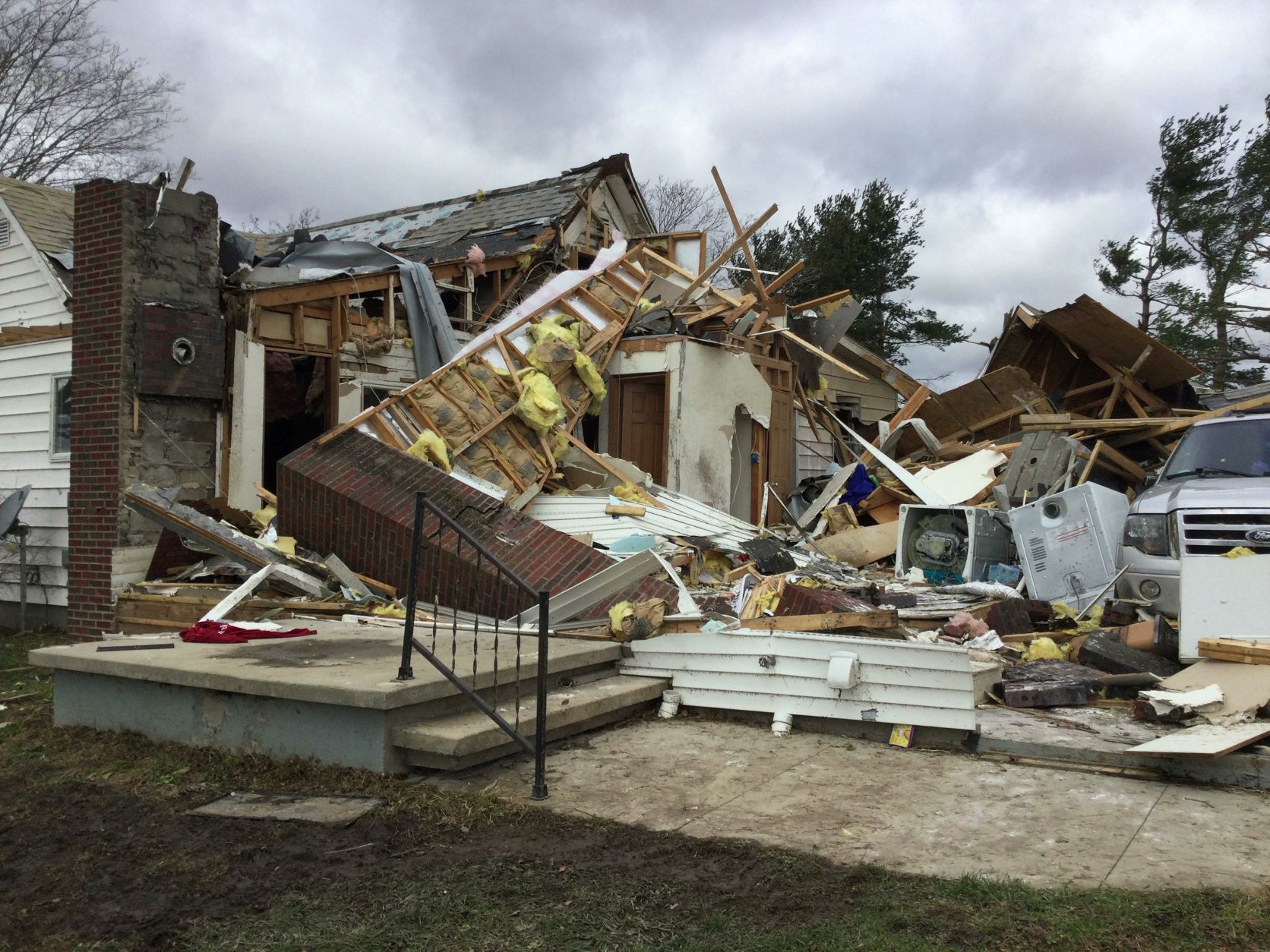
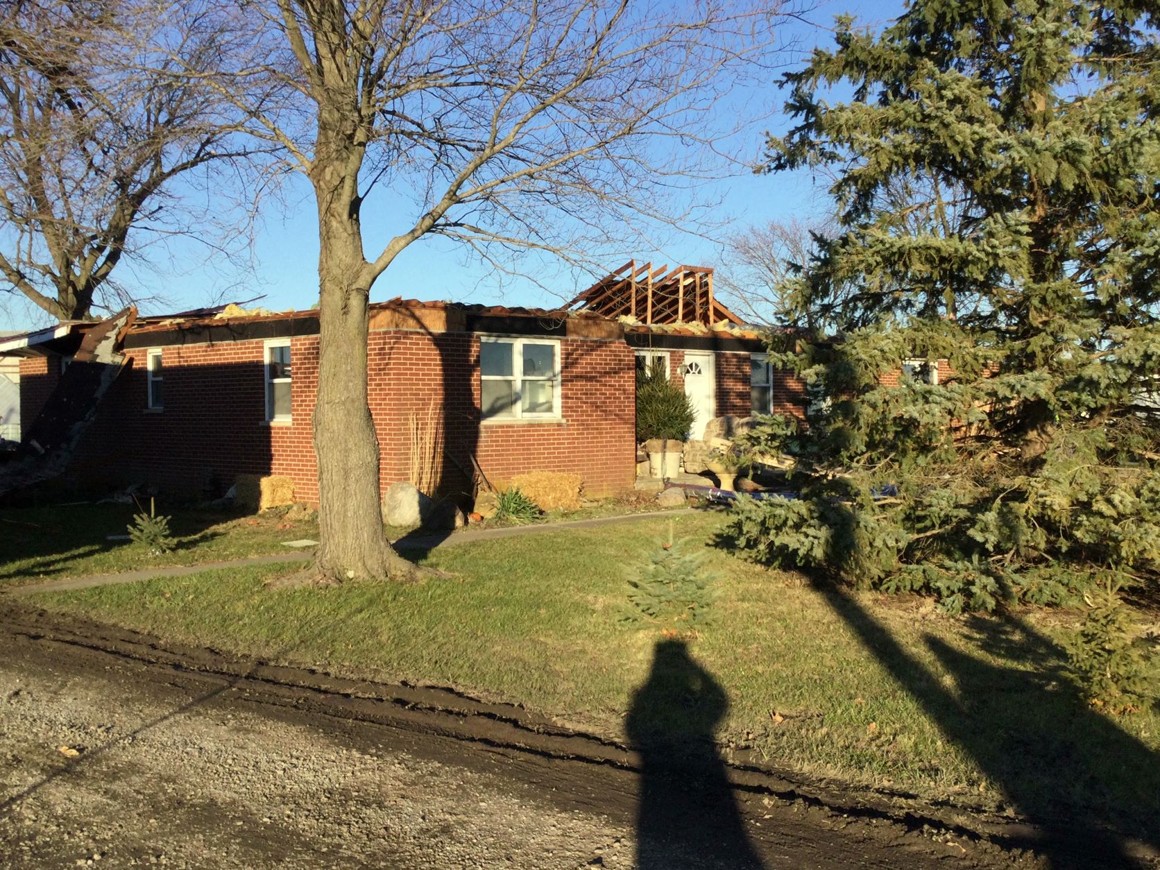
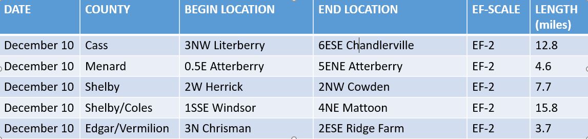
9) December 10: 5 EF-2 Tornadoes
Low pressure tracking from near Kansas City during the afternoon of December 10th to southern Lake Michigan by the pre-dawn hours of December 11th brought a significant severe weather event to central Illinois. Warm air surging northward ahead of the system pushed temperatures into the 60s during the evening hours...resulting in Convective Available Potential Energy (CAPE) values in excess of 1000J/kg. In addition, very strong low-level wind shear in close proximity to the low and its associated warm front arcing eastward into north-central Illinois led to the development of numerous rotating thunderstorm cells. A total of 5 tornadoes touched down across the NWS Lincoln County Warning Area (CWA), all of which were ranked EF-2 during subsequent storm surveys. The most significant damage occurred across portions of Shelby and Coles counties. One person was injured just north of Herrick in Shelby County when an addition to their home was severely damaged. Further northeast, an agriculture services plant was destroyed west of Gays in far southern Moultrie County...and numerous houses and outbuildings were damaged across western Coles County from just west of Mattoon to northeast of Mattoon.
South of Virginia (Cass County)
North of Herrick (Shelby County)
North of Mattoon (Coles County)
=====================================================================================================
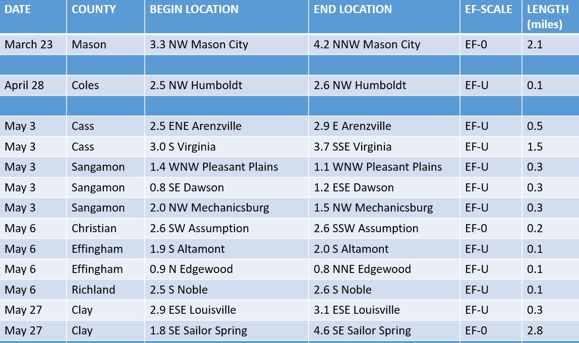
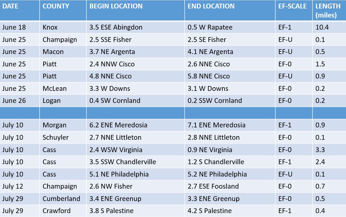
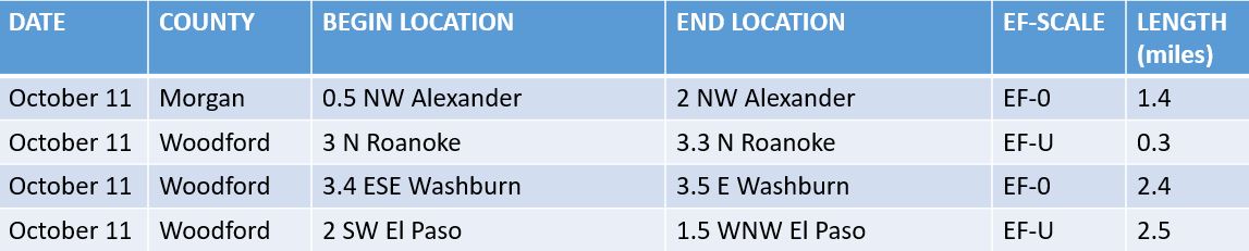
10) 37 Tornadoes Across Central Illinois in 2021
A typical year sees 20-25 tornado touchdowns within the NWS Lincoln County Warning Area (CWA). While we documented 37 tornadoes in 2021, it is interesting to note the majority of them were ranked either EF-U or EF-0 resulting in little to no damage. By far the most destructive day of the year was December 10th when we saw 5 EF-2 tornadoes across central Illinois. Below is a listing of all tornado touchdowns for 2021.
Spring
Summer
Fall
Winter
=====================================================================================================

