Central Illinois
Weather Forecast Office
October 13-15, 2026 Rainfall
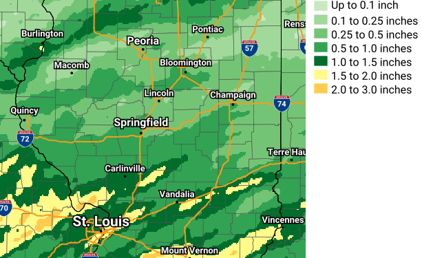
| CITY | COUNTY | RAINFALL |
| Watson | Effingham | 1.34 |
| Alma | Marion | 1.10 |
| Bunnyville | Clay | 0.80 |
| Urbana 2ENE | Champaign | 0.75 |
| Havana | Mason | 0.68 |
| Lovington | Moultrie | 0.66 |
| Bloomington 2E | McLean | 0.65 |
| Bridgeport 1SW | Lawrence | 0.59 |
| Towanda 2N | McLean | 0.57 |
| Chatham 1.4ESE | Sangamon | 0.57 |
| Ogden | Champaign | 0.56 |
| Mattoon | Coles | 0.53 |
| Lake Springfield | Sangamon | 0.53 |
| Morton | Tazewell | 0.48 |
| Cisco 2NE | Piatt | 0.47 |
| Bismarck 3W | Vermilion | 0.46 |
| Tuscola | Douglas | 0.40 |
| West Peoria | Peoria | 0.38 |
| Littleton 1NW | Schuyler | 0.37 |
| Danville | Vermilion | 0.36 |
| Astoria | Fulton | 0.35 |
| Peoria 2.4NW | Peoria | 0.33 |
| Washington | Tazewell | 0.27 |
| Lincoln NWS | Logan | 0.18 |
| Carlock 2NE | McLean | 0.15 |

US Dept of Commerce
National Oceanic and Atmospheric Administration
National Weather Service
Central Illinois
1362 State Route 10
Lincoln, IL 62656
217-732-7321 (forecast recording) or 217-732-3089
Comments? Questions? Please Contact Us.


 Follow us on X
 Follow us on Facebook
 Follow us on YouTube
 ILX RSS Feed