Week 4: How are Severe Thunderstorm and Tornado Watches Issued?
The Storm Prediction Center (SPC) works in conjunction with local National Weather Service offices to coordinate the issuance of convective weather watches. Predicting severe weather is a complex and challenging process and thus requires a multi-step collaborative effort in order to produce the most accurate and efficient results. Various computer models such as the Global Forecast System (GFS) are monitored days in advance in order to project general areas where potentially severe convection is expected to develop. As the event nears, higher resolution short-term models like the North American Mesoscale (NAM) and High Resolution Rapid Refresh (HRRR) help better define the threat. Finally, real-time satellite, radar, and observational data are utilized in order to hone in on specific location and timing details leading to a possible convective weather watch.
STEP 1: Convective Outlook
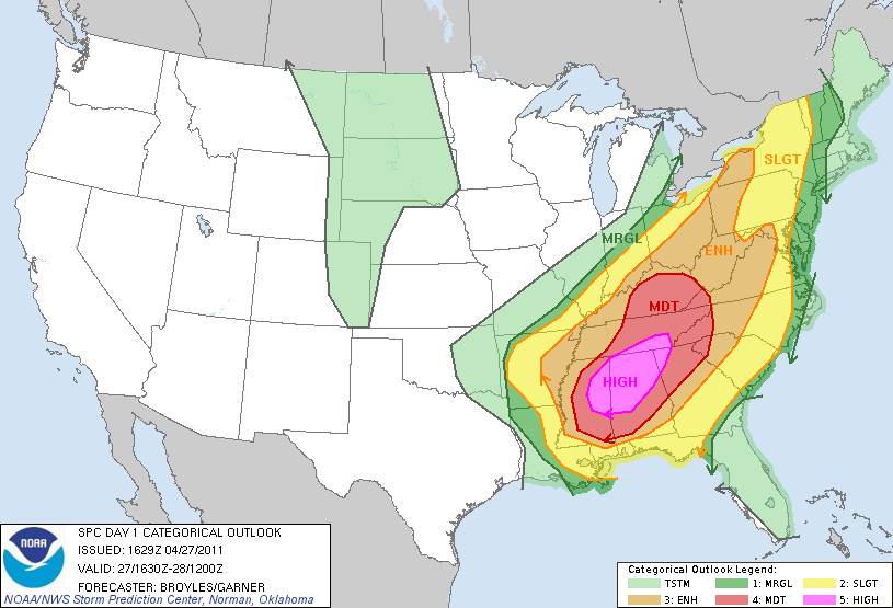
After a thorough model analysis is performed, forecasters at the SPC create outlooks for the entire country outlining the chances for severe thunderstorms over the next 1 to 8 days. These outlooks are produced daily and are used as preliminary guidance for local NWS forecasts and products such as the Hazardous Weather Outlook (HWO). The Day 1 and Day 2 convective outlooks are broken down into 6 categories based on the probabilities of severe weather occurring within 25 miles of a point. Here is a description of each of the categories depicted on the Day 1 Convective Outlook map below:
| COLOR | CATEGORY | DESCRIPTION |
| Light Green | General Thunder | non-severe thunderstorms possible |
| Dark Green | Marginal Risk | isolated severe thunderstorms |
| Yellow | Slight Risk | scattered severe thunderstorms |
| Orange | Enhanced Slight Risk | increasing coverage of severe thunderstorms |
| Red | Moderate Risk | widespread severe thunderstorms, some long-lived and intense |
| Magenta | High Risk | major severe weather outbreak, long-lived intense storms |
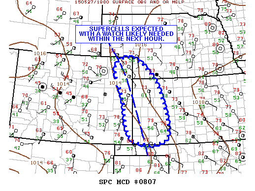
STEP 2: Mesoscale Convective Discussion
Once areas of potential severe thunderstorm development have been identified by the Convective Outlooks, the next step is to closely monitor real-time satellite and radar data. SPC forecasters will look for rapidly forming cumulus fields, outflow boundaries from previous convection, wind shift lines, and other mesoscale features for signs of imminent convective development within the next 6 hours. If an area of concern arises, they will issue a Mesoscale Convective Discussion (MCD) highlighting the geographical location and the specific threat. Included within the text of the product will be a probability of watch issuance statement, which helps NWS field offices better gauge the potential for severe weather within their local area. Below is an example of an MCD issued at 1 PM CDT on May 27, 2015 for eastern Colorado and western Kansas. The graphic includes the specific hatched area where severe weather is possible, as well as a statement about potential watch issuance.
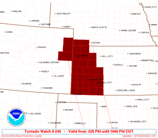
STEP 3: Watch Issuance
After an MCD has been issued, the area in question continues to be carefully scrutinized until the decision is reached to issue a watch. At this point, the SPC will send a proposed watch to all potentially impacted NWS field offices and alert them to a live conference call to discuss the impending event. During the call, the SPC forecaster will thoroughly explain his or her reasoning for the watch and ask for input from each field office. Some of the items that may be discussed include the type of watch to be issued, the timing of the watch, and the specific counties to be included. Once a consensus is reached, the watch is disseminated to our media and public partners as quickly as possible. The image below shows a Tornado Watch issued at 2:25 PM CDT for the same location across eastern Colorado and western Kansas that had been highlighted by an MCD nearly an hour and a half prior.
Once the watch is active, local NWS offices monitor the thunderstorms on Doppler radar and issue any pertinent warnings or statements for their local areas. Meanwhile, the SPC continues to monitor the severe weather potential across the entire country, providing periodic updates on existing convective watches and future areas of concern. As the threat for severe weather ends, NWS forecasters will coordinate with neighboring offices and the SPC in order to remove counties from the watch as needed.

