Week 3: El Nino
El Nino refers to a periodic warming of the central and eastern equatorial Pacific Ocean offshore from Ecuador and northern Peru, typically between 5N and 5S latitude and between 170W and 120W longitude. Once an El Nino event commences, a number of atmospheric changes occur worldwide as a result of a disruption of the normal pressure pattern over the Pacific Ocean. In order to better understand these changes and the potential impact on winter weather across central Illinois, we must first examine the normal ocean-atmosphere interaction across this area.
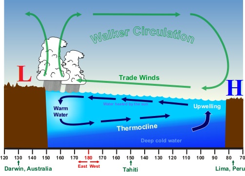
Under typical conditions, high pressure resides over the coast of South America while low pressure is in place over Indonesia. Since air flows from high pressure toward low pressure, this creates prevailing trade winds that blow from east to west near the Equator. Over time, these steady winds tend to push the ocean waters westward, resulting in average sea-level heights of approximately 1 1/2 feet higher off the coast of Indonesia than offshore of Peru. As the surface water sloshes westward away from South America...cold, nutrient-rich water from deep below upwells toward the surface. This creates relatively cool water temperatures and therefore prime fishing conditions off the coast of Ecuador and Peru. The diagram below depicts the typical trade wind pattern over the equatorial Pacific Ocean. The green arrows show the prevailing airflow from high pressure (east) to low pressure (west), while the blue arrows demonstrate how the trade winds impact the ocean currents. Note the typical upwelling conditions off the South American coast.
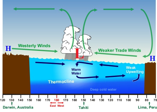
El Nino conditions develop when high pressure over coastal South America weakens, causing the corresponding east to west trade winds to also weaken or even reverese. With lighter easterly winds in place, less surface water is sloshed westward and upwelling decreases or ceases. With time and continued solar insolation, water temperatures offshore from Ecuador and Peru rise. The Climate Prediction Center(CPC) declares an El Nino event when the 3-month average sea-surface temperature departure exceeds 0.5C. In other words, when the average water temperature rises at least 0.5C above normal in that area over a 3-month period, it is officially classified as an El Nino. El Nino represents the warm phase of the El Nino Southern Oscillation (ENSO) cycle. The cold phase is often referred to as La Nina.
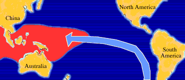
The image below shows sea-surface temperatures during an El Nino event. The red color represents the warmer water that is usually confined to the western Pacific Ocean pushing back eastward due to weakening trade winds.
Developing El Nino
Warmer than normal water piling up off the coast of Central and South America creates a strong sea-surface temperature diferernce between the Equatorial waters and the prevailing cold current of water further north off the coast of California associated with the North Pacifc Gyre. Below is a graphic depicting the mean circulation in the North Pacific Ocean. Note the cold north-to-south flowing current off the coast of California (blue arrow).
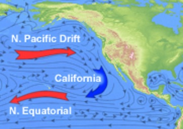
North Pacific Gyre
When the cold surface water from the North Pacific Gyre approaches the warm El Nino waters further south, the temperature difference (or gradient) between the two masses of water tends to strengthen the subtropical jet stream. In turn, the stronger southern jet stream creates a more active southern storm track and typically leads to above average rainfall across the Southern United States. Meanwhile, the polar jet stream usually remains much further north across Canada, keeping the coldest airmass locked up well to the north and creating above average temperatures from southern Alaska into the Pacific Northwest and the Northern Plains. The implications across central Illinois are a bit less certain, but typically trend toward above normal temperatures and below normal precipitation as the two prevailing jet streams remain separate.
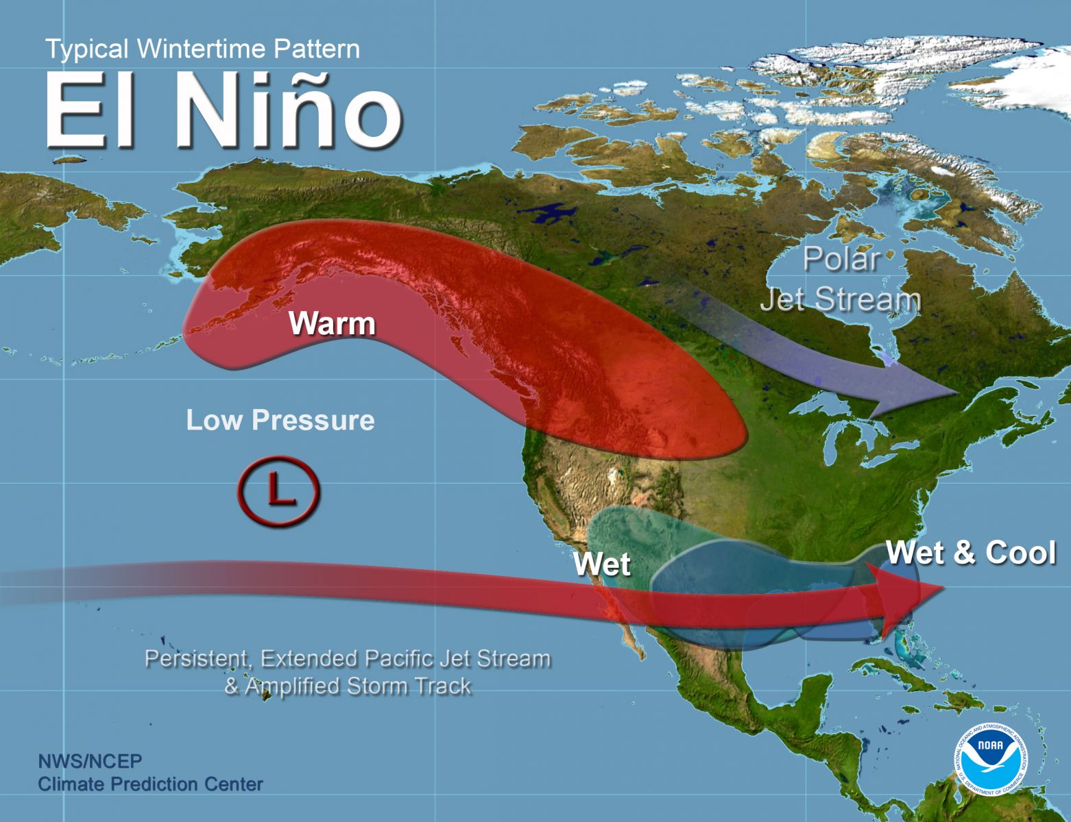
El Nino Winter Weather Pattern Across North America
While the map above shows typical wintertime weather conditions associated with El Nino, it should be noted that no two events are alike and therefore conditions will vary from event to event. For example, the exact location, strength, and timing of an El Nino episode may play a role in the eventual global weather impacts. In addition, El Nino is just one small piece of the larger-scale atmospheric puzzle. Many different global circulations have been identified...including the North Atlantic Oscillation (NAO), Arctic Oscillation (AO), Antarctic Oscillation (AAO) and others. All of these circulations work in tandem to produce the actual weather patterns across the globe, and their interaction remains poorly understood. Additional research and data collection in the years to come will yield a greater understanding of the atmosphere and more accurate long-range forecasts. For the time being, the Climate Prediction Center relies on past pattern recognition and computer modeling to create the best possible long-range outlooks. For much more information on the various global circulations (including ENSO), please see: Climate Prediction Center
Week 1: Winter Precipitation Types

