Overview
|
An active severe weather season continued with tornadoes on back to back days, April 2nd and 3rd. Four tornadoes occurred on the 2nd, including one moving across the south side of Galesburg, all of which were rated as EF0 or EF1 intensity. A highly visible tornado occurred in an open field in southern Tazewell County near Hopedale on the 3rd, but since it did not damage anything, no intensity rating could be assigned. |
Caption |
Tornadoes
Select a tornado from the table to zoom into the track and view more information. The default table view is limited to 8 tracks, but can be scrolled by a mouse wheel or dynamically expanded. Additionally, the table can fill the entire window by clicking the small circular expanding arrow icon at the very top right of the table and returned to its original size by clicking the button again. The side information panel that opens over the map can be closed using the "X" on the upper right corner of the pop-up. Zoom into the map and click damage points to see detailed information and pictures from the surveys.
|
NOTE: times shown below are local to your device's time zone. |

The Enhanced Fujita (EF) Scale classifies tornadoes into the following categories:
| EF0 Weak 65-85 mph |
EF1 Moderate 86-110 mph |
EF2 Significant 111-135 mph |
EF3 Severe 136-165 mph |
EF4 Extreme 166-200 mph |
EF5 Catastrophic 200+ mph |
 |
|||||
| Tornadoes that fail to impact any ratable damage indicators on the EF-Scale are rated EF-Unknown (EF-U) | |||||
Storm Reports
..TIME... ...EVENT... ...CITY LOCATION... ...LAT.LON...
..DATE... ....MAG.... ..COUNTY LOCATION..ST.. ...SOURCE....
..REMARKS..
0515 PM Funnel Cloud 2 SE Topeka 40.33N 89.89W
04/03/2026 Mason IL Trained Spotter
Funnel cloud reported southwest of Forest
City.
0521 PM Hail Manito 40.43N 89.78W
04/03/2026 E1.00 Inch Mason IL Broadcast Media
0523 PM Hail Forest City 40.37N 89.83W
04/03/2026 M2.00 Inch Mason IL Broadcast Media
0527 PM Funnel Cloud 5 SE Union 40.35N 89.73W
04/03/2026 Mason IL Public
0602 PM Tornado 3 SW Hopedale 40.39N 89.46W
04/03/2026 Tazewell IL Emergency Mngr
tornado touched down then lifted, rotating
wall cloud shortly after.
0603 PM Tornado 4 SW Hopedale 40.39N 89.47W
04/03/2026 Tazewell IL Trained Spotter
0611 PM Hail 1 ESE Tremont 40.52N 89.48W
04/03/2026 M0.88 Inch Tazewell IL NWS Employee
0617 PM Hail 3 SSE Tremont 40.49N 89.47W
04/03/2026 E1.00 Inch Tazewell IL NWS Employee
0632 PM Hail 4 E Havana 40.30N 89.98W
04/03/2026 M2.00 Inch Mason IL Public
0632 PM Tstm Wnd Dmg 4 E Havana 40.30N 89.98W
04/03/2026 Mason IL Public
Two large trees were blown over.
0633 PM Tstm Wnd Dmg 1 SSE Topeka 40.32N 89.93W
04/03/2026 Mason IL Emergency Mngr
Powerlines down in the Topeka area.
0635 PM Funnel Cloud 3 NNW Minier 40.47N 89.34W
04/03/2026 Tazewell IL Trained Spotter
Spotter reports a funnel cloud southeast of
his location, halfway between Mackinaw and
Hopedale.
0645 PM Tstm Wnd Dmg 2 SW Forest City 40.36N 89.86W
04/03/2026 Mason IL Emergency Mngr
powerlines down on Manito blacktop road.
0653 PM Flood Tremont 40.53N 89.49W
04/03/2026 Tazewell IL Emergency Mngr
Corrects time on the previous flood report
from Tremont. Significant street flooding
reported by EM.
0655 PM Hail Forest City 40.37N 89.83W
04/03/2026 M1.00 Inch Mason IL Emergency Mngr
0718 PM Hail Danvers 40.53N 89.18W
04/03/2026 M1.00 Inch McLean IL Public
0741 PM Flood Canton 40.56N 90.04W
04/03/2026 Fulton IL Trained Spotter
Standing water over the curbs with vehicles
driving through reported by a SWOP observer.
0743 PM Flood 2 W Kappa 40.68N 89.04W
04/03/2026 Woodford IL Emergency Mngr
Corrects source of previous flood report
from 2 W Kappa. El Paso ESDA reported
flooding over the roadway at county road
2600 east and county road 600 N with the
road being impassable.
0746 PM Flood 2 NW Carlock 40.60N 89.16W
04/03/2026 Woodford IL Emergency Mngr
County road 2000 east at county road 100 n
outside of Congerville is impassable due to
flood waters reported by EM.
0755 PM Flash Flood 3 E Congerville 40.62N 89.16W
04/03/2026 Woodford IL Emergency Mngr
Flash flooding at county road 2000 east and
route 150. 4-6 inches of water over the
roadway.
0826 PM Flood Pekin 40.57N 89.64W
04/03/2026 Tazewell IL Broadcast Media
Many streets in Pekin have a couple inches
of water on them.
0837 PM Flood 1 SE Pekin 40.56N 89.63W
04/03/2026 Tazewell IL Emergency Mngr
road closed due to flooding.
0837 PM Flood 3 SE Pekin 40.55N 89.60W
04/03/2026 Tazewell IL Emergency Mngr
4 to 5 inches of flooding on roadways.
0852 PM Flood 3 SE Eureka 40.69N 89.24W
04/03/2026 Woodford IL Emergency Mngr
water over the roadway.
0901 PM Flood Eureka 40.72N 89.28W
04/03/2026 Woodford IL Emergency Mngr
4 to 5 inches of water on the road in front
of Kirby foods.
0906 PM Flood 2 NW Secor 40.76N 89.16W
04/03/2026 Woodford IL Public
4 inches of water on the roadway.
..TIME... ...EVENT... ...CITY LOCATION... ...LAT.LON...
..DATE... ....MAG.... ..COUNTY LOCATION..ST.. ...SOURCE....
..REMARKS..
0532 PM Funnel Cloud Galesburg 40.95N 90.37W
04/02/2026 Knox IL Fire Dept/Rescue
Funnel reported on south side of Galesburg.
0535 PM Tstm Wnd Gst Galesburg 40.95N 90.37W
04/02/2026 M49 MPH Knox IL ASOS
0620 PM Tstm Wnd Dmg Yates City 40.78N 90.01W
04/02/2026 Knox IL Broadcast Media
Powerlines blown down in rural Yates City.
0624 PM Tstm Wnd Gst Elmwood 40.78N 89.97W
04/02/2026 M63 MPH Peoria IL Public
0628 PM Tstm Wnd Dmg 2 SW Laura 40.90N 89.95W
04/02/2026 Peoria IL Trained Spotter
Powerpoles blown down on Elmore Road at
highway 150.
0631 PM Hail Farmington 40.70N 90.01W
04/02/2026 M0.75 Inch Fulton IL Emergency Mngr
Pea to dime size hail covering ground at
Main and Vernon street.
0631 PM Tstm Wnd Gst Farmington 40.70N 90.01W
04/02/2026 M65 MPH Fulton IL Emergency Mngr
60 to 65 mph winds with pea to dime size
hail covering the ground at Main and Vernon
street.
0633 PM Tstm Wnd Dmg 2 NNE Elmwood 40.81N 89.95W
04/02/2026 Peoria IL Trained Spotter
Powerlines blown down on Mc Clellan road.
0643 PM Tstm Wnd Gst Farmington 40.70N 90.01W
04/02/2026 M50 MPH Fulton IL Emergency Mngr
0708 PM Tstm Wnd Dmg 3 S Dunlap 40.82N 89.68W
04/02/2026 Peoria IL Broadcast Media
Powerlines blown down south of Dunlap.
0711 PM Funnel Cloud 1 NW Alta 40.83N 89.64W
04/02/2026 Peoria IL Public
0727 PM Hail Chillicothe 40.92N 89.49W
04/02/2026 M0.75 Inch Peoria IL Emergency Mngr
Dime size hail in Chillicothe.
0727 PM Hail Rome 40.88N 89.50W
04/02/2026 M1.00 Inch Peoria IL Trained Spotter
Quarter size hail with 60 mph thunderstorm
wind gusts.
0727 PM Tstm Wnd Gst Rome 40.88N 89.50W
04/02/2026 M60 MPH Peoria IL Trained Spotter
60 mph wind gust with 1 inch hail.
0730 PM Hail 5 W South Pekin 40.49N 89.75W
04/02/2026 M1.50 Inch Tazewell IL Public
Measured with photo.
0735 PM Hail Mapleton 40.57N 89.73W
04/02/2026 M1.00 Inch Peoria IL Public
Quarter size hail off of highway 24 in
Mapleton. Photo via social media.
0739 PM Hail Pekin 40.57N 89.64W
04/02/2026 M0.88 Inch Tazewell IL Trained Spotter
Nickel size hail in Pekin relayed by
Tazewell county emergency manager.
Rain Reports
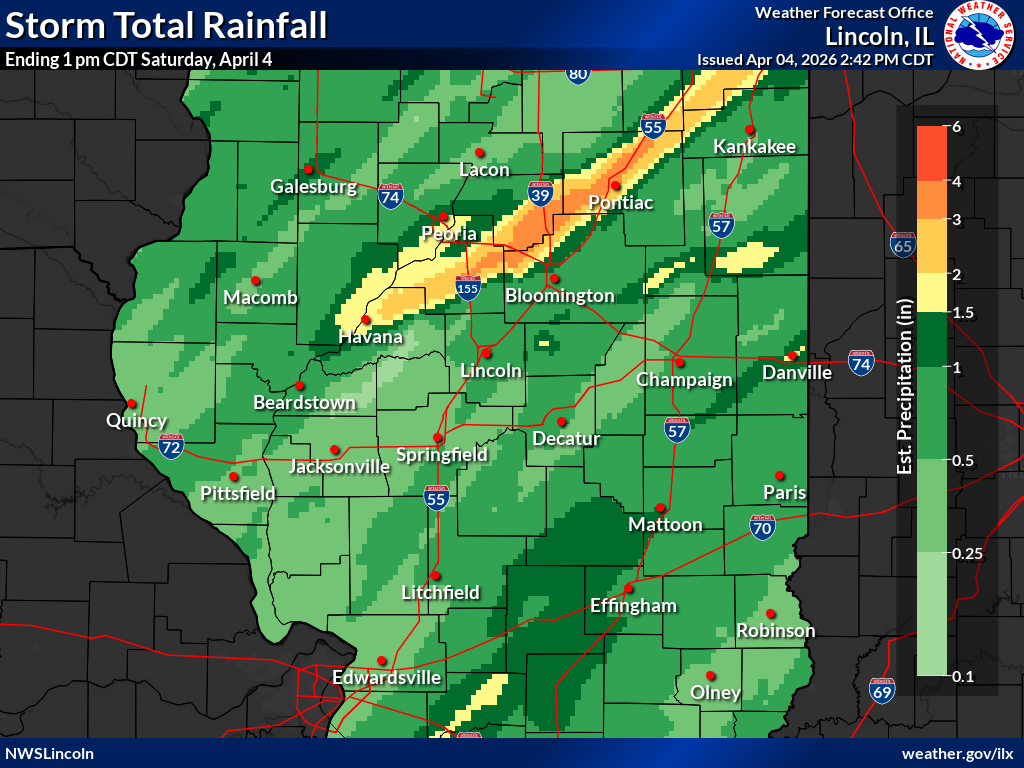 |
...24-HOUR PRECIPITATION REPORTS APR 3-4... Location Amount Time/Date Provider Congerville 0.6 WSW 3.27 in 0700 AM 04/04 COCORAHS PEORIA 2.90 in 0740 AM 04/04 CWOP Congerville 2.81 in 0906 PM 04/03 Emergency Mngr 2 N Panola 2.72 in 0735 AM 04/04 AWS Goodfield 2.50 in 0735 AM 04/04 CWOP 3 NW Hopedale 2.43 in 0730 AM 04/04 COCORAHS 4 NNW Hopedale 2.26 in 0854 PM 04/03 NWS Employee 2 NW Peoria 2.25 in 0845 PM 04/03 Pekin 2.21 in 0739 AM 04/04 CWOP Peoria Intl Arpt 2.18 in 0737 AM 04/04 ASOS Carlock 2.1 NNE 2.07 in 0600 AM 04/04 COCORAHS GERMANTOWN HILLS 1.65 in 0730 AM 04/04 CWOP Lewistown 1.65 in 0739 AM 04/04 CWOP Washington 2.0 NNW 1.61 in 0715 AM 04/04 COCORAHS Eureka 1.61 in 0735 AM 04/04 CWOP Germantown Hills 0.5 SSW 1.58 in 0700 AM 04/04 COCORAHS 1 SSW Germantown Hills 1.58 in 0713 AM 04/04 Morton 1.57 in 0700 AM 04/04 COCORAHS East Peoria 6.9 NNE 1.56 in 0700 AM 04/04 COCORAHS Washington 2.1 NW 1.46 in 0700 AM 04/04 COCORAHS Bryant 0.1 ENE 1.43 in 0510 AM 04/04 COCORAHS Canton 1.2 ESE 1.42 in 0700 AM 04/04 COCORAHS Henry 1.36 in 0736 AM 04/04 CWOP Metamora 1.1 WNW 1.33 in 0737 AM 04/04 COCORAHS East Peoria 1.32 in 0739 AM 04/04 CWOP Washington 1.26 in 0730 AM 04/04 CWOP Washington 1.25 in 0731 AM 04/04 CWOP Pekin 1.23 in 0730 AM 04/04 CWOP 1 NW Metamora 1.21 in 0735 AM 04/04 CWOP Danville 1.19 in 0736 AM 04/04 CWOP Danville 1.12 in 0601 AM 04/04 COCORAHS Roanoke 1.06 in 0700 AM 04/04 COOP Galesburg Arpt 1.05 in 0715 AM 04/04 AWOS Galesburg 1.02 in 0700 AM 04/04 COOP Washington 1.7 NE 1.00 in 0700 AM 04/04 COCORAHS |
Photos & Video
Header
| Caption (source) |
Caption (source) |
Caption (source) |
Caption (source) |
Header
| Caption (source) |
Caption (source) |
Caption (source) |
Caption (source) |
Radar
Header
| Caption | Caption | Caption | Caption |
Header
| Caption | Caption | Caption | Caption |
Environment
Insert synoptic summary.
| Figure 1: Caption | Figure 2: Caption | Figure 3: Caption |
Near-storm environment summary.
| Figure 4: Caption | Figure 5: Caption | Figure 6: Caption |
Additional environmental data.
| Figure 7: Caption | Figure 8: Caption | Figure 9: Caption |
 |
Media use of NWS Web News Stories is encouraged! Please acknowledge the NWS as the source of any news information accessed from this site. |
|

