Overview
|
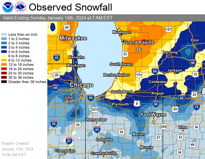
On January 12-13, a strong low pressure system impacted the area with heavy snow, heavy rain, strong gusty winds in excess of 50 mph, and impacts to travel. Many roads becoming slick and snow covered for the Friday evening commute. A flash freeze and patchy blowing snow further degraded road conditions Saturday morning. All in all, snow amounts of 2" to 4", with one reported 6" total, were recorded on January 12th. Lake effect snow continued through the 14th, especially for Berrien and Cass counties in Michigan. Arctic air followed the winter storm, with wind chills as low as -15 to -25 degrees for several days. |
Snow Totals
The initial onset of precipitation on the morning of January 12th was mainly snow, before precipitation transitioned to heavy rain south of US 30. A mix of rain and snow persisted north of US 30, before precipitation changed back to snow (heavy at times) in the afternoon. The rain/snow line set up right through Fort Wayne, IN; areas on the south side of town saw 0-0.5" of snow while areas on the north side of town saw totals near 2". Lake effect snow began early January 13th and added several more inches to totals, especially in far southwest Michigan. As of 1 AM EST January 16th, an estimated 19 inches of snow fell in Coloma, MI and 16.2 inches fell in Shoreham, MI in Berrien County from the 12th to the 15th!
...SNOWFALL REPORTS...

Location                     Amount    Time/Date       Lat/Lon

...Indiana...

...Allen County...
Fort Wayne 10.4 N            1.6 in    0700 AM 01/14   41.22N/85.14W
3 ENE Wallen                 1.3 in    0845 AM 01/13   41.18N/85.12W
Fort Wayne 4.1 NE            1.2 in    0700 AM 01/14   41.12N/85.09W

...Cass County...
Young America                3.0 in    0800 AM 01/14   40.57N/86.33W

...Blackford County...
(KA9VIS) Hartford City 0.7 N 1.0 in    0700 AM 01/14   40.46N/85.37W

...De Kalb County...
Ashley                       5.5 in    1100 AM 01/14   41.51N/85.13W
0.6 S Garrett                2.0 in    0730 AM 01/14   41.34N/85.13W

...Elkhart County...
Goshen 3.0 WSW               7.7 in    0700 AM 01/14   41.56N/85.88W
Goshen 4.6 N                 6.8 in    0700 AM 01/14   41.64N/85.83W
1 ESE Dunlap                 5.4 in    0700 AM 01/14   41.63N/85.90W
Goshen 0.3 NE                3.5 in    0900 AM 01/14   41.58N/85.83W
Wakarusa 2.4 NNE             3.5 in    0700 AM 01/14   41.57N/85.99W
Goshen 1.2 SW                3.3 in    0700 AM 01/14   41.57N/85.85W

...Fulton County...
Akron                        1.5 in    1140 AM 01/12   41.04N/86.03W
Rochester 2.4 NW             1.3 in    0700 AM 01/13   41.09N/86.23W

...Grant County...
(KC9QCJ) Shamrock Lakes 3.0  1.2 in    0700 AM 01/14   40.45N/85.45W

...Huntington County...
Huntington 0.3 W             3.2 in    0700 AM 01/14   40.88N/85.51W

...Jay County...
(KC9LQY) Portland 5.4 SW     0.3 in    0700 AM 01/14   40.39N/85.06W

...Kosciusko County...
North Webster 2.3 N          5.3 in    0700 AM 01/14   41.36N/85.70W
Leesburg 6.7 ESE             5.1 in    0700 AM 01/14   41.31N/85.72W
Milford 0.9 N                4.0 in    0700 AM 01/14   41.42N/85.85W
Leesburg 0.1 WNW             3.5 in    0700 AM 01/14   41.33N/85.85W
Warsaw 3.7 E                 3.3 in    0730 AM 01/14   41.23N/85.78W
Warsaw 3.0 SE                3.2 in    0800 AM 01/14   41.21N/85.80W

...La Porte County...
0.8 W La Porte              11.2 in    0700 AM 01/14   41.61N/86.73W
La Porte 1.6 SW              7.1 in    0800 AM 01/14   41.59N/86.73W
Waterford                    5.5 in    0105 PM 01/13   41.67N/86.84W
Mill Creek 1.9 NNE           7.1 in    0730 AM 01/14   41.61N/86.52W

...Marshall County...
Plymouth 2.5 WSW             3.0 in    0500 AM 01/14   41.33N/86.36W

...Miami County...
Denver 0.5 SSE               0.4 in    0700 AM 01/14   40.86N/86.07W
Denver 1.3 NE                0.4 in    0800 AM 01/14   40.88N/86.06W

...Noble County...
Kendallville 4.5 NW          4.0 in    0700 AM 01/14   41.50N/85.31W
Albion 3.7S                  2.7 in    0700 AM 01/14   41.34N/85.41W
Albion 0.5 N                 1.8 in    0600 AM 01/14   41.40N/85.42W

...St. Joseph County...
New Carlisle                 7.6 in    0430 AM 01/14   41.71N/86.50W
Granger 1.8 ENE              7.5 in    0700 AM 01/14   41.75N/86.11W
1 N Georgetown               6.8 in    0115 PM 01/13   41.75N/86.23W
2 WNW Roseland               6.6 in    0118 PM 01/13   41.73N/86.29W
2 SSE Indian Village         6.5 in    0430 PM 01/13   41.69N/86.23W
Mishawaka 3.9 ENE            6.3 in    0740 AM 01/14   41.68N/86.10W
South Bend 4.6 SE            6.0 in    0800 AM 01/14   41.62N/86.22W
South Bend 3.3 SE            5.8 in    0800 AM 01/14   41.64N/86.23W
1 S Roseland                 4.1 in    0700 AM 01/13   41.71N/86.25W

...Steuben County...
2 ENE Salem Center           5.2 in    1151 AM 01/13   41.59N/85.11W
Angola 4.1 N                 4.8 in    0545 AM 01/14   41.70N/84.99W
Angola                       4.6 in    0630 AM 01/14   41.64N/84.99W
Hudson 4.6 N                 4.1 in    0715 AM 01/14   41.60N/85.09W

...White County...
5.6 N Badger Grove           0.8 in    0700 AM 01/13   40.67N/86.95W

...Whitley County...
Columbia City 4.6 S          3.4 in    0600 AM 01/14   41.09N/85.47W
Columbia City 0.5 WSW        1.8 in    0630 AM 01/14   41.16N/85.49W
Tri-Lakes 3.0 N              1.5 in    0745 AM 01/14   41.26N/85.49W

...Michigan...

...Berrien County...
Shoreham 2.0 SE              9.5 in    0800 AM 01/14   42.03N/86.49W
Buchanan 1.4 ESE             7.2 in    0700 AM 01/14   41.82N/86.34W
St. Joseph 2.8 SSE           7.1 in    0700 AM 01/14   42.06N/86.47W
Niles 2.7 W                  6.5 in    0800 AM 01/14   41.84N/86.30W
St. Joseph 1.5 SSE           6.6 in    0700 AM 01/14   42.08N/86.48W
Stevensville 1.7 SSE         5.4 in    0800 AM 01/14   41.99N/86.51W

...Branch County...
Coldwater                    2.0 in    0500 PM 01/12   41.94N/85.00W

...Cass County...
3.0 NNW Edwardsburg          4.5 in    0700 AM 01/14   41.84N/86.10W

...Hillsdale County...
Osseo 2.7 NE                 6.0 in    0925 AM 01/13   41.90N/84.49W
Litchfield 0.3 ENE           5.1 in    0715 AM 01/14   42.05N/84.75W

...St. Joseph County...
Three Rivers 2.4 NE          6.9 in    0700 AM 01/14   41.97N/85.60W
2 E Mottville                4.3 in    1059 AM 01/13   41.80N/85.72W

...Ohio...

...Allen County...
Lima 2.7 NE                  1.0 in    0700 AM 01/14   40.77N/84.08W

...Fulton County...
Swanton 4.0 S                3.3 in    0800 AM 01/13   41.53N/83.91W

...Henry County...
Napoleon 1.2 SSE             4.0 in    0700 AM 01/14   41.38N/84.12W
Napoleon 0.6 WSW             2.1 in    0800 AM 01/14   41.39N/84.14W

...Putnam County...
Ottawa 1.0 N                 1.3 in    0700 AM 01/14   41.04N/84.04W

...Van Wert County...
Van Wert                     0.5 in    0443 PM 01/12   40.87N/84.58W

Observations are collected from a variety of sources with varying
equipment and exposures. We thank all volunteer weather observers
for their dedication. Not all data listed are considered official.

$$
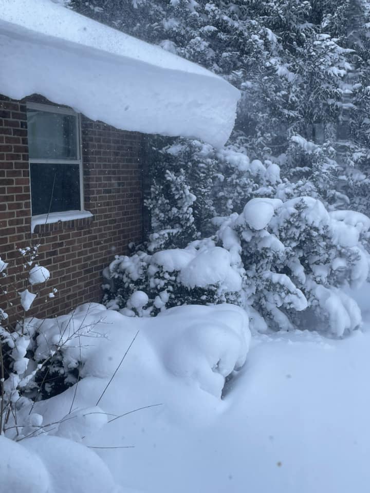
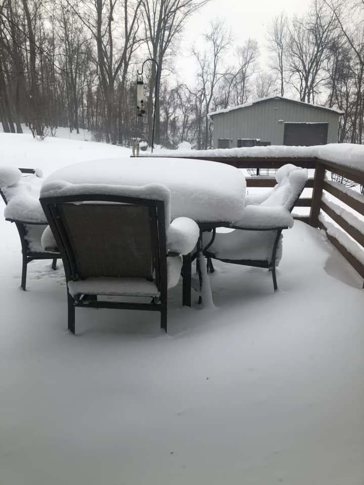
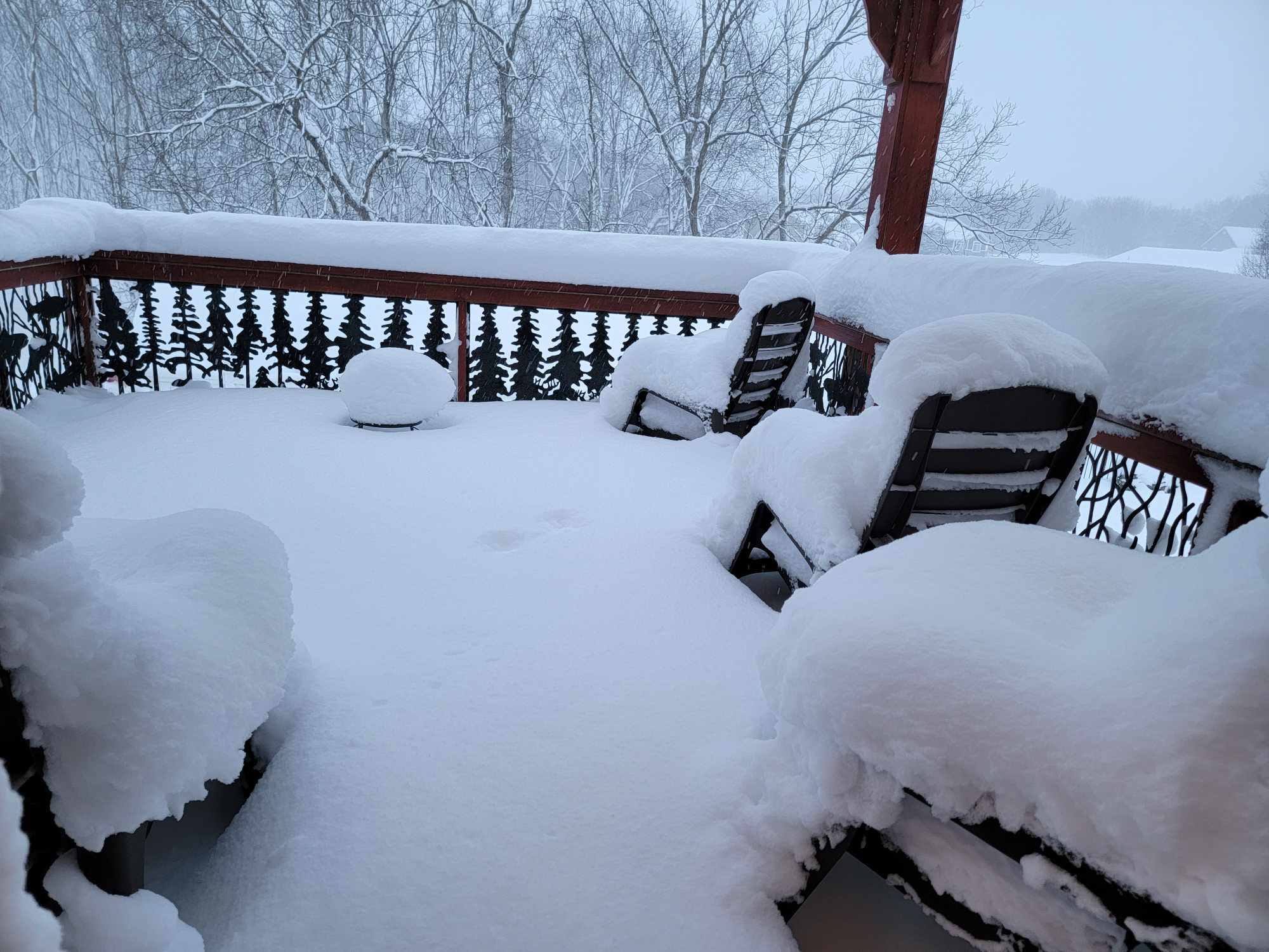
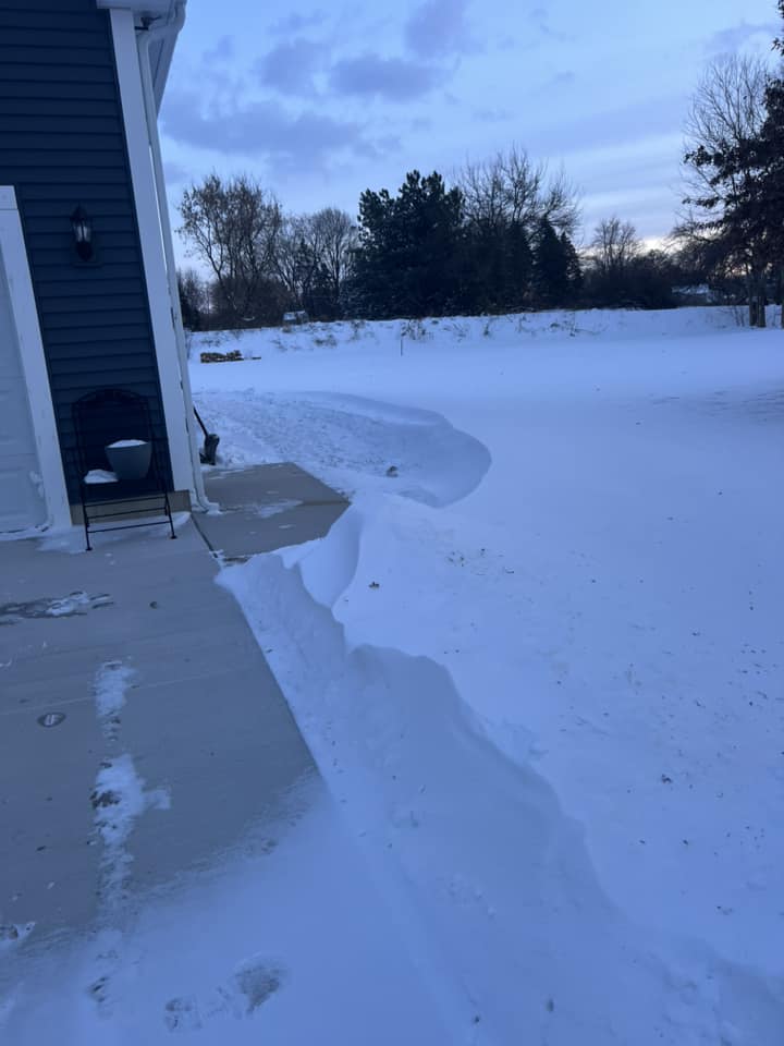
Photos & Video
| Heavy snow in New Buffalo, MI. 3am EST January 13. (Nathan Voytovick) |
 |
 |
 |
 |
| Heavy snow falling at the Fort Wayne International Airport on January 12th. (KFWA observer) |
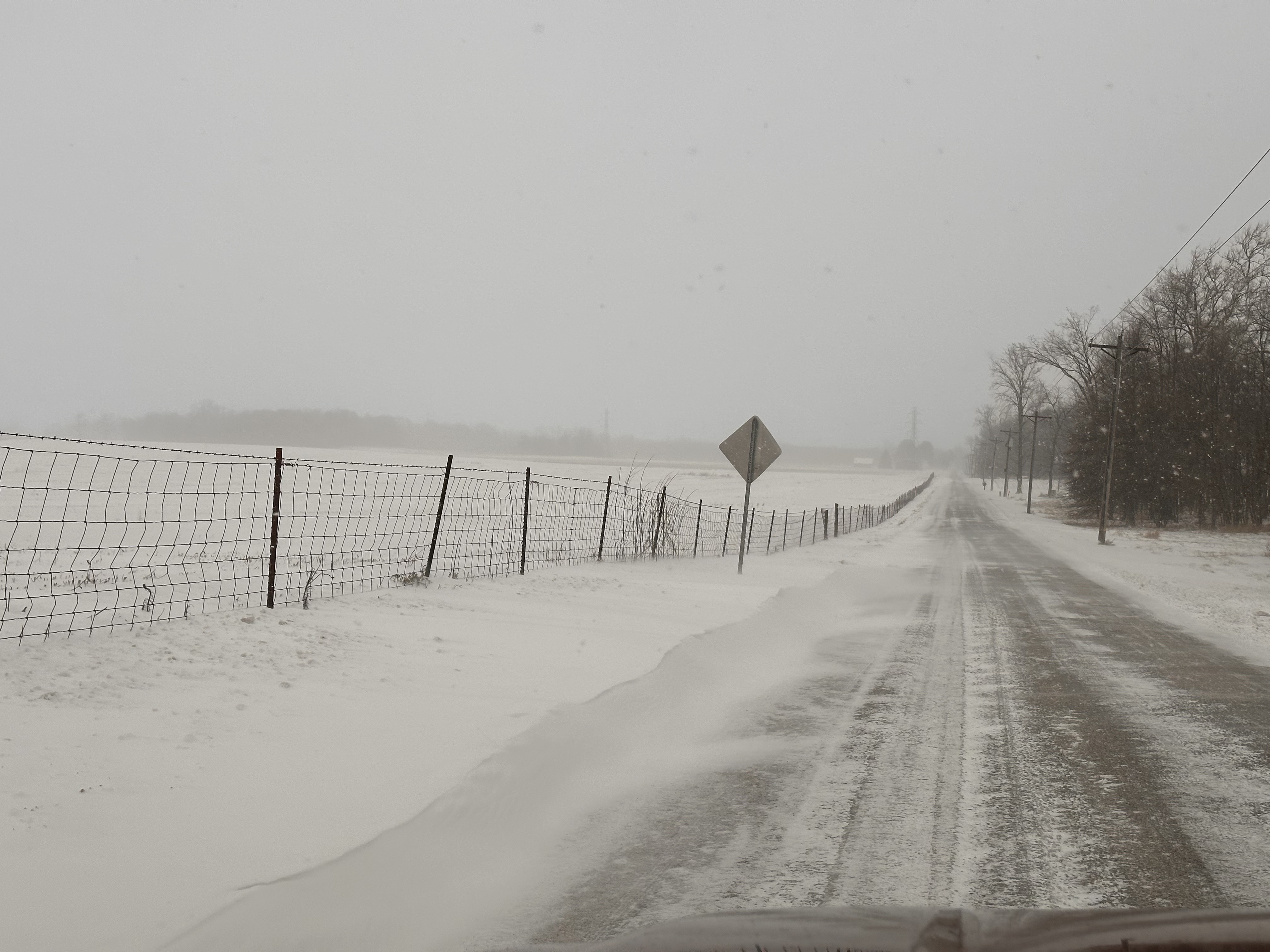
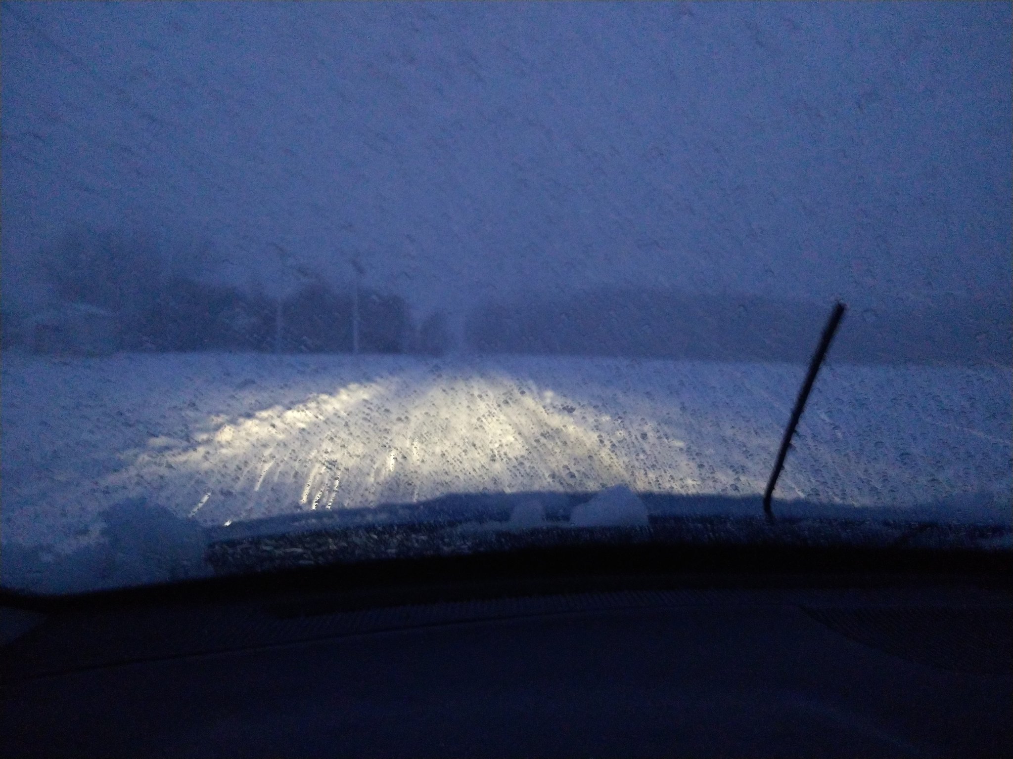
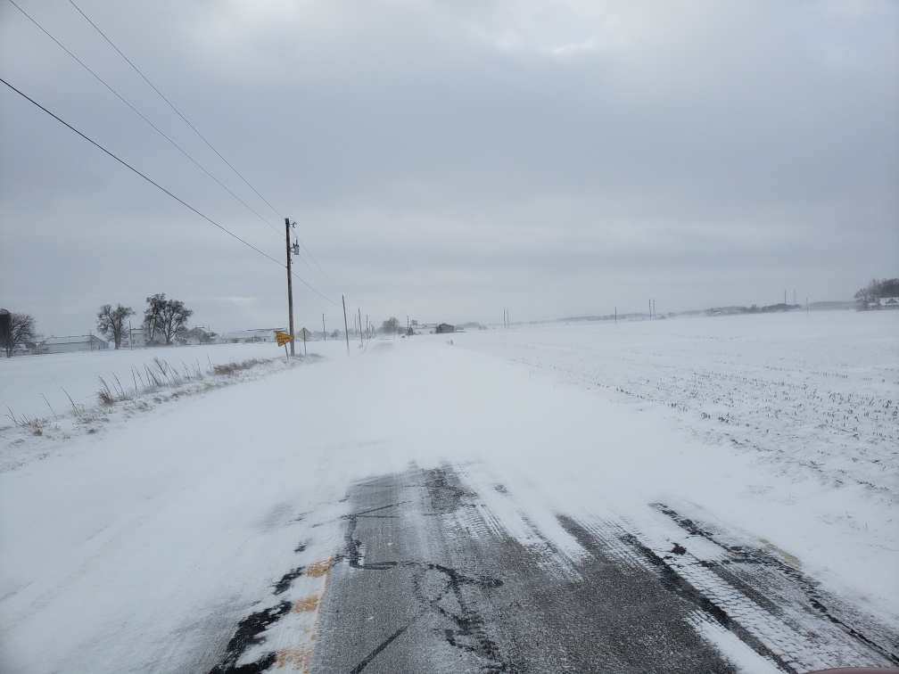
Strong winds caused blowing and drifting snow on reginal roadways. Taken the morning of 1/13. (NWS IWX, T.) |
Roadway conditions deteriorated quickly the night of 1/12. (Ben Kessler) |
Snow covered roads on IN 19 near Etna Green, 1/13. (Michael Skipper) |
 |
 |
 |
 |
| Over a foot of snow fell in Coloma, Michigan! (Rebecca Jo) |
Impressive snow accumulations in Baroda, MI (Michelle Nitz Schafer) |
Snow on a patio in Coloma, Michigan taken on 1/16. (Kathy Rennhack) |
Snow drifts in St Joe, MI where an estimated 15 inches fell in 3 days. (Ryan Lynch) |
Radar
January 12, 2024
| Radar loop from about 5am EST 1/12 through 11am EST. This heavy burst of snow, with rates near 1" per hour, quickly covered the roadways. (NOAA) |
| Radar loop from about 12pm EST 1/12 through 6pm EST. Due to precipitation type limitations in this algorithm, this radar loop depicts more rain than what was actually observed; especially toward the Michigan state line. Snow transitioned to rain by midday, but then back to snow in others. This resulted in variable travel conditions from north to south. (NOAA) |
Wind Reports
Public Information Statement
National Weather Service Northern Indiana
152 PM EST Sat Jan 13 2024

...HIGHEST WIND REPORTS PAST 24 HOURS...

Location                     Speed     Time/Date       Lat/Lon

...Indiana...

...Adams County...
Decatur                      45 MPH    0155 AM 01/13   40.76N/85.06W

...Allen County...
Fort Wayne International Ap  54 MPH    0350 AM 01/13   40.98N/85.18W
1 SE Wallen                  40 MPH    1135 AM 01/13   41.15N/85.15W
Spencerville                 36 MPH    0945 AM 01/13   41.25N/84.89W

...Cass County...
Dunkirk                      50 MPH    1100 PM 01/12   40.76N/86.39W
Logansport                   45 MPH    0755 AM 01/13   40.72N/86.37W
Walton                       39 MPH    0245 AM 01/13   40.66N/86.22W
Galveston                    37 MPH    1215 AM 01/13   40.56N/86.19W

...De Kalb County...
Garrett                      41 MPH    0305 AM 01/13   41.33N/85.13W
Auburn Dekalb C              40 MPH    0355 AM 01/13   41.30N/85.07W
Spencerville                 37 MPH    0925 AM 01/13   41.28N/84.88W
Hamilton                     36 MPH    1015 AM 01/13   41.50N/84.94W

...Elkhart County...
Goshen                       52 MPH    0240 AM 01/13   41.53N/85.78W
Elkhart Municipa             37 MPH    1022 PM 01/12   41.72N/86.00W

...Fulton County...
Rochester                    47 MPH    1135 PM 01/12   41.07N/86.18W
Kewanna                      44 MPH    0745 AM 01/13   40.94N/86.43W

...Huntington County...
Huntington                   44 MPH    0238 AM 01/13   40.83N/85.53W
Lafontaine                   36 MPH    1125 PM 01/12   40.70N/85.50W

...Jay County...
1 N Portland                 45 MPH    0535 AM 01/13   40.45N/84.98W

...Kosciusko County...
Warsaw Muni                  39 MPH    1055 PM 01/12   41.27N/85.83W

...La Porte County...
La Porte                     43 MPH    0435 AM 01/13   41.57N/86.73W

...Marshall County...
Plymouth Site KC65           39 MPH    1115 PM 01/12   41.37N/86.30W

...Miami County...
Grissom AFB Peru             52 MPH    1259 AM 01/13   40.63N/86.15W
Amboy                        43 MPH    0145 AM 01/13   40.59N/85.98W

...Noble County...
Kendallville                 41 MPH    1255 AM 01/13   41.47N/85.25W

...St. Joseph County...
South Bend International Ap  46 MPH    1216 AM 01/13   41.70N/86.32W

...Starke County...
Knox - Starke Co. Airport    39 MPH    0815 PM 01/12   41.33N/86.67W

...Steuben County...
Angola                       47 MPH    0115 AM 01/13   41.63N/85.08W

...Wabash County...
North Manchester             41 MPH    0526 AM 01/13   41.00N/85.77W
Wabash                       38 MPH    1245 AM 01/13   40.89N/85.92W

...Wells County...
Criagville                   37 MPH    1055 AM 01/13   40.78N/85.09W

...White County...
Monticello - White County Ar 45 MPH    1115 PM 01/12   40.72N/86.77W
Chalmers                     35 MPH    0120 AM 01/13   40.69N/86.92W

...Whitley County...
Northeast Purdue Agricultura 50 MPH    0230 AM 01/13   41.11N/85.40W

...Michigan...

...Berrien County...
Benton Harbor                49 MPH    0505 AM 01/13   42.13N/86.42W
I94mm0419                    42 MPH    0725 AM 01/13   42.18N/86.24W
Saint Joseph                 41 MPH    0600 AM 01/13   42.10N/86.49W
I94mm0372                    40 MPH    1028 AM 01/13   42.17N/86.33W
2.0 W Spinks Corners (MAWN)  38 MPH    0500 AM 01/13   42.08N/86.36W

...Branch County...
Coldwater                    40 MPH    0215 AM 01/13   41.92N/85.03W

...Hillsdale County...
Hillsdale                    37 MPH    0115 PM 01/13   41.92N/84.58W

...St. Joseph County...
Sturgis Kirsch               46 MPH    1255 AM 01/13   41.80N/85.43W
Three Rivers                 38 MPH    1215 PM 01/13   41.97N/85.60W

...Ohio...

...Allen County...
Lima                         52 MPH    0621 AM 01/13   40.70N/84.02W
Lima 1 N                     46 MPH    1026 AM 01/13   40.78N/84.12W
Bluffton                     44 MPH    0715 AM 01/13   40.89N/83.89W
Pandora                      40 MPH    1235 PM 01/13   40.92N/83.97W

...Defiance County...
Defiance                     48 MPH    0959 AM 01/13   41.33N/84.43W
Hicksville                   39 MPH    1145 AM 01/13   41.26N/84.73W

...Fulton County...
Wauseon                      45 MPH    0515 AM 01/13   41.62N/84.13W
Delta                        44 MPH    0805 AM 01/13   41.51N/84.04W
Fayette                      35 MPH    0455 AM 01/13   41.63N/84.23W

...Henry County...
Defiance                     39 MPH    1215 PM 01/13   41.20N/84.20W
Napoleon                     37 MPH    1105 AM 01/13   41.46N/84.15W

...Paulding County...
Antwerp                      36 MPH    0915 AM 01/13   41.12N/84.70W
Payne                        35 MPH    0330 AM 01/13   41.06N/84.69W

...Putnam County...
Ottawa                       47 MPH    0415 AM 01/13   41.03N/83.98W
Kalida                       43 MPH    1230 PM 01/13   40.98N/84.20W
Vaughnsville                 42 MPH    1025 AM 01/13   40.88N/84.15W

...Van Wert County...
Scott                        46 MPH    0925 AM 01/13   40.99N/84.58W
Van Wert                     40 MPH    0536 AM 01/13   40.87N/84.59W
Middle Point                 39 MPH    0539 AM 01/13   40.86N/84.45W
Environment
 |
 |
.jpg) |
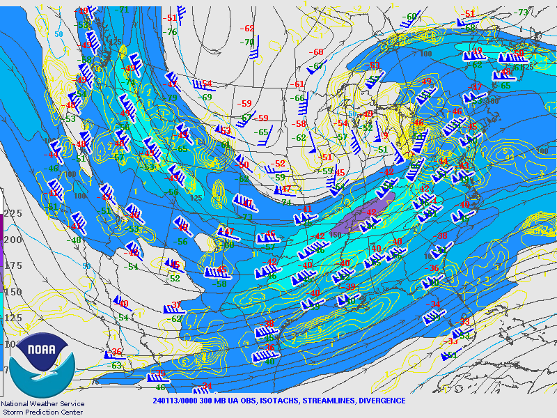
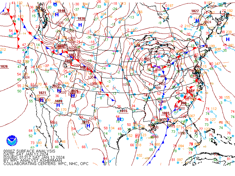
| Figure 1: 300 mb heights/winds upper level chart for 1/12 at 7pm EST. A strong 150 knot upper jet streak across the Ohio Valley contributed to the strength of this system. | Figure 2: Sfc pressure and fronts map for 1/12 at 7pm EST. Strong low pressure across southern Great Lakes and high pressure east of the Rockies led to very strong winds. | Figure 3: 850mb moisture transport map for 1/12 at Noon EST. |
 |
 |
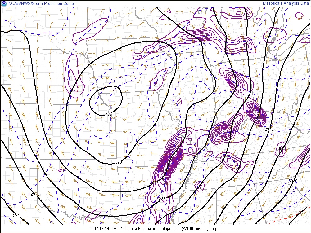 |
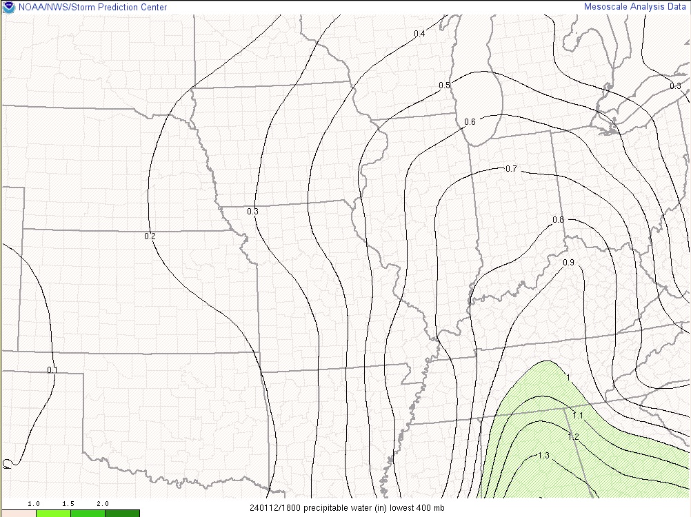
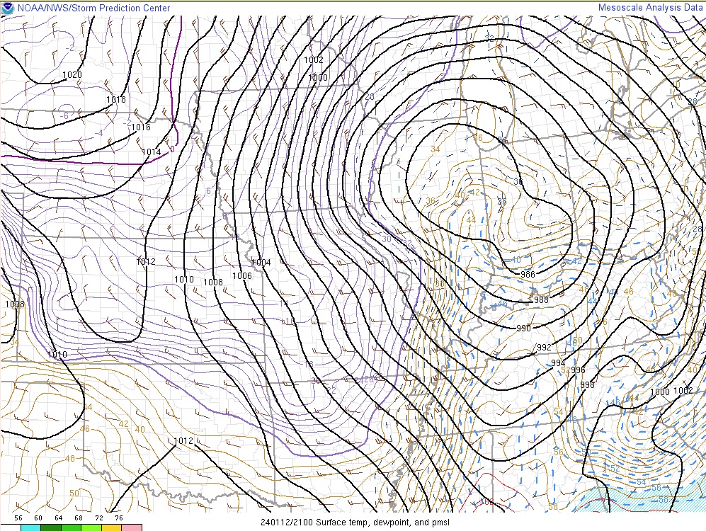
| Figure 4: Precipitable water map measured in inches for lowest 400mb for 1/12 at 1pm EST . | Figure 5: Surface temperature, dew point, and mean sea level pressure map on 1/12 at 4pm EST. | Figure 6: 700mb Petterssen frontogenesis map for 1/12 at 9am EST. |
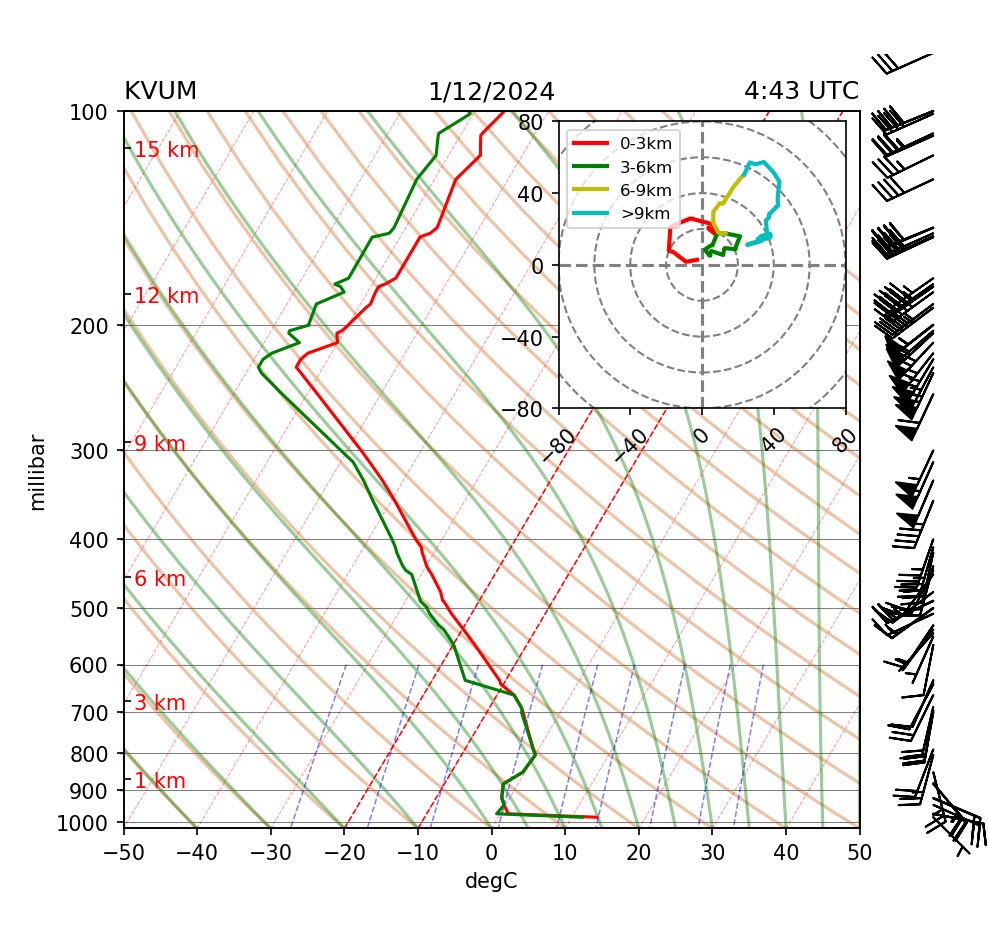 |
| Figure 7: KVUM (Valparaiso University in Indiana) upper air sounding for the evening of 1/11 at 1145pm EST. |
 |
Media use of NWS Web News Stories is encouraged! Please acknowledge the NWS as the source of any news information accessed from this site. |
|

