Northern Indiana
Weather Forecast Office
February 25-27 Snowstorm
A potent upper level low pressure system ejecting out of the southwestern U.S. on the 25th induced intensifying surface low pressure over the southern Missippi Valley which then lifted northeast into western Ohio on the 26th and then into Ontario Canada by the 27th. As this system deepened rapidly, arctic high pressure built southward across the western Lakes with heavy lake effect snow developing during the afternoon of the 26th and which continued into the 27th.
Moderate to heavy snow was widespread across northern Indiana and southwest Michigan with lighter amounts over northwest Ohio. Total snowfall amounts across the area ranged from 6 to 17 inches. The heaviest synoptic snowfall occurred over Kosciusko and Noble counties where a foot was measured at the NWS office and 9 inches reported in Warsaw. Additional lake effect added to the totals over northwest Indiana and southwest Michigan with 16.7 inches reported at the South Bend Airport and where daily snowfall records were broken for the 26th and 27th.
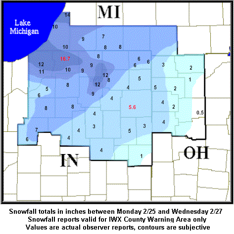
Click for a list of reported storm total snowfall amounts across the area...
PUBLIC INFORMATION STATEMENT
NATIONAL WEATHER SERVICE NORTHERN INDIANA
355 PM EST WED FEB 27 2002

STORM TOTAL SNOWFALL OVER NORTHERN INDIANA...EXTREME SOUTHERN LOWER
MICHIGAN...AND NORTWEST OHIO SINCE MONDAY AFTERNOON.


...SNOWFALL TOTALS THROUGH 100 PM EST...

SOUTH BEND AIRPORT          16.7 INCHES
FORT WAYNE AIRPORT           5.6 INCHES
NWS OFFICE IN SYRACUSE      12.0 INCHES


...SNOWFALL TOTALS THROUGH 800 AM EST...

LOCATION        STATE   COUNTY      AMOUNT

WATERVLIET      MI      BERRIEN     11-12 INCHES
LOGANSPORT      IN      CASS        1-2 INCHES
CASSOPOLIS      MI      CASS        6-7 INCHES
HICKSVILLE      OH      DEFIANCE    4-5 INCHES
AUBURN          IN      DEKALB      4-5 INCHES
ELHKART         IN      ELKHART     8-9 INCHES
GOSHEN          IN      ELKHART     7-9 INCHES
ROCHESTER       IN      FULTON      7-8 INCHES
WAUSEON         OH      FULTON      2-3 INCHES
MARION          IN      GRANT       3 INCHES
PORTLAND        IN      JAY         2 INCHES
WARSAW          IN      KOSCIUSKO   9 INCHES
KINGSBURY       IN      LAPORTE     11-12 INCHES
LAPORTE         IN      LAPORTE     10-11 INCHES
PLYMOUTH        IN      MARSHALL    8 INCHES
PERU            IN      MIAMI       4 INCHES
KENDALLVILLE    IN      NOBLE       3 INCHES
PAULDING        OH      PAULDING    4 INCHES
WINAMAC         IN      PULASKI     8 INCHES
MISHAWAKA       IN      ST. JOSEPH  11 INCHES
LAKEVILLE       IN      ST. JOSEPH  8 INCHES
STURGIS         MI      ST. JOSEPH  8 INCHES
KNOX            IN      STARKE      4-5 INCHES
ANGOLA          IN      STEUBEN     6 INCHES
VAN WERT        OH      VAN WERT    4 INCHES
WABASH          IN      WABASH      2-3 INCHES
CHALMERS        IN      WHITE       6 INCHES
COLUMBIA CITY   IN      WHITLEY     4 INCHES
MONTPELIER      OH      WILLIAMS    3 INCHES
Hazards
Heat Related
Winter Related
Watch/Warning
Outlook
Storm Reports
Storm Prediction Center
Submit a Report
Event Ready
Climate
FWA Daily
SBN Daily
FWA Monthly
SBN Monthly
CoCoRaHS
Spring Frost Climatology
Fall Frost Climatology
Severe Climatology
Local Information
Skywarn
COOP
Our Office
WSR-88D
Headline Criteria
NOAA Weather Radio
Weather History
Probabilistic Snowfall
Public Information Statement
Social Media Feeds
Weather Events Page
US Dept of Commerce
National Oceanic and Atmospheric Administration
National Weather Service
Northern Indiana
7506 E 850 N
Syracuse, IN 46567
574-834-1104
Comments? Questions? Please Contact Us.

