Snow and Wind Sweep Through the Area
Storm Was Forecast Well in Advance by NWS Meteorologists
On Saturday, February 22, 2003, a snowstorm swept across northeast Indiana and northwest Ohio, depositing up to 11 inches of snow. North winds gusting to nearly 40 mph accompanied the snow. The precipitation started out as freezing rain in some southeastern sections of the area.
Five days before the storm, on Monday, WFO Northern Indiana sent out a Hazardous Weather Outlook (HWO) that included a mention of the possibility of accumulating snow on Saturday. Similar HWO's were issued on Tuesday, Wednesday, and Thursday.
The Thursday morning HWO mentioned "portions of the region could experience significant snow accumulations." The HWO was updated that afternoon to include the possibility of freezing rain. The Friday morning HWO said "there is a potential for heavy snow accumulations." The morning of the storm, the HWO got even more specific, stating that the heaviest accumulations would fall that day "east of a Monticello Indiana to Hillsdale Michigan line."
The forecast (ZFP) mentioned a chance of snow on Saturday as early as the previous Saturday, February 15, and remained in the forecast as the week progressed. The chance of snow was also mentioned in the Area Forecast Discussion (AFD) a full week in advance on the previous Saturday.
A Winter Storm Watch (WSW) was posted at 4:00am Friday, and was upgraded to a Winter Storm Warning (WSW) in the southeast sections and a Winter Weather Advisory (WSW) in the northwest at 4:45am Saturday. Forecast snowfall accumulations ranged from about an inch in the far northwest (outside of the advisory) to as much as 8 inches in the southeast.
Snowfall map (click on the map for a larger version).
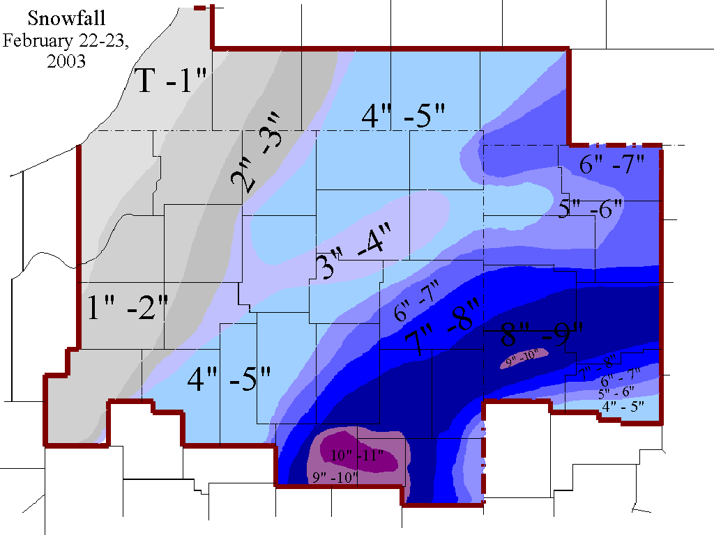
Note: due to the precipitation beginning as rain and mixing with sleet and freezing rain, and 20 to 40 mph winds as the snow fell, measurements were difficult to take. As a result, totals on this map may not exactly match with what you measured in your own front yard.

