Severe thunderstorms smack portions of the area July 26, 2005
Several rounds of thunderstorms occurred across the area on the 26th. Some of these storms reached severe levels with some significant damage noted, especially during the evening hours. One F2 tornado occurred during this event in extreme eastern Cass county and extreme western Miami county in north central Indiana.
Synoptic Conditions
An unstable atmosphere was in place across the forecast area much of the day. Surface temperatures in the 80s and dewpoints in the 70s allowed for lifted indices (LI's) to drop into the -5 to -7 C range, with surface based CAPE running from 2000 J/kg to as much as 4000 J/kg. Moisture convergence along the pre-frontal trough was allowing for a large pool of 75 to 77 degree dewpoints on the trough. A mid level cap was in place through much of the afternoon, but was able to weaken sufficiently to allow for convection to fire during the afternoon hours. Mid level winds of greater than 60 to 80 knots were observed for the storms to transport to the surface, with low level winds in the 30 to 40 knots range, allowing for sufficient deep layer shear to develop and sustain organized severe thunderstorms. Freezing levels during the event were very high, around 15,000 feet, which would only allow for hail with the strongest updrafts. Conditions evolved into a somewhat more favorable setup for severe weather into the evening hours.
During the evening, while much of the northern half of the forecast area had seen a large amount of thunderstorm activity and had much of the potential energy used already, locations in the south, especially southwest parts of the forecast area, remained unstable with a Lifted Index in the -3 to -5 C range. A shortwave entering the region, enhanced the lift and allowed for the cap to weaken much more than during the afternoon event. Numerous outflow boundaries were left over from the afternoon convection. I addition, winds near the surface backed to the southeast just ahead of an approaching line of thunderstorms that developed in Illinois. The outflow boundaries and the southeast surface wind were critical elements of the development of the F2 tornado.
Radar Observations and Interpretations
Once convection initiated and tapped the available energy, storms quickly intensified with many reaching maximum heights of 45,000 to as much as 55,000 feet. Strong updrafts allowed for cores of higher reflectivites to exist and maintain themselves above the freezing level, with velocity data indicating the potential for winds in excess of 70 mph (mid level winds of 60-80 knots with low level winds of 30 to 40 knots). Additional storms continued to develop along the pre-frontal trough as well as from interactions with numerous outflow boundaries from past storms.
During the late afternoon and early evening hours, a line of strong to severe storms developed on the main cold front in response to increasing large scale lift from the approaching mid level shortwave. One part of the line in particular, caused several reports of 60 mph wind gusts and some damage with several mid level mesocyclones being noted as it moved east into Indiana during the evening hours. A Line Echo Wave Pattern, or LEWP, evolved out of this line, which is a bulge in a thunderstorm line producing a wave-shaped "kink" in the line (Fig. 4). The potential for strong outflow and damaging straight-line winds increases near the bulge, which often resembles a bow echo. LEWP can also produce tornadoes if a sufficient source of low level horizontal vorticity, or spin, is present. In this case, the outflow boundaries from previous thunderstorms as well as the surface winds backed to the southeast provided that low level source of horizontal vorticity. Several radar images from the Chicago, Lincoln and Indianapolis NWS radars showed mesocyclones persisting along its track. Damage was noted just outside the CWA prior to the damage in the evening, with a few tornadoes being confirmed from the same complex of storms in Clinton County Indiana.
A strong mid level circulation was noted at 807 pm EST on the 1.5 degree elevation of the KIWX radar Storm Relative Motion (SRM) data as the leading edge of the storms moved into Carroll county and towards Cass and Miami county. This circulation, along with the history of the line and the presence of the remnant outflow boundaries, prompted the upgrade of the Severe Thunderstorm Warning for eastern Cass county and southern Miami county (issued at 749 pm EST) to a Tornado Warning at 812 pm EST. The initial touchdown occurred at 825 pm EST, giving a 13 minute lead time from the issuance of the Tornado Warning and a 38 minute lead time from the Severe Thunderstorm Warning. By 827 pm, the circulation is visible on the 0.5 degree SRM with gate to gate shear observed (an excellent indicator of an increasing potential for tornadic development). Spotter reports confirmed a tornado was on the ground at this time, producing damage. The associated 0.5 degree reflectivity image at the same time also showed a cell merger in progress between the line and another area of storms that had formed just ahead of the line. In the 832 pm EST 0.5 degree velocity image, a feature called the Rear Flank Downdraft (RFD) is observed on the velocity data as an area of significantly higher wind speeds. As the RFD moved quickly east it cut off the inflow of air into the tornado from the southeast and caused a rapid demise of the tornado. This feature was still visible at 837 pm. This area of wind subsequently began to weaken but not before quickly moving through parts of Wabash and Huntington counties causing damage as well. This line of storms continued rapidly east into northwestern Ohio.
BULLETIN - EAS ACTIVATION REQUESTED
SEVERE THUNDERSTORM WARNING
NATIONAL WEATHER SERVICE NORTHERN INDIANA
749 PM EST TUE JUL 26 2005

THE NATIONAL WEATHER SERVICE IN NORTHERN INDIANA HAS ISSUED A

* SEVERE THUNDERSTORM WARNING FOR...
  CASS COUNTY IN INDIANA
  EAST CENTRAL WHITE COUNTY IN INDIANA

* UNTIL 845 PM EST

* AT 747 PM EST...NATIONAL WEATHER SERVICE DOPPLER RADAR INDICATED A
  LINE OF SEVERE THUNDERSTORMS CAPABLE OF PRODUCING PENNY SIZE
  HAIL...AND DAMAGING WINDS IN EXCESS OF 60 MPH.  THESE SEVERE STORMS
  WERE LOCATED ALONG A LINE EXTENDING FROM 9 MILES NORTHWEST OF
  MONTICELLO TO 9 MILES SOUTH OF MONTICELLO TO 17 MILES SOUTH OF
  MONTICELLO...AND MOVING EAST AT 40 MPH.

* LOCATIONS IN THE PATH OF SEVERE THUNDERSTORMS INCLUDE...
  ROYAL CENTER...
  LOGANSPORT...
  DEACON...
  WALTON...
  GALVESTON...

FOR YOUR PROTECTION MOVE TO AN INTERIOR ROOM ON THE LOWEST FLOOR OF
YOUR HOME OR BUSINESS. THIS STORM HAS THE POTENTIAL TO CAUSE SERIOUS
INJURY AND SIGNIFICANT DAMAGE TO PROPERTY.

LAT...LON 4087 8676 4074 8677 4075 8652 4071 8652
      4071 8637 4058 8636 4058 8617 4089 8618

$$

FISHER
BULLETIN - EAS ACTIVATION REQUESTED
TORNADO WARNING
NATIONAL WEATHER SERVICE NORTHERN INDIANA
812 PM EST TUE JUL 26 2005

THE NATIONAL WEATHER SERVICE IN NORTHERN INDIANA HAS ISSUED A

* TORNADO WARNING FOR...
  SOUTHEASTERN CASS COUNTY IN INDIANA
  SOUTHERN MIAMI COUNTY IN INDIANA

* UNTIL 900 PM EST

* AT 807 PM EST...NATIONAL WEATHER SERVICE DOPPLER RADAR INDICATED A
  SEVERE THUNDERSTORM WITH STRONG ROTATION.  THIS SEVERE STORM WAS
  LOCATED 10 MILES SOUTHWEST OF WALTON...OR ABOUT 7 MILES NORTHEAST
  OF FLORA...AND MOVING EAST AT 60 MPH.

* LOCATIONS IN THE PATH OF THE SEVERE STORM INCLUDE...
  GRISSOM AFB...
  BUNKER HILL AND PERU...
  LINCOLN...

IN ADDITION TO THE TORNADO...THIS STORM IS CAPABLE OF PRODUCING
PENNY SIZE HAIL AND DESTRUCTIVE STRAIGHT LINE WINDS.

THE SAFEST PLACE TO BE DURING A TORNADO IS IN A BASEMENT. GET UNDER A
WORKBENCH OR OTHER PIECE OF STURDY FURNITURE. IF NO BASEMENT IS
AVAILABLE...SEEK SHELTER ON THE LOWEST FLOOR OF THE BUILDING IN AN
INTERIOR HALLWAY OR ROOM SUCH AS A CLOSET. USE BLANKETS OR PILLOWS TO
COVER YOUR BODY AND ALWAYS STAY AWAY FROM WINDOWS.

IF IN MOBILE HOMES OR VEHICLES...EVACUATE THEM AND GET INSIDE A
SUBSTANTIAL SHELTER. IF NO SHELTER IS AVAILABLE...LIE FLAT IN THE
NEAREST DITCH OR OTHER LOW SPOT AND COVER YOUR HEAD WITH YOUR HANDS.

LAT...LON 4073 8637 4058 8636 4059 8587 4066 8587
      4066 8594 4082 8594

$$

FISHER
Damage Information and other Noteworthy Items
During the afternoon thunderstorms, some damage was reported by trained spotters and county officials. A listing of this preliminary damage can be found by viewing the Local Storm Report for this event. A firefighter in Decatur who was observing the storms after hearing of the warning was indirectly struck by lightning near his house. He was transported to the hospital as a precaution but luckily he suffered no significant injuries. A house next door was also affected with 2 boys that were playing video games receiving a shock through their game controllers. No injuries were reported.
PRELIMINARY LOCAL STORM REPORT...SUMMARY
NATIONAL WEATHER SERVICE NORTHERN INDIANA
447 PM EST WED JUL 27 2005


..TIME...   ...EVENT...      ...CITY LOCATION...     ...LAT.LON...
..DATE...   ....MAG....      ..COUNTY LOCATION..ST.. ...SOURCE....
            ..REMARKS..


0120 PM     TSTM WND DMG     ANGOLA                  41.64N 85.00W
07/26/2005                   STEUBEN            IN   LAW ENFORCEMENT


            SEVERAL TREES AND POWERLINES DOWN

0130 PM     TSTM WND DMG     7 NE EDON               41.63N 84.67W
07/26/2005                   WILLIAMS           OH   LAW ENFORCEMENT


            TREE DOWN 1 NE COLUMBIA


0255 PM     TSTM WND DMG     GEORGETOWN              41.73N 86.23W
07/26/2005                   ST. JOSEPH         IN   AMATEUR RADIO

            LARGE TREE AND EMERGENCY SIREN POLE BLOWN DOWN.


0310 PM     LIGHTNING        DECATUR                 40.83N 84.93W
07/26/2005                   ADAMS              IN   EMERGENCY MNGR

            *** 1 INJ *** PERSON STRUCK BY LIGHTNING. WAS BRIEFLY
            HOSPITALIZED.


0315 PM     TSTM WND DMG     PERU                    40.75N 86.07W
07/26/2005                   MIAMI              IN   LAW ENFORCEMENT

            SEVERAL TREES AND POWERLINES DOWN.


0346 PM     TSTM WND DMG     2 NE CONVOY             40.94N 84.68W
07/26/2005                   VAN WERT           OH   AMATEUR RADIO

            SEMI TRUCK OVERTURNED ON US 30


&&
FINAL SUMMARY FOR JULY 26, 2005 AFTERNOON STORMS.
$$

FISHER
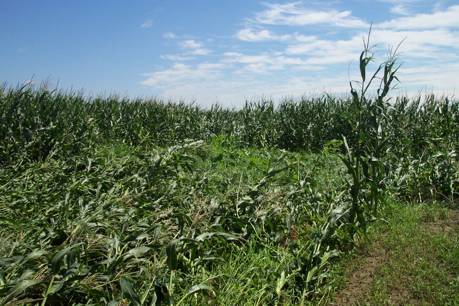
During the evening severe weather damage was more widespread, especially over the southwest portion of the area which was impacted by the aforementioned LEWP and F2 tornado. Trees and power lines were knocked down from White county east into Grant County Indiana from straight line winds. Amboy in southern Miami county received the worst straight line wind damage with many large trees down and a large building severely damaged. This area likely experienced 70 to 80 mph straight line winds as the Rear Flank Downdraft (RFD) wrapped around the south side of the storm producing the tornado farther north.
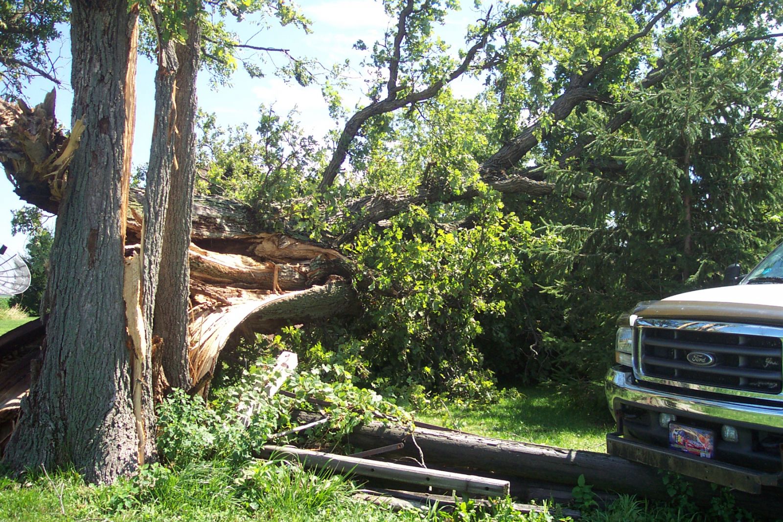
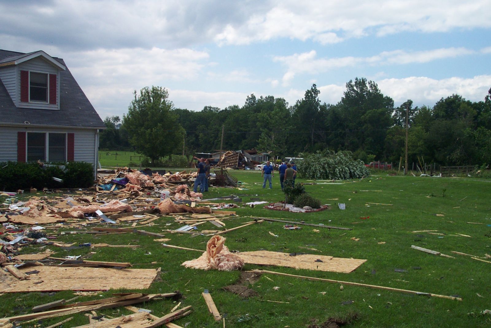
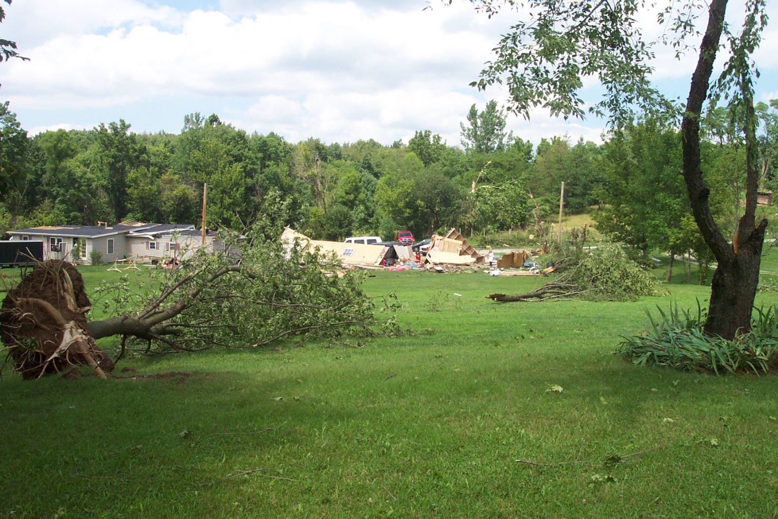
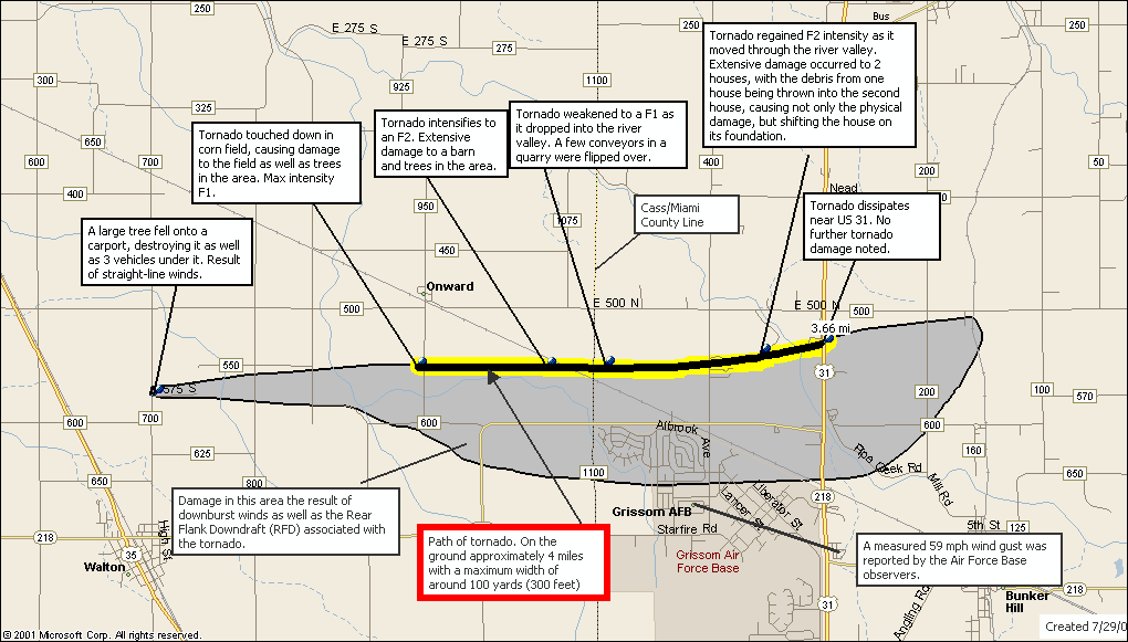
By far the worst damage was from the F2 tornado. The tornado formed over extreme eastern Cass county just south of Orland, and continued for about 4 miles into western Miami county a few miles northwest of Bunker Hill. Click HERE for a map of the tornado path. The actual tornado path is in yellow, with the light gray shaded area depicting where straight line wind damage occurred. For a detailed description of the tornado damage see the NWS Storm Survey. For a complete preliminary summary of all storm damage from the evening severe weather click HERE.
PRELIMINARY LOCAL STORM REPORT...SUMMARY
NATIONAL WEATHER SERVICE NORTHERN INDIANA
455 PM EST WED JUL 27 2005


..TIME...   ...EVENT...      ...CITY LOCATION...     ...LAT.LON...
..DATE...   ....MAG....      ..COUNTY LOCATION..ST.. ...SOURCE....
            ..REMARKS..


0655 PM     HAIL             WATERLOO                41.43N 85.03W
07/26/2005  0.75 INCH        DE KALB            IN   LAW ENFORCEMENT

0708 PM     TSTM WND DMG     5 E DENVER              40.86N 85.98W
07/26/2005                   MIAMI              IN   AMATEUR RADIO

            LARGE TREE BLOWN DOWN

0727 PM     TSTM WND DMG     WABASH                  40.80N 85.83W
07/26/2005                   WABASH             IN   LAW ENFORCEMENT

            POLES BLOWN DOWN

0740 PM     TSTM WND DMG     BROOKSTON               40.60N 86.87W
07/26/2005                   WHITE              IN   LAW ENFORCEMENT

            POWER LINES AND POLE BLOWN DOWN

0743 PM     TSTM WND DMG     2 SE BRYAN              41.45N 84.52W
07/26/2005                   WILLIAMS           OH   LAW ENFORCEMENT

            LARGE TREE BLOWN DOWN ACROSS ROAD

0743 PM     TSTM WND GST     BRYAN                   41.47N 84.55W
07/26/2005  60 MPH           WILLIAMS           OH   LAW ENFORCEMENT

0817 PM     TSTM WND GST     7 S LOGANSPORT          40.65N 86.36W
07/26/2005  70 MPH           CASS               IN   EMERGENCY MNGR

0825 PM     TORNADO          SW ONWARD               40.69N 86.20W
07/26/2005                   CASS               IN   NWS STORM SURVEY

            F2 TORNADO CONFIRMED. TOUCHDOWN AT 825 PM EST 0.7 MILES
            SW OF ONWARD. TRACK LENGTH 1 MILE TO THE MIAMI COUNTY
            LINE 1 MILE SE OF ONWARD. MAXIMUM WIDTH 100 YARDS.
            TORNADO CONTINUED INTO MIAMI COUNTY.

0825 PM     TSTM WND DMG     AMBOY                   40.60N 85.93W
07/26/2005                   MIAMI              IN   AMATEUR RADIO

            TREES AND POWER LINES DOWN

0827 PM     TORNADO          4 NW BUNKER HILL        40.70N 86.16W
07/26/2005                   MIAMI              IN   NWS STORM SURVEY

            F2 TORNADO CONFIRMED. TORNADO TOUCHED DOWN IN CASS COUNTY
            AND CROSSED INTO MIAMI COUNTY 4 MILES NW OF BUNKER HILL.
            THE TRACK LENGTH WAS 3 MILES IN MIAMI COUNTY. MAXIMUM
            WIDTH 100 YARDS.

0831 PM     TSTM WND GST     GRISSOM AFB             40.66N 86.15W
07/26/2005  59 MPH           MIAMI              IN   TRAINED SPOTTER

0846 PM     TSTM WND DMG     1 N WABASH              40.81N 85.83W
07/26/2005                   WABASH             IN   EMERGENCY MNGR

            UTILITY POLES BLOWN DOWN NORTH OF WABASH. TREE ALSO BLOWN
            DOWN NORTH OF WABASH ONTO A CAR.

0847 PM     TSTM WND DMG     10 SE WABASH            40.70N 85.69W
07/26/2005                   WABASH             IN   EMERGENCY MNGR

            TREE BLOWN DOWN ONTO POWER LINE.

0900 PM     TSTM WND DMG     MARION                  40.55N 85.67W
07/26/2005                   GRANT              IN   LAW ENFORCEMENT

            TREES REPORTED KNOCKED DOWN

0920 PM     TSTM WND DMG     1 N DECATUR             40.84N 84.93W
07/26/2005                   ADAMS              IN   EMERGENCY MNGR

            FEW TREES DOWN JUST NORTH OF DECATUR


&&
FINAL SUMMARY FOR JULY 26, 2005 EVENING STORMS. INCLUDES ADDITIONAL
REPORTS AND STORM SURVEY INFORMATION.
$$

FISHER
PUBLIC INFORMATION STATEMENT...UPDATED FOR ADDITIONAL DETAILS
NATIONAL WEATHER SERVICE NORTHERN INDIANA
522 PM EST WED JUL 27 2005
...F2 TORNADO CONFIRMED IN CASS AND MIAMI COUNTIES IN INDIANA...
A STORM SURVEY WAS COMPLETED TODAY BY THE NATIONAL WEATHER SERVICE
IN SOUTHERN CASS AND MIAMI COUNTIES IN INDIANA TO INVESTIGATE
NUMEROUS DAMAGE REPORTS. THE FOLLOWING ARE THE PRELIMINARY FINDINGS
OF THESE SURVEYS.
...TORNADO STATISTICS...
THE TOTAL DAMAGE PATH OF THE TORNADO WAS AROUND 4 MILES LONG.
MAXIMUM WIDTH WAS ABOUT 100 YARDS WIDE WITH A PRELIMINARY MAXIMUM
INTENSITY RATING OF F2 ON THE FUJITA SCALE WITH WINDS RANGING FROM
113 MPH TO 157 MPH. THE TORNADO WAS ON THE GROUND FOR AROUND 7
MINUTES WITH A TOUCHDOWN AT 825 PM EST. ABOUT 1 MILE OF THE TRACK
WAS IN CASS COUNTY WITH THE REMAINING 3 MILES IN MIAMI COUNTY.
...CASS COUNTY...
DAMAGE WAS FIRST NOTED 1 MILE NORTH OF WALTON...NEAR CR 700 E AND
550 S. THE DAMAGE CONTINUED FOR 1 MILE TO 1 MILE SW OF ONWARD...NEAR
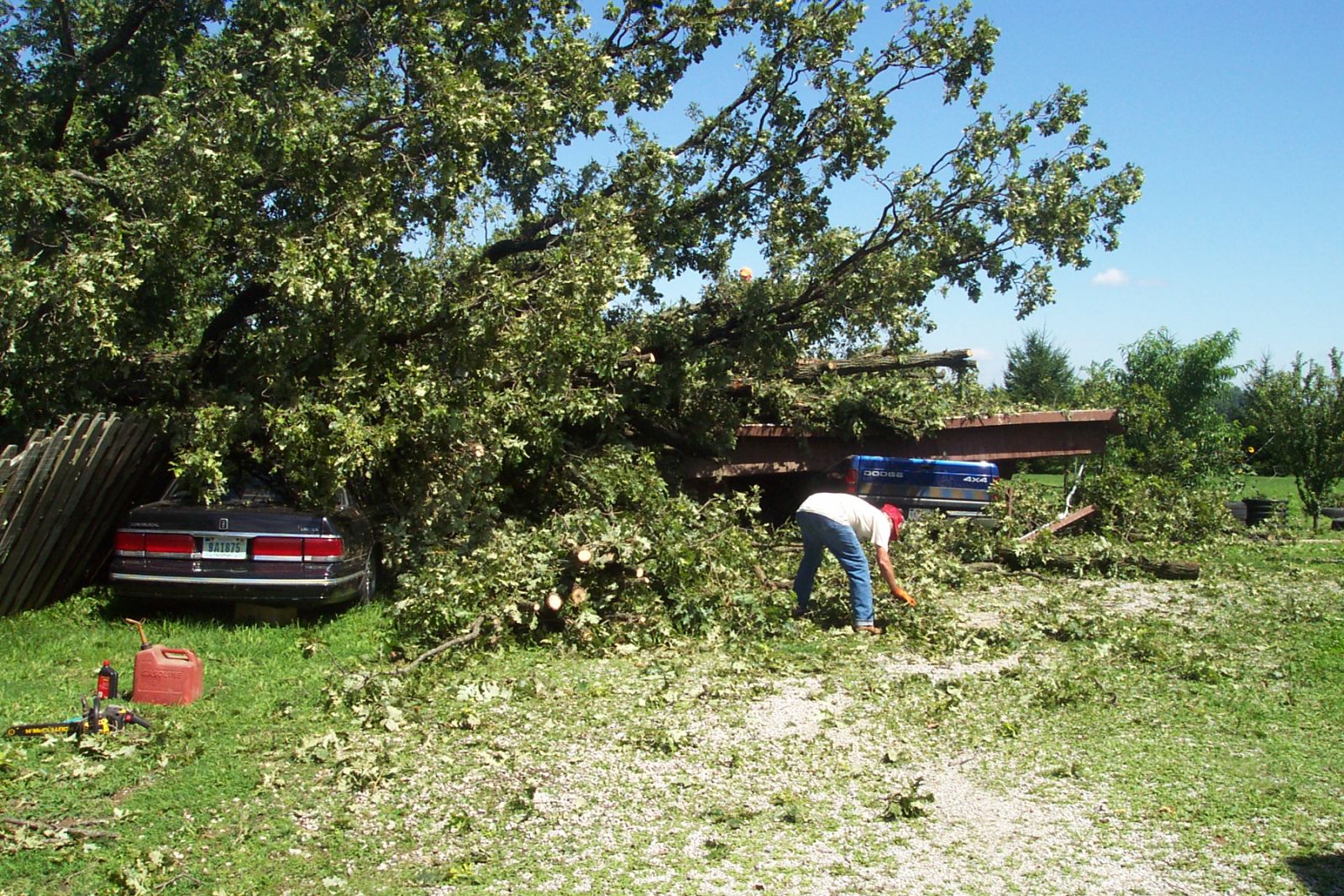
850 E AND 550 S. THIS DAMAGE WAS THE RESULT OF STRAIGHT LINE
MICROBURST WINDS. MAXIMUM WIDTH 50 YARDS. A LARGE TREE FELL ONTO A
CARPORT WHERE 3 CARS WERE LOCATED.
GROUND OBSERVATIONS CONFIRMED A TORNADO TOUCHED DOWN A FEW HUNDRED
FEET W OF COUNTY ROAD 950 E BETWEEN 500 AND 600 S...JUST SOUTH OF
ONWARD IN CASS COUNTY. BASED ON RADAR DATA TOUCHDOWN WAS AROUND 825
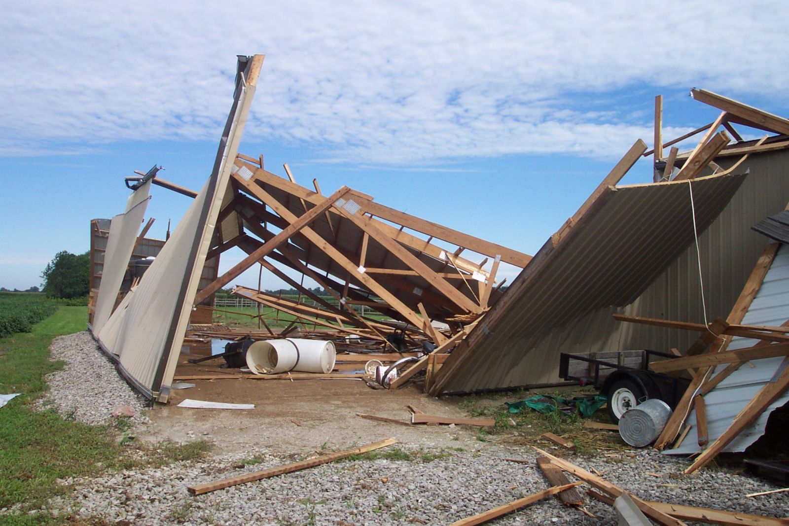
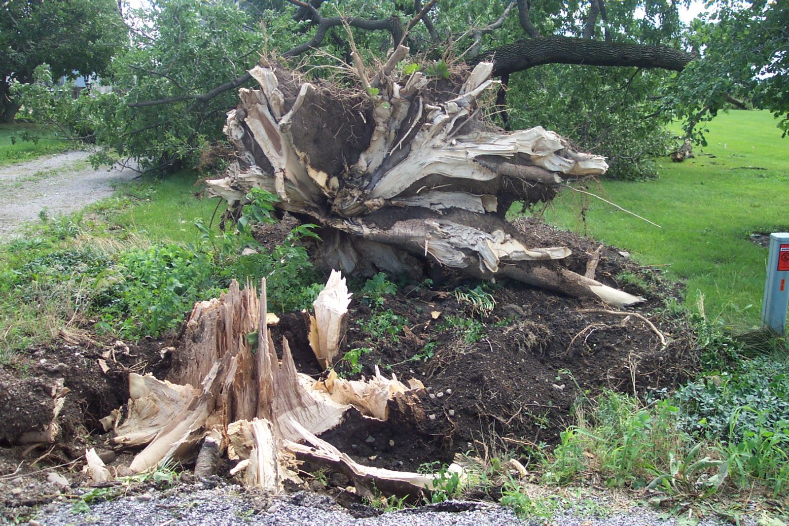
PM EST. EXTENSIVE DAMAGE OCCURRED TO A BARN AS WELL AS NUMEROUS
TREES IN THE AREA. THE DOOR OF THE BARN WAS OPEN WHICH LIKELY AIDED
IN THE DESTRUCTION OF THE BARN. MAXIMUM DAMAGE IN THIS AREA WAS
RATED AT F2.
...MIAMI COUNTY...
THE TORNADO CROSSED INTO MIAMI COUNTY ABOUT 4 MILES NORTHWEST OF
BUNKER HILL NEAR THE MILL CREEK QUARRY. A FEW GRAVEL CONVEYORS IN
THE AREA WERE FLIPPED...CONSISTENT WITH F1 DAMAGE. THE TORNADO
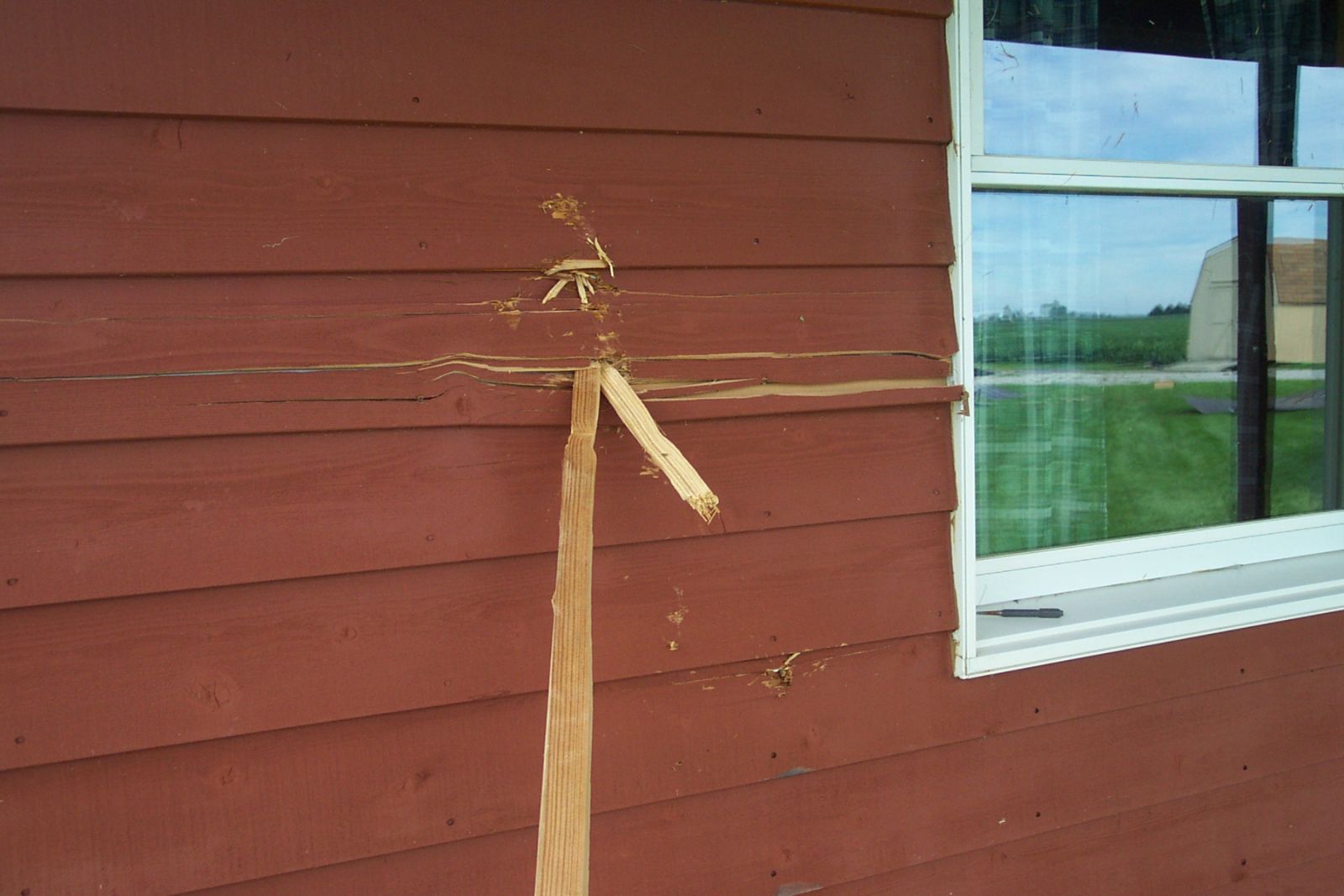
CROSSED PIPE CREEK AND STRUCK SEVERAL HOUSES. ONE HOME HAD EXTENSIVE
DAMAGE WITH THE GARAGE AND PORCH AREAS COMPLETELY DESTROYED. DAMAGE
FROM THIS HOME IMPACTED A SECOND HOME CAUSING EXTENSIVE STRUCTURAL
DAMAGE TO THE WEST HALF OF THE BUILDING. 4 OTHER STRUCTURES IN THIS
AREA SUSTAINED DAMAGE. MAXIMUM DAMAGE TO THESE STRUCTURES WAS RATED
AT F2. THE TORNADO QUICKLY DISSIPATED AS IT MOVED OUT OF THE CREEK
VALLEY NEAR U.S. ROUTE 31 ABOUT 2 MILES NORTH OF THE MAIN ENTRANCE
AT GRISSOM AIR RESERVE BASE.
DAMAGE WAS ALSO REPORTED AT EAGLES POINT WITH TREES DOWN...AS WELL
AS 2 HOUSES SUSTAINING LIGHT TO MODERATE DAMAGE. HOUSES ALONG US 31
IN MCGRAWVILLE AND AMBOY WERE ALSO DAMAGED WITH STATE ROAD 19 CLOSED
IN AMBOY. CEDAR CREEK TRAILER PARK...NEAR BUNKER HILL...HAD MANY
TREES DOWN BUT NO SIGNS OF HOME DAMAGE. SEVERAL TREES WERE DOWN ONTO
A FEW MOBILE HOMES IN THE PIPE CREEK MOBILE HOME PARK. ALL OF THIS
DAMAGE WAS THE RESULT OF STRAIGHT LINE WINDS FROM THE SEVERE
THUNDERSTORM. STRAIGHT LINE WINDS CAN BE JUST AS STRONG AS WINDS
ASSOCIATED WITH A TORNADO AND CAN CAUSE AS MUCH DAMAGE.
$$
HITCHCOCK/EDDY/WAMSLEY/FISHER
The following are pictures taken from the Storm Survey conduced by the National Weather Service in Northern Indiana. Hover your mouse over the image for a description. Click on the thumbnails for a larger image.

7/31/05...LWF/JPH/SLL


