A National Weather Service assessment team has preliminarily concluded a damage survey of the affected areas. All damage that was observed was consistent with straight line wind damage. There was no evidence of a tornado.
A supercell thunderstorm developed Wednesday afternoon along a lake breeze boundary just south of Milwaukee, Wisconsin. The storm moved southeast and then south over the lake continuing to intensify. As the storm moved onshore in Michigan City, Indiana, a 106 mph wind gust was recorded at the GLERL observation site near the Michigan City lighthouse. The storm produced extensive damage in in Michigan City with numerous trees and power lines down, some on cars and buildings. A train was blown off the tracks in northern Porter County . Golf ball sized hail, which covered the ground in places, was also reported with this storm. Washington Park was especially hard hit as thunderstorm winds swept in off the lake. The largest in water boat show in the Great Lakes was setting up in the park for a 4 day show. Several boats and trailers were destroyed, and the tents and merchandise were significantly damaged and scattered all over.
The storm continued to produce damage as it moved south through Laporte County with extensive damage in Westville and the City of LaPorte. As the storm continued south into Starke County , tennis ball sized hail was reported along U.S. Route 30, a few miles west of Hamlet. The storm continued to produce large hail and strong winds as it dropped south through Pulaski and White counties with damage reported in Winamac, Medaryville, and Monticello .
Click for a list of wind damage and hail reports.
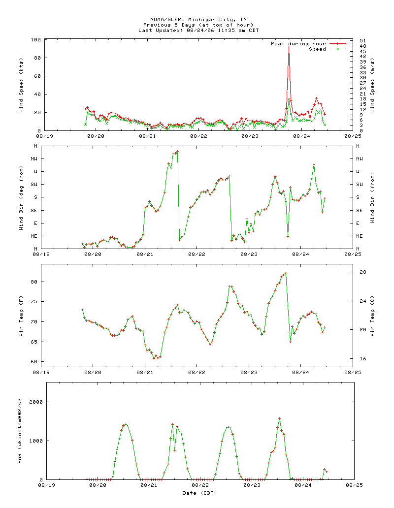
The following is a chart from the Michigan City GLERL observation site. Note the wind gust on the top chart of 92 knots (106 mph). Also of note, the third chart down shows the temperature dropping from the low 80s to the low 60s in one hour as rain cooled air rushed out of the thunderstorm.
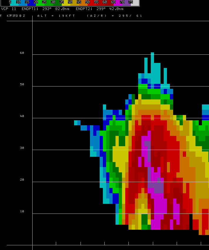
The following image is a cross section of the supercell thunderstorm just before it moved onshore in Michigan City. Note the 60-65 dBz returns elevated at up to 35 thousand feet. This represents the hail and heavy rain being held up at high altitudes by the intense storm updraft. Also note the notch of weaker reflectivity (greens and oranges) in the lower parts of the storm below 20 thousand feet. This is what is known as a Bounded Weak Echo Region, or BWER, a classic radar signature of a supercell. The BWER is co-located with the intense thunderstorm updraft. The updraft is so intense that is does not allow much hail or rain to fall down through it, resulting in the notch of weaker radar returns.