Northern Indiana
Weather Forecast Office
Isolated severe thunderstorms developed Thursday night over sections of the forecast area. The thunderstorms produced strong winds up to 70 mph, large hail, and heavy rainfall. The strongest storm developed over Branch county Michigan Thursday evening. Ample instability along with moderate wind shear (change in wind speed and direction with height) allowed the updraft of this thunderstorm to become intense. Strong rotation developed in this storm in response to the wind shear present, allowing the development of what is known as a supercell thunderstorm. This supercell thunderstorm dropped hail up to the size of golf balls along with wind gusts to 70 mph as it moved southeast into northeast Indiana and northwest Ohio. A funnel cloud was also observed with this storm just west of Edon Ohio at 843 pm EDT. Below are a few radar images taken from when the thunderstorm updraft was very intense. At this time the storm was producing golf ball size hail over Williams and Defiance counties.
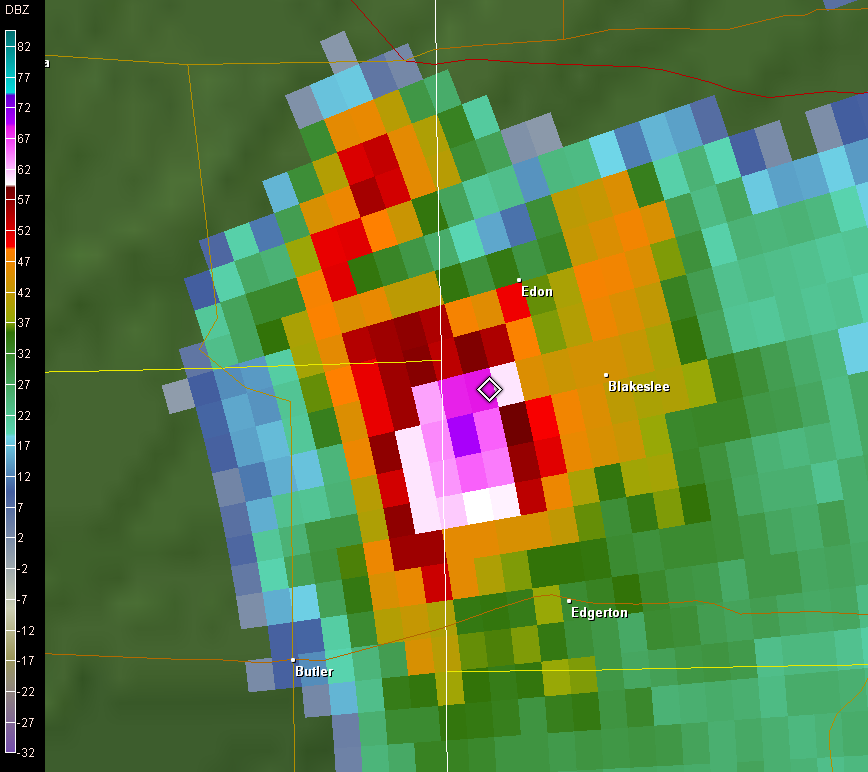
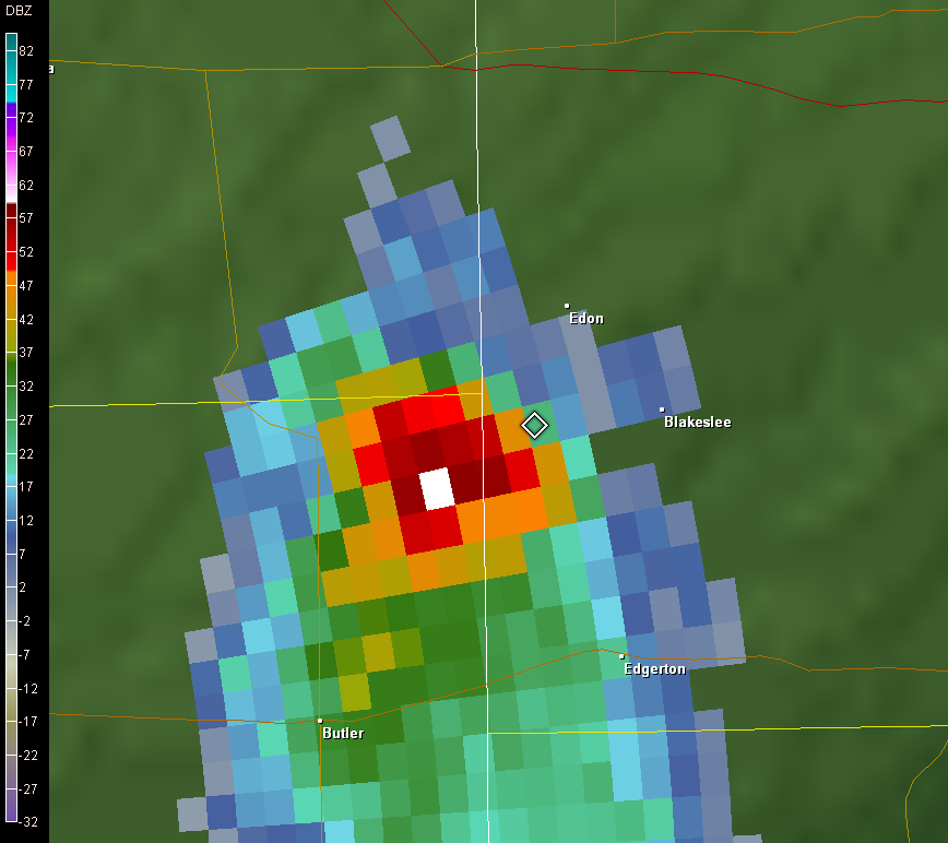
The following sequence of pictures shows the collapse of the hail core in western Defiance county. Also, evident on the left hand side of the first image is the echo free vault of the thunderstorm. An echo free vault is an attribute of a very intense thunderstorm as it indicates that the updraft is strong enough to suspend precipitation particles (such as hail) aloft for a long period of time.
.png)
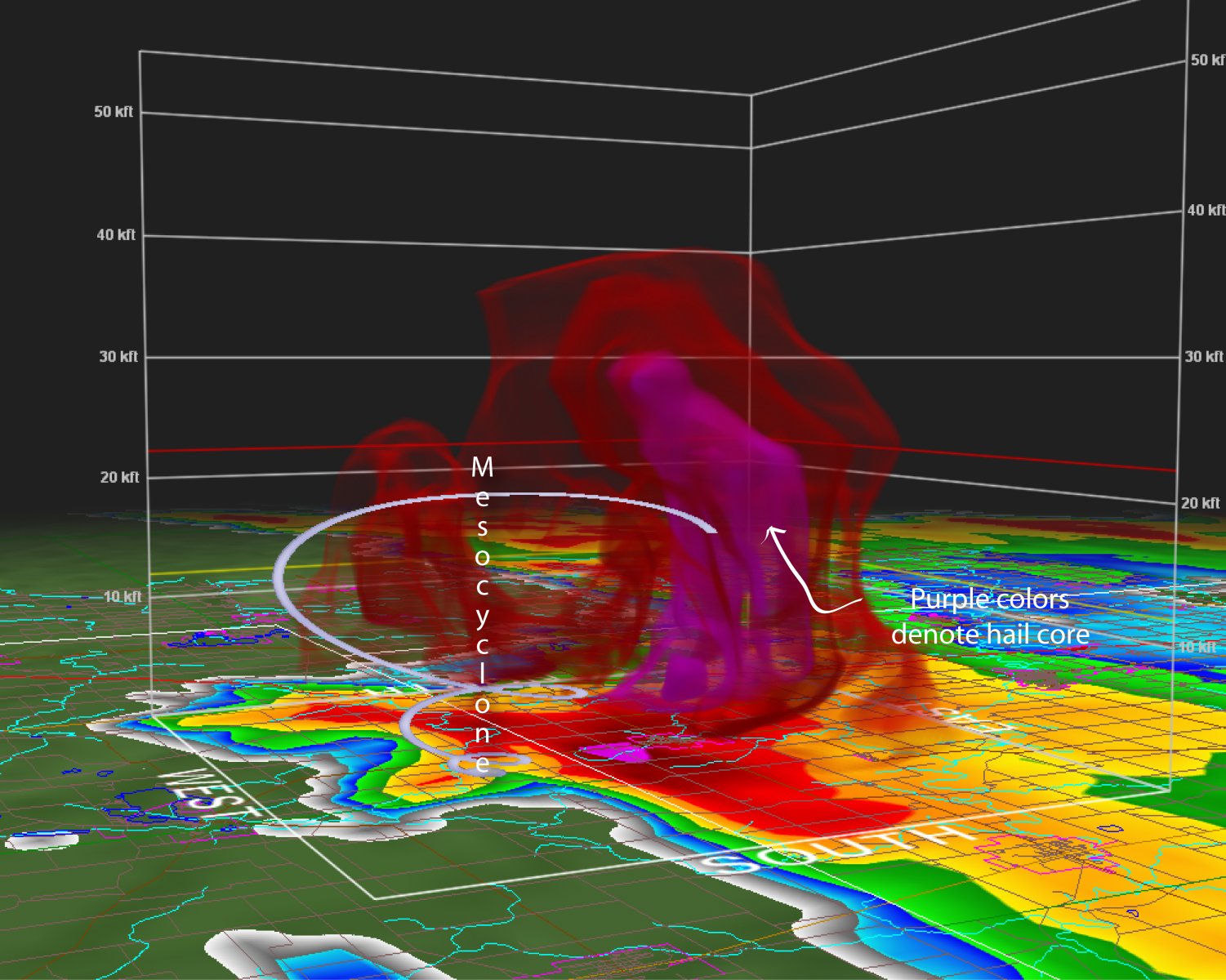
A 3D rendering of this storm, at 840 pm EDT over Edon Ohio, below clearly shows the deep ice core within this intense supercell. Spiral indicates the intense mesocyclone occurring within the updraft and caught on video by storm chaser Steve Ferree. Note the brief funnel that develops below the base of this intense mesocyclone.
NWUS53 KIWX 270431
LSRIWX

PRELIMINARY LOCAL STORM REPORT...SUMMARY
NATIONAL WEATHER SERVICE NORTHERN INDIANA
1231 AM EDT FRI JUL 27 2007

..TIME..    ...EVENT...     ...CITY LOCATION...      ...LAT.LON...
..DATE..    ....MAG....     ..COUNTY LOCATION.. ST.. ...SOURCE....
            ..REMARKS..

0705 PM     HAIL             4 E BRONSON             41.87N  85.11W
07/26/2007  E0.50 INCH       BRANCH             MI   TRAINED SPOTTER

            HALF INCH HAIL


0713 PM     HAIL             UPLAND                  40.46N  85.51W
07/26/2007  E0.75 INCH       GRANT              IN   TRAINED SPOTTER

            PENNY SIZE HAIL IN UPLAND


0716 PM     TSTM WND DMG     4 SE UPLAND             40.42N  85.46W
07/26/2007                   GRANT              IN   EMERGENCY MNGR

            TREES AND POWERLINES DOWN


0722 PM     TSTM WND DMG     1 S HARTFORD CITY       40.44N  85.37W
07/26/2007                   BLACKFORD          IN   LAW ENFORCEMENT

            SEVERAL TREES AND POWERLINES DOWN SOUTH OF HARTFORD
            CITY


0745 PM     TSTM WND DMG     2 WNW FREMONT           41.74N  84.97W
07/26/2007                   STEUBEN            IN   EMERGENCY MNGR

            WIDESPREAD TREES AND POWERLINES DOWN ACROSS
            COUNTY...WORSE DAMAGE NEAR TOLL ROAD WEST OF FREMONT


0750 PM     HAIL             FREMONT                 41.73N  84.93W
07/26/2007  E1.00 INCH       STEUBEN            IN   AMATEUR RADIO

            THREE QUARTER TO ONE INCH HAIL IN FREMONT


0756 PM     TSTM WND GST     3 W FREMONT             41.73N  84.99W
07/26/2007  E70 MPH          STEUBEN            IN   EMERGENCY MNGR

            EMA DAMAGE SURVEY...STRAIGHT LINE WIND DAMAGE...NORTH
            STRIP MALL SIGNIFICANTLY DAMAGED...SOFFIT BLOWN
            OUT...ROOF DAMAGE...WINDOW BROKEN...MANY TREES DOWN WITH
            ONE ON CAR. 20 INCH DIAMETER TREE UPROOTED. TREES AND A
            LIGHTPOLE DOWN AT THE HOLLIDAY INN EXPRESS ALONG WITH
            SEVERAL OTHER REPORTS OF TREES DOWN IN THE AREA.


0805 PM     HAIL             4 NNE ANGOLA            41.70N  84.97W
07/26/2007  E1.75 INCH       STEUBEN            IN   TRAINED SPOTTER

            GOLF BALL SIZE HAIL FALLING


0808 PM     HAIL             FREMONT                 41.73N  84.93W
07/26/2007  E0.75 INCH       STEUBEN            IN   TRAINED SPOTTER

            PENNY SIZE HAIL


0900 PM     HAIL             EDGERTON                41.45N  84.75W
07/26/2007  E0.88 INCH       WILLIAMS           OH   LAW ENFORCEMENT

            NICKEL SIZE HAIL


0903 PM     HAIL             EDGERTON                41.45N  84.75W
07/26/2007  E1.00 INCH       WILLIAMS           OH   LAW ENFORCEMENT

            QUARTER SIZE HAIL


0912 PM     HAIL             1 NE EDGERTON           41.46N  84.74W
07/26/2007  E0.75 INCH       WILLIAMS           OH   TRAINED SPOTTER

            PENNY SIZE HAIL


0916 PM     HAIL             1 NE EDGERTON           41.46N  84.74W
07/26/2007  E1.75 INCH       WILLIAMS           OH   TRAINED SPOTTER

            GOLF BALL SIZE HAIL WINDS ESTIMATED AT 50 MPH


0923 PM     HAIL             3 E EDGERTON            41.45N  84.69W
07/26/2007  E1.75 INCH       WILLIAMS           OH   LAW ENFORCEMENT

            GOLF BALL SIZE HAIL ON US 6 EAST OF EDGERTON


0933 PM     HAIL             1 W FARMER              41.38N  84.65W
07/26/2007  E1.75 INCH       DEFIANCE           OH   LAW ENFORCEMENT

            GOLF BALL SIZE HAIL


1023 PM     TSTM WND DMG     2.5 SE FAYETTE          41.65N  84.29W
07/26/2007                   FULTON             OH   LAW ENFORCEMENT

            TOP OF BARN TAKEN OFF AND TREES DOWN


&&

$$

BJS
Hazards
Heat Related
Winter Related
Watch/Warning
Outlook
Storm Reports
Storm Prediction Center
Submit a Report
Event Ready
Climate
FWA Daily
SBN Daily
FWA Monthly
SBN Monthly
CoCoRaHS
Spring Frost Climatology
Fall Frost Climatology
Severe Climatology
Local Information
Skywarn
COOP
Our Office
WSR-88D
Headline Criteria
NOAA Weather Radio
Weather History
Probabilistic Snowfall
Public Information Statement
Social Media Feeds
Weather Events Page
US Dept of Commerce
National Oceanic and Atmospheric Administration
National Weather Service
Northern Indiana
7506 E 850 N
Syracuse, IN 46567
574-834-1104
Comments? Questions? Please Contact Us.

