Northern Indiana
Weather Forecast Office
Heavy snow fell across far Northern Indiana and southwestern lower Michigan starting New Years Eve night and continuing through early Tuesday. Rapidly intensifying low pressure tracked out of the southern plains into parts of Indiana and Ohio. The heaviest snowfall from the system occurred along and borthwest of a Logansport to Columbia City to Montpelier OH line with some locations reporting upwards of 15 to 20 inches before the system moved away.
While the widespread snow departed with the area of low pressure, bands of lake effect snow setup across much of the area with several more focused and intense bands evolving and moving across northern parts of the area. This allowed for isolated increases in snowfall totals downwind of the lake with some locations seeing 3 day storm totals over over 2 feet of snow.
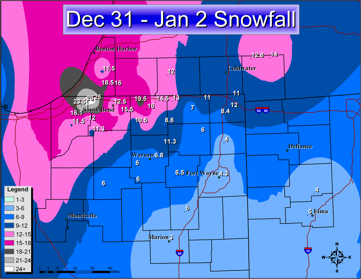
PRELIMINARY SNOWFALL TOTALS FROM NEW YEARS EVE THROUGH 10AM ON
THURSDAY JANUARY 3 2008 ARE PROVIDED BELOW...
LOCATION SNOWFALL COMMENTS
IN/S/
HUDSON LAKE IN 26.0 01/02/08 0714 PM
NEW CARLISLE IN 25.0 01/02/08 0445 PM
ROLLING PRARIE IN 23.5 01/02/08 0804 PM
BRONSON MI 20.5 01/02/08 0718 PM
ELKHART IN 19.5 01/01/08 0700 PM
BUCHANAN MI 18.5 01/02/08 1114 PM
LA PORTE IN 16.1 01/02/08 1024 PM
NILES MI 16.0 01/02/08 0554 PM
DUNLAP IN 16.0 01/01/08 0637 PM
2 SE MISHAWAKA IN 15.5 01/03/08 0735 AM
MISHAWAKA IN 15.0 01/02/08 0715 AM
2 N GRANGER IN 15.0 01/03/08 0700 AM
BRISTOL IN 14.5 01/01/08 1000 PM
MOSCOW MI 14.0 01/02/08 0100 PM
GOSHEN IN 13.0 01/01/08 0750 AM
LITCHFIELD MI 12.8 01/03/08 0635 AM
SOUTH BEND IN 12.5 01/01/08 0757 PM
1 E SOUTH BEND IN 12.5 01/01/08 0700 PM
THREE RIVERS MI 12.0 01/01/08 1130 AM
MOTTVILLE MI 12.0 01/01/08 0710 AM
GRANGER IN 12.0 01/01/08 0700 PM
FISH LAKE IN 12.0 01/01/08 1030 PM
CONSTANTINE MI 12.0 01/01/08 0734 AM
ANGOLA IN 12.0 01/02/08 0106 AM
KINGSBURY IN 11.5 01/02/08 1227 PM
BERRIEN SPRINGS MI 11.5 01/02/08 0813 AM
WALKERTON IN 11.3 01/02/08 1228 PM
2 N NORTH WEBSTER IN 11.3 01/01/08 0711 PM
FREMONT IN 11.0 01/02/08 1228 PM
4 N ANGOLA IN 11.0 01/02/08 0647 AM
WAKARUSA IN 10.5 01/01/08 0700 AM
SIMONTON LAKE IN 10.5 01/01/08 0600 PM
7 NNW SHIPSHEWANA IN 10.0 01/01/08 0700 AM
1 N GRANGER IN 10.0 01/01/08 0300 PM
ROCHESTER IN 9.2 01/02/08 0946 AM
MILLERSBURG IN 8.8 01/01/08 0600 PM
NORTH JUDSON IN 8.5 01/02/08 1233 PM
CASSOPOLIS MI 8.5 01/01/08 1153 AM
6 SW ANGOLA IN 8.4 01/02/08 1015 AM
PLYMOUTH IN 8.0 01/01/08 0800 AM
MICHIGAN CITY IN 8.0 01/01/08 1130 AM
3 SSE WALKERTON IN 8.0 01/01/08 0700 AM
1 E ELKHART IN 8.0 01/01/08 0147 AM
KNOX IN 7.6 01/02/08 1233 PM
OSWEGO IN 7.5 01/01/08 0258 PM
COLDWATER MI 7.0 01/01/08 0347 AM
ASHLEY IN 7.0 01/02/08 0246 AM
LAGRANGE IN 6.8 01/01/08 0329 AM
4 SW KNOX IN 6.8 01/01/08 0700 AM
2 E WARSAW IN 6.8 01/02/08 0327 PM
SOUTH WHITLEY IN 6.5 01/01/08 0629 PM
MENTONE IN 6.0 01/01/08 0321 PM
KEWANNA IN 6.0 01/01/08 0600 PM
KENDALLVILLE IN 6.0 01/02/08 1231 PM
HUNTINGTON IN 6.0 01/02/08 0633 AM
AKRON IN 6.0 01/01/08 0810 PM
2 W LIMA OH 5.0 01/02/08 0717 AM
LIMA OH 4.7 01/02/08 0547 AM
HEADLEE IN 4.5 01/03/08 0842 AM
COLUMBIA CITY IN 4.4 01/02/08 1230 PM
FORT WAYNE IN 4.3 01/03/08 0647 AM
COLUMBUS GROVE OH 4.0 01/02/08 0832 AM
AUBURN IN 4.0 01/02/08 1230 PM
MARION IN 3.0 01/01/08 0807 PM
VAN WERT OH 2.1 01/02/08 1248 PM
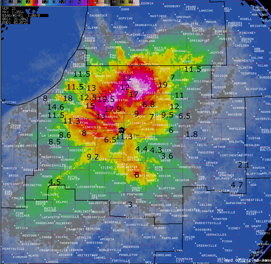
The colors in this image show radar estimated event total water equivalent for rain and snow. Selected snowfall reports from weather spotters, CoCoRAHS observers, WSBT, and amateur radio reports (black text) are shown in inches.
Thanks to all the weather observers, media outlets, CoCoRAHS and Amateur Radio Networks for the excellent reports.
Hazards
Heat Related
Winter Related
Watch/Warning
Outlook
Storm Reports
Storm Prediction Center
Submit a Report
Event Ready
Climate
FWA Daily
SBN Daily
FWA Monthly
SBN Monthly
CoCoRaHS
Spring Frost Climatology
Fall Frost Climatology
Severe Climatology
Local Information
Skywarn
COOP
Our Office
WSR-88D
Headline Criteria
NOAA Weather Radio
Weather History
Probabilistic Snowfall
Public Information Statement
Social Media Feeds
Weather Events Page
US Dept of Commerce
National Oceanic and Atmospheric Administration
National Weather Service
Northern Indiana
7506 E 850 N
Syracuse, IN 46567
574-834-1104
Comments? Questions? Please Contact Us.

