Northern Indiana
Weather Forecast Office
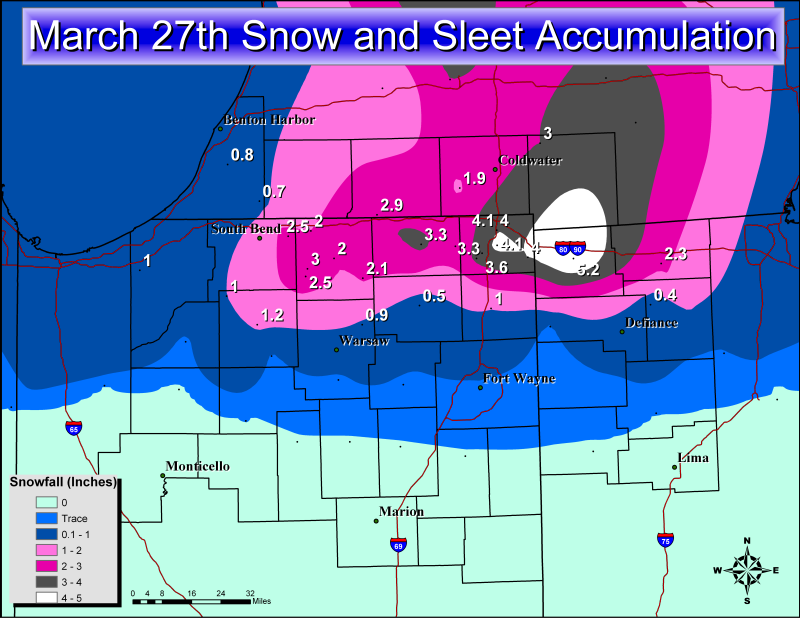
A late season winter storm moved quickly through the area Thursday night, dropping several inches of snow and rain over the area. Precipitation began in earnest late Thursday afternoon in the form of rain and thunderstorms in northern Indiana, southern Lower Michigan, and northwest Ohio. The precipitation transitioned back and forth from rain to sleet to snow several times before setting up as mostly snow along and north of US Highway 6; a rain/sleet/snow mix between US 6 and US 30; and mainly rain south of US 30. Locations where snow became the dominate form of precipitation received anywhere from 2 to over 5 inches with the heaviest snow falling near the Tri-State area of Indiana, Ohio, and Michigan. Snowfall reports were almost certainly underestimated as the very wet and heavy snow compacted through the night before observations were taken this morning. Before the event on Thursday, the National Weather Service in Northern Indiana issued a Winter Weather Advisory mentioning 2 to 6 inches of snow and periods of heavy sleet that could cause travel problems.
Locations that saw only rain saw lots of it, with most places reporting over 0.75 inches. Some areas near Fort Wayne reported over 1.50 inches of rain from 7AM Thursday through 7AM Friday. This precipitation has led to rises in many rivers, and minor flooding along the Tiffin River near Stryker in northwest Ohio. Below is a map of snowfall totals and a satellite image of Friday morning’s snowpack:
Simpson
Hazards
Heat Related
Winter Related
Watch/Warning
Outlook
Storm Reports
Storm Prediction Center
Submit a Report
Event Ready
Climate
FWA Daily
SBN Daily
FWA Monthly
SBN Monthly
CoCoRaHS
Spring Frost Climatology
Fall Frost Climatology
Severe Climatology
Local Information
Skywarn
COOP
Our Office
WSR-88D
Headline Criteria
NOAA Weather Radio
Weather History
Probabilistic Snowfall
Public Information Statement
Social Media Feeds
Weather Events Page
US Dept of Commerce
National Oceanic and Atmospheric Administration
National Weather Service
Northern Indiana
7506 E 850 N
Syracuse, IN 46567
574-834-1104
Comments? Questions? Please Contact Us.

