Northern Indiana
Weather Forecast Office
Two tornadoes were confirmed by National Weather Service meteorologists after damage surveys. The first tornado, an EF1, hit the Countryside Mobile Home Park in Columbia City in Whitley County, Indiana and the second tornado, an EF0, occurred in south central Defiance County, Ohio. No fatalities or major injuries occurred in either of the tornadoes thanks in part to great spotter reports and NWS ;Tornado Warning lead times for the Whitley and Defiance County tornadoes of 17 and 13 minutes respectively.
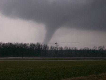
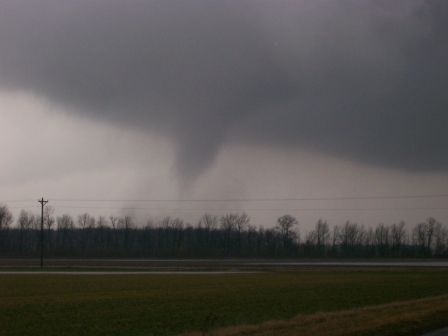
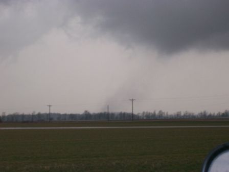
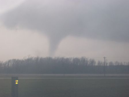
Several pictures of the Defiance County tornado taken by storm chasers Eric Martinez and Derek Tanner from near Cecil-Williams Center Road and Jericho Road can be seen below:
Write ups of the two tornadoes can be found by clicking on title of the damage maps. The damage points can be clicked on for descriptions and pictures.
Defiance County EF0 Tornado (click for text description)
   ...TORNADO CONFIRMED IN DEFIANCE COUNTY OHIO...

THE NATIONAL WEATHER SERVICE HAS CONDUCTED A DAMAGE SURVEY IN
DEFIANCE COUNTY OHIO AND DETERMINED A HIGH END EF0 TORNADO DID
OCCUR. A HIGH END EF0 TORNADO HAS WIND SPEEDS OF 80 TO 85 MPH ON THE
ENHANCED FUJITA SCALE AND IS BASED ON THE DAMAGED OBSERVED.

DAMAGE ASSOCIATED WITH THIS TORNADO BEGAN JUST EAST OF MARK CENTER
ON WILLIAMS CENTER-CECIL ROAD WHERE APPROXIMATELY 8 UTILITY POLES
WERE BLOWN DOWN TO THE EAST...WITH ONE POLE SNAPPED IN THE MIDDLE.
IMMEDIATELY TO THE NORTHEAST OF THESE POLES ON THE SOUTH SIDE OF
HIGHWAY 18 WAS A SMALL BARN BLOWN OFF ITS FOUNDATION BUT THE
BUILDING WAS LEFT INTACT WITH SURROUNDING TREES AND BUILDINGS NOT
DAMAGED. DAMAGE WAS ALSO OBSERVED AT A FARM HOUSE ON THE NORTH SIDE
OF HIGHWAY 18. A PORTION OF THE ROOF FROM THIS HOUSE WAS BLOWN TO
THE NORTHEAST WITH SEVERAL SMALL LIMBS BROKE OFF BUT LARGE TREES AND
OTHER BUILDINGS ON THE PROPERTY WERE AGAIN LEFT INTACT AND NOT
DAMAGED.

THE TORNADO APPEARED TO LIFT BUT TOUCHED DOWN AGAIN TO THE NORTHEAST
ON OPENLANDER ROAD BETWEEN LOCKWOOD AND STATE ROAD 18. THE FRONT
PORCH OF A HOME WAS RIPPED FROM THE HOUSE AND DEPOSITED NORTHEAST. A
TELEVISION ANTENNA AND LARGE TREE WERE ALSO TAKEN DOWN. A LARGE BARN
HAD A PORTION OF ITS ROOF PEELED OFF AS WELL BUT THE MAIN STRUCTURES
REMAINED STANDING WITH MINOR DAMAGE.

THE TORNADO APPEARED TO LIFT ONCE MORE AND MOVED OVER A LARGE AREA
OF TREES WITH NO APPARENT DAMAGE. A BRIEF TOUCH DOWN OCCURRED AGAIN
AT A VACATED HOUSE ON BUCKSKIN ROAD JUST EAST OF HIGHWAY 127. A
SMALL CONVERGENT CIRCULATION PATTERN WAS OBSERVED IN THE CUT STALKS
OF CORN LEFT IN THE FIELD. THIS WAS IN LINE WITH MINOR SIDING DAMAGE
AND BROKEN WINDOWS ON THE HOME AND NUMEROUS BROKEN LIMBS.

A FINAL TOUCHDOWN OCCURRED ON MUD CREEK ROAD WHERE AN ATTACHED
GARAGE ON A SINGLE STORY HOME WAS LIFTED SLIGHTLY AND SHIFTED
APPROXIMATELY ONE FOOT TO THE EAST. THE REMAINDER OF THE HOUSE ONLY
HAD MINOR SIDING DAMAGE AND SOME SHINGLES MISSING. SEVERAL TREES
SURROUNDING THE HOME ONLY HAD SMALL LIMBS BROKEN OFF AND A FEW
EVERGREEN TYPE TREES WERE UPROOTED OR SNAPPED OFF. A BARN DOOR ALSO
WAS BLOWN INWARD ON A BUILDING NEXT TO THE HOUSE.

SEVERAL WITNESSES REPORTED SEEING A TORNADO THAT APPEARED TO BE
SKIPPING AND THIS IS CONSISTENT WITH THE DAMAGE OBSERVED AND THE
PATH. THE PATH LENGTH BASED ON THE SCATTERED DAMAGE HAS BEEN
DETERMINED TO BE 5.1 MILES WITH A MAXIMUM WIDTH OF ONLY 50 YARDS. A
TORNADO WARNING HAD BEEN ISSUED AT 551 PM EDT FOR DEFIANCE COUNTY
AND THE FIRST REPORT OF A TORNADO CAME AT 604 PM EDT.

IF YOU HAVE DAMAGE TO REPORT FROM THIS STORM...PLEASE NOTIFY YOUR
LOCAL LAW ENFORCEMENT AGENCY FOR RELAY TO THE NATIONAL WEATHER
SERVICE OR VISIT WWW.WEATHER.GOV/IWX AND SUBMIT A REPORT TO THE
WEBMASTER. THE NATIONAL WEATHER SERVICE IS ALSO INTERESTED IN ANY
PICTURES OR VIDEO FROM THIS EVENT.
Whitley County EF1 Tornado (click for text description)
...TORNADO CONFIRMED IN WHITLEY COUNTY...

THE NATIONAL WEATHER SERVICE CONDUCTED A DAMAGE SURVEY IN
COLUMBIA CITY. AN EF1 TORNADO WITH WINDS OF 105 MPH WAS
CONFIRMED IN THE COUNTRYSIDE TRAILER PARK NEAR THE INTERSECTION OF
STATE ROAD 9 AND HIGHWAY 30 IN COLUMBIA CITY. DAMAGE THAT OCCURRED
NEAR NORTH MANCHESTER IN NORTHEAST WABASH COUNTY WAS DETERMINED TO
BE FROM STRAIGHT LINE WINDS AND NOT A TORNADO.

IT HAS BEEN DETERMINED THAT AN EF1 TORNADO...WITH WINDS OF
105 MPH BASED ON THE ENHANCED FUJITA SCALE...TOUCHED DOWN AT THE
COUNTRYSIDE TRAILER PARK LOCATED NEAR THE INTERSECTION OF STATE ROAD
9 AND HIGHWAY 30 IN COLUMBIA CITY. THREE TRAILERS WERE COMPLETELY
DESTROYED AND NEARLY 20 OTHER TRAILERS SUSTAINED DAMAGE RANGING FROM
MINOR TO MAJOR. PATH LENGTH WAS DETERMINED TO BE ABOUT ONE THIRD
OF A MILE WITH A MAXIMUM WIDTH OF 100 YARDS.

THE STORM THAT SPAWNED THIS TORNADO ALSO DID DAMAGE NEAR NORTH
MANCHESTER IN NORTHEAST WABASH COUNTY. TWO BARNS SUFFERED ROOF
DAMAGE ALONG WITH TREE DAMAGE. ONE SERIOUS INJURY OCCURRED HERE.
THIS DAMAGE WAS CONSISTENT WITH STRAIGHT LINE WINDS ESTIMATED TO BE
AROUND 70 MPH.
Lashley/Logsdon/Simpson/Holsten/Fisher
Hazards
Heat Related
Winter Related
Watch/Warning
Outlook
Storm Reports
Storm Prediction Center
Submit a Report
Event Ready
Climate
FWA Daily
SBN Daily
FWA Monthly
SBN Monthly
CoCoRaHS
Spring Frost Climatology
Fall Frost Climatology
Severe Climatology
Local Information
Skywarn
COOP
Our Office
WSR-88D
Headline Criteria
NOAA Weather Radio
Weather History
Probabilistic Snowfall
Public Information Statement
Social Media Feeds
Weather Events Page
US Dept of Commerce
National Oceanic and Atmospheric Administration
National Weather Service
Northern Indiana
7506 E 850 N
Syracuse, IN 46567
574-834-1104
Comments? Questions? Please Contact Us.

