Northern Indiana
Weather Forecast Office
Low pressure, tracking from Arkansas the evening of the 24th, to southwestern Pennsylvania the morning of the 25th, brought a large area of snow to the forecast area. The snow was slow to start as dry air remained in place across much of the area, keeping much of the forecasted amounts from being realized. However, once the snow did develop, several bands of moderate to locally heavy snow formed with snowfall rates of an inch or more per hour. The snow quickly ended by mid morning of the 25th. Images before show the Surface Low Maps, select radar images and observations and the 24 hour total for snowfall (Thanks to all that sent in reports).
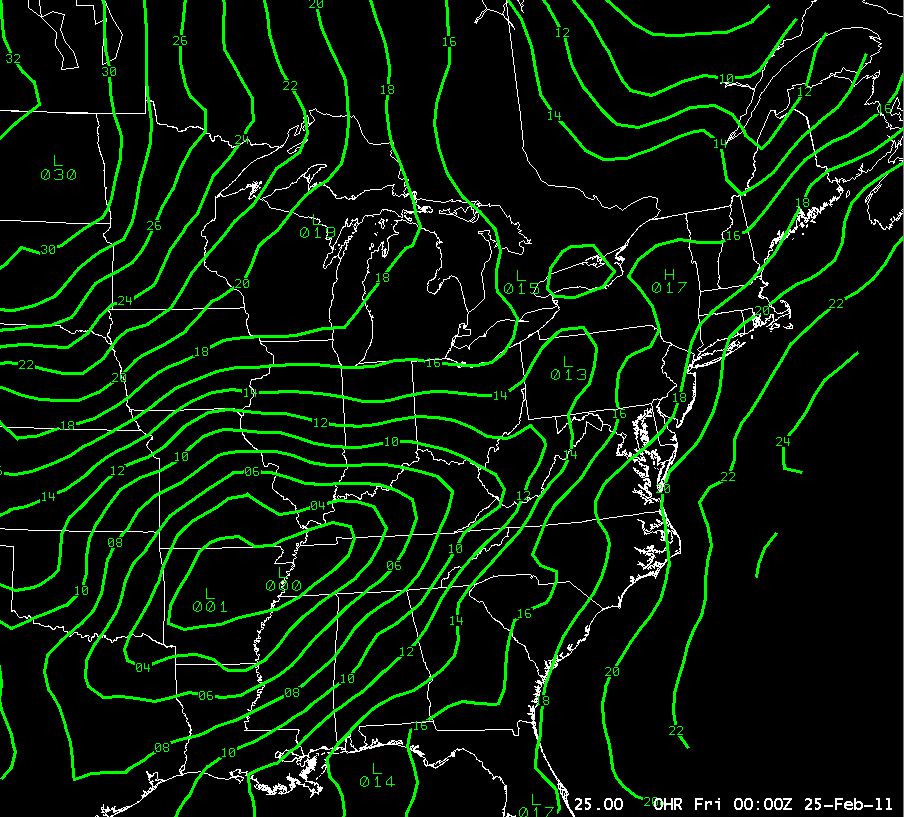 |
7 pm Surface Map February 24th |
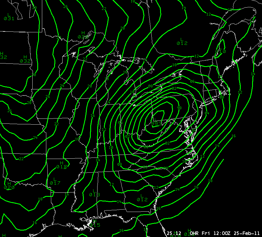 |
7 am Surface Map February 25th |
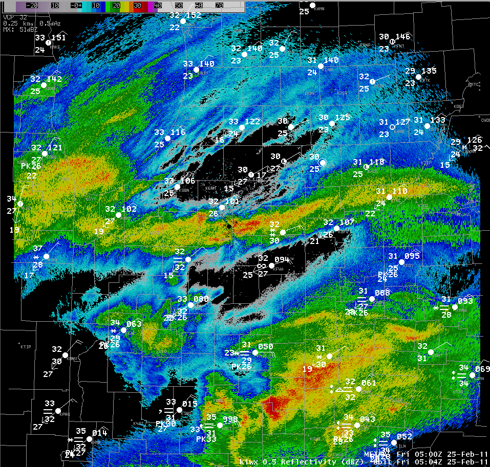 |
Radar and Observations at 12 am EST Feb 25th |
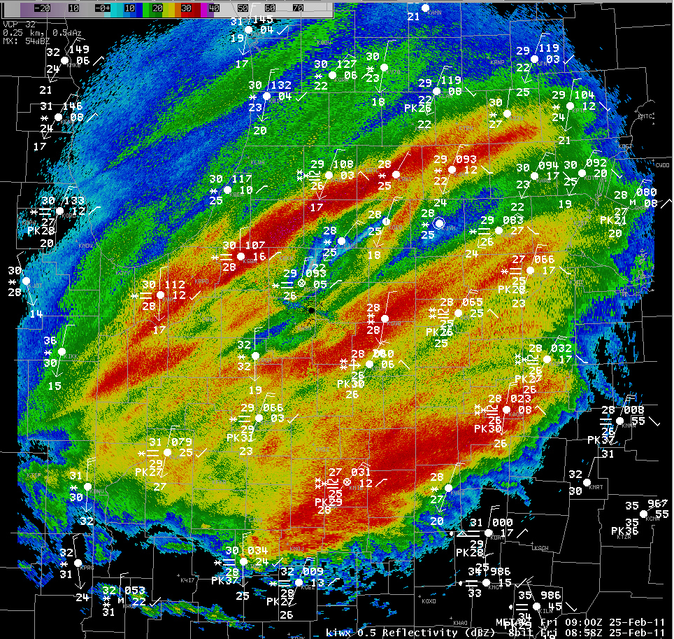 |
Radar and Observations at 4 am EST Feb 25th |
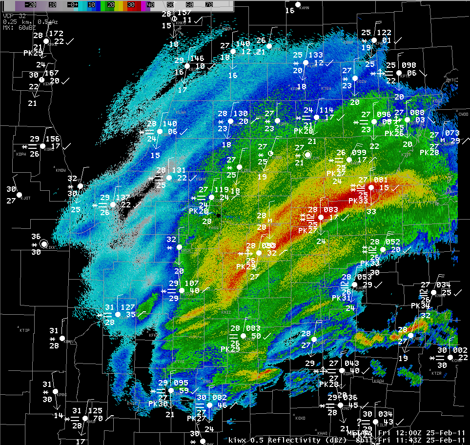 |
Radar and Observations at 7 am EST February 25th |
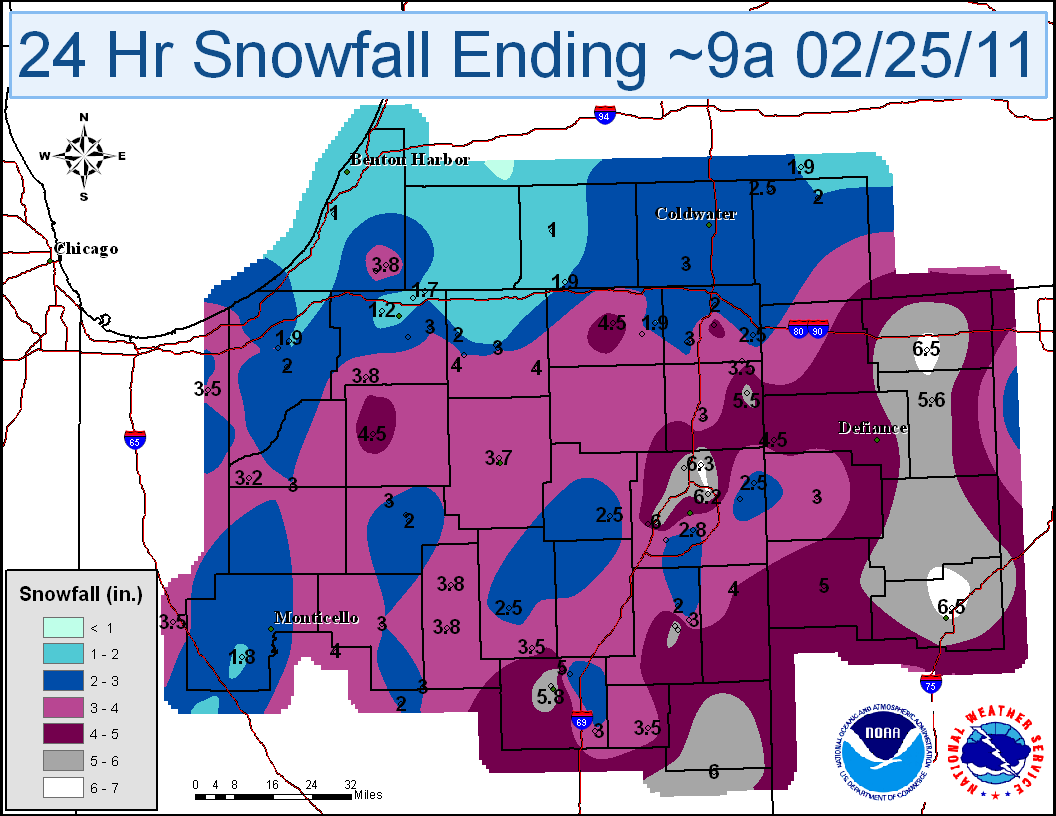
Click here for a table of daily snowfall amounts.
LOCATION                             VALUE
WAUSEON                                6.5
LIMA 2.7 NE                            6.5
LEO 2.2 NW                             6.3
FORT WAYNE 7.0 NE                      6.2
RIDGEVILLE 1 N                         6.0
TOLEDO 2.4 ENE                         6.0
FORT WAYNE 5.4 WSW                     6.0
MARION 2 N                             5.8
MUNCIE 2.0 ESE                         5.8
NAPOLEON 0.3 NNW                       5.6
BLUFFTON 1 N                           5.6
GENOA 1.1 ENE                          5.5
BLUFFTON 0.9 SE                        5.5
BUTLER 0.5 NNE                         5.5
HUNTERTOWN 2.6 ESE                     5.4
VAN WERT 1 S                           5.0
PERRYSBURG 6.0 SE                      5.0
OREGON 2.8 SSW                         5.0
ATLANTA 4.1 ENE                        5.0
MARION 5.4 NNE                         5.0
MONROE 3.1 SW                          4.9
ANGOLA                                 4.7
SYLVANIA 1.4 WNW                       4.5
PLYMOUTH 2.5 WSW                       4.5
LAGRANGE 1.3 ENE                       4.5
FORT WAYNE 7.1 WSW                     4.5
HICKSVILLE                             4.5
NEWPORT 3.1 SE                         4.4
UPPER SANDUSKY 0.4 SSW                 4.3
BELLEVUE 4.9 S                         4.0
PIQUA 0.8 SSE                          4.0
PORTAGE 0.9 ESE                        4.0
MILLERSBURG 0.5 SW                     4.0
WAKARUSA 0.3 WSW                       4.0
CAMDEN 4.9 NNE                         4.0
DECATUR 1 N                            4.0
PORTER 0.6 S                           3.9
PERU                                   3.8
NILES 2.7 W                            3.8
WALKERTON 5.7 ENE                      3.8
DENVER 1.3 NE                          3.8
COVINGTON 0.4 WNW                      3.8
BUCHANAN 1.4 ESE                       3.7
WARSAW 1.1 NNW                         3.7
DE MOTTE 0.8 NNW                       3.7
KOKOMO 6.8 W                           3.6
LA FONTAINE 1.1 NW                     3.5
HAMILTON 1.7 E                         3.5
VALPARAISO 2.0 ESE                     3.5
CHESTERTON 1.4 ENE                     3.5
LAGRANGE 7.2 ESE                       3.5
REMINGTON 0.3 N                        3.5
HARTFORD CITY 4 ESE                    3.5
RENSSELAER                             3.2
NORTH JUDSON 4 W                       3.2
PORT CLINTON 2.5 W                     3.1
LOWELL                                 3.1
LAFAYETTE 2.2 S                        3.1
LA PORTE 1.6 SW                        3.1
PAULDING                               3.0
MARION 4.2 SSE                         3.0
BRADFORD 2.3 NW                        3.0
BRONSON 5.9 SE                         3.0
BLUFFTON 3.0 ENE                       3.0
LAFAYETTE 2.2 NE                       3.0
LAFAYETTE 1.2 SSW                      3.0
NORTH JUDSON 5.7 ESE                   3.0
HUDSON 4.6 N                           3.0
MISHAWAKA 2.5 SE                       3.0
VALPARAISO 1.8 N                       3.0
VALPARAISO 0.9 NNW                     3.0
VALPARAISO 5.7 WSW                     3.0
DE MOTTE 4.1 SW                        3.0
KOKOMO 4.3 SW                          3.0
UPLAND 2.4 SSE                         3.0
ROCHESTER 7.0 NW                       3.0
GOSHEN 1.2 WNW                         3.0
AUBURN 0.8 NE                          3.0
LOGANSPORT 1.7 ENE                     3.0
GALVESTON 1.3 ESE                      3.0
HUDSON 4.1 NNW                         2.9
LAKES OF THE FOUR SEASONS 1.5 NNE      2.9
FORT WAYNE ASOS                        2.9
LAFAYETTE 0.5 S                        2.8
VALPARAISO 1.4 WNW                     2.8
FORT WAYNE 4.0 SE                      2.8
VALPARAISO 0.4 SSW                     2.7
WAKARUSA 2.4 NNE                       2.6
WOODBURN 3 N                           2.5
ANNA 3.1 NNW                           2.5
LITCHFIELD 0.3 ENE                     2.5
COLUMBIA CITY 6.6 SSE                  2.5
WABASH 0.3 NNW                         2.5
ANGOLA 8.7 ESE                         2.5
SOUTH BEND 4.6 SE                      2.5
VALPARAISO 0.6 SE                      2.5
LAKES OF THE FOUR SEASONS 0.5 ESE      2.5
VALPARAISO 1.4 ENE                     2.5
ATTICA 3.4 SSW                         2.5
ROCHESTER 2.4 NW                       2.5
WOODBURN 2.8 WSW                       2.5
DETROIT INT AIRPORT                    2.5
VALPARAISO 4.6 NNE                     2.4
INDIANAPOLIS                           2.2
WEST LAFAYETTE 5.1 WSW                 2.1
CROWN POINT 7.8 E                      2.1
WEST LAFAYETTE 6 NW                    2.0
ROCHESTER                              2.0
ADRIAN 6.4 ENE                         2.0
ADRIAN 6.4 ENE                         2.0
KALAMAZOO 6.0 SW                       2.0
JONESVILLE 5.9 ENE                     2.0
KINGSBURY 1 N                          2.0
BLUFFTON 4.1 N                         2.0
ANGOLA 4.1 N                           2.0
HEBRON 3.7 NE                          2.0
VALPARAISO 5.5 SSW                     2.0
KINGSBURY 0.3 WNW                      2.0
KOKOMO 7.2 WNW                         2.0
MARION 5.6 NE                          2.0
ELKHART 3.1 SSE                        2.0
WHITE PIGEON 3.4 ESE                   1.9
HANOVER 3.8 W                          1.9
LA PORTE 1.2 E                         1.9
LAGRANGE 9.9 E                         1.9
CHALMERS 5 W                           1.8
OTTERBEIN 2.3 SE                       1.7
GRANGER 1.6 N                          1.7
GRANGER 2.9 W                          1.6
NORTHWOOD 2.8 ENE                      1.5
DUBLIN 3.2 ENE                         1.5
PLYMOUTH 5.4 W                         1.5
ANN ARBOR 2.1 WNW                      1.5
HOLLAND 3.8 W                          1.5
GOSHEN 1.9 NW                          1.5
VALPARAISO 1.8 NW                      1.4
RIVES JUNCTION 4.0 NW                  1.3
SOUTH BEND ASOS                        1.2
THREE RIVERS                           1.0
BOWLING GREEN 1.7 NW                   1.0
HOLLAND 3.9 NNE                        1.0
JACKSON 3.2 W                          1.0
STEVENSVILLE 1.7 SSE                   1.0
DAYTON OHIO                            0.9
ANN ARBOR 3.1 SE                       0.8
WAYLAND 2.0 W                          0.7
PAW PAW 3.6 NNE                        0.5
HOLLAND 4.3 NNW                        0.5
GRAND RAPIDS ASOS                      0.5
BLOOMINGDALE                           0.5
O'HARE INTERNATIONAL APT               0.4
VALPARAISO 9.4 SSW                     0.4
WALKER 3.2 W                           0.3
ALLENDALE 1.3 SSW                      0.3
LANSING ASOS                           0.3
NEW ALBANY 2.8 SSE                     0.2
MARBLE CLIFF 1.1 WNW                   0.2
WESTERVILLE 0.2 WNW                      T
MILWAUKEE                                T
MUSKEGON ASOS                          0.0
BUTLER 1 SE                            0.0
LF 2/25/11
Hazards
Heat Related
Winter Related
Watch/Warning
Outlook
Storm Reports
Storm Prediction Center
Submit a Report
Event Ready
Climate
FWA Daily
SBN Daily
FWA Monthly
SBN Monthly
CoCoRaHS
Spring Frost Climatology
Fall Frost Climatology
Severe Climatology
Local Information
Skywarn
COOP
Our Office
WSR-88D
Headline Criteria
NOAA Weather Radio
Weather History
Probabilistic Snowfall
Public Information Statement
Social Media Feeds
Weather Events Page
US Dept of Commerce
National Oceanic and Atmospheric Administration
National Weather Service
Northern Indiana
7506 E 850 N
Syracuse, IN 46567
574-834-1104
Comments? Questions? Please Contact Us.

