Northern Indiana
Weather Forecast Office
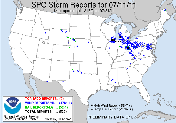
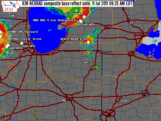
A complex of severe thunderstorms raced across the region on July 11, producing widespread wind damage in portions of northern Indiana, southern Michigan, and northwest Ohio. The thunderstorm complex developed on the northern periphery of a staunch upper level ridge in place across the southern US. A middle atmospheric disturbance ejected out of the western US and supported the development of thunderstorms across eastern Colorado, northwest Kansas, and southwest Nebraska. The thunderstorm’s outflow congealed and a Mesoscale Convective System developed. The thunderstorm complex remained on an eastward trajectory, following the gradient of instability and the mid-level atmospheric flow, failing to build south into the most unstable air due to intense low level capping in place. Hence, this type of system is commonly referred to as a “ridge rider” as the system remains on the edge of the upper level ridge as they propagate. This complex of severe thunderstorms produced wind damage from southwest Nebraska to Maryland, approximately 1,400 miles with the strongest winds from central Iowa and east. A convective system that produces widespread wind damage for several miles is known as a derecho. (Click here to learn more about derechos.) Winds gusted as high as 85 mph, with damage to structures and trees. The hardest hit part of the local area was along the Indiana and Michigan state line. A radar overview and map of storm reports is included below.
 |
|
Hazards
Heat Related
Winter Related
Watch/Warning
Outlook
Storm Reports
Storm Prediction Center
Submit a Report
Event Ready
Climate
FWA Daily
SBN Daily
FWA Monthly
SBN Monthly
CoCoRaHS
Spring Frost Climatology
Fall Frost Climatology
Severe Climatology
Local Information
Skywarn
COOP
Our Office
WSR-88D
Headline Criteria
NOAA Weather Radio
Weather History
Probabilistic Snowfall
Public Information Statement
Social Media Feeds
Weather Events Page
US Dept of Commerce
National Oceanic and Atmospheric Administration
National Weather Service
Northern Indiana
7506 E 850 N
Syracuse, IN 46567
574-834-1104
Comments? Questions? Please Contact Us.