Thunderstorms fired ahead of a cold front across the local area during the afternoon and evening hours on Wednesday, August 7th. While most of the storms remained below severe limits with mainly heavy rainfall and frequent lightning, a few of the storms did pulse up briefly to severe levels with large hail (1-1.5" in diameter) and a few damaging wind gusts in excess of 60 mph.
We also received reports that tornado sirens were sounded in the Goshen area due to public reports of a funnel cloud and/or tornado. These turned out to be false reports as low-hanging clouds were mistaken for a funnel cloud. The clouds showed no rotation and nothing in the way of rotation was seen on the radar. No tornado warnings were in effect at the time and no damage was found in this area.
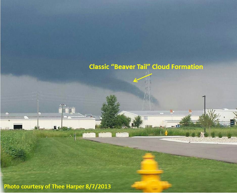
After viewing pictures of the cloud, it was confirmed to be what meteorologists refer to as a classic "beaver tail" cloud. This is a condensation cloud formed by air being cooled as it gets pulled up into the updraft of a thunderstorm. The definition from the NWS Glossary for Storm Spotters is as follows:
Beaver('s) Tail - [Slang], a particular type of inflow band with a relatively broad, flat appearance suggestive of a beaver's tail. It is attached to a supercell's general updraft and is oriented roughly parallel to the pseudo-warm front, i.e., usually east to west or southeast to northwest. As with any inflow band, cloud elements move toward the updraft, i.e., toward the west or northwest. Its size and shape change as the strength of the inflow changes. See also inflow stinger.
Spotters should note the distinction between a beaver tail and a tail cloud. A "true" tail cloud typically is attached to the wall cloud and has a cloud base at about the same level as the wall cloud itself. A beaver tail, on the other hand, is not attached to the wall cloud and has a cloud base at about the same height as the updraft base (which by definition is higher than the wall cloud). Unlike the beaver tail, the tail cloud forms from air that is flowing from the storm's main precipitation cascade region (or outflow region). Thus, it can be oriented at a large angle to the pseudo-warm front.
Here is a picture of the cloud in question from Thee Harper in Goshen. This was posted to our Facebook page on Wednesday. The picture shows this tail clearly with the rain shaft is seen left of the cloud feature and drier "brighter" air to the right. To the untrained eye, this would look like a funnel cloud so all the reports are understandable.
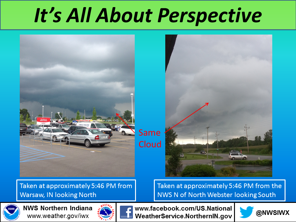
When viewing clouds like this, it is always best to stop and watch the feature for a minute or two. If the cloud is not rotating, it is not a tornado or a funnel cloud. Just because a cloud looks scary from one angle, doesn't mean it's something to be concerned about! Here's a great graphic showing how it's all about perspective. The picture on the left was taken from the Warsaw Meijer on Wednesday evening at the same time the picture on the right was taken from the Northern Indiana NWS office. These pictures show that a cloud can look like it is on the ground simply due to the perspective. The cloud on the left could be mistaken as a funnel cloud, but there was no rotation. It moved directly above the office! The bottom of that cloud is actually the exact same cloud that is above the white van in the photo on the right. Pretty cool!
Here is an excerpt from the Storm Prediction Center on how to tell the difference between scary looking clouds and funnel clouds vs tornadoes. For the full Tornado FAQ check out this page from the Storm Prediction Center.
 I saw a low-hanging cloud in a thunderstorm. Was it a tornado? Without being there or seeing good video of it, I can't say. Many low-hanging clouds are not tornadoes, but sometimes are wrongly reported as tornadoes anyway. The most important things to look for when you see a suspicious cloud feature are:
It is common to have one without the other. Many thunderstorms produce dust plumes in their outflow; these tend to move in one direction and not rotate. In gustnadoes, there is spinning motion at ground level but not at cloud base (therefore, not a tornado). If the ground is wet enough, or the circulation weak enough, there may not be any debris under a rotating cloud base. But persistent rotation in the cloud base is potentially very dangerous and should be reported. At night, also look for persistent cloud lowering to ground, especially if accompanied by a power flash.
What's the difference between a funnel cloud and a tornado? What is a funnel cloud? In a tornado, a damaging circulation is on the ground--whether or not the cloud is. The phrase, "tornado on the ground," is redundant! A tornado, by definition, is "on the ground." A true funnel cloud rotates, but has no ground contact or debris, and is not doing damage. If it is a low-hanging cloud with no rotation, it is not a funnel cloud. Caution: tornadoes can happen without a funnel; and what looks like "only" a funnel cloud may be doing damage which can't be seen from a distance. Some funnels are high-based and may never reach the surface. Still, since a funnel cloud might quickly become a tornado (remember rotation!), it should be reported by spotters.
You can learn how to tell the difference between "scary-looking" clouds and clouds which may actually pose a danger by checking out our online storm spotter training! This is available year-round here and can help you learn more about thunderstorms and the cloud features associated with them! Also, you can check out NWS Norman's YouTube Playlist on Storm Spotter Training which features some great videos on identifying cloud features.
Published 8/8/2013
CEO/NG/ESB

