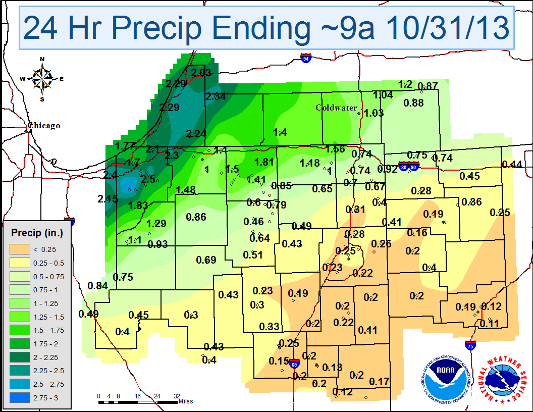
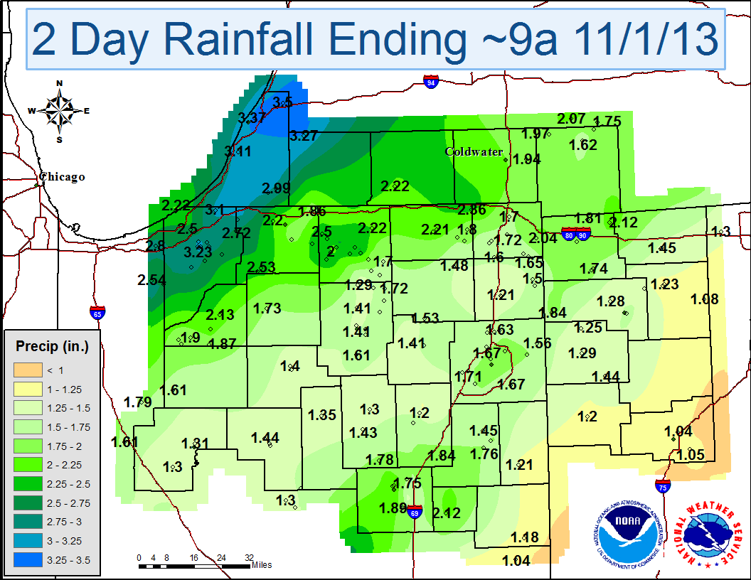
A strong low pressure system and associated cold front moved across the region on the night of October 30th through October 31st, 2013. The system brought heavy rainfall to the local area with storm total precipitation in the 1 to 3.5 inch range. It was the wettest Halloween on record at Fort Wayne with 1.73" and the 2nd wettest at South Bend with 1.20." Gusty winds of 25-45 mph also accompanied the system, making for a wet and windy Halloween.
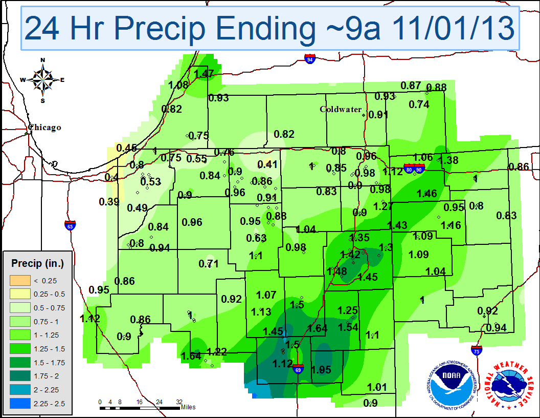
The maps and table below show rainfall totals ending ~10am EDT November 1st.
| October 30, 2013 | October 31, 2013 |
 |
 |
| Location | Amount | Time/Date |
| ...Indiana... | ||
| ...Adams... | ||
| 1 Wsw Berne | 1.21 | 0500 AM 11/01 |
| ...Allen... | ||
| Fort Wayne Internat | 1.83 | 0800 AM 11/01 |
| Bunche Elementary Sc | 1.66 | 0900 AM 11/01 |
| City/County Building | 1.65 | 0900 AM 11/01 |
| Woodburn 3N | 1.56 | 0700 AM 11/01 |
| Fairfield Elementary | 1.52 | 0900 AM 11/01 |
| Spy Run At Franke Pa | 1.42 | 0900 AM 11/01 |
| Harrison Hill Elemen | 1.38 | 0900 AM 11/01 |
| Study Elementary Sch | 1.37 | 0900 AM 11/01 |
| Irwin Elementary Sch | 1.32 | 0900 AM 11/01 |
| Price Elementary Sch | 1.3 | 0900 AM 11/01 |
| Maumee River At Anth | 1.26 | 0900 AM 11/01 |
| Adams Elementary Sch | 1.26 | 0900 AM 11/01 |
| Dupont Library - Cso | 1.26 | 0900 AM 11/01 |
| Brentwood Elementary | 1.22 | 0900 AM 11/01 |
| Belle Vista Bridge | 1.15 | 0900 AM 11/01 |
| Maumee River At Cols | 1 | 0900 AM 11/01 |
| ...De Kalb... | ||
| Butler 1Se | 1.62 | 0715 AM 11/01 |
| Garrett | 1.48 | 0700 AM 11/01 |
| 1 Ene Auburn | 1.21 | 0600 AM 11/01 |
| ...Elkhart... | ||
| 3 Nnw Southwest | 2.56 | 0800 AM 11/01 |
| 1 N Waterford Mills | 2.52 | 0500 AM 11/01 |
| Wakarusa | 2.51 | 0700 AM 11/01 |
| 1 Wnw Jimtown | 2.5 | 0600 AM 11/01 |
| Elkhart Public Works | 1200 AM 11/01 | |
| Goshen Municipal Air | 1.91 | 0800 AM 11/01 |
| ...Grant... | ||
| Marion 2N | 2.12 | 0700 AM 11/01 |
| 1 E Jonesboro | 1.89 | 0700 AM 11/01 |
| Municipal Apt | 1.3 | 0755 AM 11/01 |
| ...Huntington... | ||
| Huntington | 1.66 | 0730 AM 11/01 |
| ...Kosciusko... | ||
| 1 Nne Winona Lake | 1.56 | 0800 AM 11/01 |
| 2 N North Webster | 1.55 | 0800 AM 11/01 |
| Northern Indiana Wfo | 1.51 | 0800 AM 11/01 |
| Leesburg | 1.41 | 0600 AM 11/01 |
| 2 N North Webster | 1.17 | 1028 AM 11/01 |
| 1 Sw Burket | 1.08 | 1036 AM 11/01 |
| ...La Porte... | ||
| Laporte | 2.98 | 0100 AM 11/01 |
| Kingsbury 1N | 2.65 | 0730 AM 11/01 |
| Kingsbury | 2.65 | 0800 AM 11/01 |
| 1 Wsw Long Beach | 2.22 | 0800 AM 11/01 |
| La Porte | 1.95 | 0755 AM 11/01 |
| ...Lagrange... | ||
| 1 Ene Brushy Prairie | 1.8 | 0600 AM 11/01 |
| ...Marshall... | ||
| Plymouth | 1.93 | 1037 AM 11/01 |
| Plymouth | 1.92 | 0500 AM 11/01 |
| Plymouth | 1.68 | 1033 AM 11/01 |
| ...Miami... | ||
| 1 Ssw Grissom Afb | 1.49 | 0800 AM 11/01 |
| Peru | 1.41 | 0535 AM 11/01 |
| 1 Ene Denver | 1.35 | 0700 AM 11/01 |
| ...Noble... | ||
| Kendallville | 1.63 | 0700 AM 11/01 |
| 1 E Big Lake | 1.25 | 1026 AM 11/01 |
| ...Pulaski... | ||
| Francesville | 1.61 | 0800 AM 11/01 |
| ...St. Joseph... | ||
| New Carlisle | 3.05 | 0700 AM 11/01 |
| 5 Ssw Osceola | 2.41 | 0600 AM 11/01 |
| South Bend Regional | 2.2 | 0800 AM 11/01 |
| South Bend Wwtp | 2.19 | 0445 AM 11/01 |
| 1 W Chain-O-Lakes | 2.04 | 1030 AM 11/01 |
| ...Starke... | ||
| Knox Wwtp | 2.13 | 0800 AM 11/01 |
| North Judson 3S | 1.84 | 0800 AM 11/01 |
| ...Steuben... | ||
| 2 E Hamilton | 1.65 | 0700 AM 11/01 |
| 2 Wsw Golden Lake | 1.57 | 0600 AM 11/01 |
| Angola | 1.56 | 0700 AM 11/01 |
| ...Wabash... | ||
| 1 Sw Wabash | 1.36 | 1030 AM 11/01 |
| Urbana | 1.3 | 0600 AM 11/01 |
| ...Wells... | ||
| 2 Sw Craigville | 1.81 | 0400 AM 11/01 |
| Bluffton--Main St. B | 1.41 | 0848 AM 11/01 |
| ...White... | ||
| Monticello | 1.31 | 0600 AM 11/01 |
| Chalmers 5W | 1.3 | 0600 AM 11/01 |
| ...Whitley... | ||
| Columbia City | 1.52 | 0700 AM 11/01 |
| ...Michigan... | ||
| ...Berrien... | ||
| 1 Nne Watervliet | 3.5 | 0700 AM 11/01 |
| Southwest Michigan R | 3.37 | 0800 AM 11/01 |
| 3 W Niles | 2.99 | 0800 AM 11/01 |
| ...Branch... | ||
| Coldwater St School | 1.89 | 1200 AM 11/01 |
| ...Cass... | ||
| 1 Ese Magician Lake | 3.27 | 0926 AM 11/01 |
| 3 Nw Granger | 1.6 | 1026 AM 11/01 |
| ...Hillsdale... | ||
| 4 Nw North Adams | 1.62 | 0600 AM 11/01 |
| ...Ohio... | ||
| ...Allen... | ||
| Lima Allen County Ai | 1.05 | 0800 AM 11/01 |
| ...Defiance... | ||
| Hicksville | 1.84 | 0630 AM 11/01 |
| Defiance Memorial Ai | 1.28 | 0800 AM 11/01 |
| ...Henry... | ||
| 3 Se Mcclure | 1.08 | 0700 AM 11/01 |
| ...Paulding... | ||
| Grover Hill | 1.44 | 0700 AM 11/01 |
| ...Williams... | ||
| Montpelier | 1.92 | 0707 AM 11/01 |
| Stryker | 1.9 | 0700 AM 11/01 |
| Bryan 2Se | 1.88 | 0800 AM 11/01 |
The table below shows peak sustained winds and peak wind gusts for October 31st.
| LOCATION | Peak Sustained Wind / Time | Peak Wind Gust / Time |
| Indiana... | ||
| Warsaw | 23 MPH / 315 AM | 33 MPH / 415 AM |
| Auburn | 24 MPH / 335 AM | 31 MPH / 335 AM |
| Fort Wayne | 24 MPH / 454 AM | 41 MPH / 339 AM |
| Logansport | 28 MPH / 235 AM | 40 MPH / 155 AM |
| Goshen | 32 MPH / 1102 PM | 41 MPH / 1059 PM |
| Grissom Afb | 28 MPH / 238 AM | 36 MPH / 818 PM |
| Knox | 26 MPH / 235 AM | 35 MPH / 235 AM |
| Michigan City | 22 MPH / 435 AM | 33 MPH / 415 AM |
| Laporte | 22 MPH / 215 AM | 30 MPH / 1015 PM |
| Marion | 28 MPH / 335 AM | 38 MPH / 1015 PM |
| Rochester | 23 MPH / 315 AM | 32 MPH / 355 AM |
| South Bend | 26 MPH / 309 AM | 37 MPH / 443 AM |
| Michigan... | ||
| Benton Harbor | 32 MPH / 122 AM | 45 MPH / 332 AM |
| Three Rivers | 20 MPH / 115 PM | 31 MPH / 1155 PM |
| Coldwater | 25 MPH / 1115 PM | 37 MPH / 315 AM |
| Hillsdale | 24 MPH / 515 AM | 33 MPH / 515 AM |
| Sturgis | 23 MPH / 555 AM | 36 MPH / 834 AM |
| Ohio... | ||
| Defiance | 18 MPH / 845 PM | 35 MPH / 454 AM |
| Lima | 40 MPH / 1130 PM | 47 MPH / 1129 PM |
Page Published 11/1/2013 11:45am
CEO

