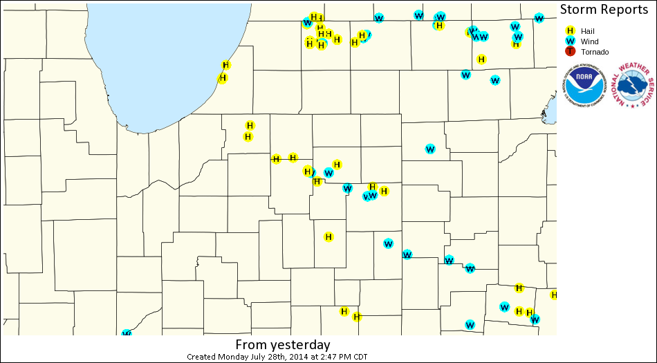
A strong upper level trough and jet streak combined with a frontal boundary moving across the area to produce showers and thunderstorms across much of northern Indiana, southern lower Michigan, and northwest Ohio Sunday afternoon. The combination of warm surface temperatures and cooling air aloft provided enough instability with this system for scattered severe thunderstorms in the form of damaging winds and large hail. Most of the severe weather occurred along a corridor from southern Elkhart/northern Kosciusko county, extending southeastward across northeast Indiana into northern Allen IN county. Large hail was also reported in western Berrien county MI, along with the central portions of St.Joseph county IN, with reports of golf ball hail across Berrien county MI and in northern Whitley county IN. The severe weather threat transitioned to mainly isolated damaging winds as the storms tracked southeast of Fort Wayne and into northwest Ohio.
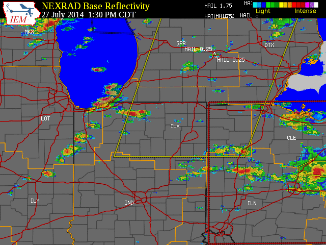
The initial storms which developed across northwest Indiana and southwest lower Michigan posed mainly a large hail threat. Golf ball hail was reported near Stevensville, MI with a storm that came off Lake Michigan, while the initial storms which developed in central St. Joseph IN county produced up to half dollar sized hail just northwest of Woodland, IN. These storms across St Joseph IN county would also produce half dollar sized hail as they tracked into the Nappanee, IN area. Reports of damaging wind gusts began to increase as these thunderstorms matured into northeast Kosciusko, southwest Noble, and northern Whitley counties. Two separate instances of nickel to quarter sized hail were observed at the National Weather Service Northern Indiana with these storms. As the storms reached far northeast Indiana and northwest Ohio, damaging winds became the main concern. The National Weather Service would like to thank emergency management, trained spotters, local fire departments, media, amateur radio operators, law enforcement, and the public for timely reports during this event.
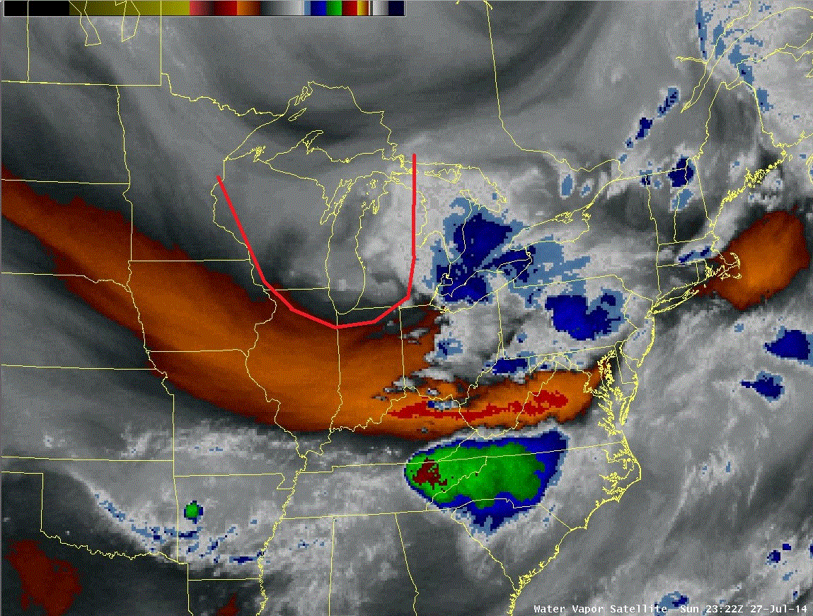
A strong upper level trough dropped southeast into the Great Lakes on Sunday which resulted in forcing upward motion in the atmosphere. This upper level trough can be seen in the water vapor imagery below. The initial thunderstorms developed along a surface trough, where convergent winds helped initiate the thunderstorms. Severe thunderstorms developed ahead of this main broken line of thunderstorms across northeast Illinois and northwest Indiana, and produced some large hail in the Lakeville, IN area. These thunderstorms ahead of the main broken line were focused along a west to east boundary which was enhanced by the influence of southern Lake Michigan. In addition to the forcing for vertical motion, warm surface temperatures in the 80's combined with cooling temperatures aloft and plenty of low level moisture resulted in unstable conditions in the afternoon that fed the intensification of these storms as they entered northern Indiana.
The images and descriptions below give an overview of some of the conditions described above that were favorable for severe thunderstorms Sunday.
 |
 |
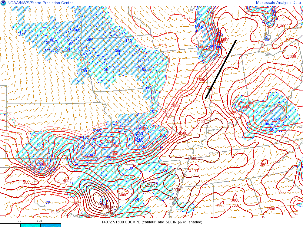 |
| Water Vapor Imagery (~7pm EDT) shows the strong upper level trough which moved into the Great Lakes region by evening (outlined in red). Storms developed in advance of this feature. Cold air aloft with the trough also contributed to greater afternoon instability. | Visible Satellite (~1230pm EDT) shows the developing broken line of showers and thunderstorms across northeast Illinois which eventually tracked into the area. Additional storms became severe ahead of this line in the vicinity of another boundary enhanced by Lake Michigan. | Surface-based CAPE (2pm EDT) or Convective Available Potential Energy is the potential buoyancy air parcels will exhibit and thus a measure of instability. Note the axis of stronger instability (2500-3000 J/kg CAPE's) across N. Indiana into SW lower Michigan (labeled with black line). Storms that developed across northeast Illinois intensified as they encountered this instability axis. |