Overview
A tropical air mass worked north out of the Gulf states as weak low pressure deepened and moved into the western Great Lakes. The high moisture content, combined with very efficient rainfall processes allowed for a period of widespread rain across the forecast area. As the main area moved north, additional stronger showers developed and moved over the same area, across northwestern Marshall county into much of St. Joseph County Indiana. Localized rain amounts exceeded 8 inches. In addition to the flooding, a low topped supercell raised havoc mainly across portions of central Indiana. The supercell moved into portions of Grant, Wabash and Huntington counties were numerous funnel clouds sighting were reported and recorded. More detail on all of these events can be found throughout the web page.Flooding
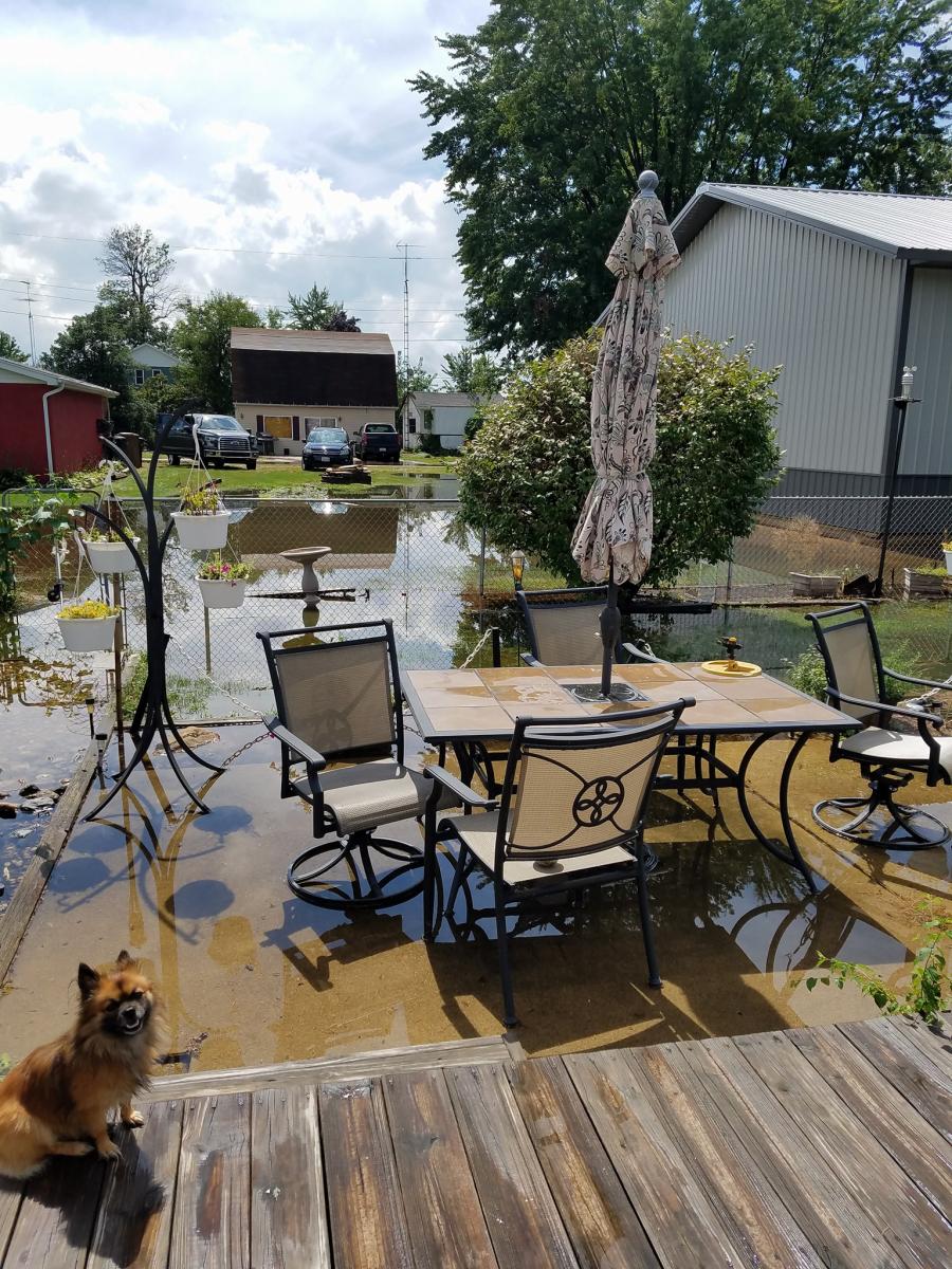
Rainfall rates of 1 to 2 inches per hour over several hours caused rapid runoff into low areas, rivers and streams. Stormwater systems in South Bend and surrounding areas were quickly overwhelmed with widespread flooding and even occurrences of flash flooding as water levels quickly rose and sending several feet of water into some city streets, forcing at least a dozen water rescues.
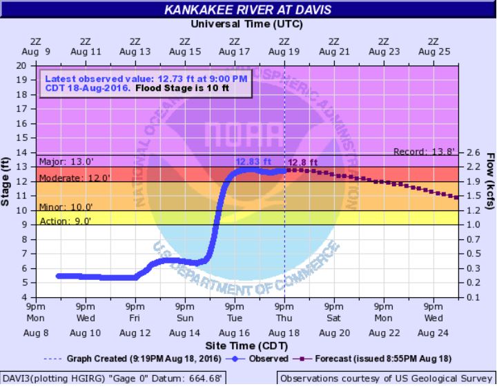
Hydrographs
 |
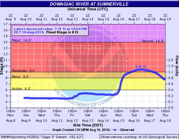 |
| Kankakee River At Davis, IN | Dowagiac River at Sumnerville, MI |
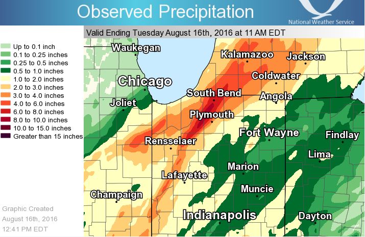
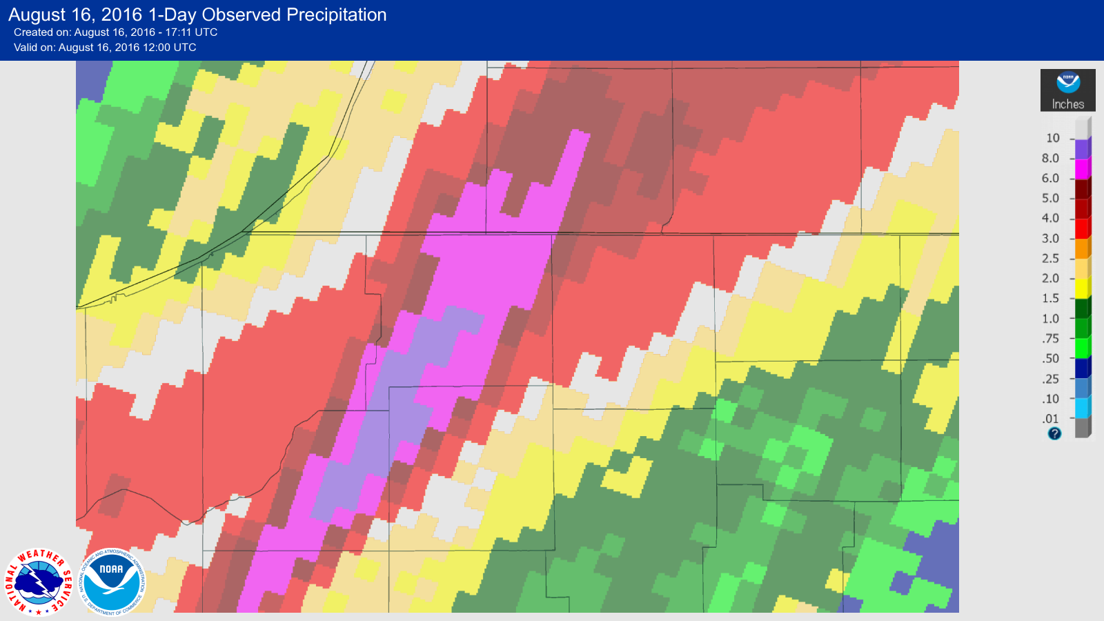
Rainfall Images
 |
 |
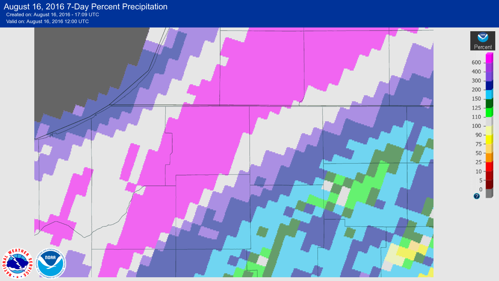 |
| Area Map of 24 Hour Rainfall Totals | Zoomed in Map of Heaviest Rainfall | Percent of Normal |
Low Topped Supercell and Funnel Clouds
NUMEROUS REPORTS...INCLUDING PICTURE AND VIDEO FOOTAGE...HAVE BEEN SHARED OF A WELL DEVELOPED FUNNEL CLOUD NEAR
THE GRANT/HOWARD/MIAMI COUNTY LINE...NORTHWEST OF SWAYZEE. STAFF FROM GRANT AND MIAMI COUNTY EMA AS WELL AS THE
NWS DID A ROADSIDE SURVEY IN THE AREA BETWEEN SWAYZEE...CONVERSE AND JALAPA. A BARN ON EAST COUNTY ROAD 300 N
IN HOWARD COUNTY...NEAR THE GRANT/HOWARD COUNTY LINE...SUFFERED MINOR DAMAGE. AREAL FOOTAGE FROM WTHR SHOWED A
BEAN FIELD SUFFERING DAMAGE AS WELL TO THE NORTHEAST OF THE BARN. INFORMATION FROM THE PILOT...EMA OFFICIALS
AND THE NWS SUGGESTS THAT THE DAMAGE ENDED NEAR THE COUNTY LINE. WHILE THE FUNNEL WAS IN CLOSE PROXIMITY TO THE
GROUND...CURRENT INDICATIONS ARE THAT THERE WAS NO TOUCHDOWN IN GRANT COUNTY.

THE CELL CONTINUED NORTHEAST AND RAPIDLY INTENSIFIED AS IT APPROACHED ANDREWS IN HUNTINGTON COUNTY. EMERGENCY
MANAGEMENT OFFICIALS...SPOTTERS AND A OFF DUTY NWS METEOROLOGIST WERE IN THE AREA. WHILE FUNNEL WERE STILL
OBSERVED...THERE HAS BEEN NO REPORTS OF DAMAGE.
Photos & Video:
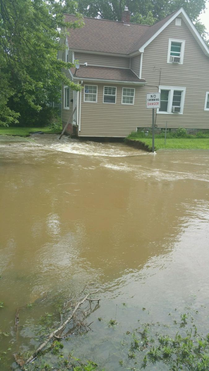
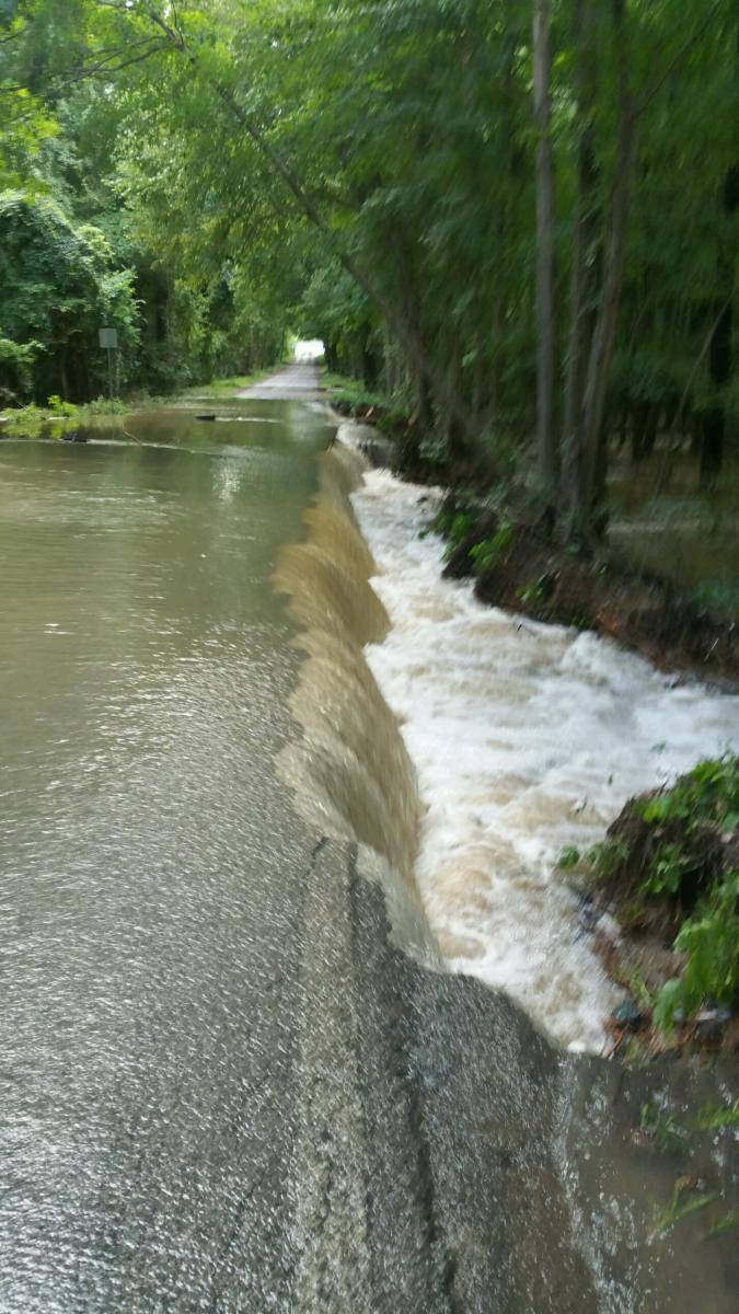
Flooding: South Bend
 |
.jpg) |
 |
| Sink Hole near Residence Source: St. Joseph County EMA |
Severe Street Flooding Source: St. Joseph County EMA |
Partial Washout Source: St. Joseph County EMA |
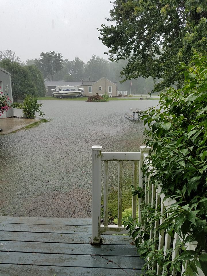
Flooding: Starke County
 |
 |
| Bass Lake Source: Christine Zaremba |
Bass Lake Source: Christine Zaremba |
Radar:
Header
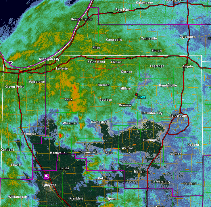 |
| Radar Loop |
Storm Reports
PRELIMINARY LOCAL STORM REPORT...SUMMARY
NATIONAL WEATHER SERVICE NORTHERN INDIANA
327 PM EDT TUE AUG 16 2016
..TIME... ...EVENT... ...CITY LOCATION... ...LAT.LON...
..DATE... ....MAG.... ..COUNTY LOCATION..ST.. ...SOURCE....
..REMARKS..
1004 AM FLOOD 2 NNE INWOOD 41.34N 86.19W
08/16/2016 MARSHALL IN EMERGENCY MNGR
REPORTS OF SEVERAL ROAD CLOSURES ACROSS
MARSHALL COUNTY. SPECIFICALLY TAMARACK RD
NORTH OF US 6, 6TH RD WEST OF QUEEN RD, 5TH
RD BETWEEN HAWTHORN RD AND GRAPE RD, 1B RD
AT OAK RD.
0100 AM FLASH FLOOD SOUTH BEND 41.68N 86.27W
08/16/2016 ST. JOSEPH IN BROADCAST MEDIA
NUMEROUS ROADS IMPACTED BY HIGH WATER WITH
AT LEAST 12 CLOSED. VEHICLES STRANDED WITH
SOME RESCUES NEEDED DURING THE EVENT. AT
LEAST 2 HOMES SUFFERED FOUNDATION DAMAGE. .
1255 AM NON-TSTM WND DMG 1 ENE MILFORD 41.41N 85.83W
08/16/2016 KOSCIUSKO IN NWS EMPLOYEE
2-3 FT DIAMETER HEALTHY OAK TREE SNAPPED
OFF. .
1205 AM FLASH FLOOD 1 NW ROSELAND 41.72N 86.26W
08/16/2016 ST. JOSEPH IN BROADCAST MEDIA
MULTIPLE REPORTS OF ROAD CLOSURES AND
STRANDED VEHICLES/VEHICLE RESCUES IN THE
SOUTH BEND VICINITY.
1015 PM FLOOD 2 SW LA PORTE 41.59N 86.73W
08/15/2016 LA PORTE IN COCORAHS
SOME LOW WATER CROSSINGS FLOODED.
Rain Reports
NATIONAL WEATHER SERVICE NORTHERN INDIANA
320 PM EDT TUE AUG 16 2016

..RAINFALL REPORTS

LOCATION                     AMOUNT    TIME/DATE       LAT/LON

INDIANA


..ADAMS COUNTY

DECATUR 1N                   0.51 IN   0700 AM 08/16   40.85N/84.93W

..ALLEN COUNTY

2 NE FORT WAYNE              0.68 IN   0654 AM 08/16   41.10N/85.11W
FORT WAYNE 1.3 NNW           0.65 IN   0608 AM 08/16   41.09N/85.15W
1 N ROLLING HILLS            0.59 IN   0800 AM 08/16   41.05N/85.27W
2 ESE HUNTERTOWN             0.58 IN   0800 AM 08/16   41.21N/85.12W
4 N NEW HAVEN                0.55 IN   0700 AM 08/16   41.13N/85.03W
2 WNW LEO-CEDARVILLE         0.52 IN   0755 AM 08/16   41.22N/85.06W

..BLACKFORD COUNTY

HARTFORD CITY 4ESE           0.98 IN   0800 AM 08/16   40.44N/85.29W
HARTFORD CITY                0.84 IN   0700 AM 08/16   40.45N/85.37W
3 SW ROLL                    0.62 IN   0700 AM 08/16   40.51N/85.43W

..CASS COUNTY

2 NE DUNKIRK                 1.15 IN   0800 AM 08/16   40.78N/86.37W
YOUNG AMERICA                1.12 IN   0800 AM 08/16   40.57N/86.33W
(WA9TTB)GALVESTON 1.0 ESE    1.04 IN   0700 AM 08/16   40.57N/86.17W

..DE KALB COUNTY

GARRETT                      1.51 IN   0810 AM 08/16   41.34N/85.13W
1 S GARRETT                  1.20 IN   0611 AM 08/16   41.33N/85.13W
BUTLER 1SE                   0.81 IN   0855 AM 08/16   41.41N/84.85W

..ELKHART COUNTY

1 SE JIMTOWN                 3.98 IN   0800 AM 08/16   41.62N/86.01W
2 WSW MIDDLEBURY             3.91 IN   0700 AM 08/16   41.65N/85.75W
2 WNW GOSHEN                 3.85 IN   1017 AM 08/16   41.60N/85.88W
2 NNE WAKARUSA               3.64 IN   0700 AM 08/16   41.57N/85.99W
WAKARUSA                     3.59 IN   0700 AM 08/16   41.53N/86.02W
1 ENE GOSHEN                 3.58 IN   0800 AM 08/16   41.58N/85.81W
2 WSW GOSHEN                 3.54 IN   0700 AM 08/16   41.56N/85.88W
1 WNW JIMTOWN                3.43 IN   0600 AM 08/16   41.64N/86.04W
1 WSW GOSHEN                 3.39 IN   0700 AM 08/16   41.57N/85.85W
1 ENE ELKHART                3.36 IN   0243 PM 08/16   41.69N/85.94W
4 SSW BRISTOL                3.35 IN   0448 AM 08/16   41.67N/85.85W
1 N WATERFORD MILLS          3.00 IN   0500 AM 08/16   41.56N/85.83W
1 SW NEW PARIS               2.87 IN   0700 AM 08/16   41.49N/85.84W
3 NE OSCEOLA                 2.76 IN   0250 PM 08/16   41.71N/86.04W
MILLERSBURG                  2.12 IN   0700 AM 08/16   41.52N/85.70W
SYRACUSE 4.4 NNW             2.02 IN   0700 AM 08/16   41.48N/85.77W
GOSHEN MUNICIPAL AIRPORT     1.96 IN   0753 AM 08/16   41.53N/85.79W

..FULTON COUNTY

ROCHESTER                    1.50 IN   0700 AM 08/16   41.07N/86.21W
2 NW ROCHESTER               1.24 IN   0700 AM 08/16   41.09N/86.23W

..GRANT COUNTY

2 E JALAPA                   0.85 IN   0800 AM 08/16   40.62N/85.71W
FAIRMOUNT                    0.76 IN   0700 AM 08/16   40.42N/85.64W
3 NW SHAMROCK LAKES          0.74 IN   0700 AM 08/16   40.45N/85.45W
(KB9CRA)GAS CITY 0.3 N       0.72 IN   0700 AM 08/16   40.49N/85.61W
MARION 2N                    0.67 IN   0718 AM 08/16   40.58N/85.66W
1 SE VAN BUREN               0.56 IN   0656 AM 08/16   40.60N/85.49W
GRANT COUNTY MUNICIPAL APT   0.54 IN   0755 AM 08/16   40.48N/85.68W
HANFIELD                     0.54 IN   0600 AM 08/16   40.60N/85.59W

..HUNTINGTON COUNTY

HUNTINGTON                   0.75 IN   0700 AM 08/16   40.88N/85.51W
(WA9QGL)ANDREWS 3.2 ESE      0.75 IN   0700 AM 08/16   40.84N/85.55W
1 ENE WARREN                 0.55 IN   0700 AM 08/16   40.70N/85.40W

..JAY COUNTY

1 W BOUNDARY CITY            0.87 IN   0700 AM 08/16   40.35N/84.95W
COLLEGE CORNER               0.73 IN   0700 AM 08/16   40.40N/84.98W
1 SSW BLAINE                 0.71 IN   0700 AM 08/16   40.39N/85.06W

..KOSCIUSKO COUNTY

LAKE WAWASEE                 2.23 IN   0800 AM 08/16   41.41N/85.70W
MILFORD                      2.01 IN   0700 AM 08/16   41.42N/85.85W
SYRACUSE                     1.70 IN   0700 AM 08/16   41.41N/85.76W
2 N NORTH WEBSTER            1.57 IN   0800 AM 08/16   41.35N/85.70W
JAMES LAKE                   1.50 IN   0700 AM 08/16   41.31N/85.72W
LEESBURG                     1.48 IN   0600 AM 08/16   41.33N/85.85W
1 NNW WARSAW                 1.36 IN   0745 AM 08/16   41.25N/85.86W
2 WSW SYRACUSE               1.20 IN   0247 PM 08/16   41.41N/85.79W
WINONA LAKE                  1.18 IN   0730 AM 08/16   41.21N/85.80W
1 E WINONA LAKE              1.14 IN   0600 AM 08/16   41.22N/85.79W
TIPPECANOE LAKE              1.01 IN   0250 PM 08/16   41.33N/85.77W
2 SW WARSAW                  1.00 IN   0226 PM 08/16   41.21N/85.87W
1 E CLAYPOOL                 0.94 IN   0700 AM 08/16   41.13N/85.86W

..LA PORTE COUNTY

FISH LAKE                    6.23 IN   1100 AM 08/16   41.57N/86.55W
1 W HANNA                    5.48 IN   0900 AM 08/16   41.41N/86.81W
KINGSBURY                    5.35 IN   0800 AM 08/16   41.53N/86.70W
KINGSBURY 1N                 5.35 IN   0730 AM 08/16   41.54N/86.70W
HANNA                        5.32 IN   0900 AM 08/16   41.41N/86.78W
2 ESE LA PORTE               5.27 IN   0700 AM 08/16   41.59N/86.68W
WESTVILLE 4.7 ESE            5.05 IN   1034 AM 08/16   41.51N/86.83W
1 SW LA PORTE                4.97 IN   0710 AM 08/16   41.59N/86.73W
2 SW LA PORTE                4.92 IN   0900 AM 08/16   41.59N/86.74W
LA PORTE                     4.86 IN   0755 AM 08/16   41.57N/86.73W
1 E HANNA                    4.71 IN   0800 AM 08/16   41.41N/86.76W
(KA9WNQ)LA PORTE 1.7 SW      4.70 IN   0715 AM 08/16   41.59N/86.74W
WANATAH 2 WNW (PPAC)         4.63 IN   0800 AM 08/16   41.44N/86.93W
3 NW LA CROSSE               4.53 IN   0800 AM 08/16   41.35N/86.93W
1 W LA CROSSE                4.20 IN   0800 AM 08/16   41.32N/86.92W
2 ENE WANATAH                3.71 IN   0800 AM 08/16   41.44N/86.83W
1 NW LA PORTE                3.50 IN   0700 AM 08/16   41.62N/86.73W
1 ESE HESSTON                3.50 IN   0400 AM 08/16   41.75N/86.64W
2 WSW SPRINGVILLE            3.42 IN   0730 AM 08/16   41.67N/86.78W
1 E WATERFORD                3.24 IN   0800 AM 08/16   41.67N/86.81W

..LAGRANGE COUNTY

2 E BRUSHY PRAIRIE           2.40 IN   0710 AM 08/16   41.64N/85.20W
1 ENE LAGRANGE               2.28 IN   0500 AM 08/16   41.65N/85.40W
2 WNW ELMIRA                 1.93 IN   0700 AM 08/16   41.60N/85.24W
BRUSHY PRAIRIE               1.77 IN   0600 AM 08/16   41.65N/85.23W

..MARSHALL COUNTY

PLYMOUTH                     3.58 IN   0540 AM 08/16   41.34N/86.34W
1 N TWIN LAKES               3.18 IN   0500 AM 08/16   41.33N/86.36W
BURR OAK                     3.00 IN   0800 AM 08/16   41.26N/86.42W
LAKE OF THE WOODS            2.90 IN   1000 AM 08/16   41.43N/86.23W
BOURBON 0.4 S                2.31 IN   0600 AM 08/16   41.29N/86.12W
2 W MENTONE                  1.23 IN   0253 PM 08/16   41.18N/86.08W

..MIAMI COUNTY

1 WNW DEEDSVILLE             1.06 IN   0700 AM 08/16   40.92N/86.12W
1 SSW GRISSOM AFB            0.90 IN   0758 AM 08/16   40.65N/86.15W
PERU                         0.87 IN   0615 AM 08/16   40.76N/86.07W
1 ENE DENVER                 0.86 IN   0700 AM 08/16   40.88N/86.06W

..NOBLE COUNTY

3 N KENDALLVILLE             2.28 IN   0700 AM 08/16   41.49N/85.26W
2 E ROME CITY                1.51 IN   0700 AM 08/16   41.50N/85.31W
3 NE AVILLA                  1.48 IN   0239 PM 08/16   41.40N/85.20W
KENDALLVILLE                 1.48 IN   0700 AM 08/16   41.44N/85.26W
2 SW CROMWELL                1.41 IN   1128 AM 08/16   41.38N/85.65W
2 E ALBION                   1.24 IN   0830 AM 08/16   41.40N/85.37W
ALBION 3.7 S                 1.13 IN   0930 AM 08/16   41.34N/85.42W
1 E BIG LAKE                 1.01 IN   0700 AM 08/16   41.28N/85.47W

..PULASKI COUNTY

FRANCESVILLE                 5.72 IN   0900 AM 08/16   40.98N/86.89W
MEDARYVILLE 5N               5.33 IN   0400 AM 08/16   41.16N/86.90W
4 NW PULASKI                 3.58 IN   0800 AM 08/16   41.03N/86.70W

..ST. JOSEPH COUNTY

WALKERTON                    10.45 IN  0800 AM 08/16   41.46N/86.48W
3 SW SOUTH BEND              10.00 IN  0900 AM 08/16   41.64N/86.31W
2 WNW GULIVOIRE PARK         9.95 IN   0800 AM 08/16   41.63N/86.29W
3 NE CHAIN-O-LAKES           9.10 IN   0320 AM 08/16   41.73N/86.34W
2 NW TEEGARDEN               8.95 IN   0630 AM 08/16   41.49N/86.41W
2 N TEEGARDEN                8.82 IN   0700 AM 08/16   41.50N/86.39W
GEORGETOWN                   8.81 IN   1100 AM 08/16   41.73N/86.23W
1 E INDIAN VILLAGE           8.78 IN   1100 AM 08/16   41.71N/86.20W
SOUTH BEND INTERNATIONAL AP  8.49 IN   0754 AM 08/16   41.71N/86.32W
GRANGER                      8.48 IN   0813 AM 08/16   41.74N/86.14W
1 ENE GULIVOIRE PARK         8.04 IN   0600 AM 08/16   41.62N/86.22W
SOUTH BEND 5.9 W             7.91 IN   0700 AM 08/16   41.67N/86.38W
2 ESE MISHAWAKA              7.74 IN   0800 AM 08/16   41.65N/86.13W
SOUTH BEND WWTP              7.32 IN   0600 AM 08/16   41.72N/86.27W
1 NW OSCEOLA                 7.01 IN   0800 AM 08/16   41.68N/86.10W
2 SW BERTRAND                6.23 IN   0248 PM 08/16   41.75N/86.30W
2 S NEW CARLISLE             4.18 IN   0251 PM 08/16   41.66N/86.51W

..STARKE COUNTY

NORTH JUDSON 3S              10.24 IN  0800 AM 08/16   41.17N/86.76W
KNOX WWTP                    8.23 IN   0800 AM 08/16   41.31N/86.63W
2 NE DENHAM                  7.45 IN   0800 AM 08/16   41.18N/86.68W
OBER                         6.40 IN   0652 AM 08/16   41.27N/86.52W
3 ESE SAN PIERRE             6.05 IN   0725 AM 08/16   41.18N/86.83W
SAN PIERRE 4.1 NNE           4.20 IN   0800 AM 08/16   41.25N/86.85W

..STEUBEN COUNTY

2 ENE CROOKED LAKE           2.74 IN   0545 AM 08/16   41.70N/84.99W
ANGOLA                       2.44 IN   0700 AM 08/16   41.64N/84.99W
1 S ANGOLA                   2.30 IN   0600 AM 08/16   41.62N/85.00W
HUDSON                       2.21 IN   0716 AM 08/16   41.53N/85.08W
1 W GOLDEN LAKE              2.03 IN   0700 AM 08/16   41.60N/85.09W
METZ                         1.56 IN   0700 AM 08/16   41.61N/84.84W
1 E HAMILTON                 1.24 IN   0700 AM 08/16   41.53N/84.89W

..WABASH COUNTY

WABASH                       0.95 IN   0600 AM 08/16   40.80N/85.83W
LA FONTAINE 1.1 NW           0.92 IN   0600 AM 08/16   40.68N/85.74W
WABASH 1.5 SW                0.90 IN   0700 AM 08/16   40.78N/85.84W
SOMERSET                     0.60 IN   0245 PM 08/16   40.66N/85.81W

..WELLS COUNTY

1 NNE BLUFFTON               0.77 IN   0700 AM 08/16   40.76N/85.16W
CRAIGVILLE 2.7 NW            0.71 IN   0800 AM 08/16   40.80N/85.13W
1 E MURRAY                   0.71 IN   0700 AM 08/16   40.79N/85.17W
BLUFFTON--MAIN ST. BRIDGE    0.59 IN   0712 AM 08/16   40.74N/85.17W

..WHITE COUNTY

MONON                        4.42 IN   0245 PM 08/16   40.86N/86.88W
CHALMERS 5W                  3.93 IN   0600 AM 08/16   40.67N/86.95W
1 WNW INDIANA BEACH          3.54 IN   0240 PM 08/16   40.80N/86.79W
1 WSW INDIANA BEACH          2.96 IN   0720 AM 08/16   40.79N/86.79W
MONTICELLO 5.5 NNW           2.90 IN   0700 AM 08/16   40.82N/86.79W
NORWAY                       2.85 IN   0245 PM 08/16   40.78N/86.76W
MONTICELLO                   2.76 IN   0600 AM 08/16   40.76N/86.76W

..WHITLEY COUNTY

1 ENE PEABODY                1.27 IN   0600 AM 08/16   41.09N/85.47W
CHURUBUSCO                   1.10 IN   0144 PM 08/16   41.23N/85.32W
1 NNW TRI-LAKES              1.09 IN   0700 AM 08/16   41.24N/85.49W

MICHIGAN


..BERRIEN COUNTY

NILES                        7.90 IN   0730 AM 08/16   41.83N/86.25W
2 W NILES                    6.67 IN   0800 AM 08/16   41.84N/86.30W
BERTRAND                     6.25 IN   0759 AM 08/16   41.77N/86.26W
1 ESE BUCHANAN               5.37 IN   0700 AM 08/16   41.82N/86.34W
1 WNW BUCHANAN               5.17 IN   0700 AM 08/16   41.84N/86.39W
NEW BUFFALO 0.4 WNW          2.79 IN   0700 AM 08/16   41.79N/86.75W
STEVENSVILLE 0.9 S           2.72 IN   0700 AM 08/16   42.00N/86.52W
THREE OAKS                   2.70 IN   1000 AM 08/16   41.80N/86.61W
WATERVLIET                   2.40 IN   0700 AM 08/16   42.20N/86.25W
1 W FAIR PLAIN               2.39 IN   0700 AM 08/16   42.08N/86.48W
FAIR PLAIN                   2.20 IN   0700 AM 08/16   42.08N/86.46W
SAINT JOSEPH                 2.15 IN   0245 PM 08/16   42.10N/86.49W
SAINT JOSEPH                 2.00 IN   0720 AM 08/16   42.10N/86.49W
BENTON HARBOR AIRPORT        2.00 IN   0753 AM 08/16   42.13N/86.43W
MILLBURG                     0.77 IN   0249 PM 08/16   42.12N/86.33W

..BRANCH COUNTY

3 WSW UNION CITY             5.00 IN   1149 AM 08/16   42.06N/85.19W
1 SSW KINDERHOOK             4.40 IN   0700 AM 08/16   41.78N/85.01W
QUINCY 0.1 SSW               3.32 IN   0700 AM 08/16   41.94N/84.88W

..CASS COUNTY

BARRON LAKE                  7.01 IN   0900 AM 08/16   41.84N/86.18W
2 NW GRANGER                 6.14 IN   0246 PM 08/16   41.77N/86.17W
1 ESE MAGICIAN LAKE          4.18 IN   0708 AM 08/16   42.06N/86.14W

..HILLSDALE COUNTY

LITCHFIELD                   3.95 IN   0700 AM 08/16   42.05N/84.75W
3 NW NORTH ADAMS             3.33 IN   0700 AM 08/16   42.01N/84.56W
MOSCOW 1.0 NE                3.10 IN   0600 AM 08/16   42.06N/84.50W
HILLSDALE                    3.08 IN   0800 AM 08/16   41.94N/84.64W
HILLSDALE MUNICIPAL AIRPORT  2.01 IN   0755 AM 08/16   41.92N/84.59W
JEROME                       1.81 IN   0232 PM 08/16   42.02N/84.46W

..ST. JOSEPH COUNTY

1 E CONSTANTINE              3.90 IN   0745 AM 08/16   41.84N/85.63W
2 SSW KLINGER LAKE           3.90 IN   0700 AM 08/16   41.77N/85.55W
STURGIS                      2.10 IN   0755 AM 08/16   41.81N/85.44W

OHIO


..ALLEN COUNTY

LIMA                         1.34 IN   0220 PM 08/16   40.73N/84.12W
ELIDA                        0.62 IN   0700 AM 08/16   40.77N/84.20W
1 WSW SLABTOWN               0.61 IN   0700 AM 08/16   40.77N/84.08W
LIMA ALLEN COUNTY AIRPORT    0.53 IN   0749 AM 08/16   40.71N/84.02W
2 SSW RUSHMORE               0.53 IN   0253 PM 08/16   40.83N/84.26W

..DEFIANCE COUNTY

DEFIANCE 9.4 NE              0.70 IN   0600 AM 08/16   41.38N/84.24W

..FULTON COUNTY

4 NW TEDROW                  0.64 IN   0700 AM 08/16   41.65N/84.25W

..HENRY COUNTY

GALLUP                       0.89 IN   0700 AM 08/16   41.46N/84.15W
NAPOLEON 1NE                 0.82 IN   0900 AM 08/16   41.40N/84.11W
NAPOLEON                     0.74 IN   0800 AM 08/16   41.39N/84.14W
3 SE MCCLURE                 0.60 IN   0700 AM 08/16   41.33N/83.91W
3 S NAPOLEON                 0.50 IN   0740 AM 08/16   41.34N/84.12W

..PAULDING COUNTY

1 NW OAKWOOD                 0.97 IN   0237 PM 08/16   41.11N/84.40W
GROVER HILL                  0.92 IN   0700 AM 08/16   41.02N/84.48W

..WILLIAMS COUNTY

1 E LAKE SENECA              1.25 IN   0800 AM 08/16   41.69N/84.64W
2 S PIONEER                  0.92 IN   0700 AM 08/16   41.64N/84.55W
ALVORDTON                    0.87 IN   0700 AM 08/16   41.67N/84.42W

OBSERVATIONS ARE COLLECTED FROM A VARIETY OF SOURCES WITH VARYING
EQUIPMENT AND EXPOSURES. NOT ALL DATA LISTED ARE CONSIDERED OFFICIAL.
Environment
ALL MAPS ARE FROM 8 PM EDT 8/15 UNLESS OTHERWISE NOTED
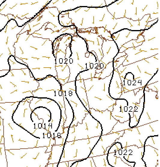
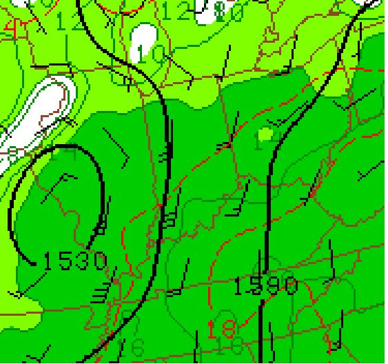
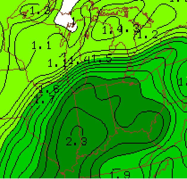
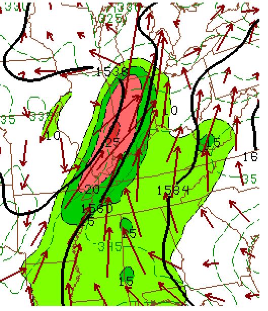
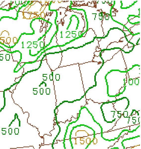
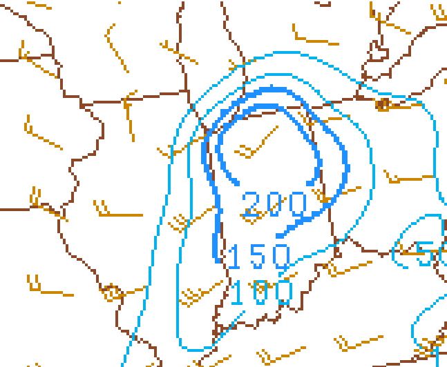
Deepening low pressure was located over SW Illinois. Extremely high, tropical based moisture was in place across the forecast area. Precipitable waters, a measure of the total water content of the atmosphere, were in excess of 2 inches as shown in Figure 4. Figure 5 shows the strong and deep moisture transport straight out of the Gulf coast. Surface Based CAPE (Figure 6) was relatively low over the forecast area in comparison to where the supercell initiated and produced the most tornadoes. Lifted Condensation Levels (LCLs) were extremely low as shown in Figure 7 with near ground cloud bases and the lowest 1 km of the atmosphere was characterized by Storm relative Helicity of over 200. This allowed for persistent mesocyclones and weak tornadic production.
 |
 |
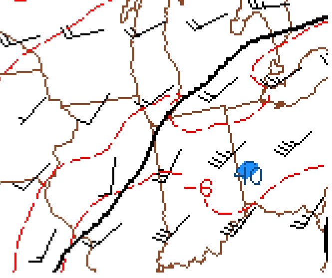 |
| Figure 1: Surface Map | Figure 2: 850 mb Map | Figure 3: 500 mb Map |
 |
 |
 |
| Figure 4: Precipitable Water | Figure 5: 850 mb Moisture Transport | Figure 6: Surface Based CAPE |
 |
 |
|
| Figure 7: Lifted Condensation Levels | Figure 8: 0-1 km Storm Relative Helicity | Figure 9: Rotational Track |
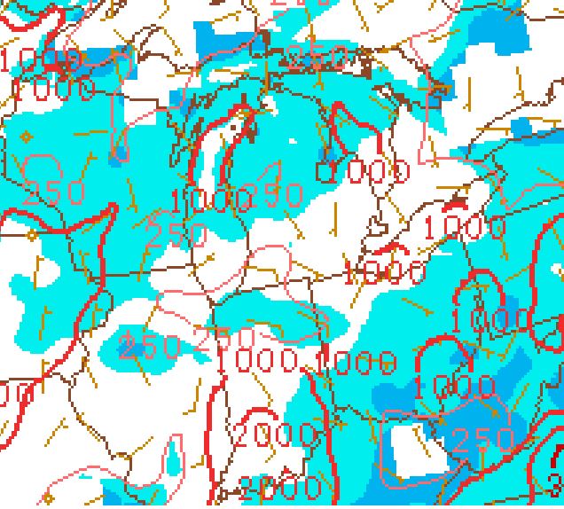
SPC and WPC Products
 |
 |
 |
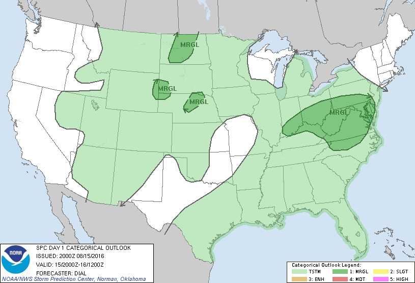
| SPC Day 1 Outlook at 4 pm EDT | Mesoscale Precip Discussion #1 | Mesoscale Precip Discussion #2 |
 |
Media use of NWS Web News Stories is encouraged! Please acknowledge the NWS as the source of any news information accessed from this site. |
|

