Overview
Severe storms developed across portions of the Northern Indiana (IWX) forecast area early on the morning of August 12th, 2021. Wind gusts of 55 to 60 mph were measured, but pockets of higher end severe wind gusts ranging from 65 to 75 mph were estimated based off of the damage reports and photos. Wind damage reports came in from several locations in Northern Indiana and southern Lower Michigan starting from around 5 am EDT and ending around 7:30 am EDT. Counties especially hard hit were Elkhart, Marshall, and Kosciusko Counties in Indiana; in addition to St. Joseph/Branch/Hillsdale Counties in Michigan. Click the tabs below to view photos, radar imagery, storm reports, rainfall amounts, and environmental data from this event. Thank you to those who submitted photos and reports of wind speeds and damage, in addition to storm photos and rainfall reports.
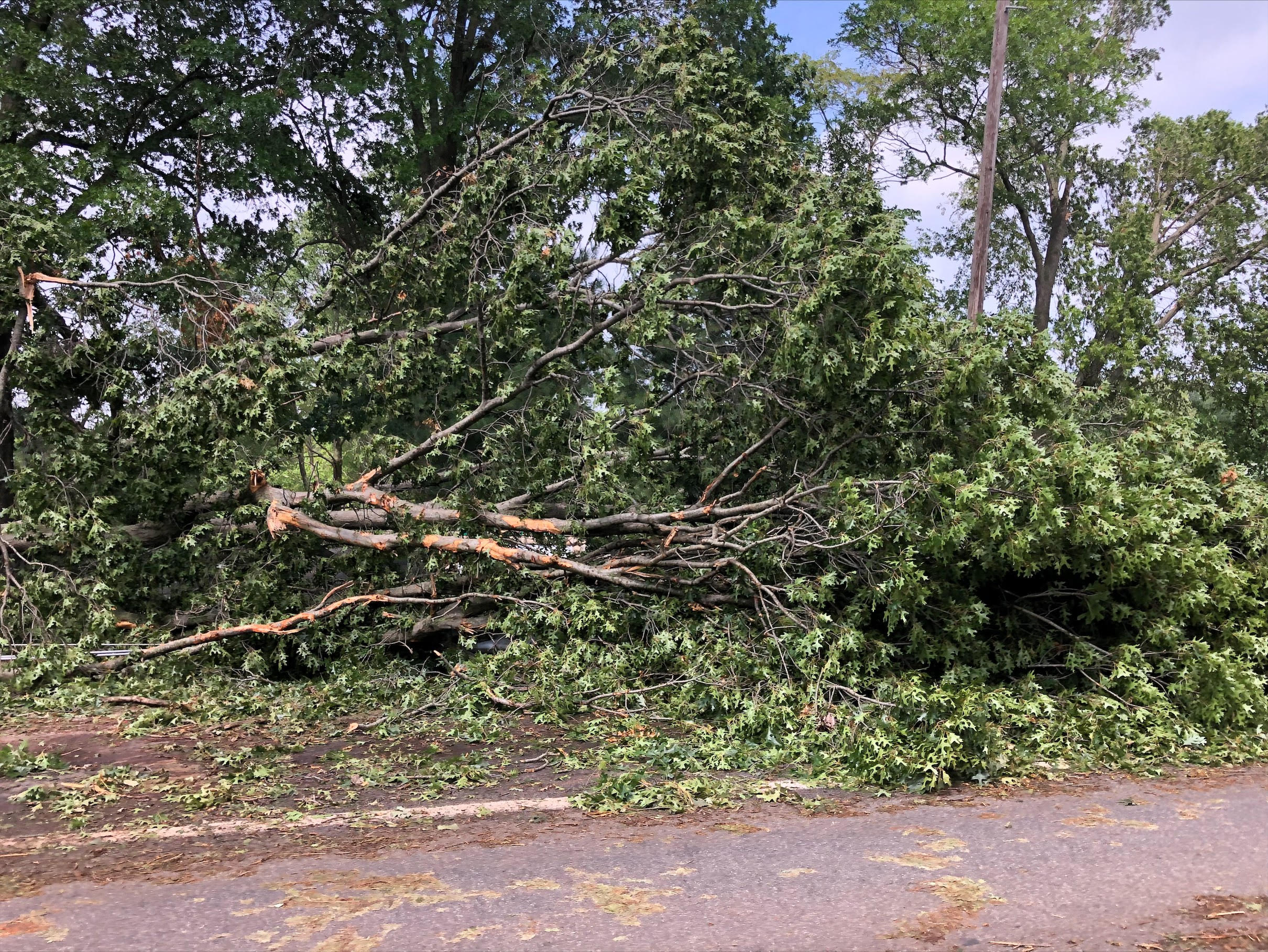
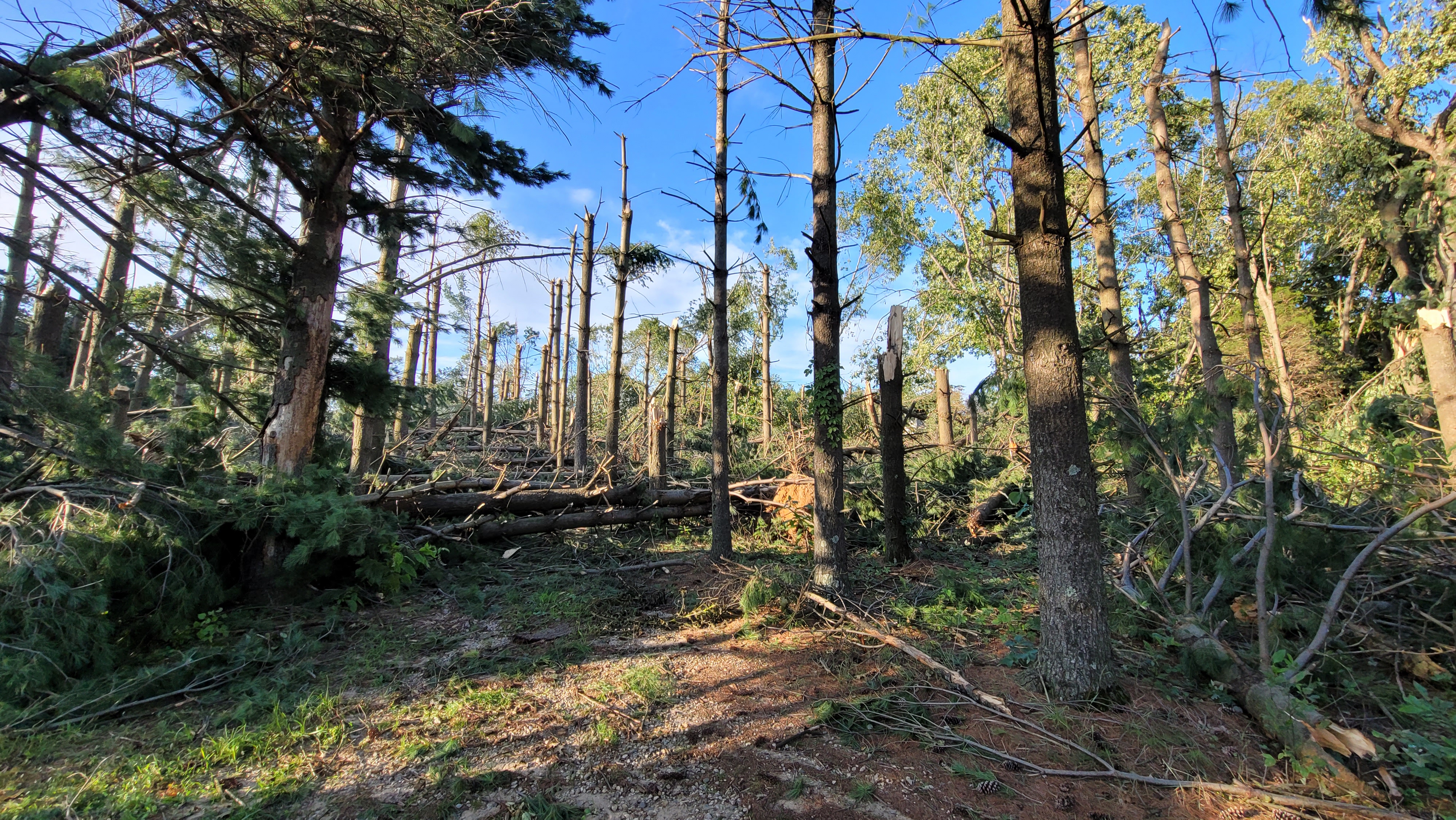
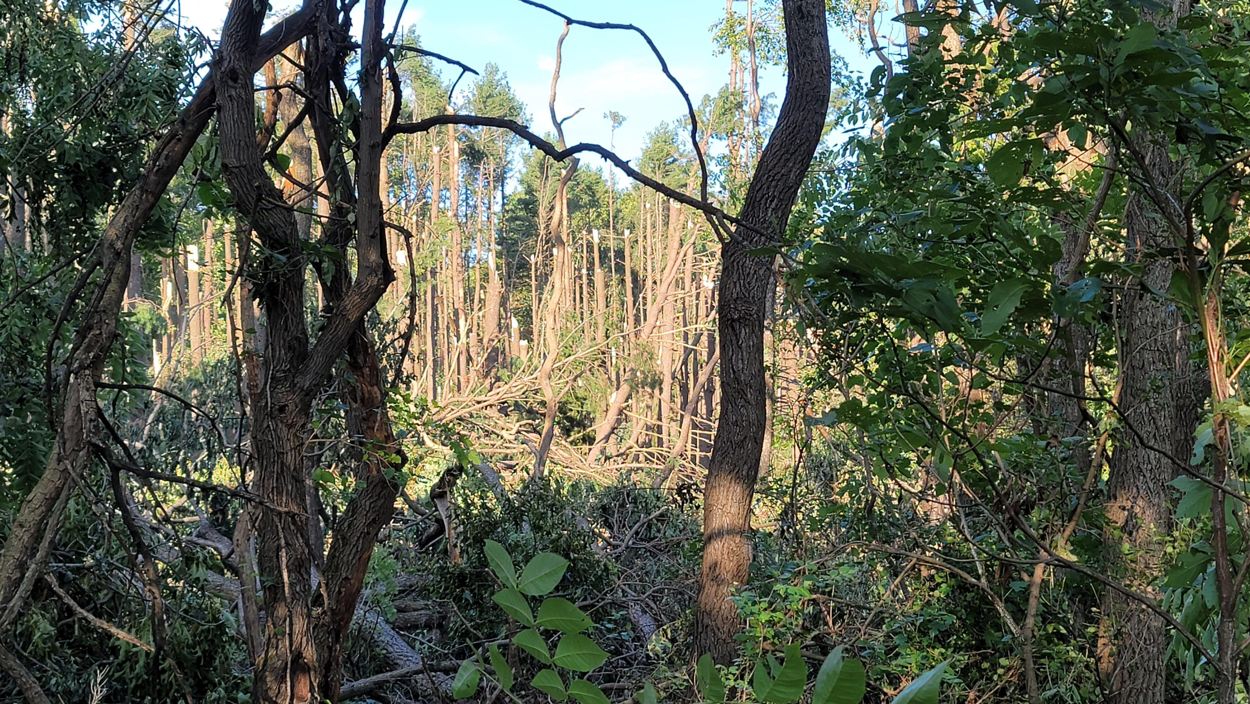
Downburst
|
Downburst - Sturgis, MI
|
||||||||||||
|
||||||||||||
Measured Wind Gusts
Below are the wind gusts that were actually measured by weather stations during the August 12th, 2021 damaging wind event. Isolated pockets of much higher wind gusts ranging from 65 to 75 mph were estimated by the damage produced from the storms (see storm report and photos tab).
NOUS43 KIWX 130512
PNSIWX
INZ003>009-012>018-020-022>027-032>034-MIZ077>081-OHZ001-002-004-005-015-
016-024-025-131712-

PUBLIC INFORMATION STATEMENT
NATIONAL WEATHER SERVICE NORTHERN INDIANA
112 AM EDT FRI AUG 13 2021

...HIGHEST MEASURED WIND REPORTS AUGUST 12TH 2021...

LOCATION                     SPEED     TIME/DATE       LAT/LON

...INDIANA...

...ELKHART COUNTY...
GOSHEN                       43 MPH    0523 AM 08/12   41.53N/85.78W
2.6 SW SIMONTON LAKE (INDOT) 41 MPH    0534 AM 08/12   41.72N/86.01W

...FULTON COUNTY...
1 NNW ATHENS                 57 MPH    0644 AM 08/12   41.07N/86.13W
2 NW ROCHESTER               55 MPH    0636 AM 08/12   41.08N/86.22W
4 W ROCHESTER                54 MPH    0630 AM 08/12   41.05N/86.27W

...KOSCIUSKO COUNTY...
2 N NORTH WEBSTER            53 MPH    0722 AM 08/12   41.36N/85.70W
WARSAW MUNICIPAL AP          45 MPH    0655 AM 08/12   41.27N/85.83W
1 S MONOQUET                 45 MPH    0655 AM 08/12   41.27N/85.86W

...STEUBEN COUNTY...
ANGOLA                       52 MPH    0835 AM 08/12   41.63N/85.08W

...WHITE COUNTY...
MONTICELLO - WHITE COUNTY AR 45 MPH    0615 AM 08/12   40.72N/86.77W

...WHITLEY COUNTY...
4.5 S COLUMBIA CITY          40 MPH    0715 AM 08/12   41.09N/85.47W

...MICHIGAN...

...BRANCH COUNTY...
2 WSW COLDWATER              59 MPH    0608 AM 08/12   41.93N/85.05W
1.6 NW BATAVIA (MAWN)        46 MPH    0700 AM 08/12   41.93N/85.11W

...HILLSDALE COUNTY...
3 E HILLSDALE                54 MPH    0630 AM 08/12   41.92N/84.58W
JEROME                       45 MPH    0640 AM 08/12   42.02N/84.46W
HILLSDALE                    41 MPH    0654 AM 08/12   41.92N/84.58W

...ST. JOSEPH COUNTY...
STURGIS KIRSCH               54 MPH    0555 AM 08/12   41.80N/85.43W
1 NW STURGIS                 54 MPH    0555 AM 08/12   41.81N/85.44W

OBSERVATIONS ARE COLLECTED FROM A VARIETY OF SOURCES WITH VARYING
EQUIPMENT AND EXPOSURES. WE THANK ALL VOLUNTEER WEATHER OBSERVERS
FOR THEIR DEDICATION. NOT ALL DATA LISTED ARE CONSIDERED OFFICIAL.

$$
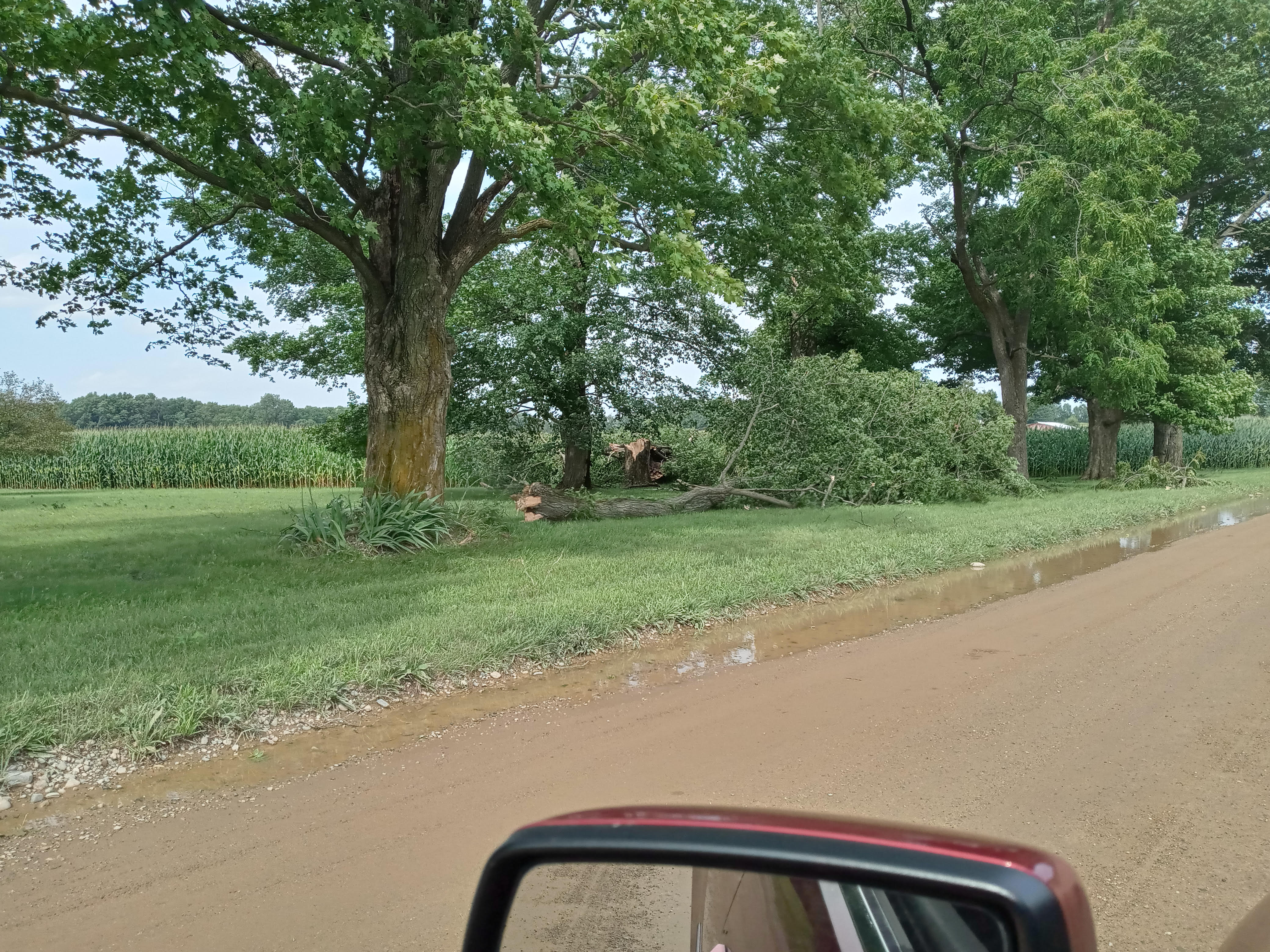
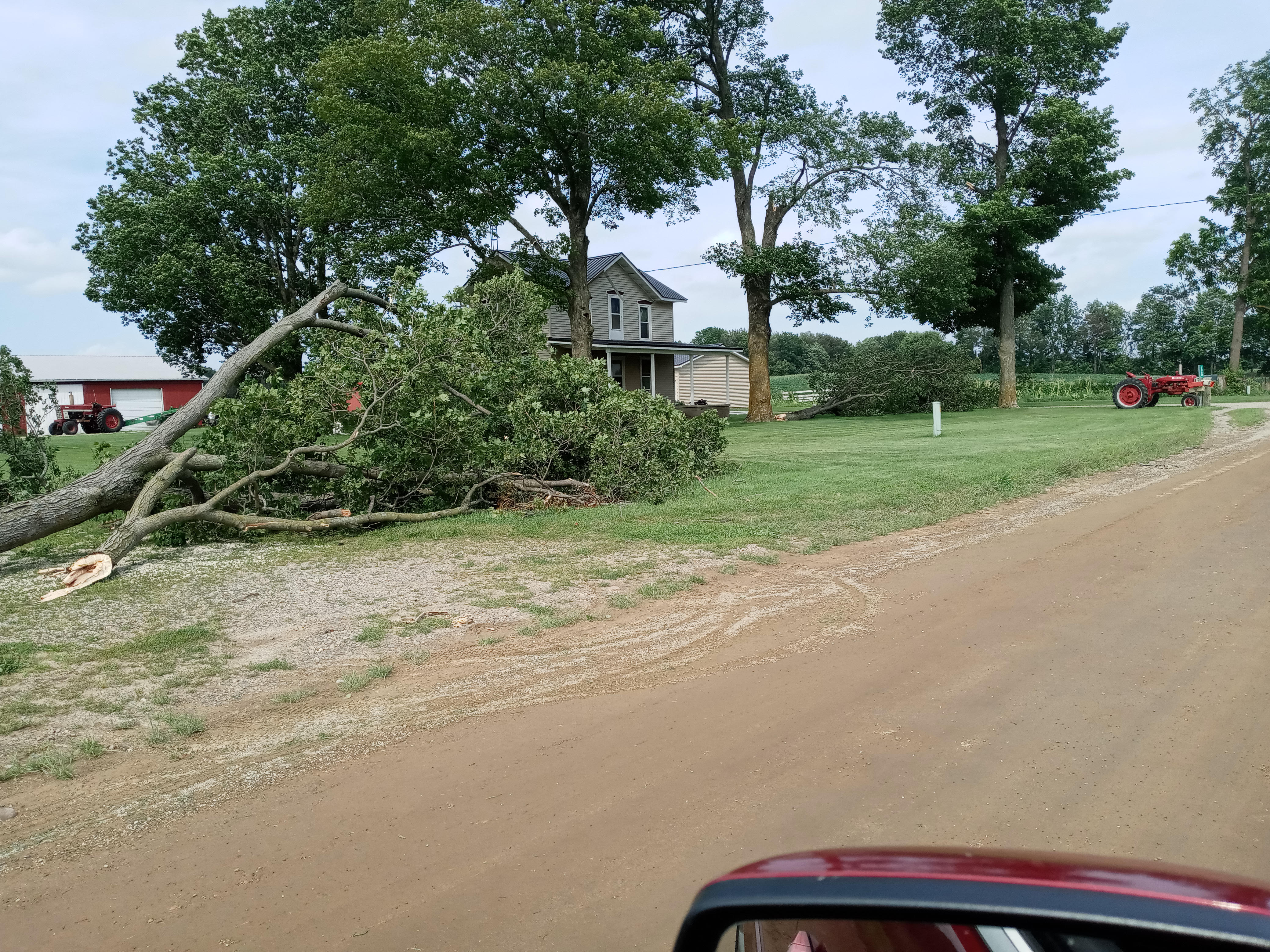
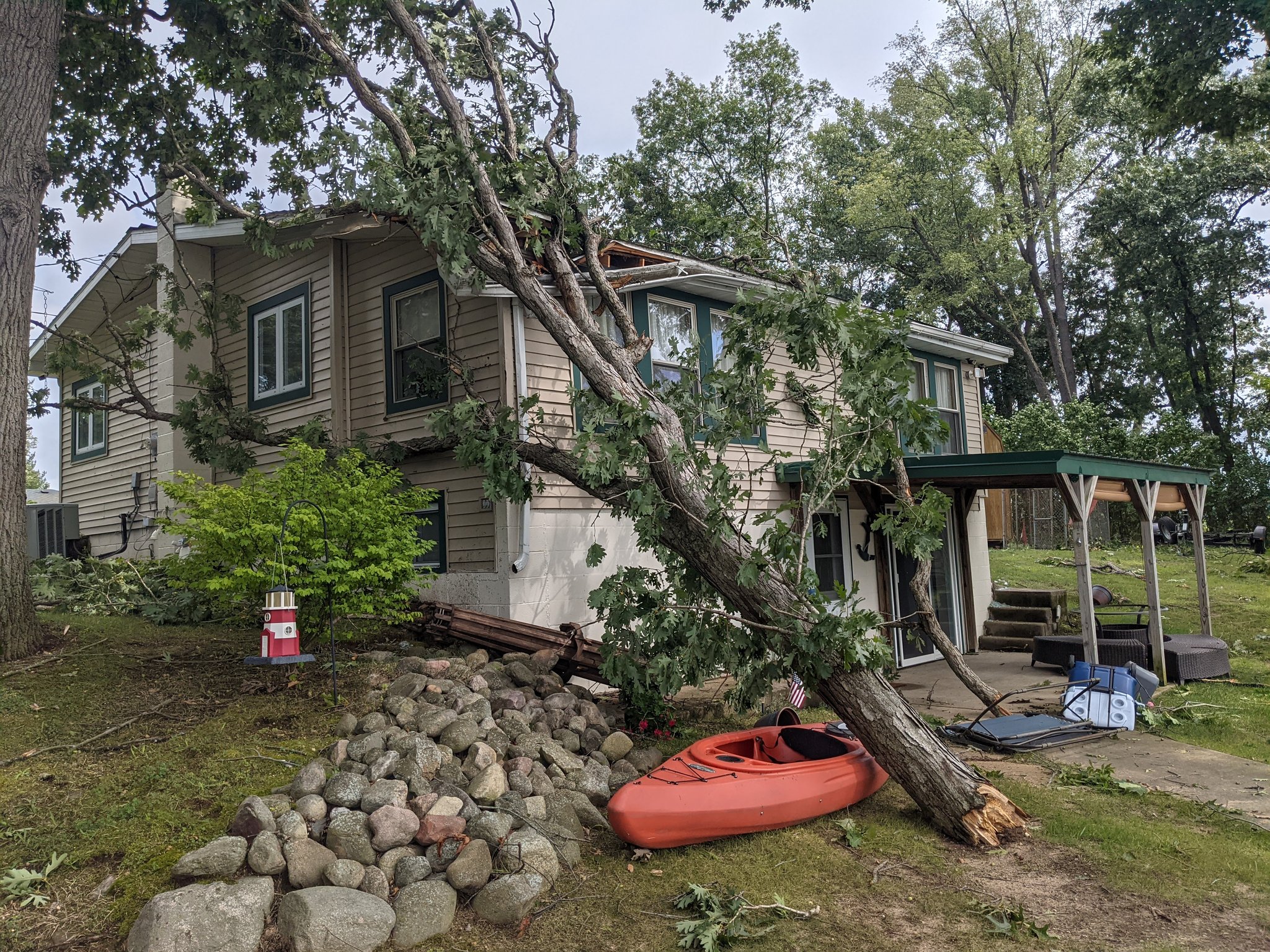
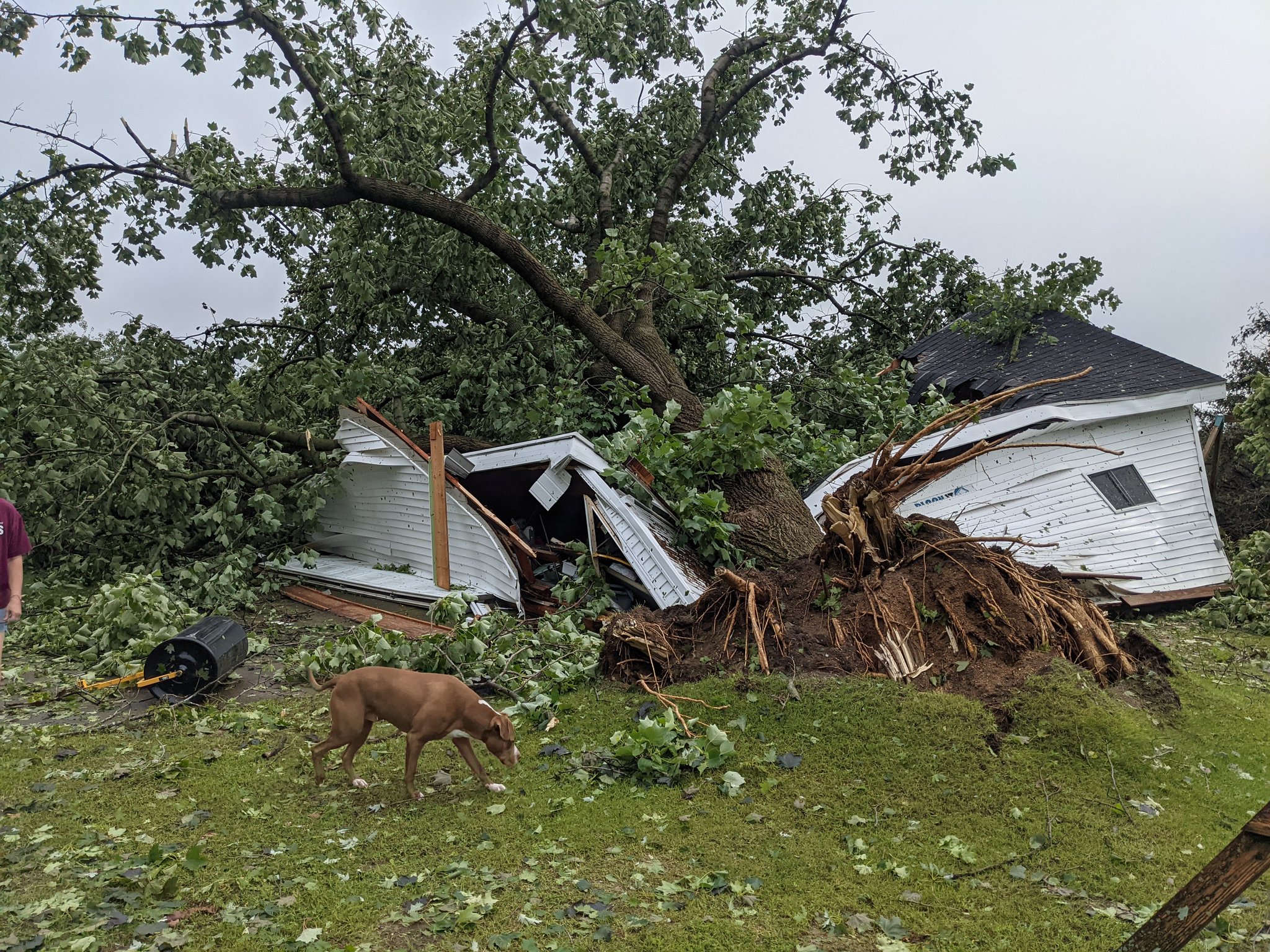
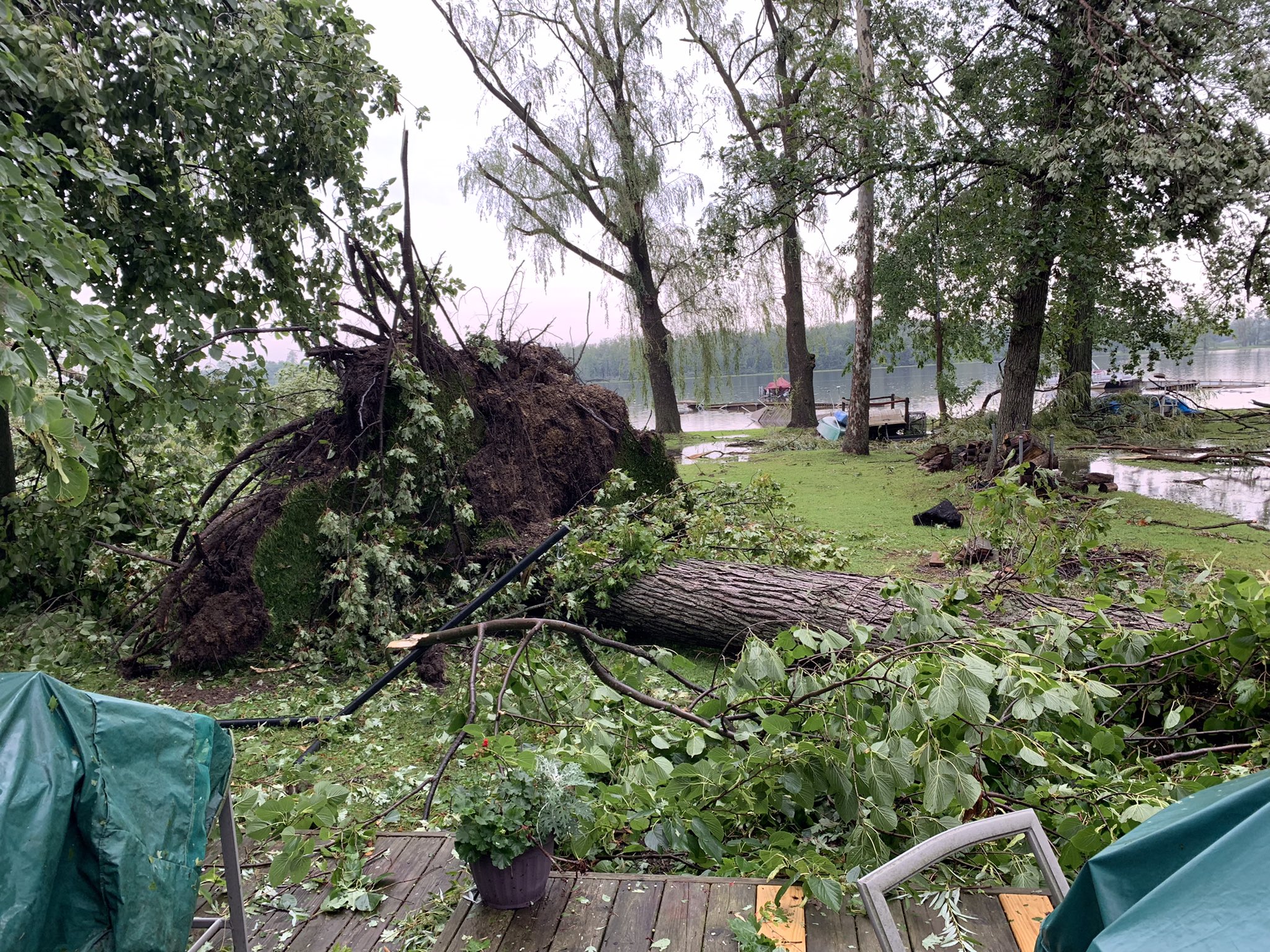
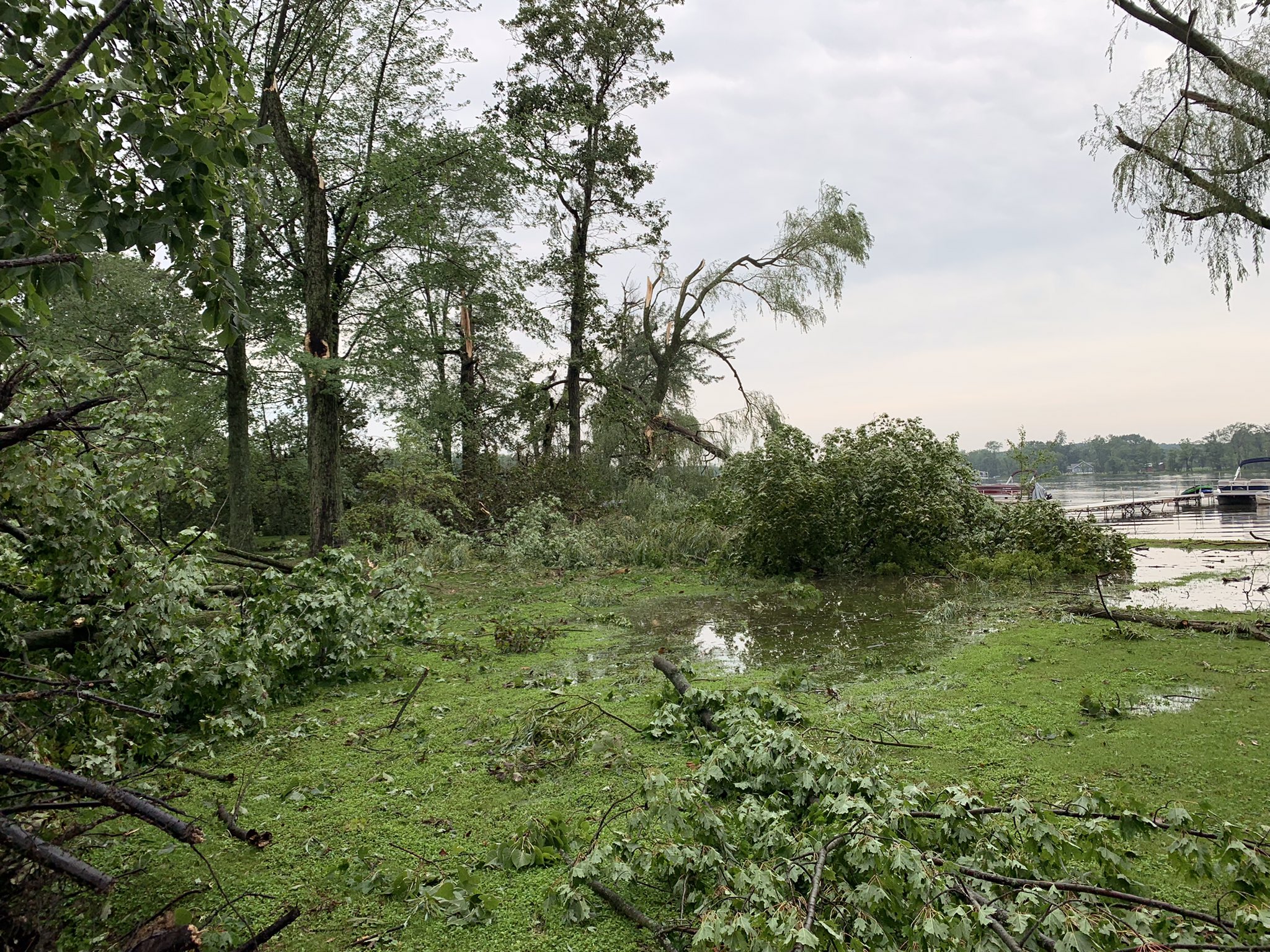
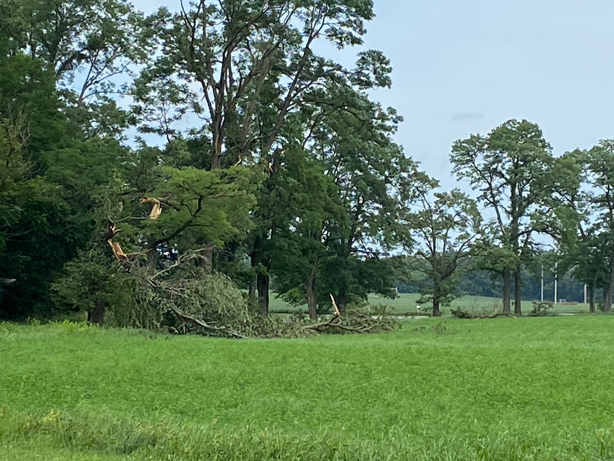
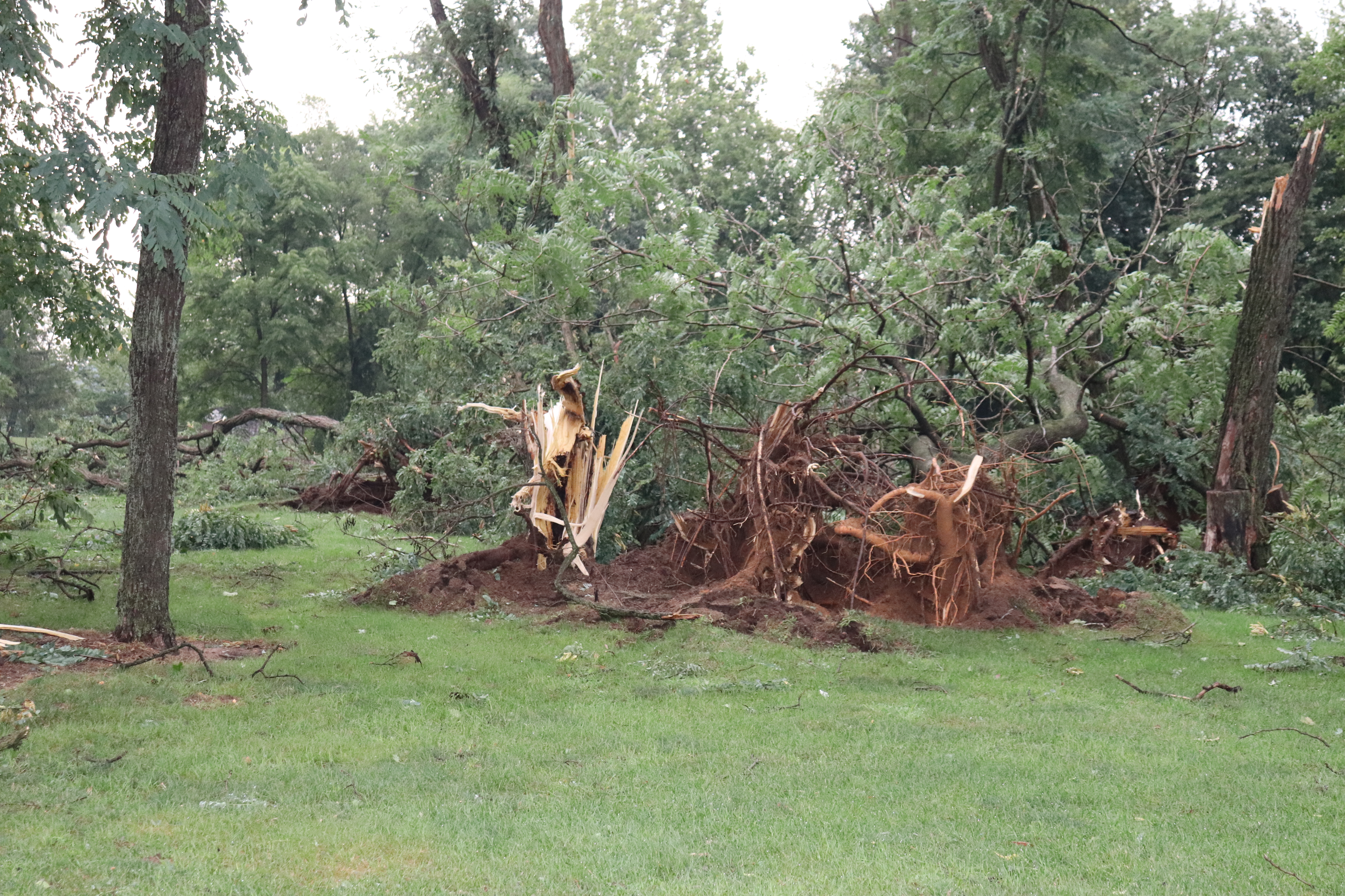
Photos
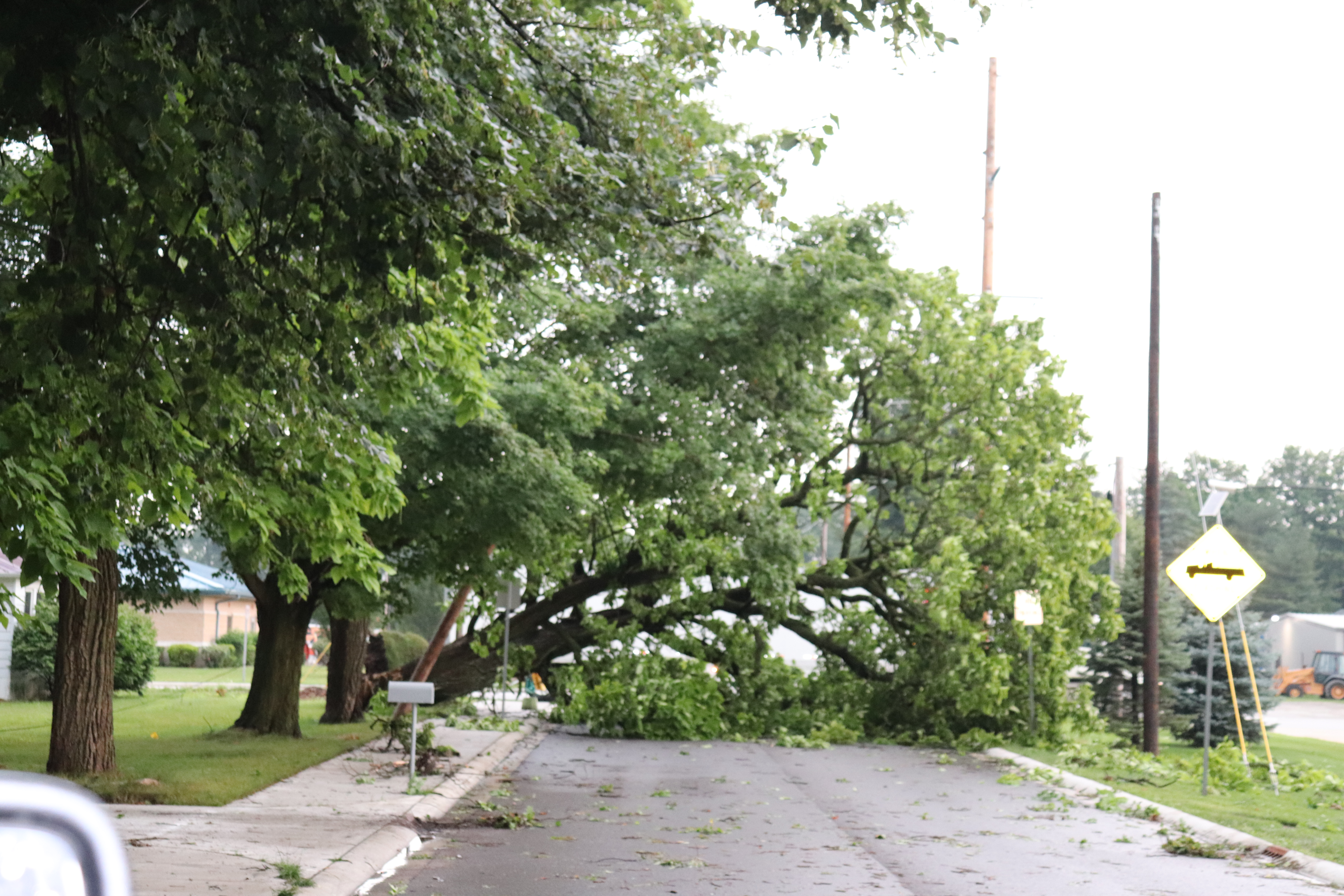
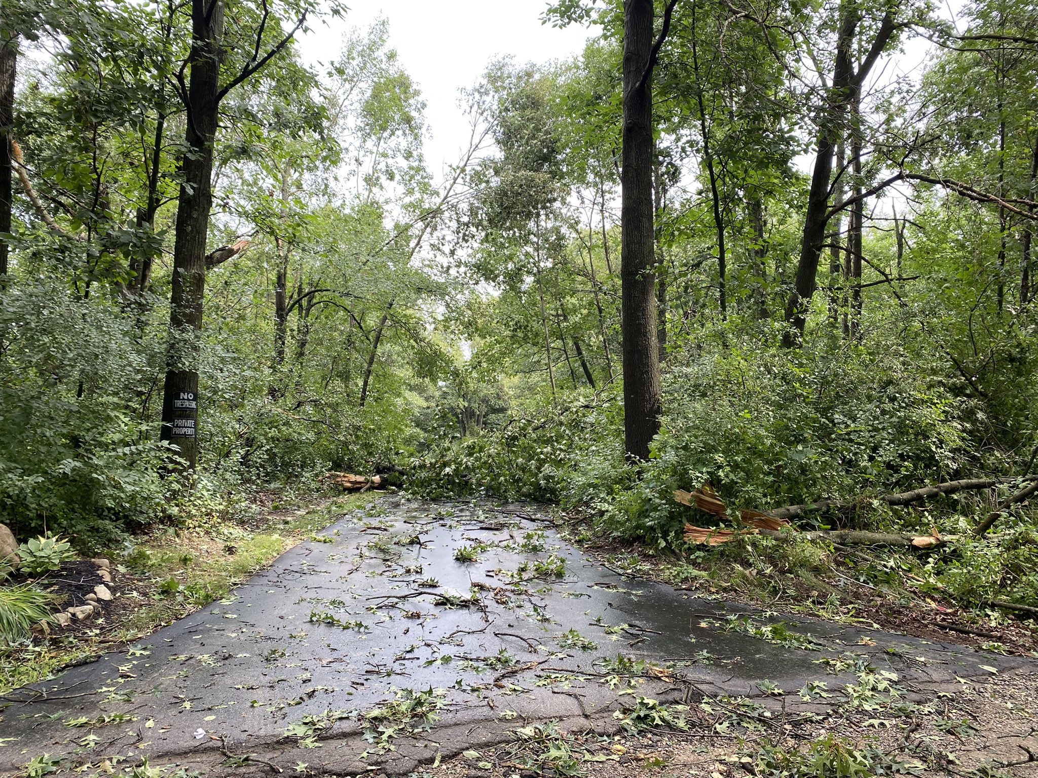
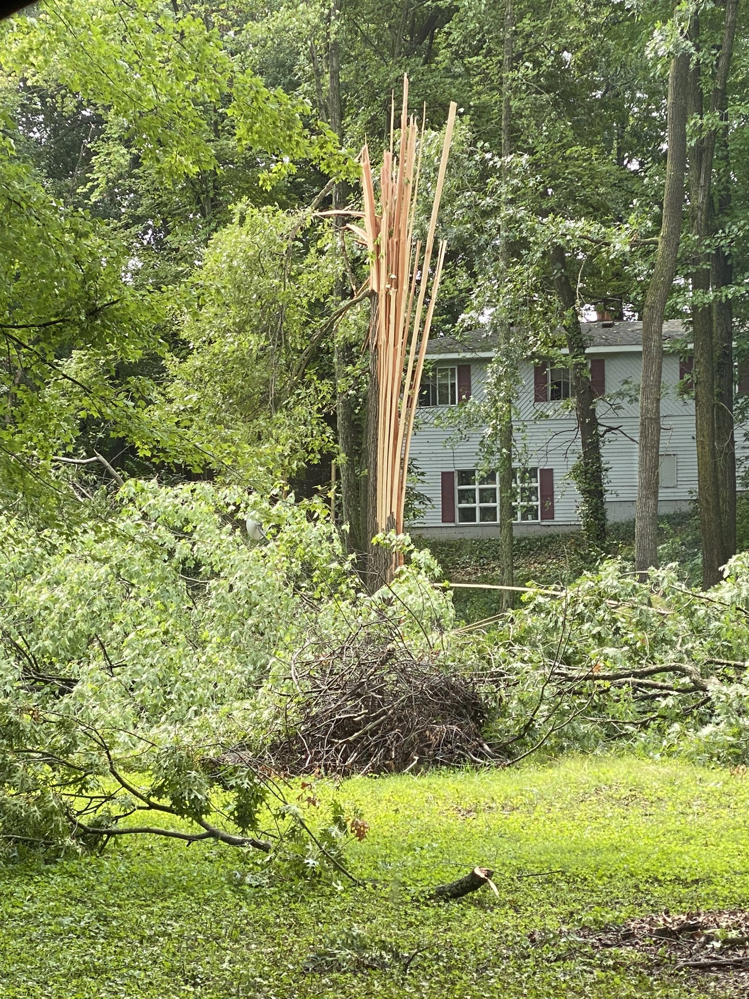
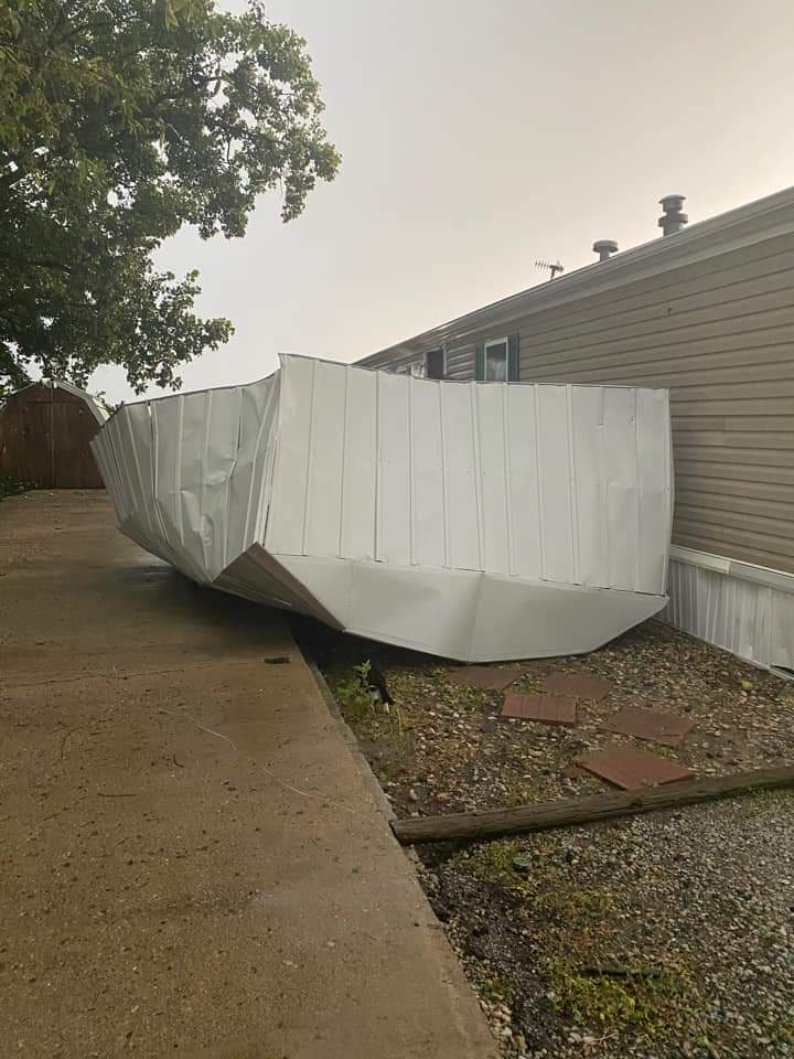
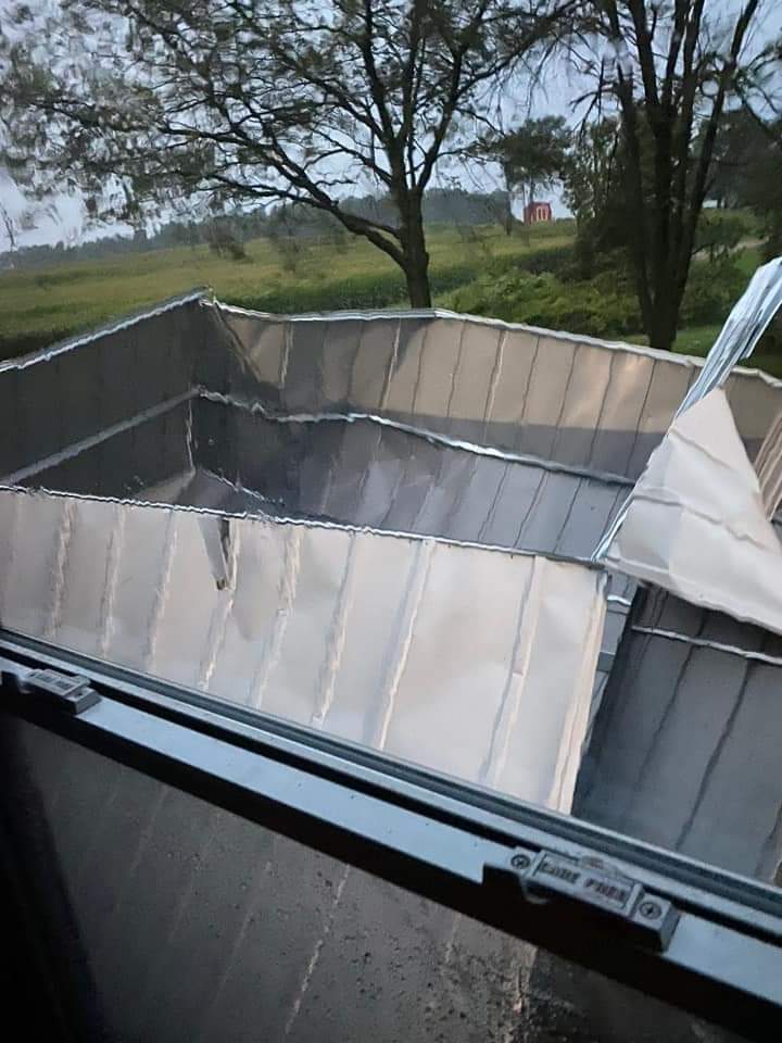
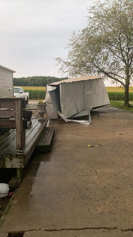
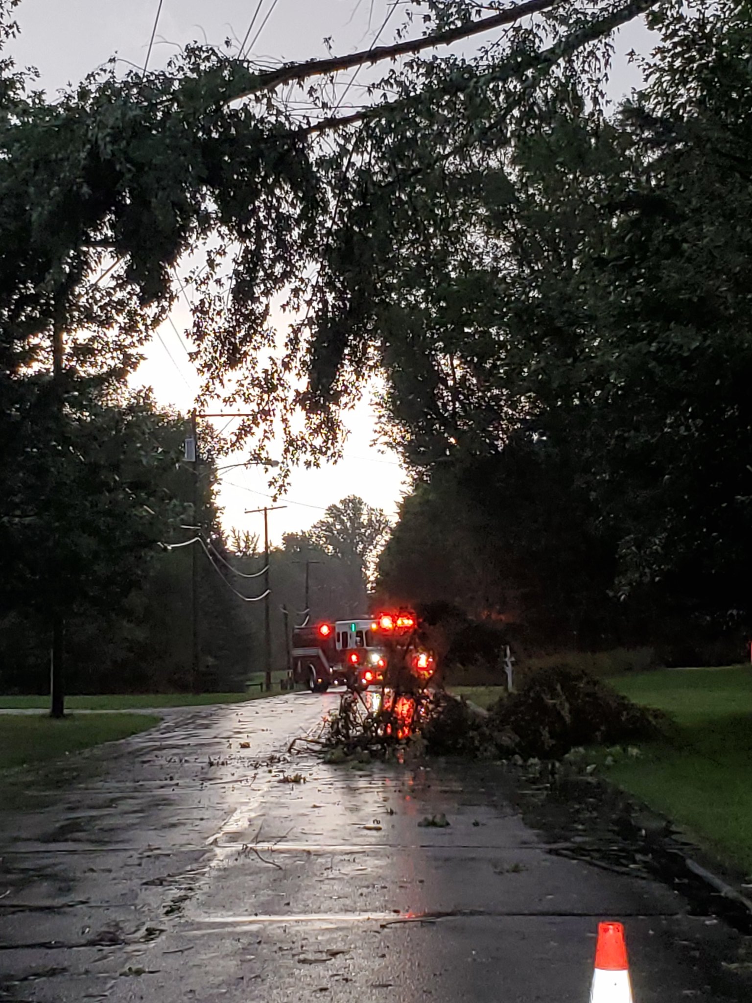
Wind Damage Photos from August 12th, 2021
Photos from the August 12th, 2021 straight-line wind event are below. Thank you to those who submitted them! If you have pictures of damage or storms that you want us to see, send it to our email account (nws.northernindiana@noaa.gov) or post it on our Twitter (@NWSIWX) or Facebook. Remember to use the TEL method when you submit your report, including the Time, Event, & Location. Unfortunately, at the time of the event and through August 13th, our phone system went down and many folks reported only having a busy signal when they tried to call. We apologize for any inconvenience this may have caused.
 |
 |
 |
 |
| Wind Damage in Goshen, IN (Twitter User @GHSWx) |
Wind Damage 1.5 NE of Moscow, MI (Scott Taylor) |
Wind Damage 1.5 NE of Moscow, MI (Scott Taylor) |
Wind Damage in Colon, MI (Tom Talbot) |
 |
 |
 |
 |
| Wind Damage in Findley, MI (Tom Talbot) |
Wind Damage in Sturgis, MI (Jessa Vanites) |
Wind Damage in Sturgis, MI (Jessa Vanites) |
Wind Damage in Bristol, IN (Jen Yoder) |
 |
 |
 |
 |
| Wind Damage in Bristol, IN (Mike Yoder) |
Wind Damage in Bristol, IN (Mike Yoder) |
Damage in Hillsdale/Jonesville, MI (Rene Philips) |
Damage in Hillsdale/Jonesville, MI (Rene Philips) |
 |
 |
 |
 |
| Wind Damage in Mentone, IN (Nick Deraneck) |
Wind Damage in Mentone, IN (Nick Deraneck) |
Wind Damage in Mentone, IN (Nick Deraneck) |
Wind Damage in Winona Lake, IN (Roger Grossman) |
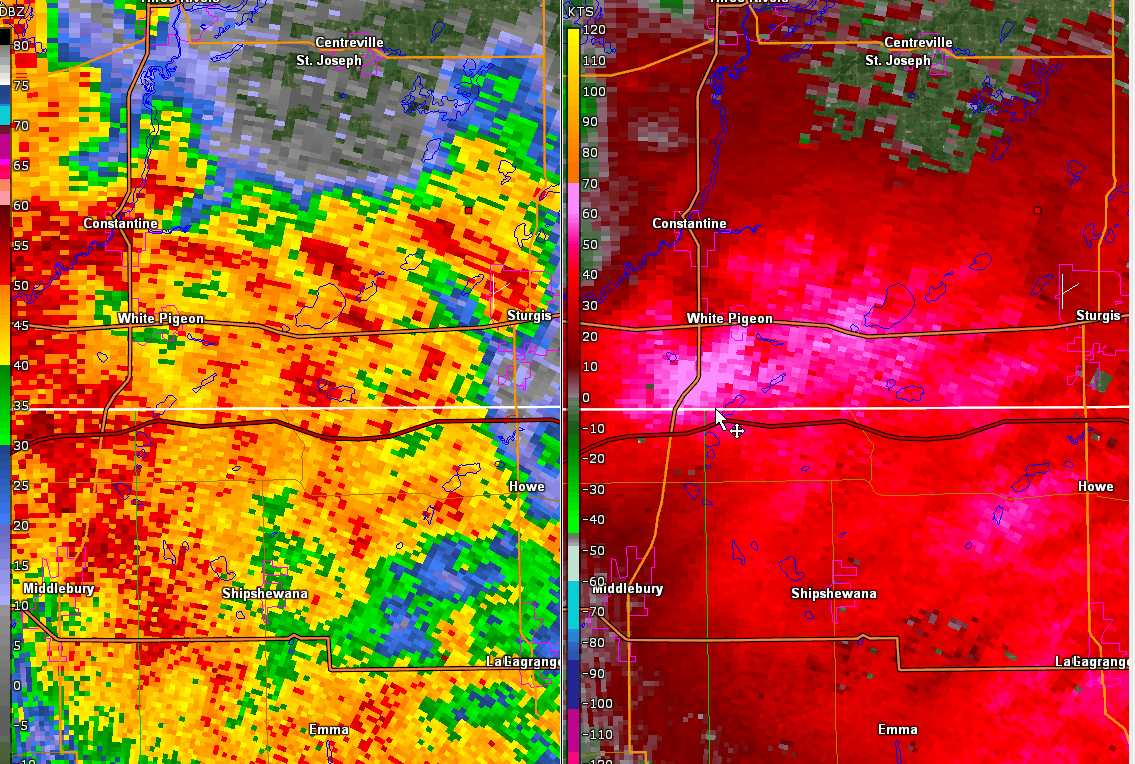
Radar
Radar Loops from August 12th, 2021
A radar velocity and reflectivity loop from KIWX (images created with GR2Analyst) of the storms moving through portions of the Northern Indiana Forecast area (map). Click the square on each loop to expand it. The left loop was from 5 am-6:53 am EDT. The loop on the right was from 5:40 am-7:24 am EDT August 12th, 2021. Each loop focuses on a different area of storms, so the times overlap slightly.
Storm Reports
PUBLIC INFORMATION STATEMENT
NATIONAL WEATHER SERVICE NORTHERN INDIANA
415 PM EDT MON AUG 16 2021 /315 PM CDT MON AUG 16 2021/

...PUBLIC INFORMATION STATEMENT...

...FINAL SUMMARY OF STORM DAMAGE OCCURRING DURING EARLY MORNING
HOURS OF AUGUST 12, 2021...

THUNDERSTORMS BROUGHT YET ANOTHER ROUND OF DAMAGING TO NORTHERN
INDIANA AND FAR SOUTHERN LOWER MICHIGAN DURING THE EARLY MORNING
HOURS OF AUGUST 12, 2021. AFTER EXTENSIVE REVIEW OF DATA FROM
EMERGENCY MANAGEMENT OFFICIALS AS WELL AS SPOTTERS AND THE PUBLIC
WHO HAVE SHARED THEIR DAMAGE DETAILS, IT HAS BEEN DETERMINED THAT
ALL DAMAGE APPEARS TO BE RELATED TO STRAIGHT LINE WINDS OR
DOWNBURSTS. THE WINDS CAUSED TREE, TREE LIMB, POWER LINE AND POLE
DAMAGE WITH REPORTS OF STRUCTURE DAMAGE GENERALLY COMING FROM
FALLING TREES OR TREE LIMBS. WHILE AREAS OF DAMAGE WERE REPORTED IN
PORTIONS OF KOSCIUSKO, MARSHALL AND ELKHART COUNTIES IN INDIANA, THE
GREATEST DAMAGE HAS BEEN REPORTED IN PORTIONS OF ST. JOSEPH, BRANCH
AND HILLSDALE COUNTIES IN MICHIGAN. WINDS SPEEDS FOR MUCH OF THE
DAMAGE ARE ESTIMATED FROM 60 TO AS HIGH AS 75 MPH. HOWEVER, A FEW
INSTANCES OF MORE INTENSE DOWNBURST DAMAGE WERE OBSERVED. BELOW ARE
ADDITIONAL DETAILS ON AREAS OF MORE SIGNIFICANT DAMAGE OR REPORTS OF
WEATHER RELATED INJURIES.

THIS IS THE FINAL UPDATE TO THE AUGUST 12, 2021 STORM DAMAGE
SUMMARY.

.ELKHART COUNTY, INDIANA

THREE PEOPLE WERE INJURED ON COUNTY ROAD 1, NORTH OF WYNDTREE
BOULEVARD WHEN A VEHICLE STRUCK A TREE IN THE ROADWAY. THE DRIVER
AND TWO PASSENGERS WERE TAKEN TO LOCAL HOSPITALS WITH UNKNOWN
INJURIES.

IN THE TOWN OF BRISTOL, SEVERAL TREES WERE UPROOTED IN A
NEIGHBORHOOD NEAR BRISTOL ELEMENTARY SCHOOL IN ADDITION TO CONGDON
PARK ALONG THE ELKHART RIVER. TWO HOMES WERE DAMAGED NEAR THE
ELEMENTARY SCHOOL WHEN LARGE TREES UPROOTED DURING THE STORM FELL
ONTO THE ROOFS. DUE SOUTH OF THE SCHOOL, A BUSINESS HAD PART OF
THEIR METAL ROOF BLOWN OFF. ADDITIONAL CONSIDERABLE TREE AND POWER
LINE DAMAGE WAS NOTED AT THE INTERSECTION OF ST. JOESPH AND ELM
STREET, WHERE AN UPROOTED TREE OF AN ESTIMATED 5-6 FT IN DIAMETER
FELL ON POWER LINES. NUMEROUS BRANCHES AND TREE LIMBS WERE ALSO DOWN
ONTO POWER LINES THROUGHOUT THE CITY OF BRISTOL, PRIMARILY
CONCENTRATED ON THE NORTHWEST SIDE OF TOWN. MAXIMUM ESTIMATED WIND
SPEEDS OF UP TO 75 MPH APPEAR LIKELY IN SPOTS.

.ST JOSEPH COUNTY, MICHIGAN

SIGNIFICANT DAMAGE APPEARS TO HAVE OCCURRED IN EASTERN ST. JOSEPH
COUNTY IN A SWATH FROM WHITE PIGEON AND CONSTANTINE NORTHEAST TO
CENTREVILLE, STURGIS AND COLON. DETAILS FROM THE CITY OF STURGIS AS
WELL AS ST. JOSEPH COUNTY EMERGENCY MANAGEMENT INDICATES THAT
WIDESPREAD TREE DAMAGE BETWEEN STURGIS AND CENTREVILLE HAS CAUSED
RESULTING IN DAMAGE TO OVER 15 MILES OF POWER LINES AND OVER 40
POWER POLES BEING SNAPPED. GROUND AND AERIAL PICTURES OF THE DAMAGE
CLEARLY INDICATE STRONG DOWNBURST WINDS SNAPPING OR LEVELING AREAS
OF TREES, NUMBERING WELL OVER 100 IN SPOTS. WIND SPEEDS IN THESE
AREAS ARE ESTIMATED BETWEEN 85 TO OVER 90 MPH.

.BRANCH COUNTY, MICHIGAN

BRANCH COUNTY EMERGENCY MANAGEMENT, WITH THE ASSISTANCE OF THE
MICHIGAN STATE POLICE, PERFORMED A AERIAL ASSESSMENT OF DAMAGE FROM
COLDWATER, SOUTHEAST TO MARBLE LAKE AND THEN NORTH TO QUINCY. SMALL
AREAS OF TREE AND CROP DAMAGE WERE NOTED BETWEEN COLDWATER AND
MARBLE LAKE, CONSISTENT WITH WIND SPEEDS OF 60 TO AT MOST 70 MPH.
THE AMOUNT OF TREE DAMAGE DID INCREASE SOMEWHAT ON THE NORTHEAST
SIDE OF MARBLE LAKE, WITH SEVERAL FALLING ONTO HOMES. SOME FIELDS IN
THE AREA SHOWN SOME FLATTENED CORN. WIND SPEEDS IN THE AREA OF
MARBLE LAKE WERE LIKELY CLOSER TO 70 MPH.

.HILLSDALE COUNTY, MICHIGAN

THE SOUTHWEST FACING PORTION OF THE ROOF OF THE JONESVILLE CITY
HALL WAS LIFTED UP AND OVER THE BUILDING, LANDING ROUGHLY 80 FEET
INTO A NEARBY PARK. THE CITY'S WEATHER SIREN, LOCATED AT THE TOP
OF CITY HALL, WAS ALSO BLOWN OFF. NO OTHER STRUCTURE DAMAGE, NOR
SIGNIFICANT TREE DAMAGE, WAS NOTED IN THE CITY. A COMBINATION OF
WHAT WAS REPORTED AS POOR CONDITION TO THE ROOF, HIGHER ELEVATION
OF THE TOWN AND THE BUILDING, AS WELL AS WIND FLOW UNDER THE LIP
OF THE ROOF, ALL LED TO THE ROOF FAILURE. WIND SPEEDS ARE
ESTIMATED BETWEEN 60 AND 70 MPH.

WIDESPREAD DAMAGE WAS REPORTED ACROSS MAINLY WESTERN AND NORTHERN
PORTIONS OF THE COUNTY WITH DOWNED TREES BLOCKING ROADWAYS, LANDING
ON HOMES OR VEHICLES. MANY POWER LINES WERE REPORTED DOWN AS WELL,
MAINLY FROM FALLING TREES OR TREE LIMBS. WIND SPEEDS ARE ESTIMATED
FROM 60 MPH TO 70 MPH.

THE AERIAL SURVEY FROM BRANCH COUNTY DID EXTEND OVER INTO HILLSDALE
COUNTY IN AND NORTHWEST OF JONESVILLE. IN ADDITION TO FLYING OVER
THE CITY OF JONESVILLE, AREAS TO THE NORTHWEST OF THE CITY WERE
LOOKED AT. A FEW CORN FIELDS SHOWED EXTENSIVE DAMAGE WITH THE CORN
FLATTENED IN NEARLY ALL OF ONE FIELD AND NEARLY THREE QUARTERS OF
ANOTHER FIELD NEARBY. OF NOTE IS TREES SURROUNDING THESE FIELDS
SHOWED NO DAMAGE AND IN ONE FIELD THE CROPS WERE ACTUALLY PARTIALLY
SHELTERED FROM THE STRONG WINDS.

$$

FISHER
PRELIMINARY LOCAL STORM REPORT...SUMMARY
NATIONAL WEATHER SERVICE NORTHERN INDIANA
152 AM EDT FRI AUG 13 2021

..TIME...   ...EVENT...      ...CITY LOCATION...     ...LAT.LON...
..DATE...   ....MAG....      ..COUNTY LOCATION..ST.. ...SOURCE....
            ..REMARKS..

0445 AM     TSTM WND DMG     2 E WALKERTON           41.47N 86.44W
08/12/2021                   MARSHALL           IN   EMERGENCY MNGR

            ROAD CLOSED DUE TO TREES DOWN.

0450 AM     TSTM WND DMG     2 NE TWIN LAKES         41.32N 86.34W
08/12/2021                   MARSHALL           IN   EMERGENCY MNGR

            ROAD CLOSED DUE TO TREES DOWN.

0450 AM     TSTM WND DMG     2 N DONALDSON           41.39N 86.44W
08/12/2021                   MARSHALL           IN   EMERGENCY MNGR

            ROAD CLOSED DUE TO TREES DOWN.

0455 AM     TSTM WND DMG     1 SSE LINKVILLE         41.40N 86.27W
08/12/2021                   MARSHALL           IN   EMERGENCY MNGR

            ROAD CLOSED DUE TO DOWNED TREES.

0515 AM     TSTM WND DMG     1 NNE WATERFORD MILLS   41.56N 85.82W
08/12/2021                   ELKHART            IN   TRAINED SPOTTER

            HEALTHY TREE SNAPPED AT THE BASE AND DOWN ON
            A FENCE. PHOTO VIA EMAIL.

0515 AM     TSTM WND DMG     GOSHEN                  41.58N 85.83W
08/12/2021                   ELKHART            IN   NWS EMPLOYEE

            SEVERAL LARGE TREE BRANCHES DOWN ACROSS THE
            SOUTH SIDE OF CITY. POWER OUTAGES.

0530 AM     TSTM WND DMG     BRISTOL                 41.72N 85.82W
08/12/2021                   ELKHART            IN   BROADCAST MEDIA

            HEALTHY PINE TREE SPLIT NEAR THE BASE, TREE
            LEANING ON POWER LINE. PHOTO VIA EMAIL.

0532 AM     TSTM WND DMG     1 E BRISTOL             41.72N 85.79W
08/12/2021                   ELKHART            IN   BROADCAST MEDIA

            HEALTHY PINE TREE SNAPPED AND DOWN ON A
            MOBILE HOME. UNKNOWN IF THERE ARE INJURIES.

0536 AM     TSTM WND DMG     CONSTANTINE             41.84N 85.67W
08/12/2021                   ST. JOSEPH         MI   PUBLIC

            DELAYED REPORT. ROTTED TREE SNAPPED IN HALF.

0539 AM     TSTM WND DMG     WHITE PIGEON            41.80N 85.64W
08/12/2021                   ST. JOSEPH         MI   PUBLIC

            TREES DOWN IN THE TOWN OF WHITE PIGEON.

0546 AM     TSTM WND DMG     3 N STURGIS             41.84N 85.42W
08/12/2021                   ST. JOSEPH         MI   PUBLIC

            DELAYED REPORT. SEVERAL LARGE 200 YEAR OLD
            OAK TREES UPROOTED OR SNAPPED, APPROXIMATELY
            1-3 FT IN DIAMETER. NUMEROUS 1-2 FT DIAMETER
            LIMBS DOWNED. TREES APPEAR HEALTHY. WATER
            FROM THE LAKE MOVING INLAND ONTO THE
            BACKYARD OF THE PROPERTY.

0546 AM     TSTM WND DMG     STURGIS                 41.80N 85.42W
08/12/2021                   ST. JOSEPH         MI   PUBLIC

            TREES DOWN AND POWER OUTAGES IN STURGIS.

0553 AM     TSTM WND DMG     2 E MENDON              42.01N 85.41W
08/12/2021                   ST. JOSEPH         MI   TRAINED SPOTTER

            NUMEROUS TREES DOWN OR DAMAGED ON A DRIVE
            FROM M60 AT THE ST. JOSEPH CO-BRANCH CO
            LINE, WEST TO M66, AND THEN SOUTH ON M66 TO
            STURGIS. LSR IS AT THE INTERSECTION OF M60
            AND M66.

0557 AM     TSTM WND DMG     COLON                   41.96N 85.32W
08/12/2021                   ST. JOSEPH         MI   BROADCAST MEDIA

            DELAYED REPORT. 2 FT DIAMETER HEALTHY TREE
            SNAPPED IN HALF. TOP HALF WAS THROWN INTO A
            HOUSE, CAUSING ROOF AND GUTTER DAMAGE.

0557 AM     TSTM WND DMG     FINDLEY                 41.89N 85.37W
08/12/2021                   ST. JOSEPH         MI   BROADCAST MEDIA

            DELAYED REPORT. HEALTHY 1 TO 3 FT DIAMETER
            TREE UPROOTED AND DOWNED ON A GARAGE.
            NEARBY, A TREE WITH PARTIAL ROTTING WAS
            SNAPPED AT THE BASE AND THE TOP LIMBS DID
            DAMAGE TO A HOUSE. SEVERAL SMALLER 3-6 INCH
            LIMBS DOWNED AROUND THE PROPERTY. POWERLINES
            BENT OR DOWNED AS WELL.

0604 AM     TSTM WND DMG     1 NNW COLDWATER         41.96N 85.01W
08/12/2021                   BRANCH             MI   PUBLIC

            TREES DOWN ON UNION CITY ROAD AND STATE
            ROAD.

0605 AM     TSTM WND GST     1 SSW COLDWATER LAKE    41.81N 84.99W
08/12/2021  M37 MPH          BRANCH             MI   PUBLIC

            DELAYED REPORT. MULTIPLE 3- TO 4-INCH
            DIAMETER BRANCHES DOWN.

0607 AM     TSTM WND DMG     WINAMAC                 41.05N 86.60W
08/12/2021                   PULASKI            IN   TRAINED SPOTTER

            REPORT FROM MPING: 3-INCH TREE LIMBS BROKEN;
            POWER POLES BROKEN. TIME ESTIMATED FROM
            RADAR.

0607 AM     TSTM WND DMG     WINAMAC                 41.05N 86.60W
08/12/2021                   PULASKI            IN   BROADCAST MEDIA

            CORRECTS PREVIOUS TSTM WND DMG REPORT FROM
            WINAMAC. TREES DOWN ON 12TH AND MARKET
            STREET IN WINAMAC.

0607 AM     TSTM WND DMG     1 NNE MATTESON LAKE     41.94N 85.20W
08/12/2021                   BRANCH             MI   PUBLIC

            REPORT FROM MPING: TREES UPROOTED OR
            SNAPPED; ROOF BLOWN OFF.

0610 AM     TSTM WND DMG     COLDWATER               41.94N 85.00W
08/12/2021                   BRANCH             MI   PUBLIC

            DELAYED. 1 TO 2 FT DIAMETER TREE AND SEVERAL
            LIMBS DOWNED ON A HOUSE, CAUSING GUTTER AND
            SIDING DAMAGE.

0611 AM     TSTM WND DMG     WINAMAC                 41.05N 86.60W
08/12/2021                   PULASKI            IN   BROADCAST MEDIA

            TREES DOWN ON 12TH AND MARKET STREET IN
            WINAMAC.

0618 AM     TSTM WND DMG     LAKE WILSON             41.88N 84.68W
08/12/2021                   HILLSDALE          MI   TRAINED SPOTTER

            NUMEROUS BRANCHES DOWN. ESTIMATED 12-14IN
            DIAMETER BRANCH DOWN DAMAGING A CAR. TREE
            UPROOTED. PHOTOS VIA EMAIL.

0618 AM     TSTM WND DMG     LAKE WILSON             41.87N 84.68W
08/12/2021                   HILLSDALE          MI   TRAINED SPOTTER

            CORRECTS PREVIOUS TSTM WND DMG REPORT FROM
            LAKE WILSON. TREE TOPS SNAPPED AND TREES
            UP-ROOTED. WIRES DOWN. TIME IS ESTIMATED
            FROM RADAR.

0620 AM     TSTM WND DMG     1 NNE MOSCOW            42.07N 84.50W
08/12/2021                   HILLSDALE          MI   TRAINED SPOTTER

            CORRECTS PREVIOUS TSTM WND DMG REPORT FROM 1
            NNE MOSCOW. DELAYED REPORT. 3 FT DIAMETER
            TREE SNAPPED, LARGE 1-2 FT DIAMETER LIMB
            DOWNED. A POWER POLE WAS ALSO SNAPPED AND
            LEANING ON A HOUSE. DAMAGE WAS ALONG
            MOSHERVILLE RD AT TWO SEPARATE RESIDENCES
            NEAR BIBBINS RD.

0620 AM     TSTM WND DMG     LAKE WILSON             41.87N 84.68W
08/12/2021                   HILLSDALE          MI   TRAINED SPOTTER

            TREE TOPS SNAPPED AND TREES UP-ROOTED. WIRES
            DOWN. TIME IS ESTIMATED FROM RADAR.

0623 AM     TSTM WND DMG     HILLSDALE               41.92N 84.64W
08/12/2021                   HILLSDALE          MI   PUBLIC

            REPORT FROM MPING: 3-INCH TREE LIMBS BROKEN;
            POWER POLES BROKEN.

0625 AM     TSTM WND DMG     HILLSDALE               41.93N 84.64W
08/12/2021                   HILLSDALE          MI   PUBLIC

            MULTIPLE TREES DOWN IN THE TOWN OF HILLSDALE
            RELAYED VIA FACEBOOK.

0632 AM     TSTM WND DMG     ROCHESTER               41.06N 86.20W
08/12/2021                   FULTON             IN   BROADCAST MEDIA

            MULTIPLE TREES DOWN IN AND AROUND ROCHESTER.

0635 AM     TSTM WND DMG     MENTONE                 41.17N 86.04W
08/12/2021                   KOSCIUSKO          IN   BROADCAST MEDIA

            METAL SHED TOSSED AND HIT A HOME IN MENTONE.

0637 AM     TSTM WND DMG     BURKET                  41.15N 85.97W
08/12/2021                   KOSCIUSKO          IN   BROADCAST MEDIA

            SIGNIFICANT TREE DAMAGE IN BURKET. VIA CHAT.
            TIME FROM RADAR.

0639 AM     TSTM WND DMG     PALESTINE               41.18N 85.95W
08/12/2021                   KOSCIUSKO          IN   BROADCAST MEDIA

            LARGE TREE LIMB DOWN ONTO A PICK UP TRUCK.
            NO INJURIES. TIME ESTIMATED FROM RADAR.

0644 AM     TSTM WND DMG     BURKET                  41.15N 85.97W
08/12/2021                   KOSCIUSKO          IN   BROADCAST MEDIA

            MULTIPLE TREES DOWN AROUND TOWN.

0651 AM     TSTM WND DMG     1 NNW WINONA LAKE       41.23N 85.82W
08/12/2021                   KOSCIUSKO          IN   BROADCAST MEDIA

            TREES DOWN IN THE WARSAW AND WINONA LAKE
            AREA.

0700 AM     TSTM WND DMG     1 NNW NORTH WEBSTER     41.34N 85.70W
08/12/2021                   KOSCIUSKO          IN   NWS EMPLOYEE

            TREE TOPPED IN THE AREA. NUMEROUS SMALL
            LIMBS DOWN IN THE AREA. TIME ESTIMATED FROM
            RADAR.

0730 AM     TSTM WND DMG     1 NE LAKE WAWASEE       41.41N 85.70W
08/12/2021                   KOSCIUSKO          IN   PUBLIC

            A BOAT LIFT COVER DAMAGE AND TREE UPROOTED
            ON THE EASTERN BANK OF LAKE WAWASEE.

0755 AM     TSTM WND DMG     5 SSE EDGERTON          41.38N 84.73W
08/12/2021                   DEFIANCE           OH   EMERGENCY MNGR

            MULTIPLE REPORTS OF TREES DOWN IN MILFORD
            TOWNSHIP.


&&

$$
Rain Reports
PUBLIC INFORMATION STATEMENT
NATIONAL WEATHER SERVICE NORTHERN INDIANA
134 AM EDT FRI AUG 13 2021

...MAX 24 HOUR PRECIPITATION REPORTS AUGUST 12TH 2021...

LOCATION                     AMOUNT    TIME/DATE       LAT/LON

...INDIANA...

...ELKHART COUNTY...
GOSHEN 3 SW                  1.15 IN   0700 PM 08/12   41.56N/85.88W
GOSHEN                       0.47 IN   1253 AM 08/13   41.53N/85.78W
JAMESTOWN                    0.36 IN   0118 AM 08/13   41.64N/86.04W
1.9 W ELKHART                0.26 IN   1158 PM 08/12   41.68N/86.00W

...FULTON COUNTY...
3 W ROCHESTER                1.06 IN   0110 AM 08/13   41.05N/86.26W
ATHENS                       0.69 IN   0110 AM 08/13   41.07N/86.13W

...KOSCIUSKO COUNTY...
LEESBURG                     0.82 IN   0118 AM 08/13   41.31N/85.72W
5.5 NNE WARSAW               0.79 IN   0115 AM 08/13   41.33N/85.77W
2.3 N NORTH WEBSTER          0.72 IN   1158 PM 08/12   41.36N/85.70W
1 SW SEVASTOPOL              0.28 IN   0114 AM 08/13   41.11N/86.04W

...LAGRANGE COUNTY...
LAGRANGE                     0.75 IN   0120 AM 08/13   41.65N/85.40W

...NOBLE COUNTY...
KENDALLVILLE                 0.86 IN   0115 AM 08/13   41.45N/85.23W

...PULASKI COUNTY...
MONTEREY                     0.43 IN   0115 AM 08/13   41.11N/86.52W

...STEUBEN COUNTY...
ANGOLA                       0.64 IN   0118 AM 08/13   41.66N/85.02W

...WHITE COUNTY...
BURNETTSVILLE 9.9 NNW        0.39 IN   0143 PM 08/12   40.90N/86.65W

...WHITLEY COUNTY...
4.5 S COLUMBIA CITY          0.29 IN   0115 AM 08/13   41.09N/85.47W

...MICHIGAN...

...BERRIEN COUNTY...
0.7 SW NILES                 0.38 IN   0200 PM 08/12   41.83N/86.26W
NILES                        0.37 IN   0117 AM 08/13   41.83N/86.27W

...HILLSDALE COUNTY...
JEROME                       0.84 IN   0116 AM 08/13   42.02N/84.46W

...ST. JOSEPH COUNTY...
STURGIS KIRSCH               0.66 IN   0115 AM 08/13   41.80N/85.43W
2.0 SE MENDON                0.51 IN   0100 AM 08/13   41.98N/85.43W

OBSERVATIONS ARE COLLECTED FROM A VARIETY OF SOURCES WITH VARYING
EQUIPMENT AND EXPOSURES. WE THANK ALL VOLUNTEER WEATHER OBSERVERS
FOR THEIR DEDICATION. NOT ALL DATA LISTED ARE CONSIDERED OFFICIAL.

$$
Environment
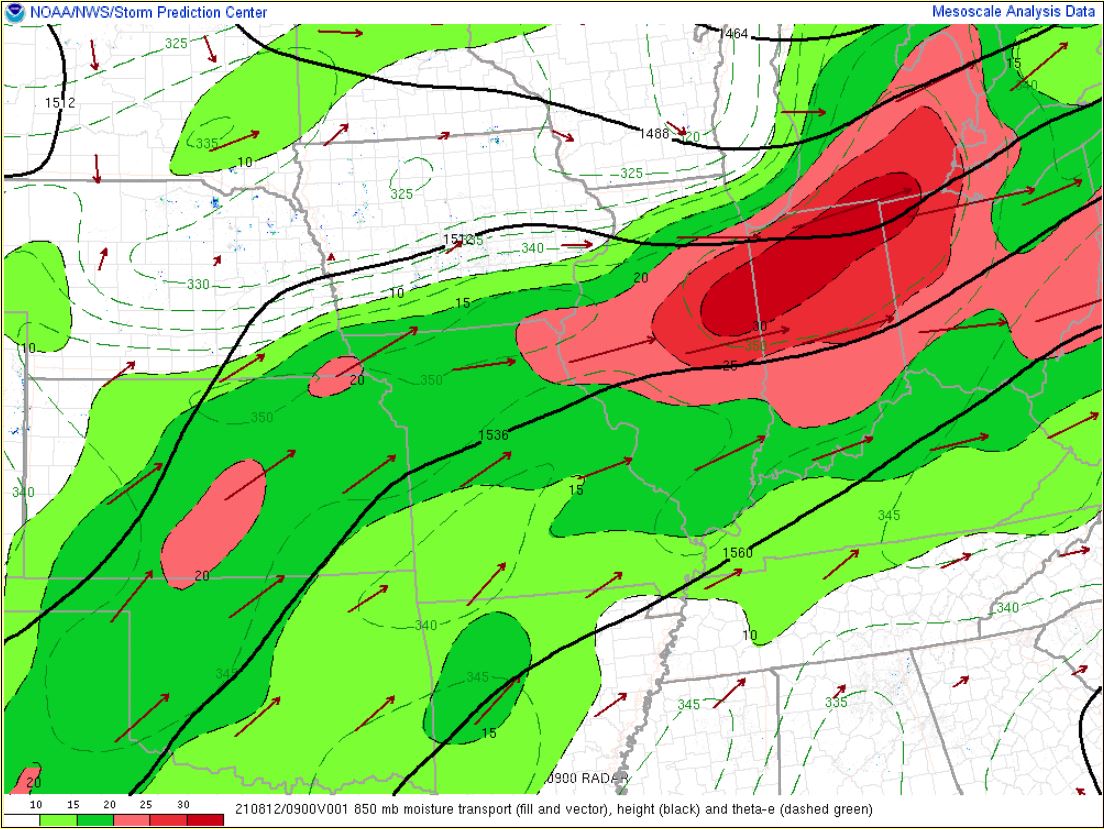
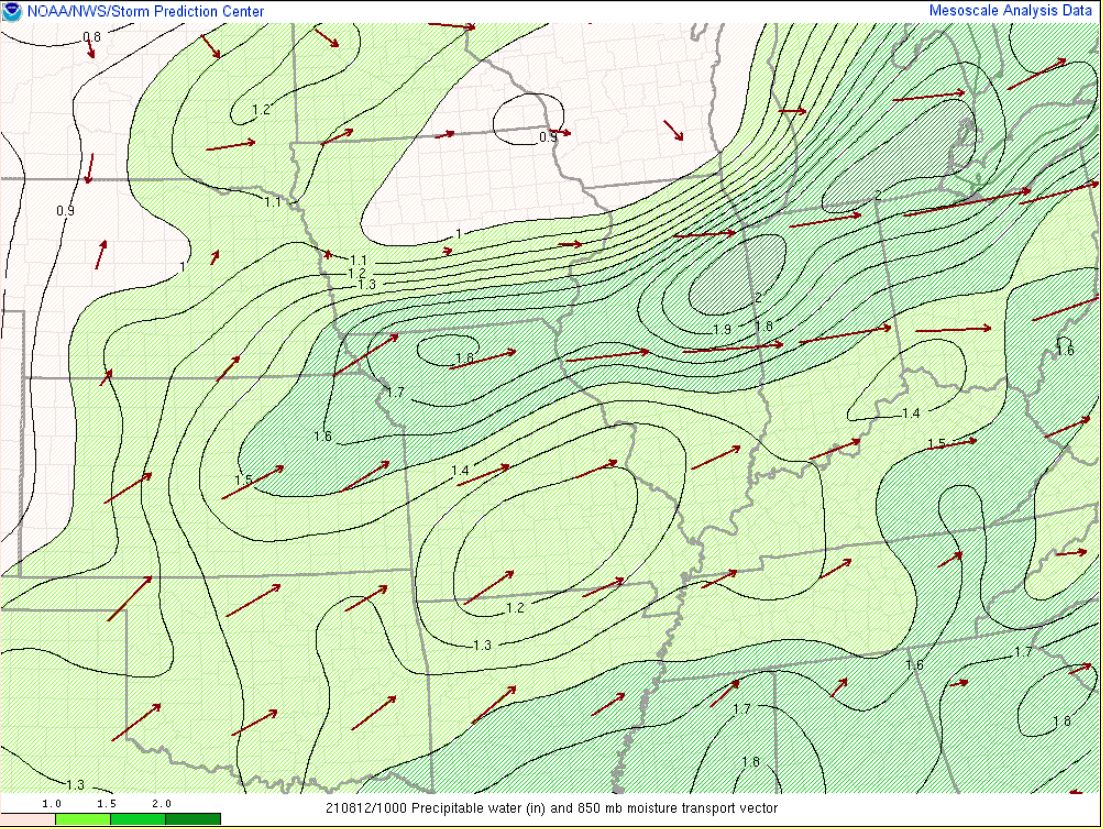
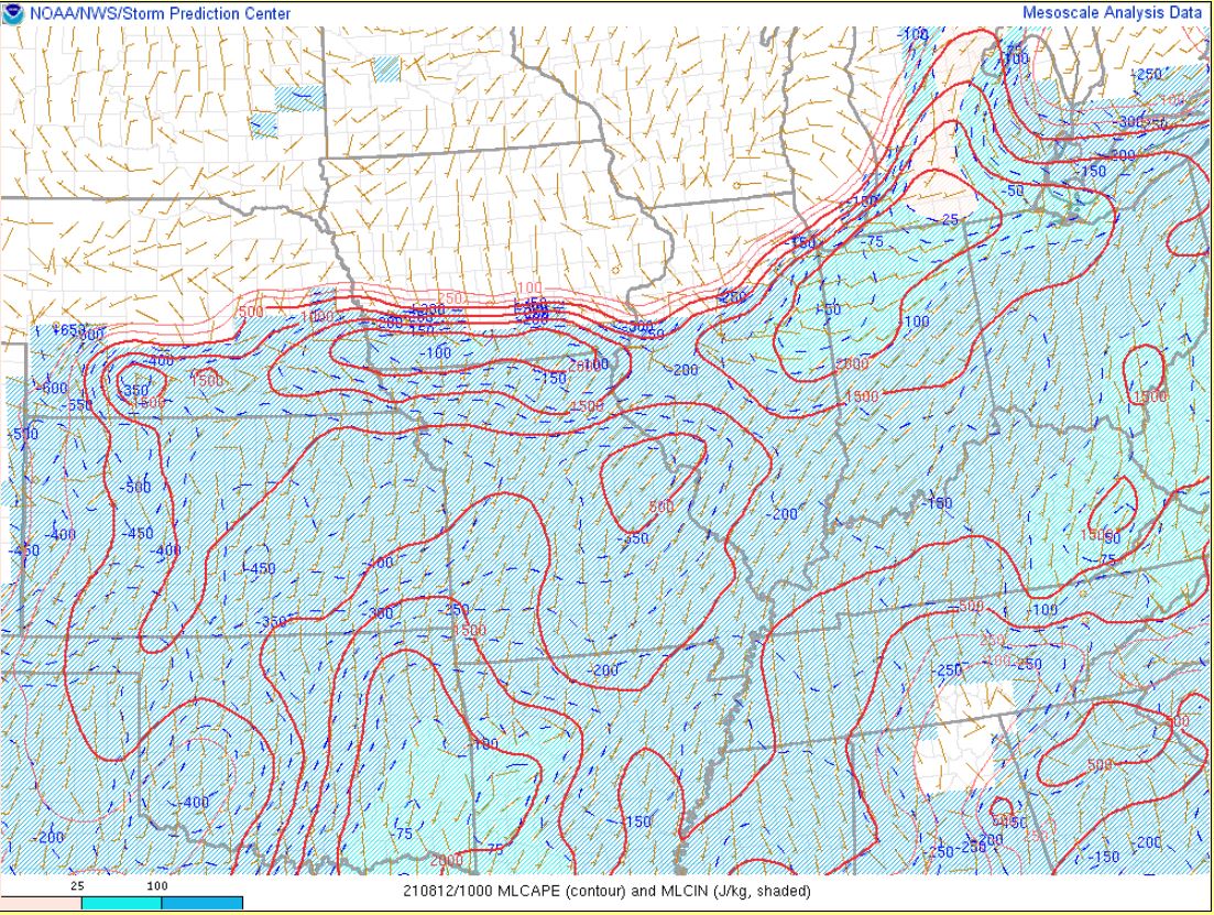
Initially storms struggled to get going during the late evening and overnight hours, despite an intense low level jet and moisture transport into the area (Fig. 1). Precipitable water at the time of the event was up to around 2.1 inches (Fig. 2), which is around 150-175% percent of normal for this time of year. This was because we initially had little forcing to get anything more than elevated non-severe storms in southern MI, and there was a capping inversion in place (CIN in Fig. 3) . By morning however, the mid level trough (Fig. 4) approached the area and gave us enough lift to overcome this and access the instability in the low levels (MLCAPE in Fig. 3) despite it being so early in the morning when it's typically difficult to get storms like these because it is often so stable. This allowed the storms to intensify rapidly and produce damaging winds. To learn more about thunderstorm ingredients and lifecycle, check out our spotter training video here.
 |
 |
 |
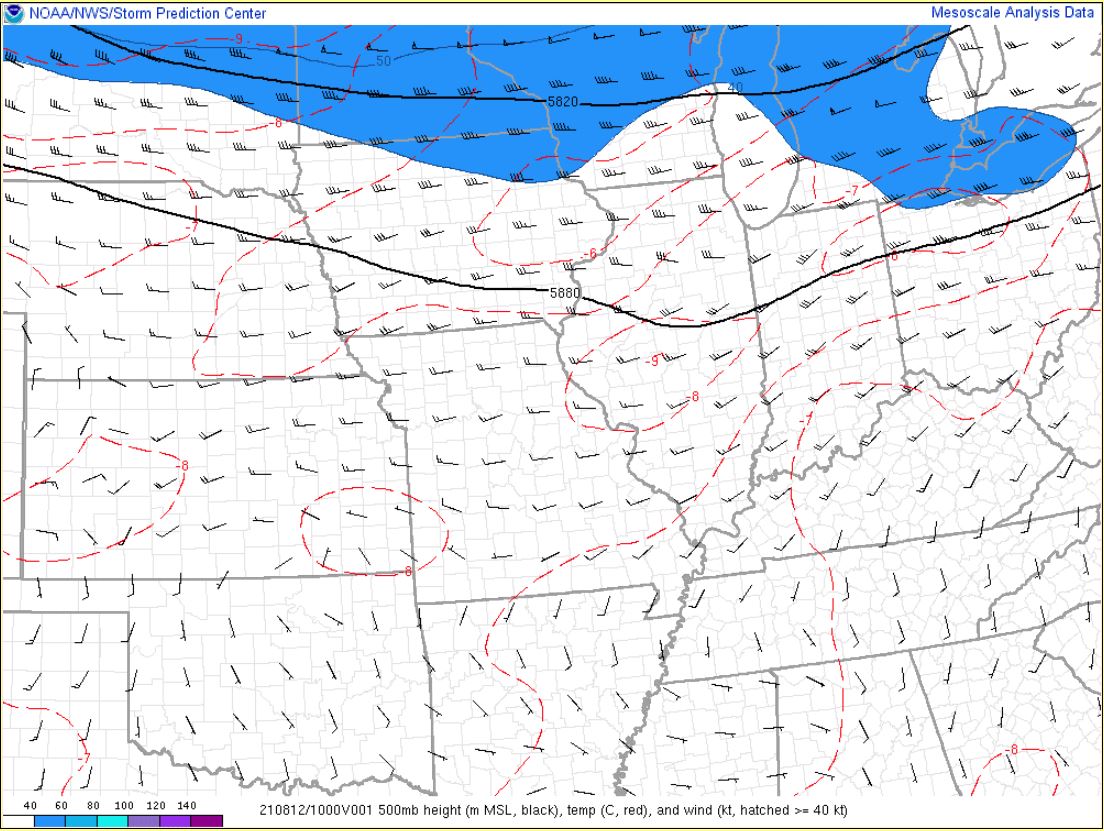 |
| Figure 1: 5 am EDT 8/12/21: 850 mb Moisture transport (fill and vector), height (black), and theta-e (dashed green). Image from SPC Mesoanalysis Archive. | Figure 2: 6 am EDT 8/12/21: Precipitable Water (in) and 850 mb Moisture Transport Vectors. Image from SPC Mesoanalysis Archive. | Figure 3: 6 am EDT 8/12/21: MLCAPE (J/kg, red contour) and MLCIN (J/kg, blue shading). | Figure 4: 6 am EDT 8/12/21: 500mb height (m MSL, black), temp (C, red), and wind (kt, hatched>=40kts). |
 |
Media use of NWS Web News Stories is encouraged! Please acknowledge the NWS as the source of any news information accessed from this site. |
|

