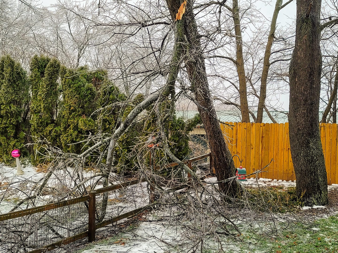
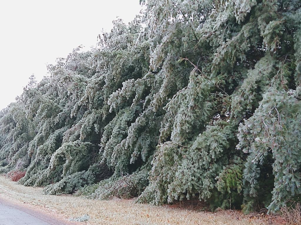
A low pressure system lifted northeast from the Central Plains into the Great Lakes region Friday January 1st, 2021, which brought a wintry mix of freezing rain/drizzle, rain, sleet, and snow to the IWX forecast area. Most locations received around 0.1 to 0.2" of ice accumulation, with a few slightly higher amounts up to 0.25". There were reports of ice-induced power outages, tree/structure damage, and numerous vehicle accidents. Northwestern portions of the forecast area saw a transition to snow in the wake of the system, with totals of 1 to 3 inches of accumulation.
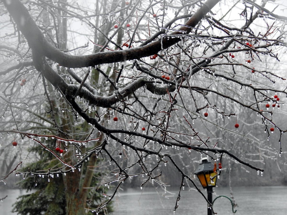
Ice accumulation January 1st, 2021 (Photo Sharon Sheron, Grover Hill, OH)
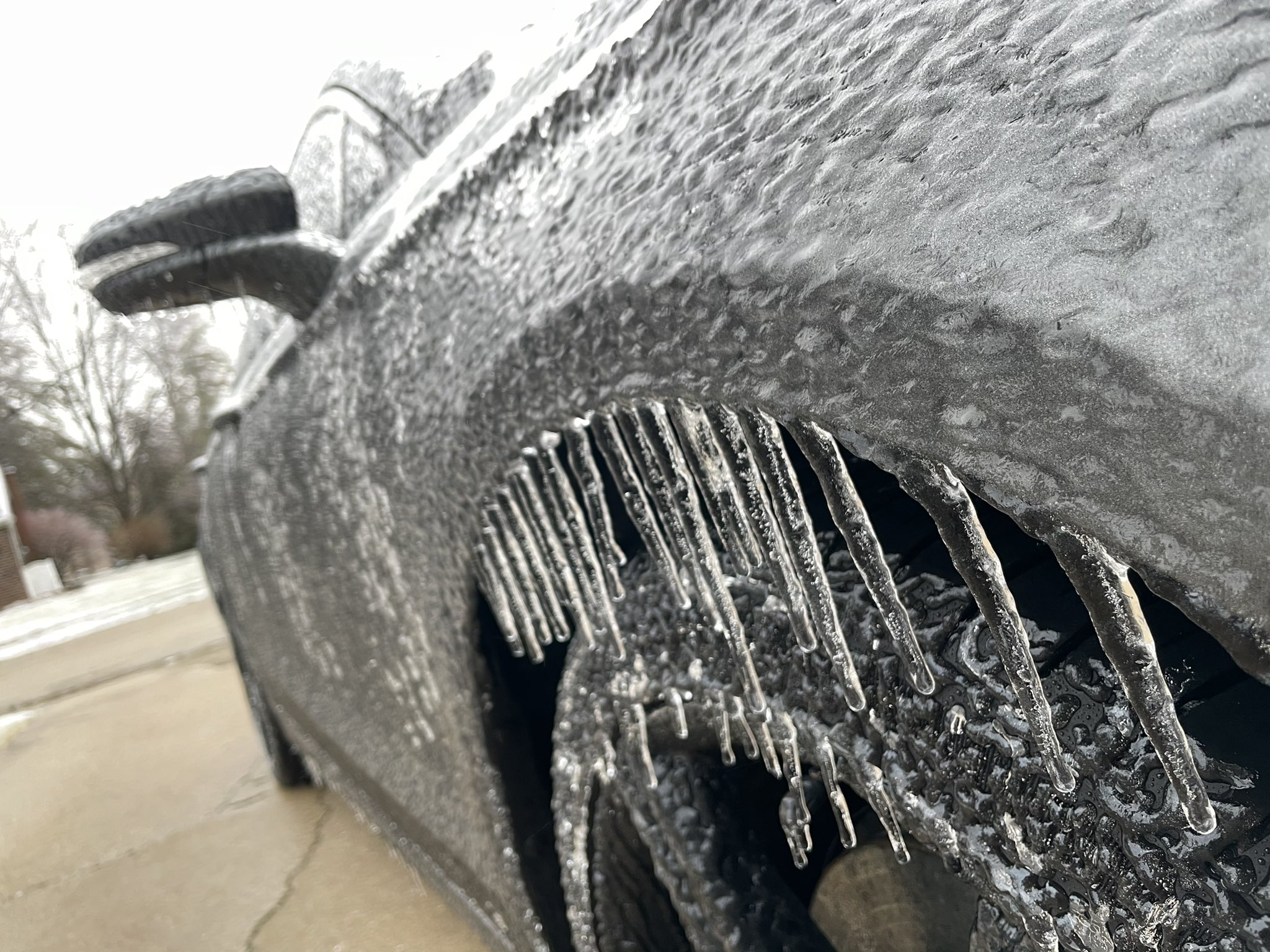
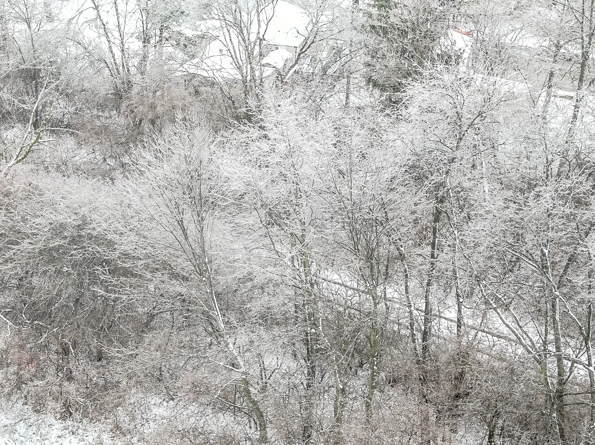
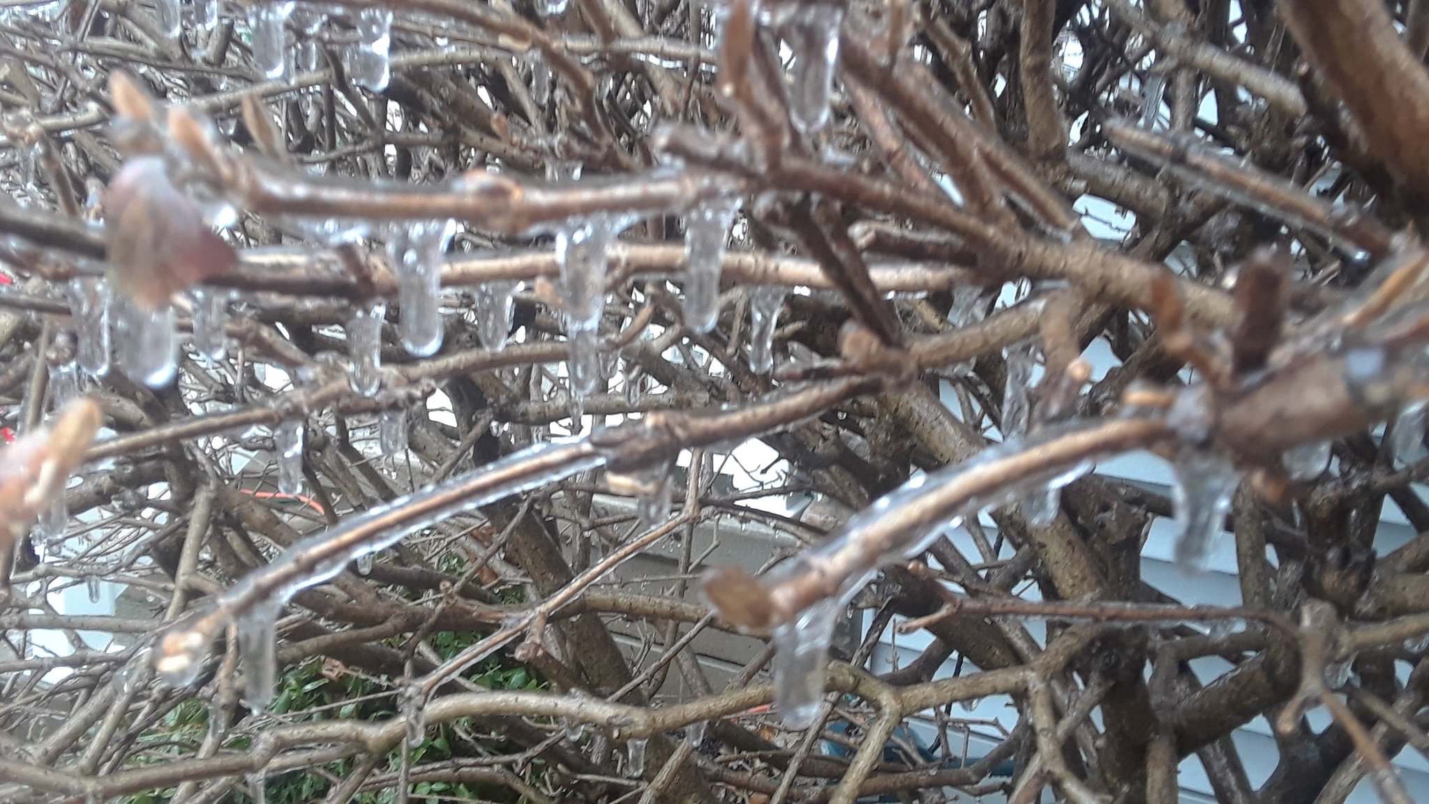
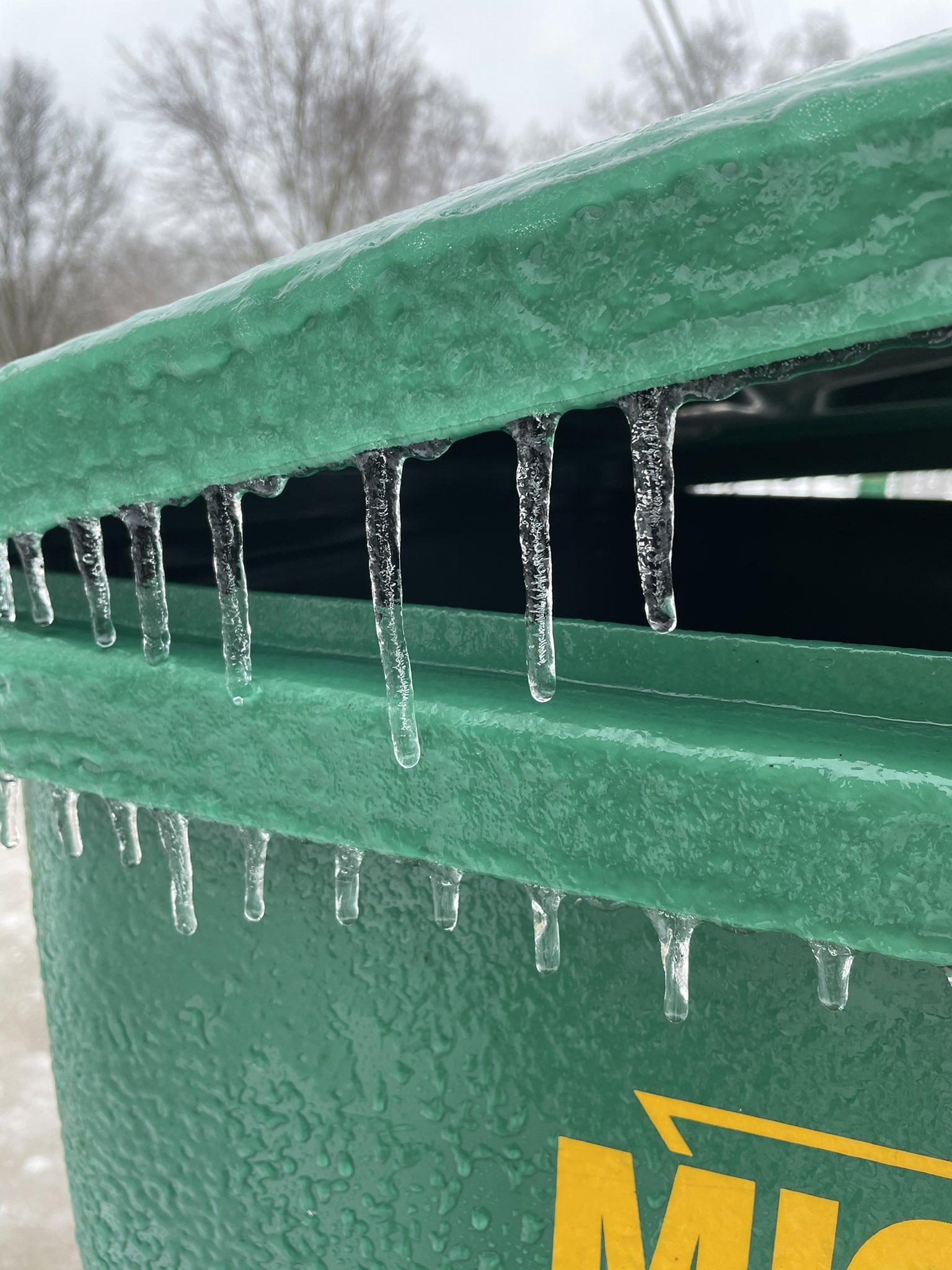
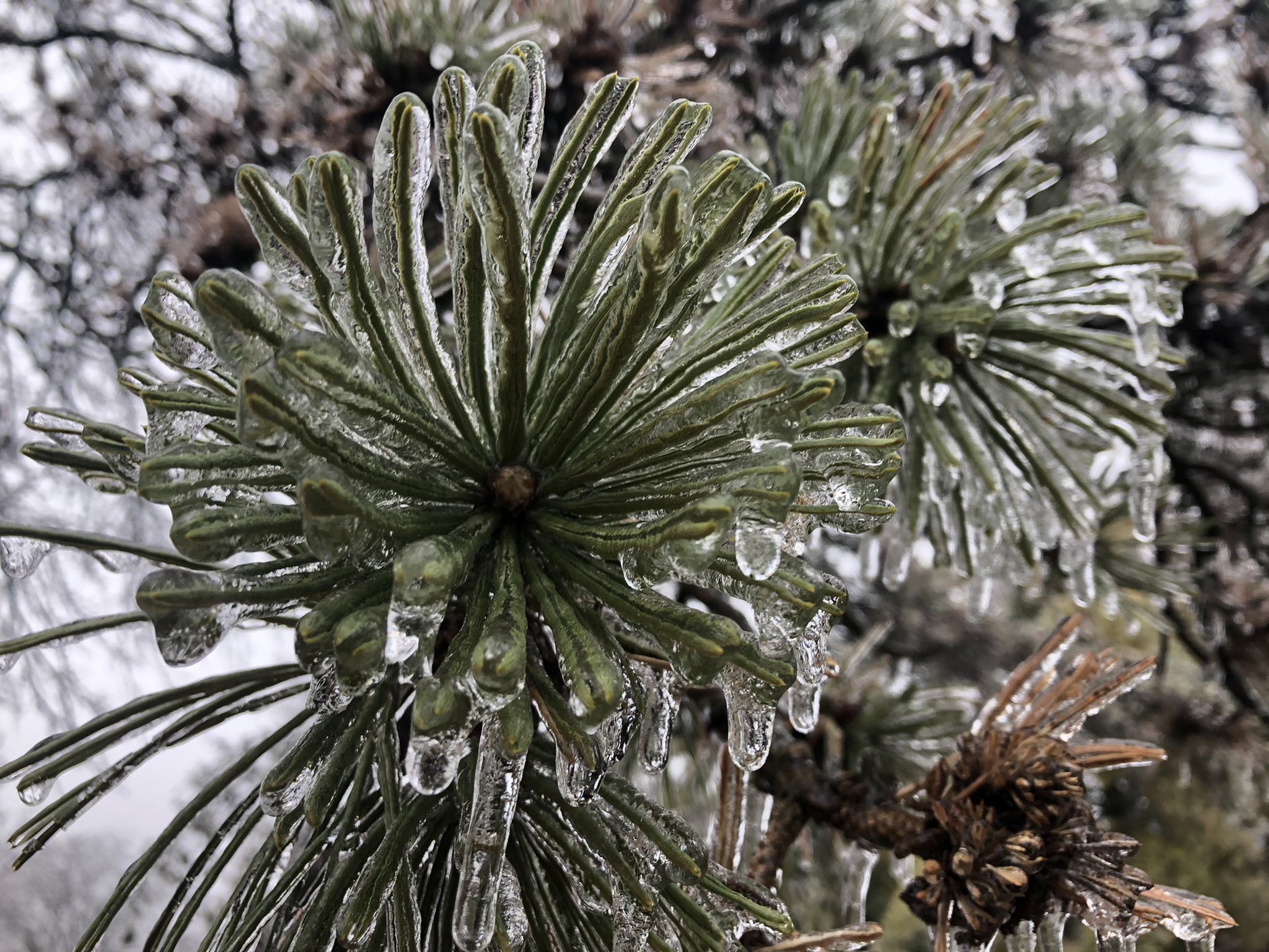
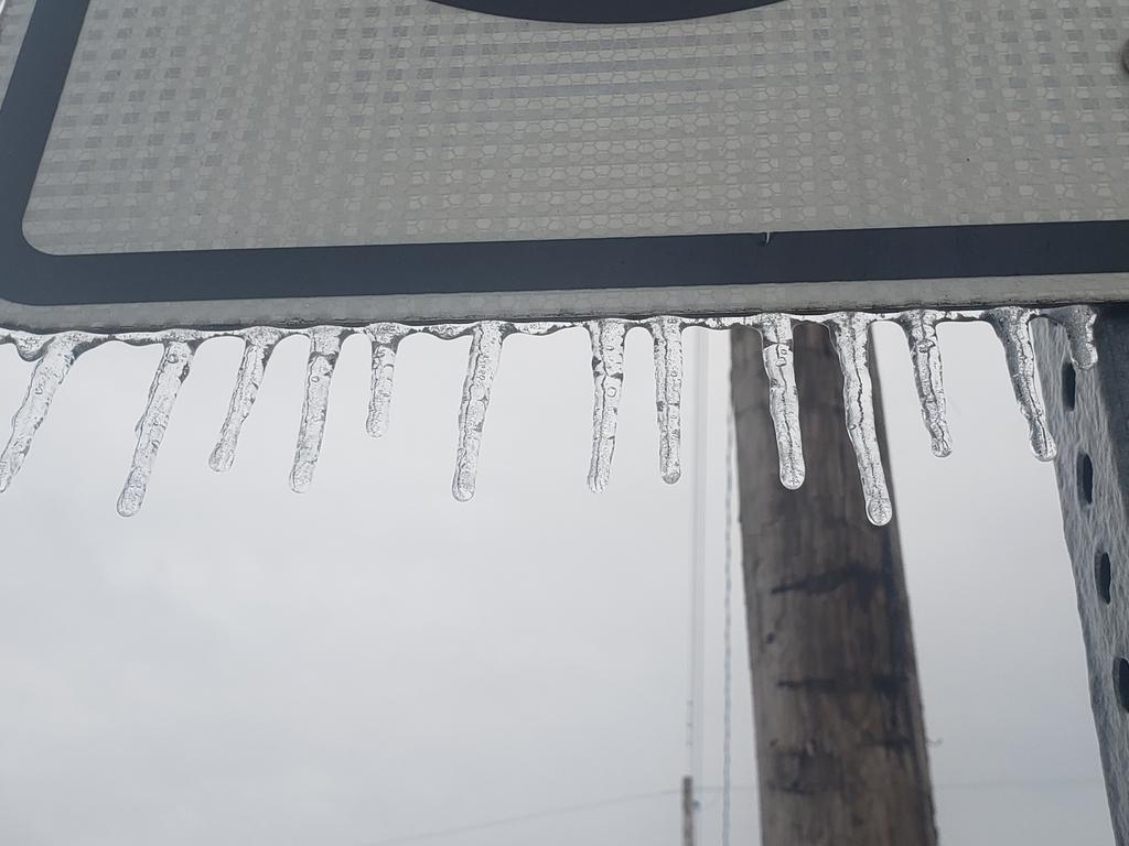
Thank you to those who submitted these great photos we received of the ice accumulation. Around 0.1 to 0.2" of ice accumulation occurred in most locations, with a few slightly higher amounts up to 0.25". There were reports of ice-induced power outages, tree/structure damage, and numerous vehicle accidents.
 |
 |
 |
 |
| Ice Accretion in Fort Wayne, IN (Aaron Orgen on Twitter) |
Ice Accretion in Bluffton, IN (jtinneywx on Twitter) |
Ice Accretion in Nappanee, IN (RobertKurtz3 on Twitter) |
Ice Accretion in Niles, MI. (Emily Kennedy and ABC57News) |
 |
 |
 |
 |
| Ice Accretion in Ft. Wayne, IN (BeverlyPerry and WFFT on Twitter) |
Ice Accretion in Waterloo, IN (wxscoop on Twitter) |
Ice Accretion in Laporte, IN (Joseph Vorrier on Facebook) |
Ice Accretion in Wauseon, OH (Ben Kessler on Twitter) |
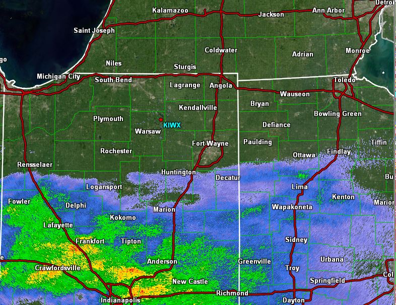
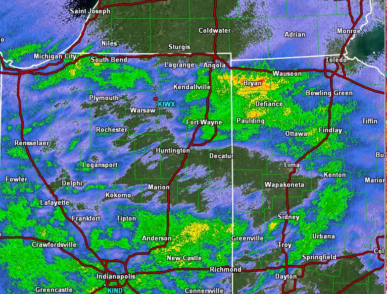
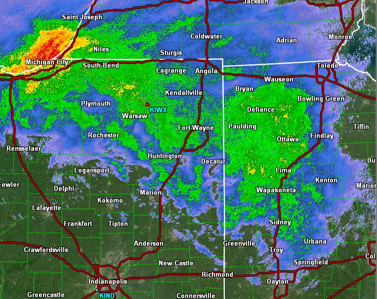
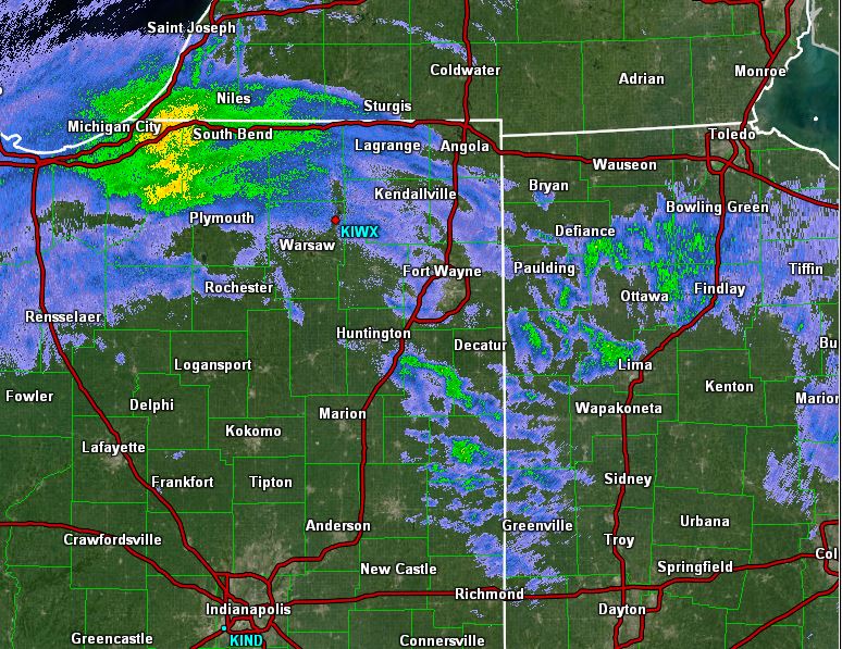
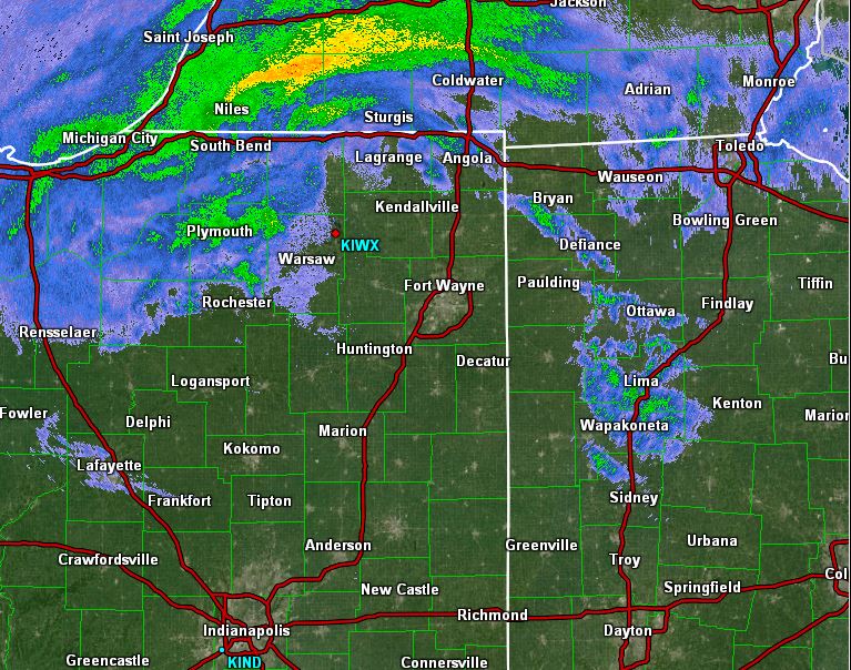
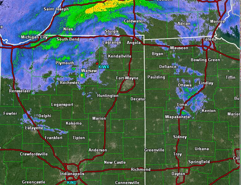
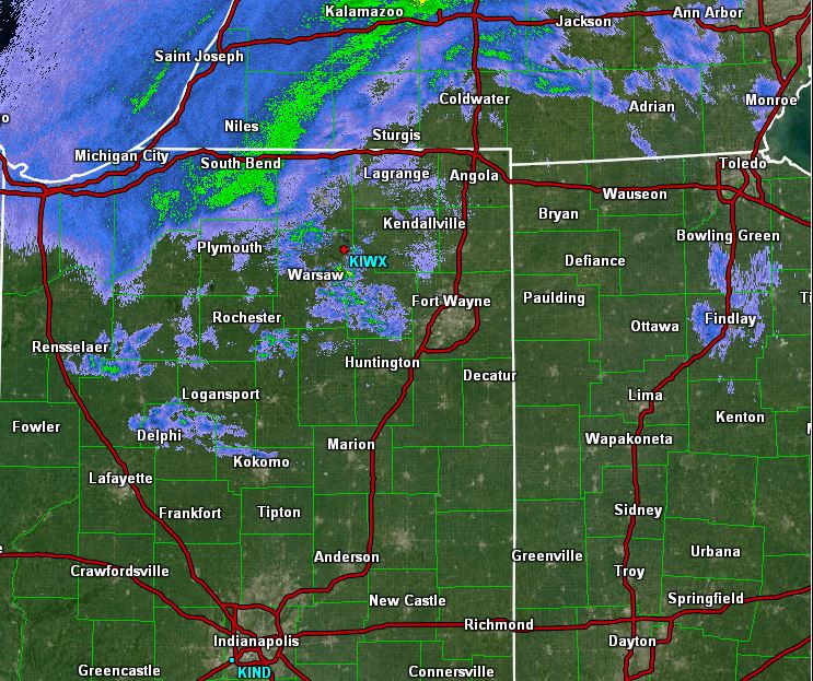
Here are some radar snapshots from the event. Precipitation generally lifted from the southwest to the northeast through the event. Figures 1-3 show the initial push, with the predominant precipitation type as freezing rain transitioning to rain. By 4 pm the area was seeing light drizzle or light rain (somewhat of a lull), then it transitioned to a snow in the northwest behind the system as it shifted out of the area.
 |
 |
 |
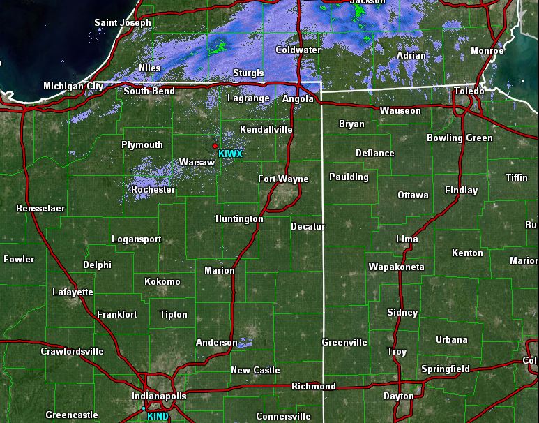 |
| Figure 1. IWX Radar Reflectivity (Z) 0.5 Deg. at 7 am ET on Jan 1st, 2021. Initial push of precipitation. GR2 Analyst | Figure 2. IWX Radar Reflectivity (Z) 0.5 Deg. at 10 am ET on Jan 1st, 2021. Initial push of precipitation. GR2 Analyst | Figure 3. IWX Radar Reflectivity (Z) 0.5 Deg. at 2 pm ET on Jan 1st, 2021. Initial push of precipitation. GR2 Analyst | Figure 4. IWX Radar Reflectivity (Z) 0.5 Deg. at 4 pm ET on Jan 1st, 2021. Lull period. GR2 Analyst |
 |
 |
 |
 |
| Figure 5. IWX Radar Reflectivity (Z) 0.5 Deg. at 9:35 pm ET on Jan 1st, 2021. Snow on the backside of the low (NW). GR2 Analyst | Figure 6. IWX Radar Reflectivity (Z) 0.5 Deg. at 10:35 pm ET on Jan 1st, 2021. Snow on the backside of the low (NW). GR2 Analyst | Figure 7. IWX Radar Reflectivity (Z) 0.5 Deg. at 10:52 pm ET on Jan 1st, 2021. Snow on the backside of the low (NW). GR2 Analyst | Figure 8. IWX Radar Reflectivity (Z) 0.5 Deg. at 11:27 pm ET on Jan 1st, 2021. Snow on the backside of the low (NW). GR2 Analyst |
PUBLIC INFORMATION STATEMENT
NATIONAL WEATHER SERVICE NORTHERN INDIANA
617 AM EST SAT JAN 2 2021

...FREEZING RAIN TOTALS FROM JANUARY 1ST 2021...

LOCATION                     AMOUNT    TIME/DATE       LAT/LON

...INDIANA...

...ALLEN COUNTY...
2 NNW NINE MILE              0.10 IN   1250 PM 01/01   41.00N/85.24W

...DE KALB COUNTY...
WATERLOO                     0.20 IN   0300 AM 01/02   41.43N/85.03W

...ELKHART COUNTY...
1 ESE OSCEOLA                0.25 IN   1000 AM 01/01   41.66N/86.06W
2 ESE JIMTOWN                0.20 IN   0300 PM 01/01   41.62N/85.99W
2 WNW GOSHEN                 0.10 IN   0510 PM 01/01   41.59N/85.88W

...KOSCIUSKO COUNTY...
2 N NORTH WEBSTER            0.15 IN   0700 PM 01/01   41.36N/85.70W
WINONA LAKE                  0.10 IN   0115 PM 01/01   41.23N/85.82W

...LA PORTE COUNTY...
2 SW LA PORTE                0.20 IN   0330 PM 01/01   41.59N/86.73W

...MIAMI COUNTY...
2 ESE BUNKER HILL            0.20 IN   1231 PM 01/01   40.65N/86.07W

...ST. JOSEPH COUNTY...
1 S ROSELAND                 0.10 IN   0100 PM 01/01   41.70N/86.25W

...WELLS COUNTY...
BLUFFTON                     0.20 IN   0100 PM 01/01   40.74N/85.17W
2 SSW TOCSIN                 0.10 IN   0100 PM 01/01   40.81N/85.13W

...MICHIGAN...

...BERRIEN COUNTY...
NILES                        0.10 IN   0230 PM 01/01   41.83N/86.25W

...OHIO...

...DEFIANCE COUNTY...
2 NW BRUNERSBURG             0.10 IN   0215 PM 01/01   41.33N/84.41W

...PUTNAM COUNTY...
OTTAWA                       0.10 IN   1015 AM 01/01   41.02N/84.04W

...VAN WERT COUNTY...
1 NNW VAN WERT               0.12 IN   0750 PM 01/01   40.87N/84.58W

OBSERVATIONS ARE COLLECTED FROM A VARIETY OF SOURCES WITH VARYING
EQUIPMENT AND EXPOSURES. WE THANK ALL VOLUNTEER WEATHER OBSERVERS
FOR THEIR DEDICATION. NOT ALL DATA LISTED ARE CONSIDERED OFFICIAL.

$$
PUBLIC INFORMATION STATEMENT
NATIONAL WEATHER SERVICE NORTHERN INDIANA
620 AM EST SAT JAN 2 2021

...SNOWFALL REPORTS...

LOCATION                     AMOUNT    TIME/DATE       LAT/LON

...INDIANA...

...ELKHART COUNTY...
1.9 W ELKHART                0.1 IN    1200 AM 01/02   41.68N/86.00W

...KOSCIUSKO COUNTY...
2 N NORTH WEBSTER            0.1 IN    1200 AM 01/02   41.36N/85.70W

...LA PORTE COUNTY...
MICHIGAN CITY                2.5 IN    1245 AM 01/02   41.71N/86.88W

...ST. JOSEPH COUNTY...
SOUTH BEND                   1.9 IN    1200 AM 01/02   41.70N/86.25W
1 NW SOUTH BEND              1.1 IN    1045 PM 01/01   41.69N/86.28W

...WHITLEY COUNTY...
COLUMBIA CITY 1.5 NNW        0.2 IN    0500 AM 01/02   41.18N/85.49W

...MICHIGAN...

...BERRIEN COUNTY...
STEVENSVILLE                 2.5 IN    1115 PM 01/01   42.01N/86.53W
FAIR PLAIN                   1.3 IN    1130 PM 01/01   42.08N/86.45W

OBSERVATIONS ARE COLLECTED FROM A VARIETY OF SOURCES WITH VARYING
EQUIPMENT AND EXPOSURES. WE THANK ALL VOLUNTEER WEATHER OBSERVERS
FOR THEIR DEDICATION. NOT ALL DATA LISTED ARE CONSIDERED OFFICIAL.

$$
PRELIMINARY LOCAL STORM REPORT...SUMMARY
NATIONAL WEATHER SERVICE NORTHERN INDIANA
630 AM EST SAT JAN 2 2021

..TIME...   ...EVENT...      ...CITY LOCATION...     ...LAT.LON...
..DATE...   ....MAG....      ..COUNTY LOCATION..ST.. ...SOURCE....
            ..REMARKS..

1000 AM     FREEZING RAIN    1 E OSCEOLA             41.66N 86.06W
01/01/2021  E0.25 INCH       ELKHART            IN   PUBLIC

            MULTIPLE LARGE PINE TREE BRANCHES DOWNED
            FROM ICE, 1 HITTING POWER LINE AND DAMAGING
            ELECTRICAL POLE.

0300 AM     FREEZING RAIN    WATERLOO                41.43N 85.03W
01/02/2021  E0.20 INCH       DE KALB            IN   TRAINED SPOTTER

            LARGE LIMB COLLAPSED ON AND DID DAMAGE TO A
            MOBILE HOME. COLLAPSE WAS DUE TO ICE
            ACCUMULATION FROM EARLIER.

0330 PM     FREEZING RAIN    2 SW LA PORTE           41.59N 86.73W
01/01/2021  M0.20 INCH       LA PORTE           IN   COCORAHS

            2 TENTHS OF AN INCH OF ICE ACCUMULATION SO
            FAR. SOME TREE LIMBS BREAKING.

0300 PM     FREEZING RAIN    2 E JIMTOWN             41.62N 85.99W
01/01/2021  E0.20 INCH       ELKHART            IN   PUBLIC

            6 INCH LIMB FELL AND GUTTERS ON A HOUSE WERE
            DAMAGED.

0100 PM     FREEZING RAIN    BLUFFTON                40.74N 85.17W
01/01/2021  M0.20 INCH       WELLS              IN   TRAINED SPOTTER

            SEVERAL SMALL LIMBS BROKEN.
&&
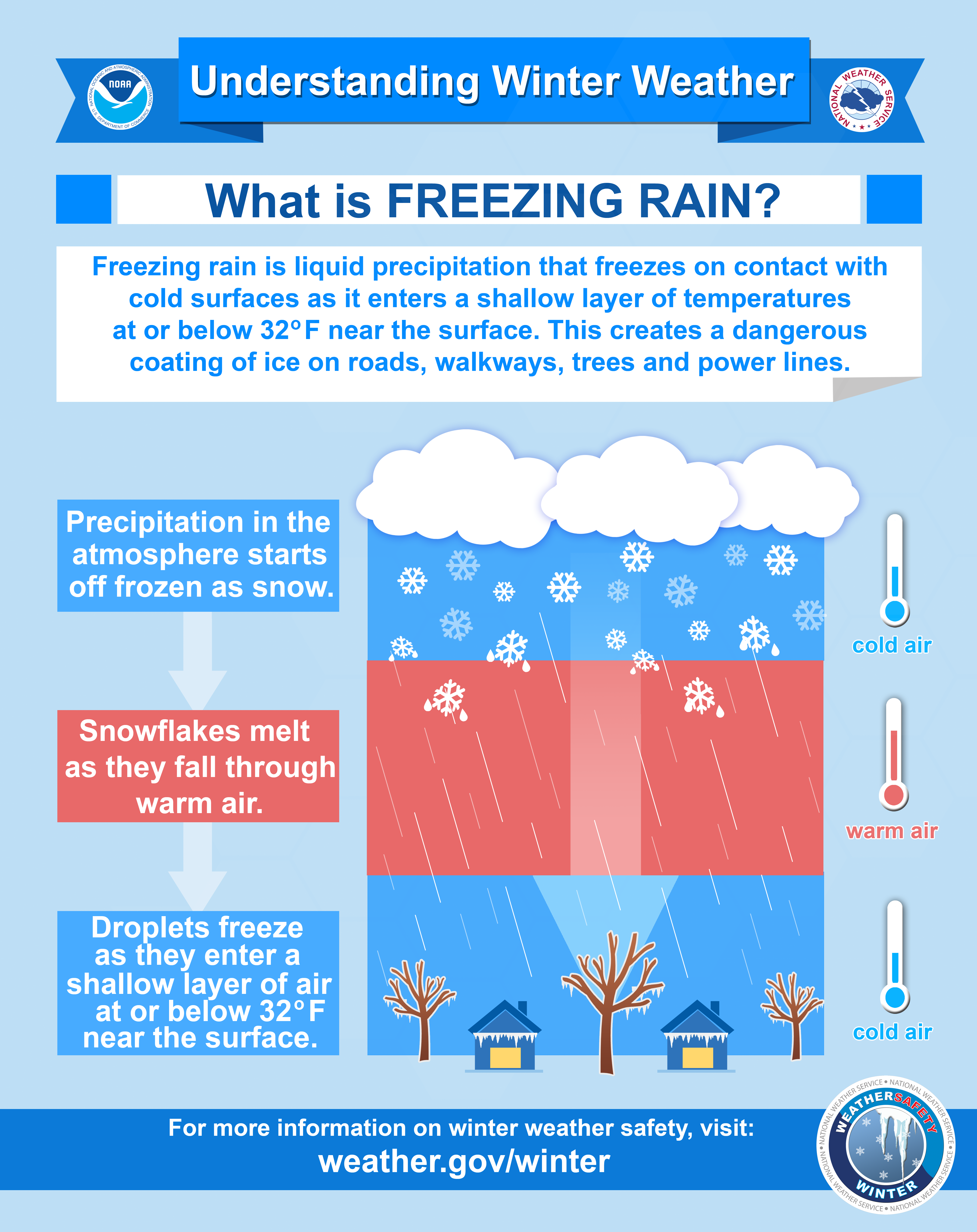
This event had a pot-pourri of precipitation types, from rain and drizzle to freezing rain, sleet, and snow. How do the different winter precipitation types form? A graphical representation is shown below in Fig. 1, with the details on freezing rain in Figure 2.
 |
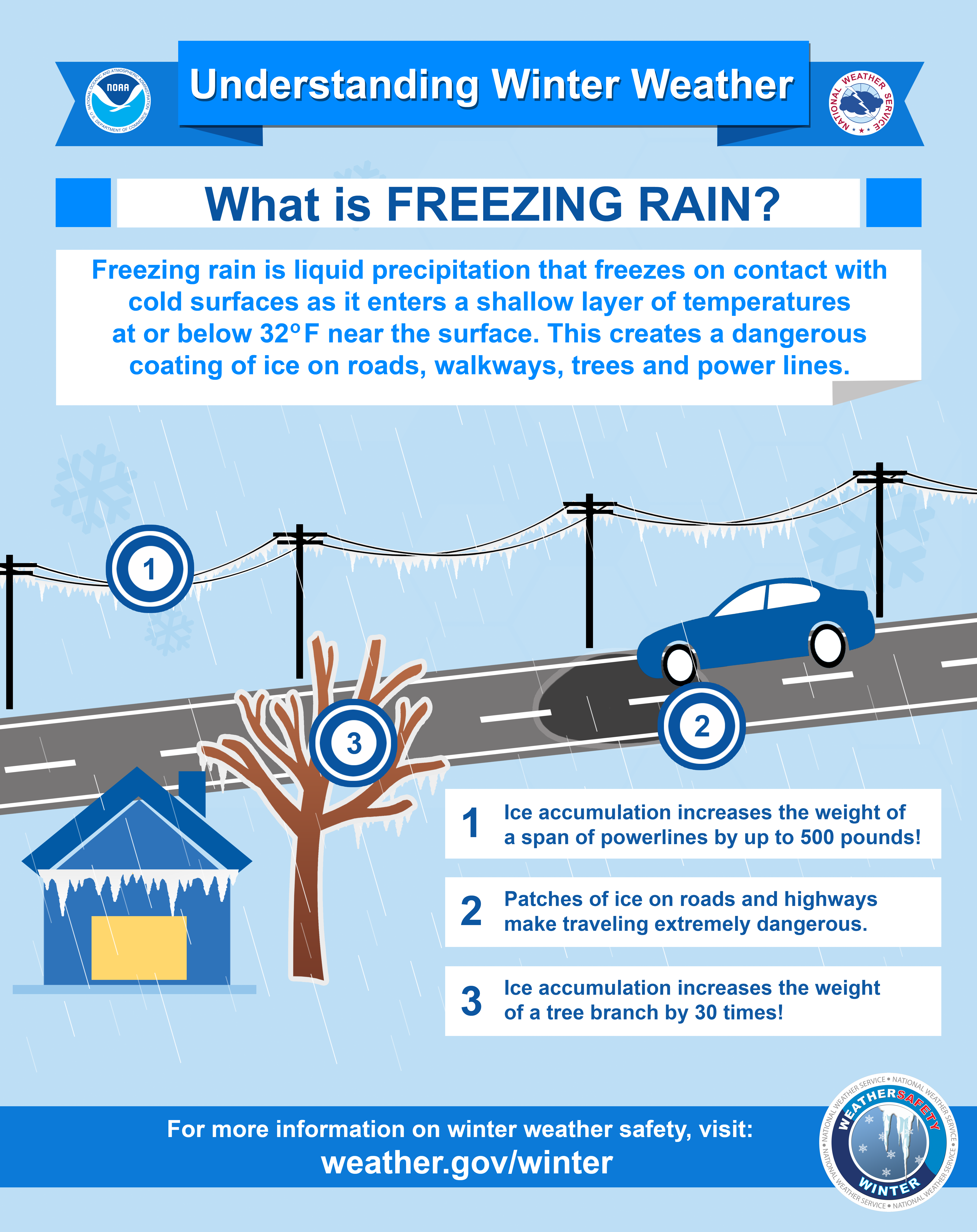 |
| Figure 1: How Does Freezing Rain Form? Visit NWS Winter Safety Page | Figure 2: What is Freezing Rain? Visit NWS Winter Safety Page |
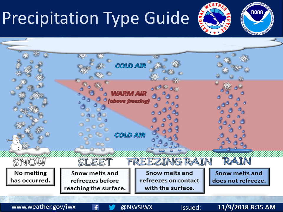 |
| Figure 3: How do the various winter precipitation types form? Visit NWS Winter Safety Page |
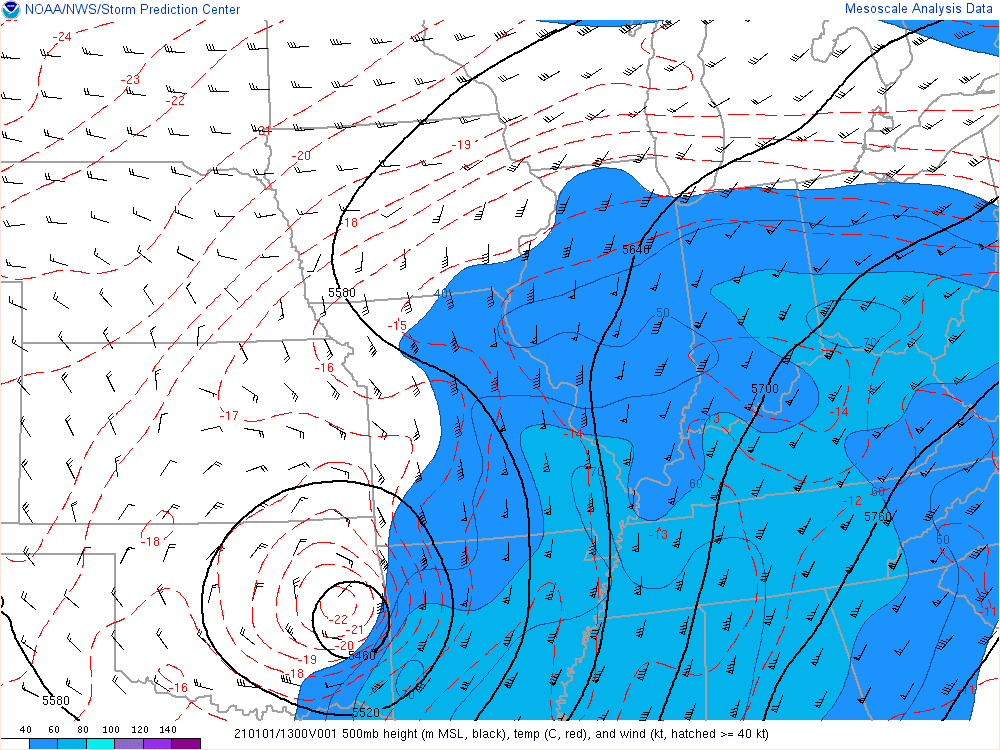
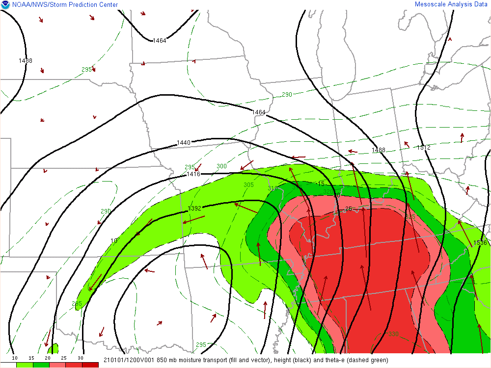
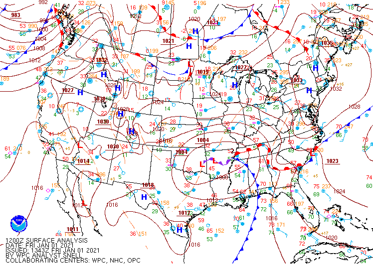
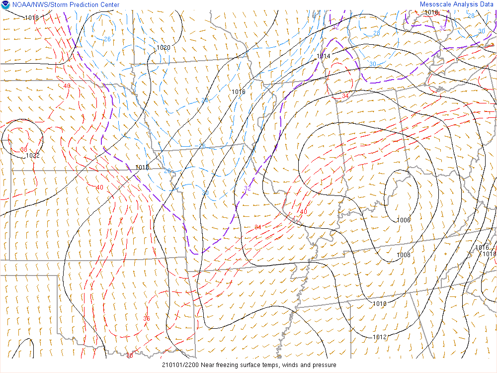
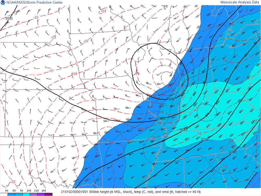
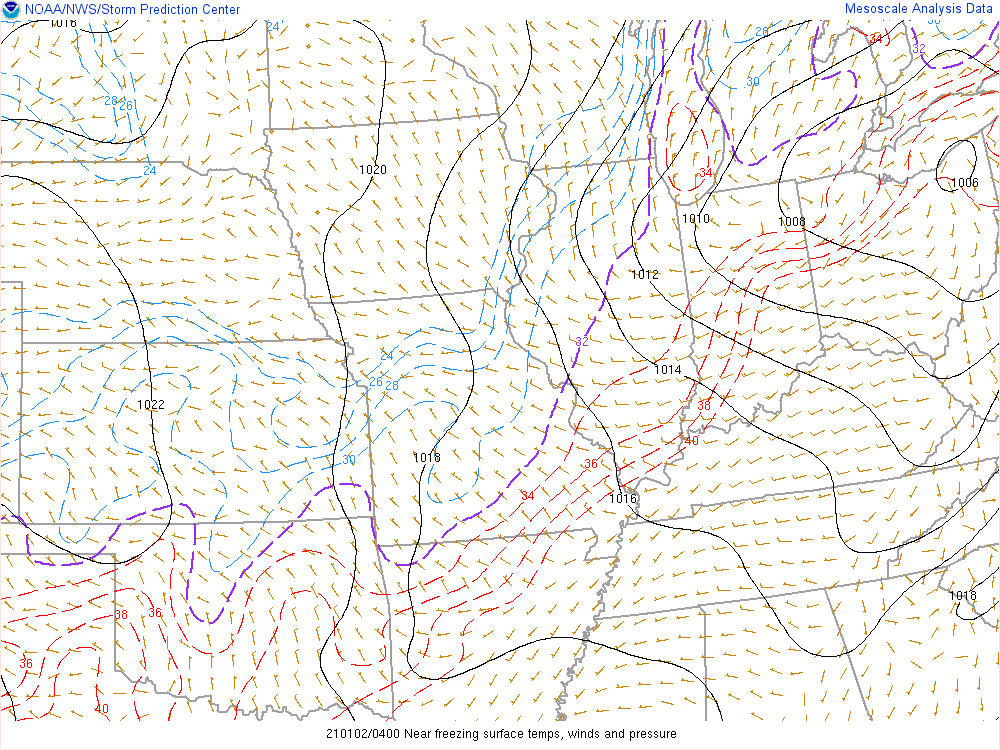
A closed low aloft and the subsequent surface low pressure system lifted from the Central Plains into the Northern Indiana forecast area (CWA Map here) Friday January 1st into Saturday January 2nd, 2021. The system had a strong low level jet, which led to abundant moisture and warm air in the mid levels being transported over northern Indiana, southwest Lower Michigan, and northwest Ohio. The precipitation fell into the colder surface air below, which hovered around freezing. The precipitation started out as a mix of freezing rain and sleet, then mixed with rain as temperatures warmed into the afternoon. You can see the progression of the warm layer aloft through the morning and early afternoon in the images below, and the rising surface temperatures that caused a changeover back to rain. Later in the evening (into January 2nd), the warm air aloft shifted eastward and the precipitation on the backside of the low pressure system transitioned to all snow. This brought between 1 and 3 inches of snow accumulation to the far northwestern CWA Friday evening. Want to learn more? Follow our timeline of environmental conditions below.
Warm air lifts into the CWA aloft and cold (below freezing air) is at the surface. Precipitation type was predominantly freezing rain and sleet during these times, which you can visualize with the weather depiction images (Figs. 11-12). As surface air temperatures rose towards/above freezing, we saw a transition to more rain (warm through the column).
 |
 |
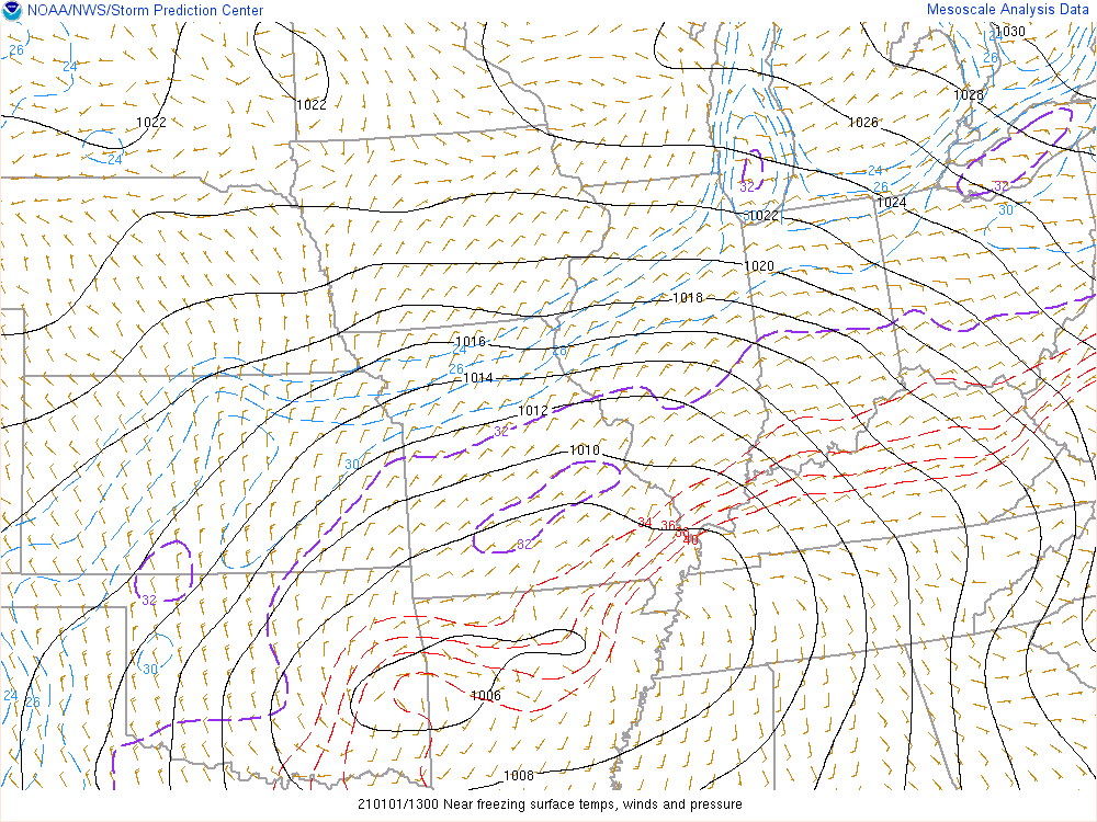 |
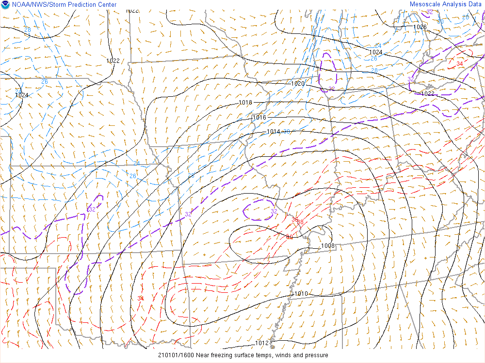
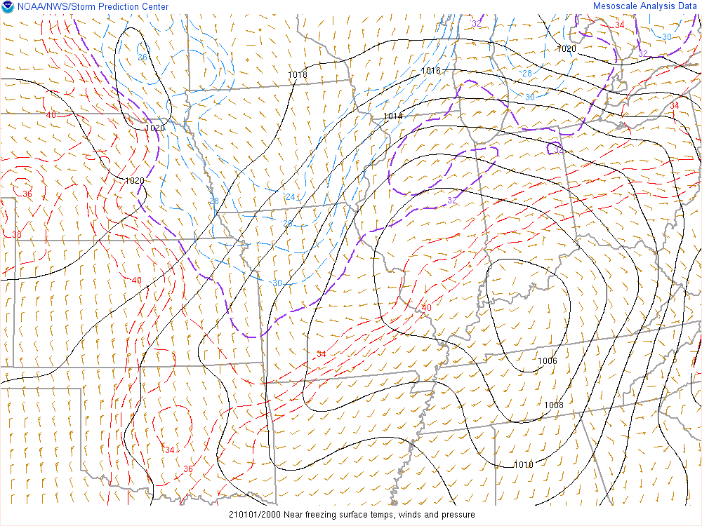
| Figure 4: Closed Low at 500mb at 8 am ET Jan 1st, 2021. Fill is wind speed. Black lines are heights. SPC Mesoanalysis Archive | Figure 5: 850mb moisture transport (fill and vector) and warm air at 7 am ET Jan 1st, 2021. SPC Mesoanalysis Archive | Figure 6: Near surface temperatures around freezing (purple contour), above freezing in red (below in blue). Cold air is in place over the CWA at 8 am ET Jan 1st, 2021. SPC Mesoanalysis Archive |
 |
 |
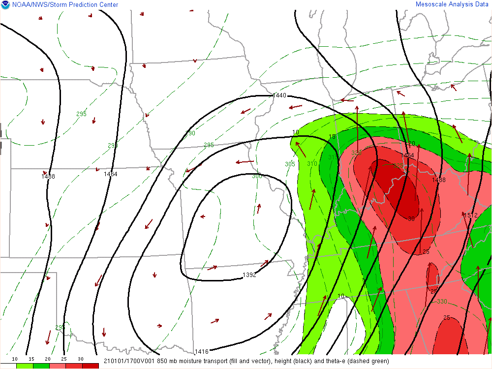 |
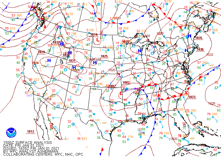
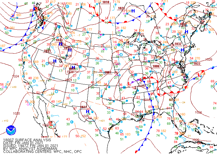
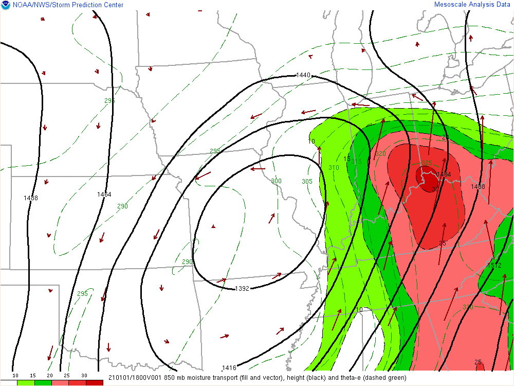
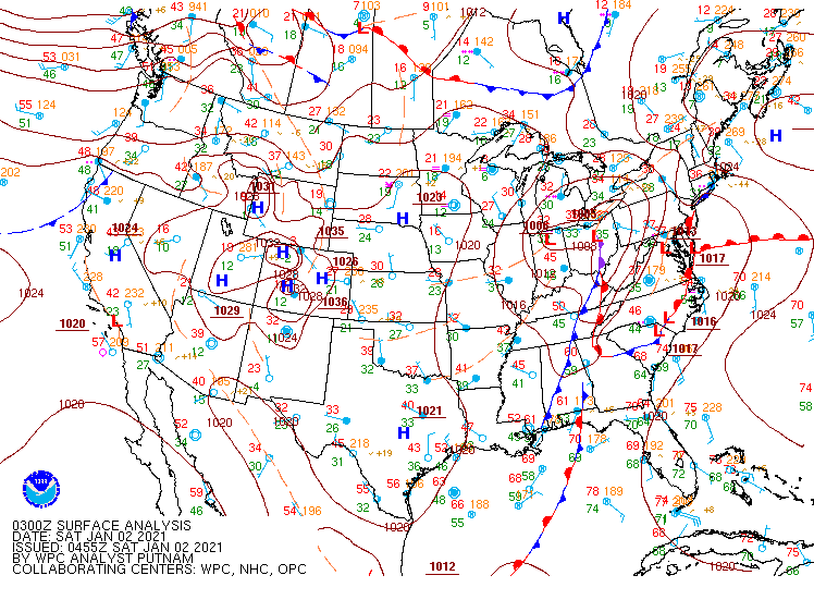
| Figure 7: At 7 am ET Jan 1st, 2021. Surface low pressure system lifting from the plains. WPC Surface Analysis Archive. | Figure 8: At 10 am ET Jan 1st, 2021.Surface low pressure system lifting from the plains. WPC Surface Analysis Archive. | Figure 9: Warm air infiltrating the area at 850mb with large moisture transport around 12 pm ET Jan 1st, 2021. SPC Mesoanalysis Archive |
 |
 |
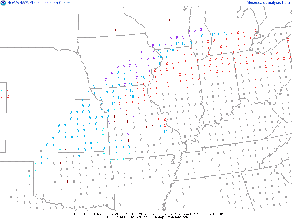 |
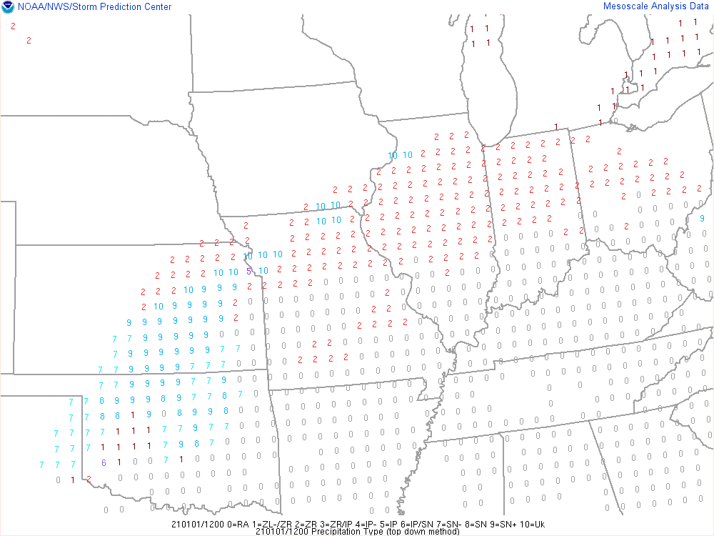
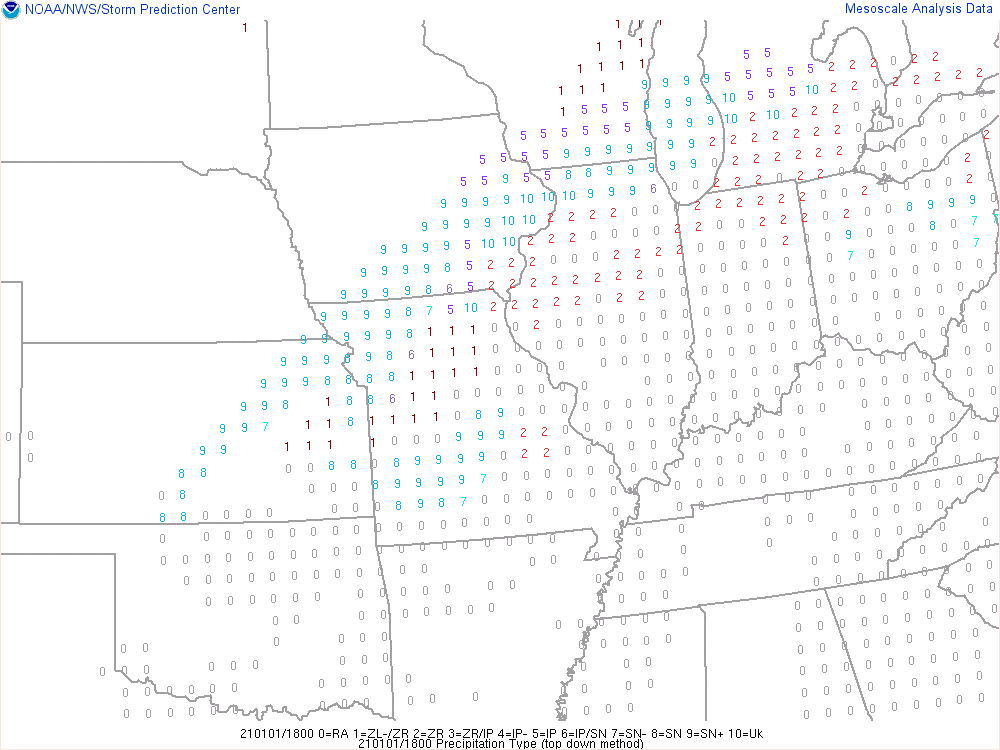
| Figure 10: Near surface temperatures around freezing (purple contour), above freezing in red (below in blue). Surface temperatures rising with daytime heating at 11 am ET Jan 1st, 2021. SPC Mesoanalysis Archive | Figure 11: Weather Depiction at 7 am ET Jan 1st, 2021. The numbers all represent weather types. Rain (1), Freezing Rain (light 1, moderate 2), Sleet (5), and Unknown (10). SPC Mesoanalysis Archive | Figure 12: Weather Depiction at 11 am ET Jan 1st, 2021. The numbers all represent weather types. Rain (1), Freezing Rain (light 1, moderate 2), Sleet (5), and Unknown (10). SPC Mesoanalysis Archive |
The surface and upper level low lifted further northeastward through the afternoon (Figs. 13-15, 21-22). Warm air aloft (Figs. 16-18) and rising surface temperatures (Figs. 19-20) led to a transition to mostly rain during the afternoon, with a few pockets of mixed precipitation in colder areas (weather depiction in Fig. 23 and 24).
 |
 |
 |
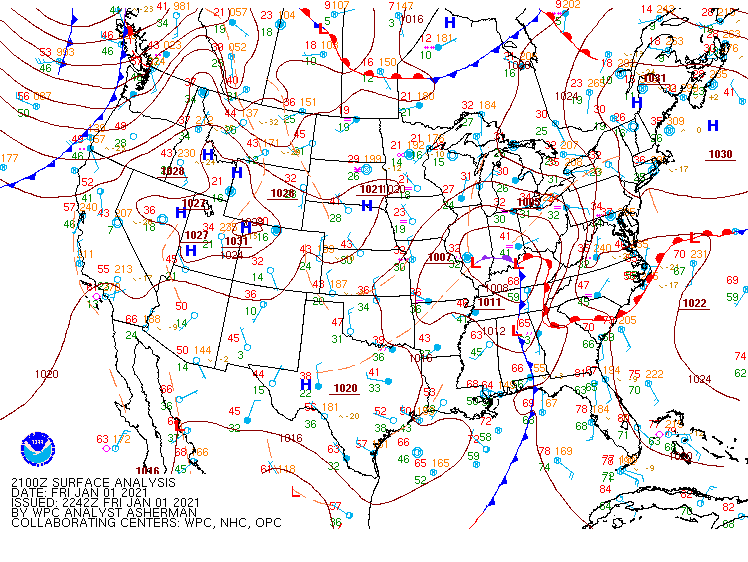
| Figure 13: At 1 pm ET Jan 1st, 2021. Surface low impacting our forecast area. WPC Surface Analysis Archive. | Figure 14: At 4 pm ET Jan 1st, 2021. Surface low impacting our forecast area. WPC Surface Analysis Archive. | Figure 15: At 7 pm ET Jan 1st, 2021. Surface low impacting our forecast area. WPC Surface Analysis Archive. |
 |
 |
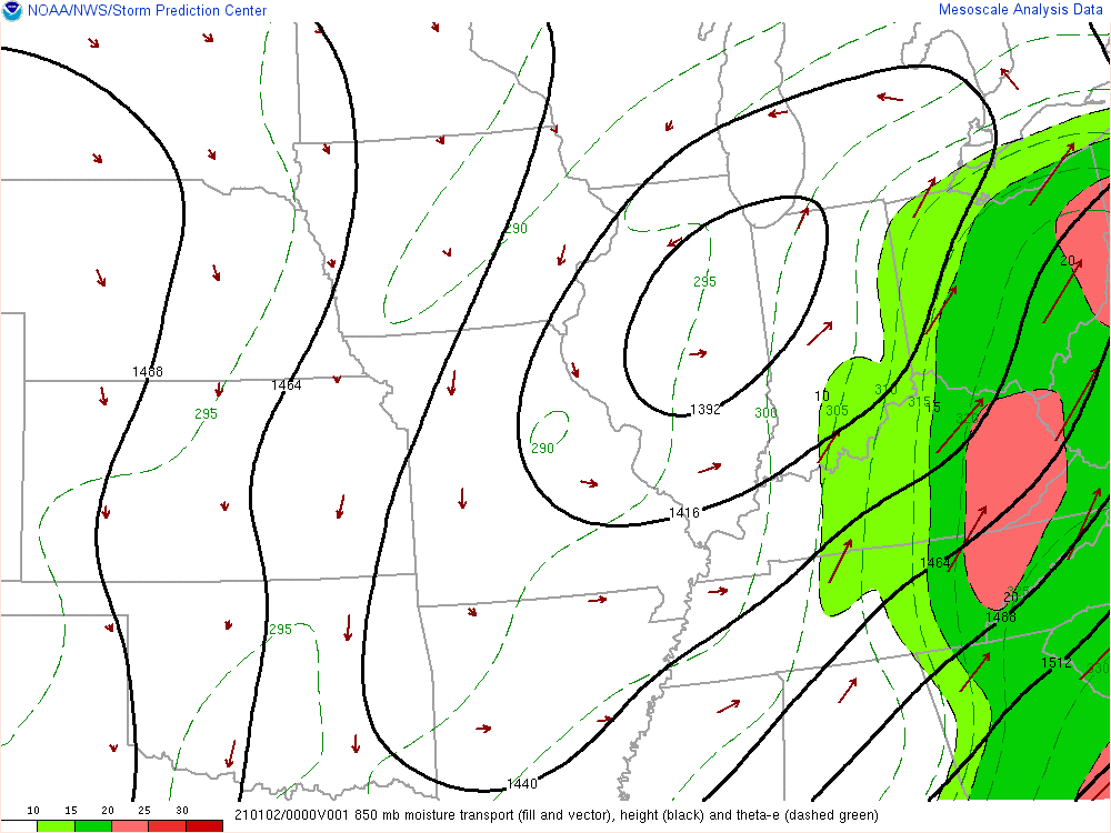 |
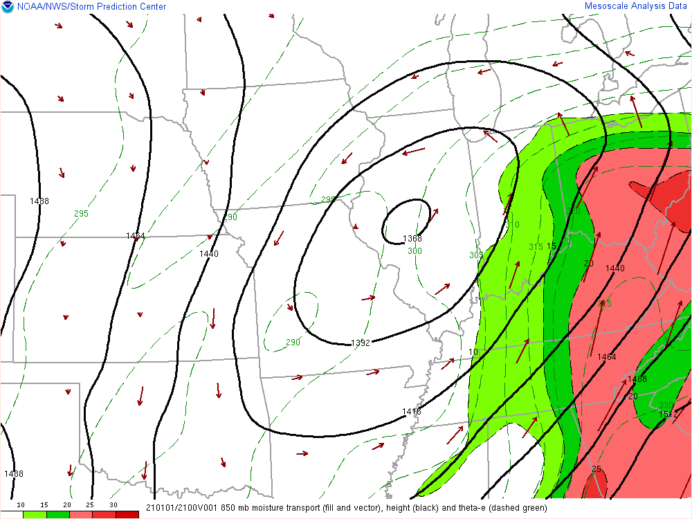
| Figure 16: 850mb moisture/warm air transport (fill and vector) at 1 pm ET Jan 1st, 2021. SPC Mesoanalysis Archive | Figure 17: 850mb moisture/warm air transport (fill and vector) at 4 pm ET Jan 1st, 2021. SPC Mesoanalysis Archive | Figure 18: 850mb moisture/warm air transport (fill and vector) at 7 pm ET Jan 1st, 2021. SPC Mesoanalysis Archive |
 |
 |
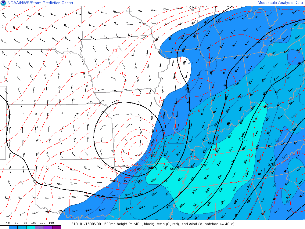 |
| Figure 19: Near surface temperatures around freezing (purple contour), above freezing in red (below in blue). Surface temperatures rising with daytime heating at 4 pm ET Jan 1st, 2021. SPC Mesoanalysis Archive | Figure 20: Near surface temperatures around freezing (purple contour), above freezing in red (below in blue). Surface temperatures rising with daytime heating at 6 pm ET Jan 1st, 2021. SPC Mesoanalysis Archive | Figure 21: Closed Low at 500mb at 1 pm ET Jan 1st, 2021. Fill is wind speed. Black lines are heights. SPC Mesoanalysis Archive |
 |
 |
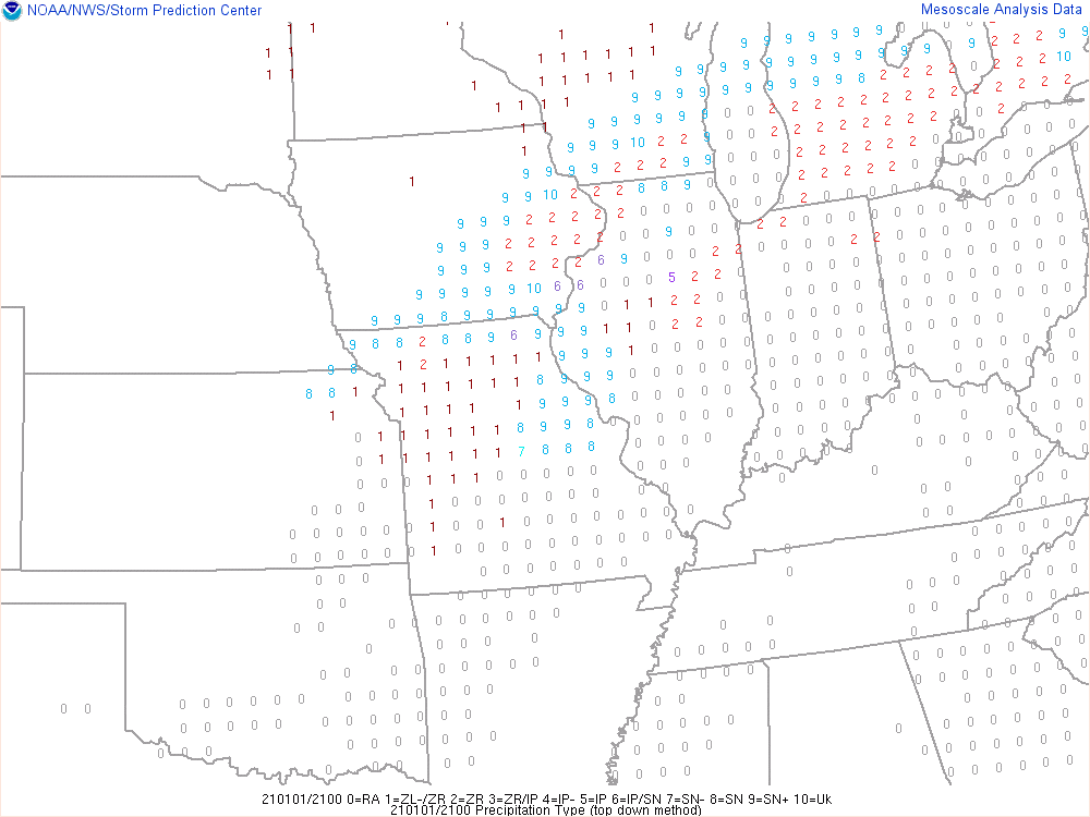 |
| Figure 22: Closed Low at 500mb at 7 pm ET Jan 1st, 2021. Fill is wind speed. Black lines are heights. SPC Mesoanalysis Archive | Figure 23: Weather Depiction at 1 pm ET Jan 1st, 2021. The numbers all represent weather types. Rain (1), Freezing Rain (light 1, moderate 2), Sleet (5), snow (9), and Unknown (10). SPC Mesoanalysis Archive | Figure 24: Weather Depiction at 7 pm ET Jan 1st, 2021. The numbers all represent weather types. Rain (1), Freezing Rain (light 1, moderate 2), Sleet (5), snow (9), and Unknown (10). SPC Mesoanalysis Archive |
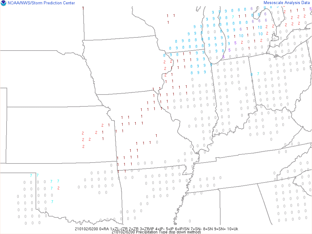
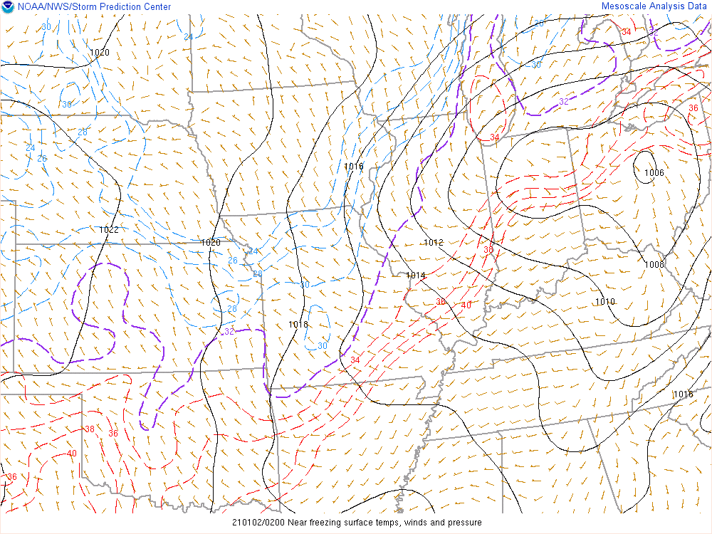
The surface low shifts even further northeastward during the evening hours, forcing the warm air and moisture transport aloft with it. The colder air aloft combined with colder surface temperatures (loss of daytime heating) caused a transition to light/moderate snow in the northwest as the back edge of the system moved in. Visibilities dropped to 1/2 mile at times during the moderate snow. By midnight, some areas (LaPorte, St. Joseph Counties in Indiana, and Berrien County, MI) saw up to 1 to 3 inches of snow, while others saw either patchy drizzle/freezing drizzle and flurries.
 |
 |
|
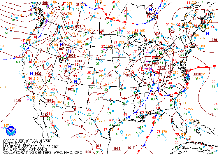
| Figure 25: At 10 pm ET Jan 1st, 2021. Surface low impacting our forecast area. WPC Surface Analysis Archive. | Figure 26: Weather Depiction at 9 pm ET Jan 1st, 2021. The numbers all represent weather types. Rain (1), Freezing Rain (light 1, moderate 2), Sleet (5), snow (7 light, 8 moderate, 9 heavy), and Unknown (10). SPC Mesoanalysis Archive | Figure 27: Weather Depiction at 10 pm ET Jan 1st, 2021. The numbers all represent weather types. Rain (1), Freezing Rain (light 1, moderate 2), Sleet (5), snow (7 light, 8 moderate, 9 heavy), and Unknown (10). SPC Mesoanalysis Archive |
 |
 |
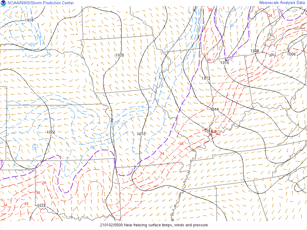 |
| Figure 28: Near surface temperatures around freezing (purple contour), above freezing in red (below in blue). 9 pm ET Jan 1st, 2021. SPC Mesoanalysis Archive | Figure 29: Near surface temperatures around freezing (purple contour), above freezing in red (below in blue). 11 pm ET Jan 1st, 2021. SPC Mesoanalysis Archive | Figure 30: Near surface temperatures around freezing (purple contour), above freezing in red (below in blue). 12 am ET Jan 2nd, 2021 SPC Mesoanalysis Archive |
 |
Media use of NWS Web News Stories is encouraged! Please acknowledge the NWS as the source of any news information accessed from this site. |
|

