Overview
A winter storm impacted northern Indiana, southern Lower Michigan, and northwest Ohio from late Saturday afternoon (January 30th) into the day Sunday (January 31st). The heaviest snow fell from late Saturday evening into early Sunday morning. The heaviest snowfall accumulations were noted roughly along and south of US 30 corridor where reports of 5 to 9 inches of snowfall were received. Lesser snow accumulations of 1 to 3 inches were reported across extreme northeast Indiana into south central Lower Michigan. Precipitation mixed with and changed over to sleet for a time south of US 24 late Saturday evening. This mixed precipitation resulted in some slightly lower storm total snow accumulations across these locations. East winds were strong during this event, gusting to 25 to 35 mph at times. The combination of moderate to heavy snow and these strong wind gusts led to significantly reduced visibilities at times.
Snow/Ice
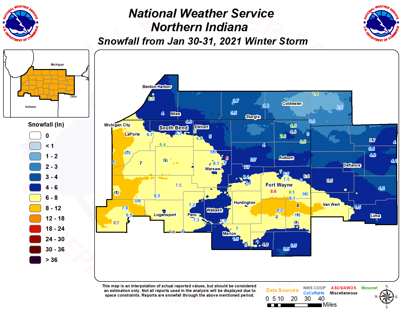
The map below represents an approximation of storm total snowfall. This map is not meant to be an exact depiction of the snowfall distribution, but to serve as a general overview. The National Weather Service Northern Indiana would like to thank the public, trained spotters, emergency management, amateur radio operators, and CoCoRaHS observers for excellent storm reports during and after this event!
Photos & Video
 |
 |
 |
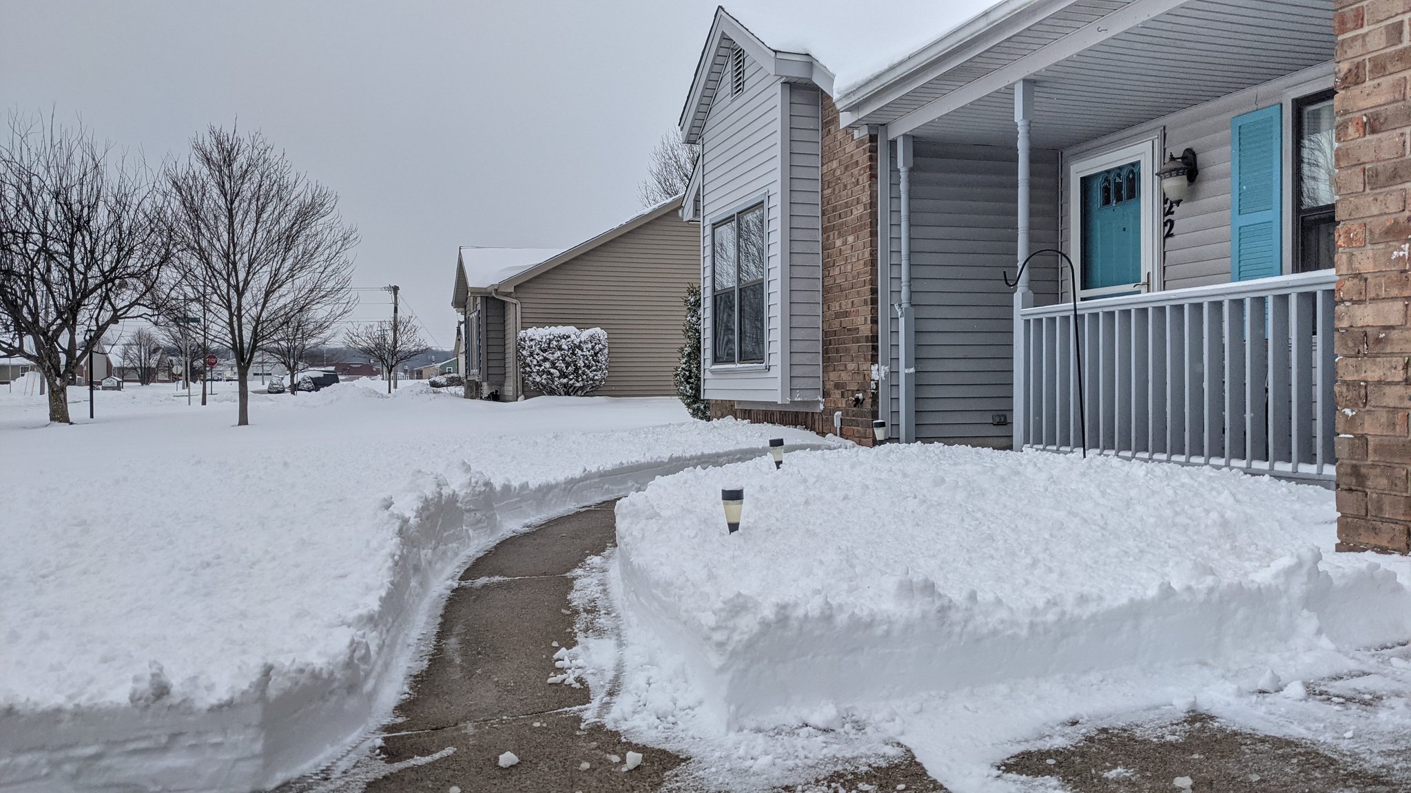 |
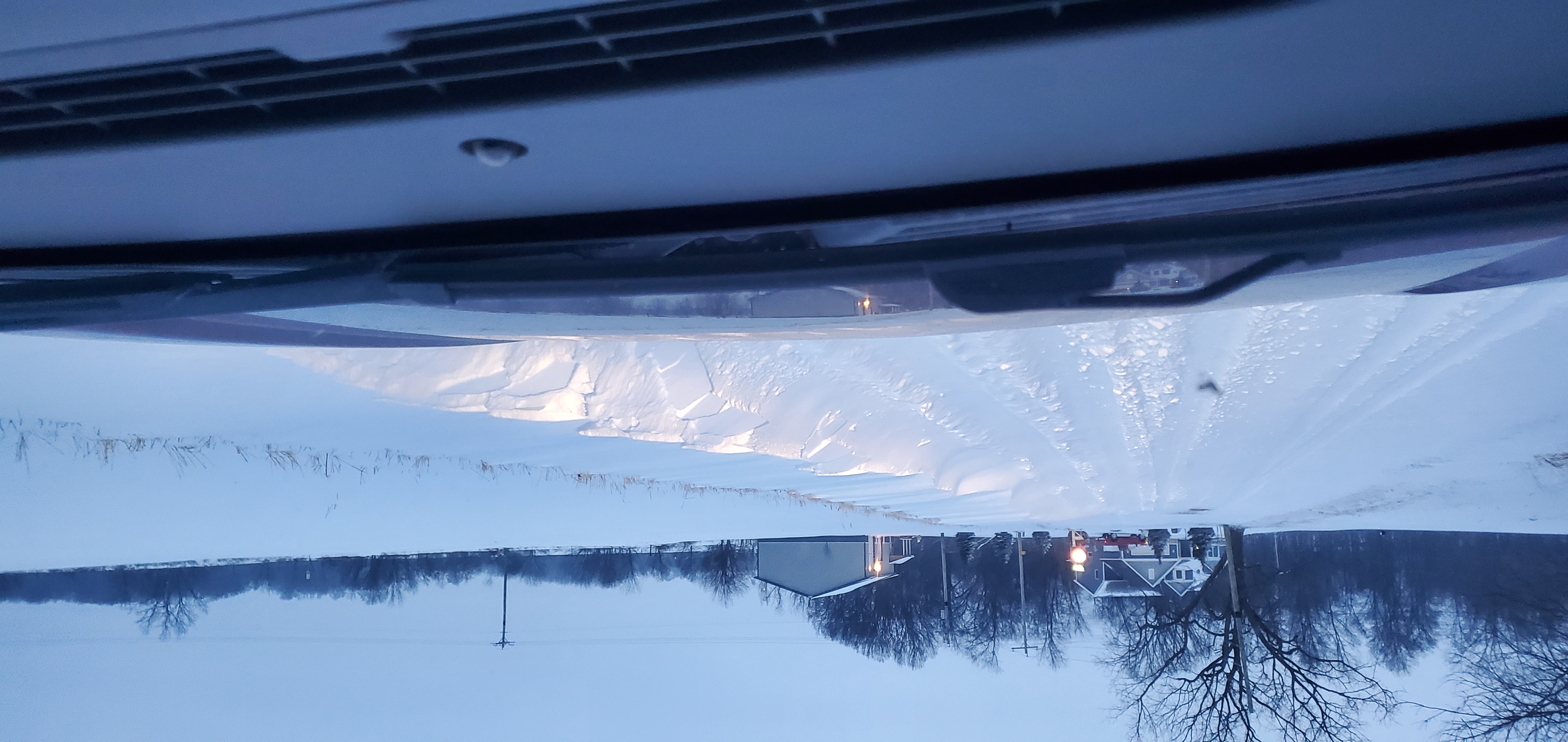
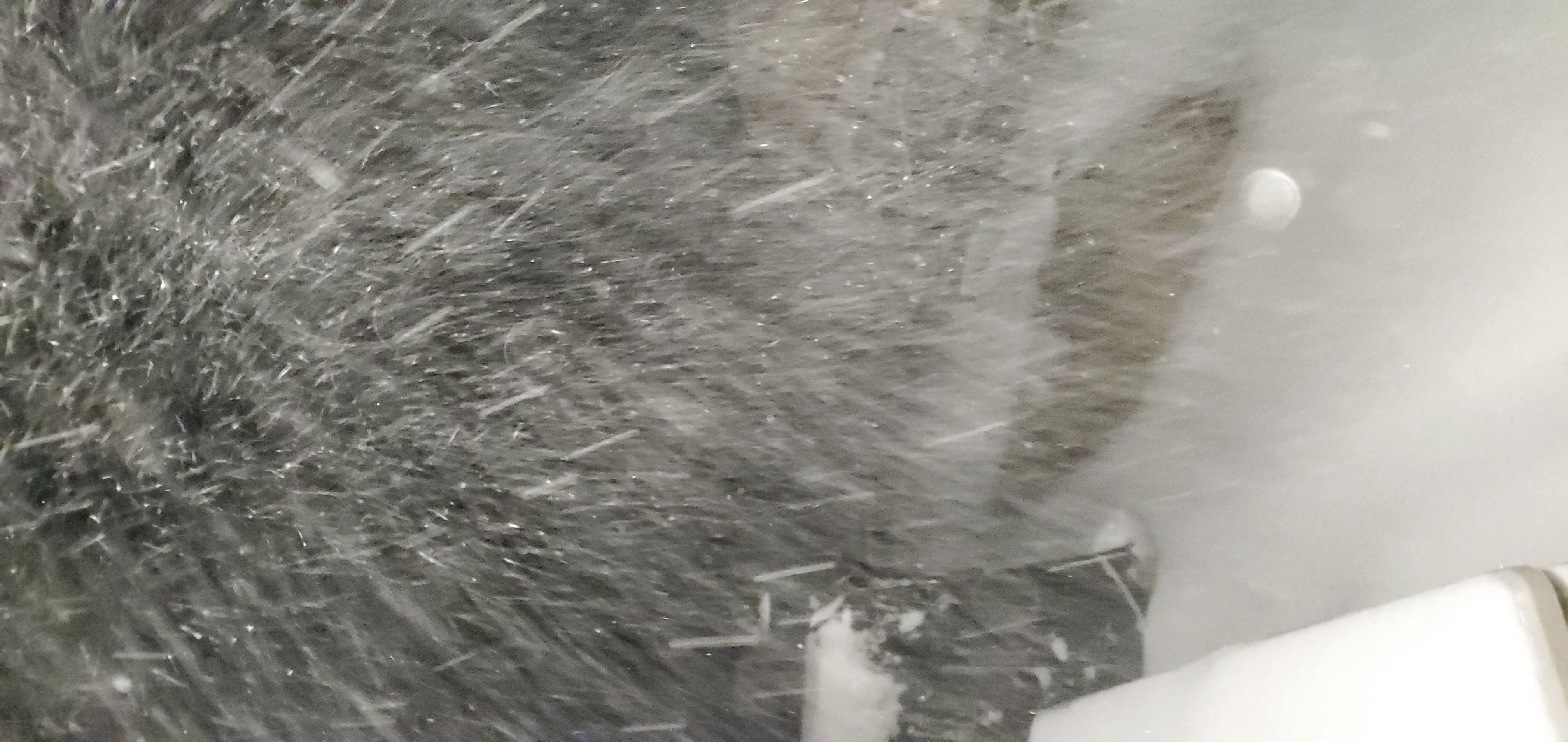
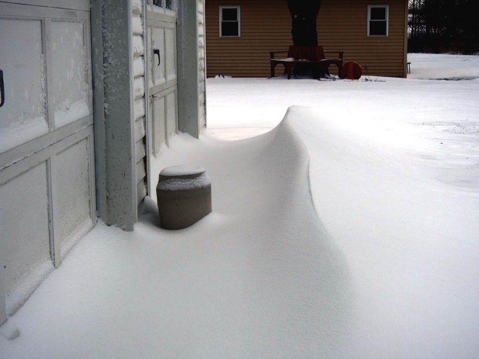
| Heavy snow just south of North Webster, IN. Photo courtesy of Todd Holsten. | Heavy snow occurring just south of North Webster, IN. Photo courtesy of Todd Holsten. | Large snow drifts near Story Lake in NE Indiana. Photo courtesy of Sharon Sheron. | Heavy snow in Bluffton, IN. Photo courtesy of Matthew Hartman. |
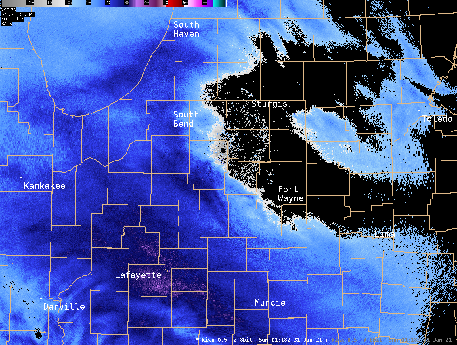
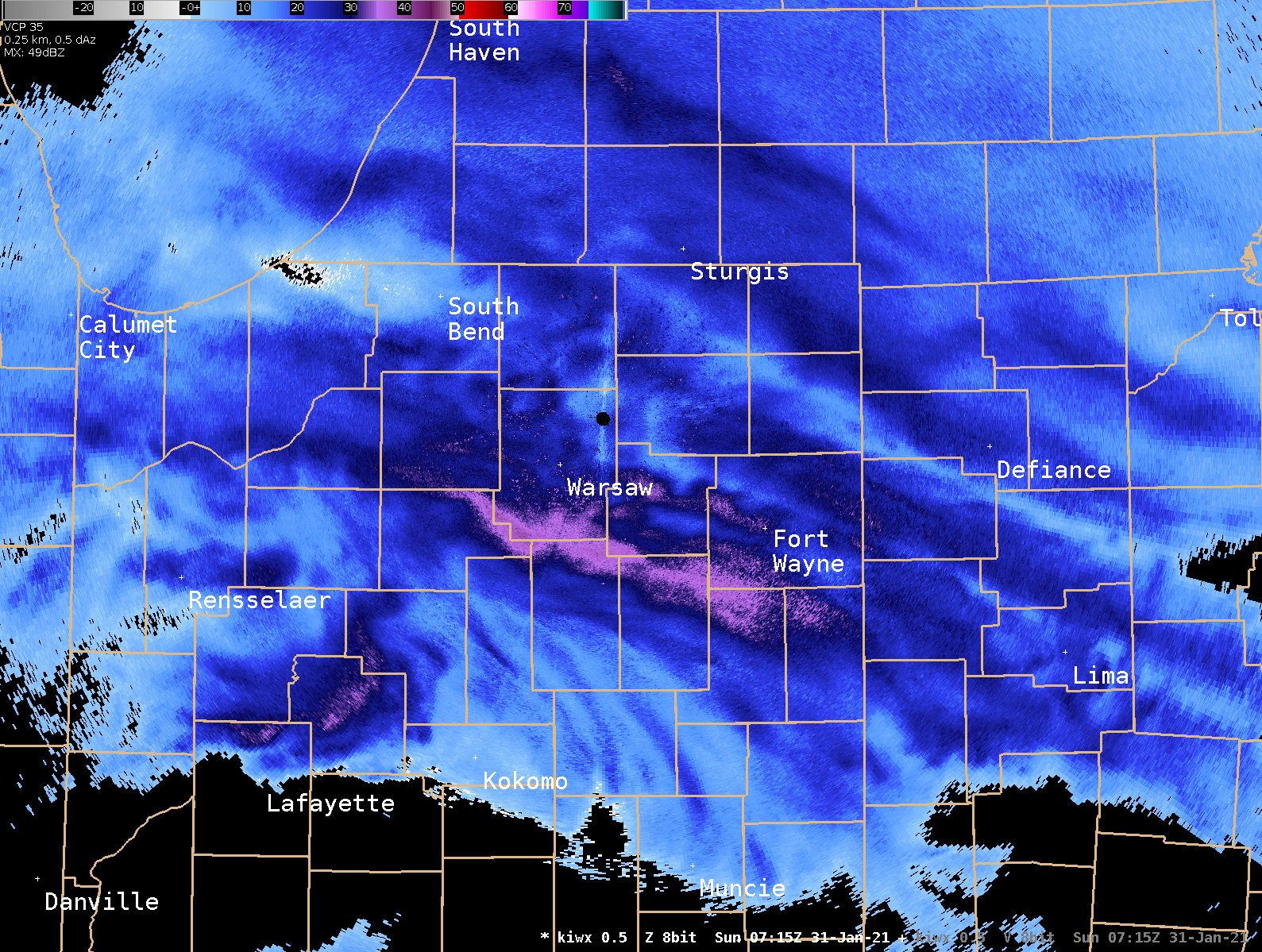
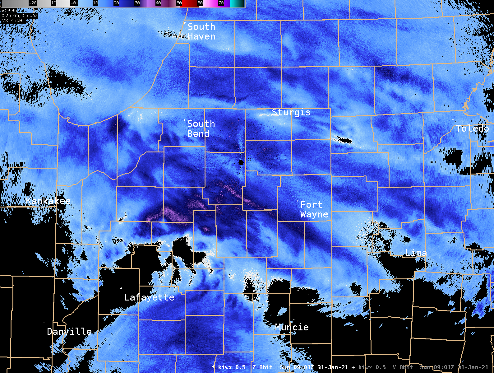
Radar
Snow overspread the area from southwest to northeast during the evening hours Saturday night. Areas across northwest Indiana into southwest Lower Michigan were much quicker to moisten the lower and middle levels of the atmosphere while areas further east had a slower onset time of the snow due to dry air lingering for a longer period. By late evening and especially into the overnight hours Saturday night, smaller scale snow bands produced periods of very heavy snow, especially along and south of US 30. A southerly low level jet with this system allowed just enough low level warm air northward to result in a mix of sleet and snow south of US 24.
 |
 |
 |
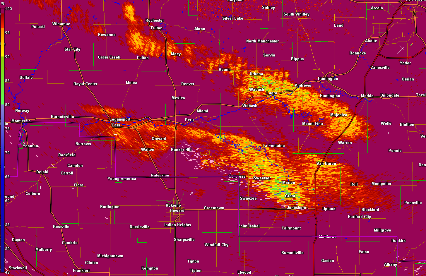 |
| KIWX 0.5 base reflectivity from ~ 815 PM to 9:40 PM EST 1/30/21. Snow (some sleet) overspreads the area, but dry air initially allows for later onset time across NE Indiana/S. Central Lower MI. | KIWX 0.5 base reflectivity from ~ 215 AM to 3:40 AM EST 1/31/21. Note the intense mesobanding (darker blues/purples) that lift south to north affecting Huntington/Fort Wayne IN areas. | KIWX 0.5 base reflectivity from ~ 400 AM to 515 AM EST 1/31/21. Bands of heavy snow continued into the early morning hours of Sunday, especially along and south of US 30. | KIWX 0.5 deg Correlation Coefficient (CC). Dual pol radar products gave some indication of melting hydrometeors aloft that allowed precip to transition to a period of sleet/snow. This mix appears to have cut down on snow totals across portions of these areas. |
Storm Reports
PRELIMINARY LOCAL STORM REPORT...SUMMARY
NATIONAL WEATHER SERVICE NORTHERN INDIANA
756 PM EST SUN JAN 31 2021

..TIME...   ...EVENT...      ...CITY LOCATION...     ...LAT.LON...
..DATE...   ....MAG....      ..COUNTY LOCATION..ST.. ...SOURCE....
            ..REMARKS..

0745 PM     SNOW             WILLSHIRE               40.75N 84.79W
01/31/2021  M6.0 INCH        VAN WERT           OH   EMERGENCY MNGR

            STORM TOTAL SNOWFALL.

0745 PM     HEAVY SNOW       VAN WERT                40.87N 84.58W
01/31/2021  M7.8 INCH        VAN WERT           OH   EMERGENCY MNGR

            STORM TOTAL SNOWFALL.

0700 PM     HEAVY SNOW       2 ENE NINE MILE         40.99N 85.18W
01/31/2021  M8.5 INCH        ALLEN              IN   OFFICIAL NWS OBS

            CORRECTION TO PREVIOUS SNOWFALL REPORT.
            STORM TOTAL SNOWFALL THROUGH 7 PM OF 8.5
            INCHES.

0700 PM     SNOW             1 SSE ROSELAND          41.71N 86.25W
01/31/2021  M4.7 INCH        ST. JOSEPH         IN   OFFICIAL NWS OBS

            STORM TOTAL SNOWFALL.

0600 PM     HEAVY SNOW       1 NNE WELLS             40.75N 86.10W
01/31/2021  M7.5 INCH        MIAMI              IN   EMERGENCY MNGR

            CORRECTION FOR LOCATION OF HEAVY SNOW. STORM
            TOTAL SNOWFALL.

0515 PM     SNOW             1 N NAPOLEON            41.41N 84.12W
01/31/2021  M6.0 INCH        HENRY              OH   EMERGENCY MNGR

            STORM TOTAL SNOWFALL.

0500 PM     SNOW             1 N OTTAWA              41.04N 84.04W
01/31/2021  M4.3 INCH        PUTNAM             OH   TRAINED SPOTTER

            STORM TOTAL SNOW. STILL SNOWING LIGHTLY.

0500 PM     SNOW             2 WSW LA PORTE          41.60N 86.75W
01/31/2021  M5.5 INCH        LA PORTE           IN   TRAINED SPOTTER

            STORM TOTAL SNOWFALL.

0430 PM     HEAVY SNOW       MARKLE                  40.83N 85.34W
01/31/2021  E8.0 INCH        HUNTINGTON         IN   PUBLIC

            STORM TOTAL SNOWFALL.

0430 PM     HEAVY SNOW       2 ESE HELMER            41.52N 85.13W
01/31/2021  M6.0 INCH        DE KALB            IN   CO-OP OBSERVER

            STOM TOTAL SNOWFALL.

0424 PM     HEAVY SNOW       GEORGETOWN              41.73N 86.23W
01/31/2021  M6.1 INCH        ST. JOSEPH         IN   PUBLIC

            .

0415 PM     SNOW             GAS CITY                40.49N 85.61W
01/31/2021  M5.0 INCH        GRANT              IN   PUBLIC

            .

0412 PM     HEAVY SNOW       1 N BLUFFTON            40.76N 85.17W
01/31/2021  M7.9 INCH        WELLS              IN   PUBLIC

            .

0300 PM     HEAVY SNOW       COLUMBIA CITY           41.16N 85.48W
01/31/2021  M7.7 INCH        WHITLEY            IN   PUBLIC

            .

0240 PM     HEAVY SNOW       5 N NEW HAVEN           41.14N 85.02W
01/31/2021  E7.6 INCH        ALLEN              IN   AMATEUR RADIO

            STORM TOTAL SO FAR.

0230 PM     HEAVY SNOW       2 NE WANATAH            41.45N 86.86W
01/31/2021  M10.0 INCH       LA PORTE           IN   PUBLIC

            STORM TOTAL SO FAR.

0200 PM     HEAVY SNOW       AUBURN                  41.36N 85.06W
01/31/2021  M6.0 INCH        DE KALB            IN   PUBLIC

            STORM TOTAL SO FAR.

0149 PM     HEAVY SNOW       MONROEVILLE             40.98N 84.87W
01/31/2021  M6.3 INCH        ALLEN              IN   TRAINED SPOTTER

            SNOW TOTAL SO FAR.

0130 PM     HEAVY SNOW       BLUFFTON                40.74N 85.17W
01/31/2021  M9.1 INCH        WELLS              IN   TRAINED SPOTTER

            UPDATE STORM TOTAL.

0110 PM     SNOW             STURGIS                 41.80N 85.42W
01/31/2021  M3.8 INCH        ST. JOSEPH         MI   TRAINED SPOTTER

            .

0110 PM     SNOW             2 N STURGIS             41.83N 85.42W
01/31/2021  M3.8 INCH        ST. JOSEPH         MI   TRAINED SPOTTER

            STORM TOTAL SO FAR.

0100 PM     SNOW             1 ESE SPRINGVILLE       41.68N 86.72W
01/31/2021  M4.5 INCH        LA PORTE           IN   TRAINED SPOTTER

            STORM TOTAL SO FAR.

1230 PM     SNOW             WATERFORD               41.67N 86.85W
01/31/2021  M5.3 INCH        LA PORTE           IN   PUBLIC

            STORM TOTAL SO FAR.

1200 PM     HEAVY SNOW       4 SW COLUMBIA CITY      41.12N 85.54W
01/31/2021  M8.5 INCH        WHITLEY            IN   TRAINED SPOTTER

            STORM TOTAL SO FAR.

1109 AM     HEAVY SNOW       1 E HUNTINGTON          40.88N 85.45W
01/31/2021  M8.1 INCH        HUNTINGTON         IN   EMERGENCY MNGR

            .

1100 AM     SNOW             COLUMBUS GROVE          40.92N 84.06W
01/31/2021  M3.5 INCH        PUTNAM             OH   TRAINED SPOTTER

            STORM TOTAL SO FAR.

1030 AM     HEAVY SNOW       4 S LEO-CEDARVILLE      41.16N 85.02W
01/31/2021  M6.1 INCH        ALLEN              IN   TRAINED SPOTTER

            STORM TOTAL SO FAR.

1030 AM     HEAVY SNOW       KNOX                    41.29N 86.62W
01/31/2021  M8.0 INCH        STARKE             IN   PUBLIC

            STORM TOTAL SO FAR.

1014 AM     SNOW             3 NW KLINGER LAKE       41.84N 85.59W
01/31/2021  M3.5 INCH        ST. JOSEPH         MI   PUBLIC

            .

1000 AM     HEAVY SNOW       1 SE MONTICELLO         40.74N 86.75W
01/31/2021  M8.0 INCH        WHITE              IN   PUBLIC

            STORM TOTAL SO FAR.

1000 AM     HEAVY SNOW       2 W HANNA               41.41N 86.82W
01/31/2021  M7.5 INCH        LA PORTE           IN   COCORAHS

            .

0950 AM     SNOW             MARION                  40.55N 85.67W
01/31/2021  M5.9 INCH        GRANT              IN   PUBLIC

            STORM TOTAL SO FAR.

0930 AM     HEAVY SNOW       BREMEN                  41.45N 86.15W
01/31/2021  M6.0 INCH        MARSHALL           IN   PUBLIC

            STORM TOTAL SO FAR.

0930 AM     HEAVY SNOW       .25 SW HUNTINGTON       40.88N 85.51W
01/31/2021  M8.3 INCH        HUNTINGTON         IN   TRAINED SPOTTER

            STORM TOTAL SO FAR.

0900 AM     HEAVY SNOW       1 N ROLLING HILLS       41.04N 85.27W
01/31/2021  M7.3 INCH        ALLEN              IN   BROADCAST MEDIA

            UPDATES PREVIOUS HEAVY SNOW REPORT FROM 1 N
            ROLLING HILLS. STORM TOTAL SO FAR.

0900 AM     HEAVY SNOW       2 ESE HUNTERTOWN        41.22N 85.13W
01/31/2021  M6.0 INCH        ALLEN              IN   COCORAHS

            .

0900 AM     SNOW             JONESBORO               40.48N 85.63W
01/31/2021  M5.0 INCH        GRANT              IN   PUBLIC

            STORM TOTAL SO FAR.

0900 AM     SNOW             PERU                    40.75N 86.07W
01/31/2021  M5.5 INCH        MIAMI              IN   PUBLIC

            STORM TOTAL SO FAR.

0900 AM     HEAVY SNOW       FAIR PLAIN              42.08N 86.45W
01/31/2021  M8.0 INCH        BERRIEN            MI   TRAINED SPOTTER

            STORM TOTAL SO FAR.

0900 AM     SNOW             BUTLER                  41.43N 84.87W
01/31/2021  E3.0 INCH        DE KALB            IN   PUBLIC

            ESTIMATED TOTAL SNOW SO FAR.

0830 AM     SNOW             VAN BUREN               40.62N 85.51W
01/31/2021  M5.6 INCH        GRANT              IN   PUBLIC

            STORM TOTAL SO FAR.

0806 AM     HEAVY SNOW       LOGANSPORT              40.75N 86.36W
01/31/2021  M8.0 INCH        CASS               IN   COCORAHS

            .

0805 AM     HEAVY SNOW       1 NNE WINONA LAKE       41.24N 85.81W
01/31/2021  M6.8 INCH        KOSCIUSKO          IN   NWS EMPLOYEE

            .

0800 AM     HEAVY SNOW       ROCHESTER               41.06N 86.20W
01/31/2021  M7.0 INCH        FULTON             IN   COCORAHS

            .

0800 AM     SNOW             3 WSW GOSHEN            41.56N 85.89W
01/31/2021  M4.4 INCH        ELKHART            IN   COCORAHS

            .

0800 AM     SNOW             LIMA                    40.74N 84.11W
01/31/2021  M4.0 INCH        ALLEN              OH   PUBLIC

            STORM TOTAL SO FAR.

0800 AM     SNOW             2 NW MARION             40.57N 85.69W
01/31/2021  M4.8 INCH        GRANT              IN   COCORAHS

            .

0800 AM     SNOW             PORTLAND                40.43N 84.98W
01/31/2021  M3.0 INCH        JAY                IN   COCORAHS

            .

0800 AM     HEAVY SNOW       NEW BUFFALO             41.79N 86.75W
01/31/2021  M6.0 INCH        BERRIEN            MI   PUBLIC

            STORM TOTAL.

0800 AM     HEAVY SNOW       1 NW LA FONTAINE        40.68N 85.74W
01/31/2021  M6.5 INCH        WABASH             IN   COCORAHS

            .

0800 AM     SNOW             2 NNW TEEGARDEN         41.49N 86.39W
01/31/2021  M5.7 INCH        ST. JOSEPH         IN   COCORAHS

            .

0800 AM     HEAVY SNOW       MONTICELLO              40.75N 86.76W
01/31/2021  M6.5 INCH        WHITE              IN   COCORAHS

            .

0800 AM     SNOW             2 SE BRAILEY            41.53N 83.89W
01/31/2021  M2.5 INCH        FULTON             OH   COCORAHS

            .

0730 AM     SNOW             1 NW SOUTH BEND         41.69N 86.28W
01/31/2021  M5.3 INCH        ST. JOSEPH         IN   TRAINED SPOTTER

            STORM TOTAL SO FAR. SOME DRIFTS TO 8 INCHES.

0730 AM     SNOW             2 E SALEM CENTER        41.59N 85.11W
01/31/2021  M2.1 INCH        STEUBEN            IN   TRAINED SPOTTER

            .

0728 AM     SNOW             OTTAWA                  41.02N 84.04W
01/31/2021  M4.0 INCH        PUTNAM             OH   TRAINED SPOTTER

            .

0700 AM     HEAVY SNOW       HUNTINGTON              40.88N 85.49W
01/31/2021  M6.9 INCH        HUNTINGTON         IN   COCORAHS

            .

0700 AM     SNOW             SOUTH BEND              41.71N 86.25W
01/31/2021  M4.1 INCH        ST. JOSEPH         IN   OFFICIAL NWS OBS

            SNOW DEPTH 6 INCHES.

0700 AM     SNOW             2 NE THREE RIVERS       41.97N 85.61W
01/31/2021  M3.7 INCH        ST. JOSEPH         MI   COCORAHS

            .

0630 AM     SNOW             NAPPANEE                41.45N 85.99W
01/31/2021  M5.2 INCH        ELKHART            IN   TRAINED SPOTTER

            STORM TOTAL SO FAR.


&&

$$
Environment
A dynamic mid and upper level system tracked eastward from eastern Missouri and western Illinois Saturday night into Sunday. A strong low level jet developed downstream of this feature and moisture northward into the region. Some unstable conditions aloft developed as this upper level system approached, and this instability was one factor that allowed bands of more intense snow to develop late Saturday night. The heaviest storm total snow accumulations were across areas which experienced this instability aloft coupled with low and mid level frontogenesis forcing (see below). The low level jet allowed enough warm air to advect northward to produce some sleet south of Route 24 late Saturday evening into the early overnight hours before changing back to snow.
 |
 |
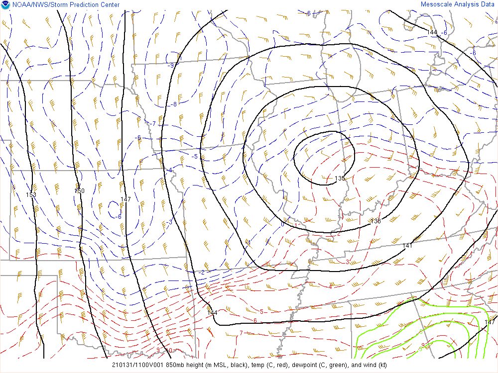 |
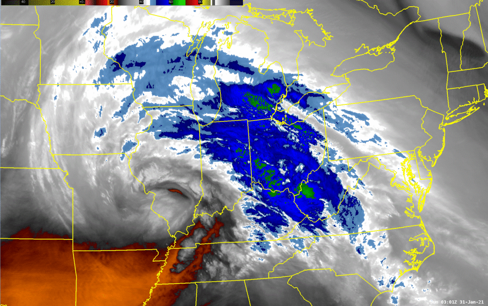
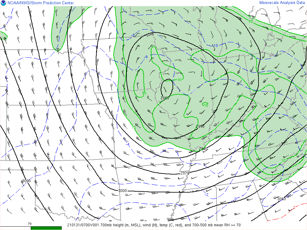
| Figure 1: GOES Band 9 Mid Tropospheric Water Vapor loop from 10pm 1/30/21 to 3am 1/31/21. An intense upper level low lifted northeast across the region bring the periods of heavy snow. | Figure 2: RAP 1-hr forecast of 700 mb heights and temperatures valid at 2am 1/31/21. The mid level system slowly tracked east across northern/central Indiana into Sunday prolonging the snow | Figure 3: RAP 1-hr forecast of 850 mb winds, heights, and temperatures. Note the very strong transition from warm air to cold air across Indiana as a low level jet helped increase the forcing for precipitation |
 |
 |
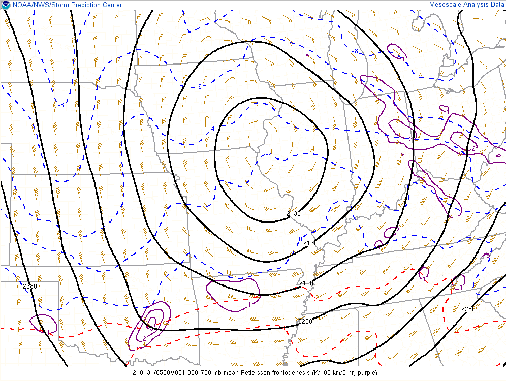 |
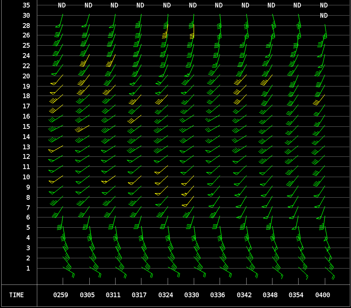
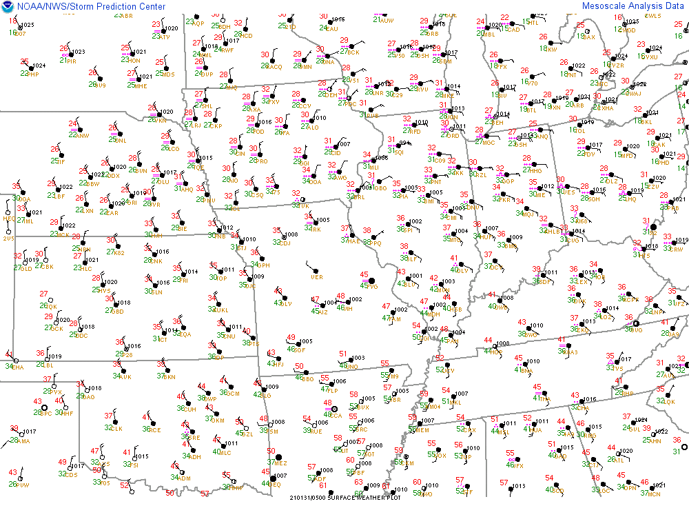
| Figure 4: VAD wind profile from KIND radar from between 10pm and 11pm EST 1/30/21. South-southeast winds of 35 to 45 mph brought warmer air northward and led to a wintry mix of sleet and snow Saturday evening south of US 24. | Figure 5: Surface observations from midnight 1/31/21 indicating surface low pressure with the system across west central Illinois. Stiff east winds to the east of this system resulted in some blowing and drifting snow. | Figure 6: RAP 850-700 mb mean frontogenesis (purple) valid at midnight EST 1/31/21. Low and mid level frontogenesis forcing helped produce the narrow bands of very heavy snowfall with 1 to 2 inch per hour snowfall rates. |
 |
 |
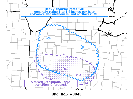 |
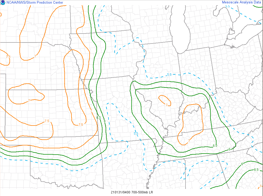
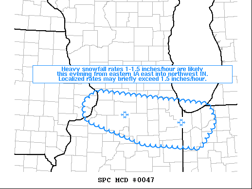
| Figure 7: RAP mid level lapse rates valid at 11pm EST 1/30/21. A pocket of steeper mid level lapse rates advected into central Indiana Saturday night. This resulted in a few instances of thunder. The instability also contributed to the banded nature of the snow across the area. | Figure 8: SPC mesoscale discussion for heavy snow potential into northwest Indiana (issued at 723 PM EST). A link to the full text product available here. | Figure 9: SPC mesoscale discussion for heavy snow (issued at 1039 PM EST). A link to the full text product available here. |
 |
Media use of NWS Web News Stories is encouraged! Please acknowledge the NWS as the source of any news information accessed from this site. |
|

