Overview
A dangerous arctic air mass overspread the region Monday night into Tuesday and affected the area through Thursday. Wind chills as cold as 40 below to 50 below zero were reported during this event. Daily temperature records were set at both Fort Wayne and South Bend.
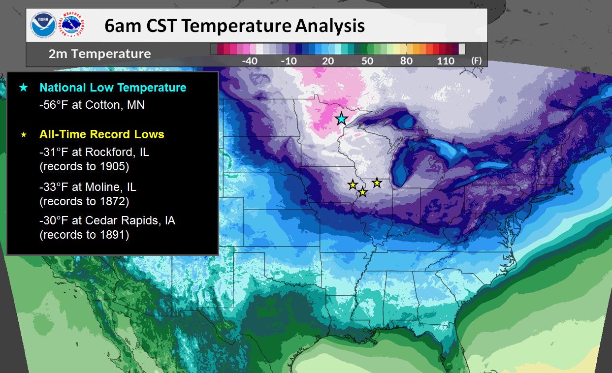
Below is a map courtesy of the Weather Prediction Center (WPC) of temperatures from the early morning hours of January 31st. Some locations across Illinois and Iowa set all time low temperature records. South Bend, Indiana approached near record cold levels. Note from the map just how expansive this dangerous and bitterly cold air was across the region.
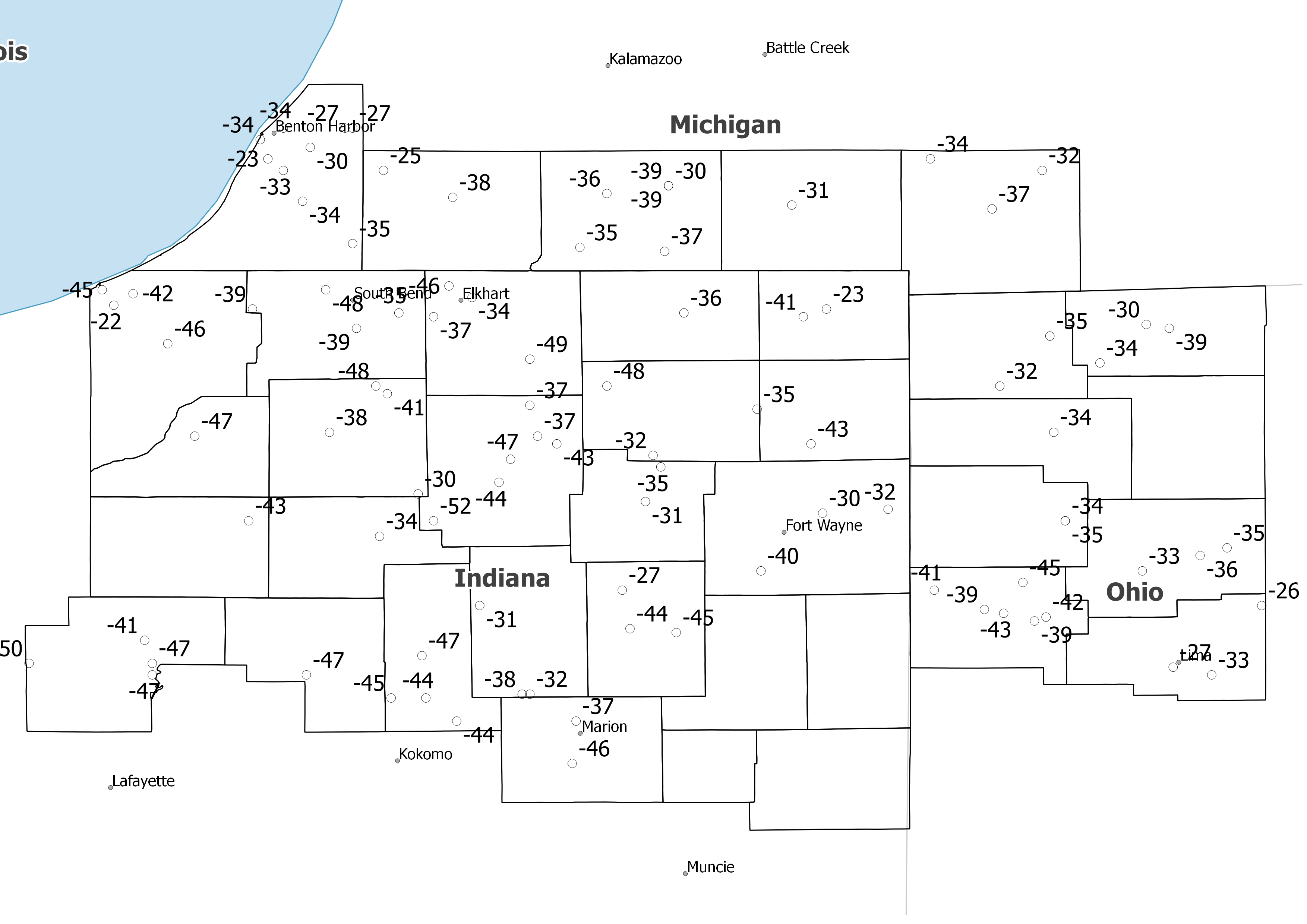
Map of Minimum Wind Chills
Map of minimum wind chills from January 29 to January 31st
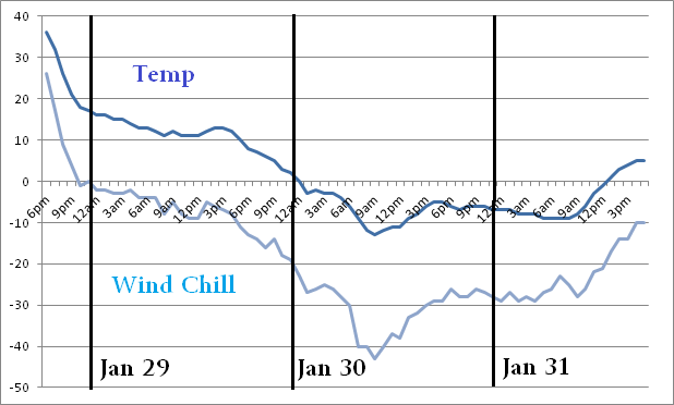
Fort Wayne/South Bend Temps/Wind Chills
Below are the temperature and wind chill trends during the event.
South Bend:

Fort Wayne
Coldest Event Wind Chills
Public Information Statement
National Weather Service Northern Indiana
426 PM EST Thu Jan 31 2019

...LOWEST WIND CHILL REPORTS PAST 72 HOURS...

Location                     Temp      Time/Date       Lat/Lon

...Indiana...

...Allen County...
Fort Wayne International Ap  -40 F     0754 AM 01/30   40.98N/85.20W
Woodburn                     -32 F     0701 AM 01/30   41.14N/84.86W
4 N New Haven                -30 F     0800 AM 01/30   41.13N/85.03W

...Cass County...
Logansport/cass Cnty Ap      -47 F     0735 AM 01/30   40.71N/86.37W

...De Kalb County...
3 E Saint Johns              -43 F     0755 AM 01/30   41.31N/85.06W

...Elkhart County...
Goshen Municipal Airport     -49 F     0853 AM 01/30   41.53N/85.79W
Elkhart Municipal Airport    -46 F     0752 AM 01/30   41.72N/86.00W
1 WNW Jimtown                -37 F     0758 AM 01/30   41.64N/86.04W
1 ENE Elkhart                -34 F     0734 AM 01/30   41.69N/85.94W
2 SW Simonton Lake           -34 F     0459 PM 01/30   41.72N/86.00W

...Fulton County...
Fulton County Airport        -34 F     0555 AM 01/30   41.07N/86.18W

...Grant County...
Grant County Municipal Apt   -46 F     0755 AM 01/30   40.48N/85.68W
2 N Marion                   -37 F     0747 AM 01/30   40.59N/85.67W

...Huntington County...
3 NE Majenica                -45 F     0913 AM 01/30   40.82N/85.41W
3 SSW Huntington             -44 F     0758 AM 01/30   40.83N/85.53W

...Kosciusko County...
1 SW Sevastopol              -52 F     1149 AM 01/30   41.11N/86.04W
Warsaw Municipal Airport     -47 F     0855 AM 01/30   41.27N/85.84W
2 SW Warsaw                  -44 F     0945 AM 01/30   41.21N/85.87W
James Lake                   -43 F     1023 AM 01/30   41.31N/85.72W
Tippecanoe Lake              -37 F     0730 AM 01/30   41.33N/85.77W
2 WSW Syracuse               -37 F     1209 PM 01/30   41.41N/85.79W

...La Porte County...
La Porte                     -46 F     0955 AM 01/30   41.57N/86.73W
1 W Michigan City            -45 F     0750 AM 01/30   41.71N/86.90W
Michigan City                -42 F     0815 AM 01/30   41.70N/86.82W

...Lagrange County...
1 ENE Lagrange               -36 F     0730 AM 01/30   41.65N/85.39W

...Marshall County...
2 WNW Bremen                 -48 F     1005 AM 01/30   41.46N/86.19W
Bremen                       -41 F     0739 AM 01/30   41.44N/86.16W
Plymouth                     -38 F     1148 AM 01/30   41.34N/86.31W
2 W Mentone                  -30 F     1248 PM 01/30   41.18N/86.08W

...Miami County...
Peru                         -47 F     0925 AM 01/30   40.76N/86.07W
1 SSW Grissom Afb            -45 F     0756 AM 01/30   40.65N/86.15W
2 E Bunker Hill              -44 F     0735 AM 01/30   40.65N/86.06W
3 W Amboy                    -44 F     0900 AM 01/30   40.59N/85.98W

...Noble County...
Ligonier                     -48 F     1009 AM 01/30   41.46N/85.59W
3 NE Avilla                  -35 F     0740 AM 01/30   41.40N/85.20W
1 E Big Lake                 -32 F     0745 AM 01/30   41.28N/85.47W

...Pulaski County...
3 ENE Vanmeter Park          -43 F     1200 PM 01/30   41.11N/86.52W

...St. Joseph County...
South Bend International Ap  -48 F     1009 AM 01/30   41.71N/86.32W
Gulivoire Park               -39 F     0800 AM 01/30   41.61N/86.24W
2 S New Carlisle             -39 F     1233 PM 01/30   41.66N/86.51W
2 ESE Mishawaka              -35 F     0802 AM 01/30   41.65N/86.13W

...Starke County...
2 ESE Brems                  -47 F     1055 AM 01/30   41.33N/86.66W

...Steuben County...
Tri-state Steuben County Air -41 F     0635 AM 01/30   41.64N/85.08W

...Wabash County...
Somerset                     -38 F     0711 AM 01/30   40.66N/85.81W
2 ESE Somerset               -32 F     0728 AM 01/30   40.66N/85.79W
1 SSE Roann                  -31 F     0731 AM 01/30   40.89N/85.92W

...White County...
3 WSW Wolcott                -50 F     0925 AM 01/30   40.74N/87.09W
Monticello                   -47 F     0910 AM 01/30   40.74N/86.77W
White County Arpt.           -47 F     0835 AM 01/30   40.71N/86.77W
1 WNW Indiana Beach          -41 F     0735 AM 01/30   40.80N/86.79W

...Whitley County...
2 NE Tri-Lakes               -35 F     0701 AM 01/30   41.25N/85.45W
Columbia City                -31 F     0631 AM 01/30   41.16N/85.49W

...Michigan...

...Berrien County...
3 WSW Sodus                  -38 F     0900 AM 01/31   42.02N/86.43W
Saint Joseph                 -36 F     1030 AM 01/31   42.10N/86.49W
Niles                        -35 F     1104 AM 01/30   41.83N/86.25W
1 WSW Spinks Corners         -35 F     0900 AM 01/31   42.08N/86.36W
Southwest Michigan Regional  -34 F     0753 AM 01/30   42.13N/86.43W
2 WSW Berrien Springs        -34 F     1200 PM 01/30   41.94N/86.38W
3 ENE Spinks Corners         -34 F     0900 AM 01/31   42.13N/86.27W
Watervliet                   -34 F     0900 AM 01/31   42.13N/86.25W

...Branch County...
1 NNW Batavia                -36 F     0600 AM 01/31   41.93N/85.11W

...Cass County...
2 E La Grange                -38 F     1200 PM 01/30   41.95N/85.99W
2 SE Sandy Beach             -35 F     0900 AM 01/31   42.02N/86.17W

...Hillsdale County...
Hillsdale Municipal Airport  -37 F     0716 AM 01/30   41.92N/84.59W
Litchfield                   -34 F     0804 AM 01/30   42.05N/84.75W
Jerome                       -32 F     0802 AM 01/30   42.02N/84.46W

...St. Joseph County...
Mendon                       -39 F     1200 PM 01/30   41.98N/85.43W
2 SE Mendon                  -39 F     1200 PM 01/30   41.98N/85.43W
Sturgis                      -37 F     0755 AM 01/30   41.81N/85.44W
Three Rivers Municipal Dr Ha -37 F     0855 AM 01/31   41.96N/85.59W
1 SSE Constantine            -36 F     0900 AM 01/31   41.82N/85.66W

...Ohio...

...Allen County...
Lima Allen County Airport    -33 F     0753 AM 01/30   40.71N/84.02W

...Defiance County...
Defiance Memorial Airport    -34 F     0653 AM 01/30   41.34N/84.43W

...Fulton County...
Fulton Cnty Ap               -39 F     0810 AM 01/30   41.61N/84.13W
Archbold                     -34 F     0739 AM 01/30   41.52N/84.31W
1 NE Tedrow                  -30 F     0754 AM 01/30   41.62N/84.19W

...Paulding County...
1 NW Oakwood                 -35 F     1115 AM 01/30   41.11N/84.40W

...Putnam County...
Ottawa                       -36 F     0739 AM 01/30   41.02N/84.05W
3 ENE Ottawa                 -35 F     0735 AM 01/30   41.04N/83.98W
Kalida                       -33 F     0802 AM 01/30   40.98N/84.20W

...Van Wert County...
3 E Cavett                   -45 F     1014 AM 01/30   40.95N/84.51W
1 ENE Van Wert               -43 F     1028 AM 01/30   40.87N/84.56W
Middle Point                 -42 F     1058 AM 01/30   40.86N/84.45W
2 WNW Convoy                 -41 F     1051 AM 01/30   40.93N/84.74W
1 WNW Van Wert               -39 F     0724 AM 01/30   40.88N/84.61W
1 W Middle Point             -39 F     0803 AM 01/30   40.85N/84.48W

...Williams County...
1 WSW Bryan                  -32 F     0802 AM 01/30   41.46N/84.57W
West Unity                   -35 F     0719 AM 01/30   41.59N/84.44W


Observations are collected from a variety of sources with varying
equipment and exposures. We thank all volunteer weather observers
for their dedication. Not all data listed are considered official.
Coldest Event Min Temps
Public Information Statement
National Weather Service Northern Indiana
458 PM EST Thu Jan 31 2019

...LOW TEMPERATURE REPORTS PAST 72 HOURS...

Location                     Temp      Time/Date       Lat/Lon

...Indiana...

...Adams County...
Decatur 1n                   -16 F     0700 AM 01/31   40.85N/84.93W

...Allen County...
Woodburn 3n                  -16 F     0700 AM 01/31   41.16N/84.85W
4 N New Haven                -15 F     1005 AM 01/30   41.13N/85.03W
Woodburn                     -14 F     1000 AM 01/30   41.14N/84.86W
Fort Wayne International Ap  -13 F     0854 AM 01/30   40.98N/85.20W

...Blackford County...
Hartford City 4ese           -15 F     0800 AM 01/31   40.44N/85.29W

...Cass County...
Young America                -18 F     0800 AM 01/31   40.57N/86.33W
Logansport/cass Cnty Ap      -17 F     1035 AM 01/30   40.71N/86.37W

...De Kalb County...
Garrett                      -17 F     0700 AM 01/31   41.34N/85.13W
3 E Saint Johns              -15 F     0655 AM 01/31   41.31N/85.06W

...Elkhart County...
1 WNW Jimtown                -20 F     0803 AM 01/31   41.64N/86.04W
Goshen Municipal Airport     -19 F     0853 AM 01/30   41.53N/85.79W
1 ENE Elkhart                -18 F     0821 AM 01/31   41.69N/85.94W
Elkhart Municipal Airport    -18 F     0750 AM 01/31   41.72N/86.00W
2 SW Simonton Lake           -13 F     0459 PM 01/30   41.72N/86.00W

...Grant County...
2 N Marion                   -17 F     0912 AM 01/30   40.59N/85.67W
Grant County Municipal Apt   -15 F     1255 PM 01/31   40.48N/85.68W
Marion 2n                    -10 F     0700 AM 01/31   40.58N/85.66W

...Huntington County...
Huntington                   -22 F     0630 AM 01/31   40.86N/85.50W
3 NE Majenica                -17 F     0953 AM 01/30   40.82N/85.41W
3 NW Huntington              -17 F     0910 AM 01/30   40.93N/85.55W
3 SSW Huntington             -15 F     0938 AM 01/30   40.83N/85.53W

...Kosciusko County...
1 SW Sevastopol              -24 F     0849 AM 01/30   41.11N/86.04W
Tippecanoe Lake              -20 F     0855 AM 01/30   41.33N/85.77W
James Lake                   -19 F     1028 AM 01/30   41.31N/85.72W
2 SW Warsaw                  -19 F     1001 AM 01/30   41.21N/85.87W
Warsaw Municipal Airport     -18 F     0935 AM 01/30   41.27N/85.84W
2 WSW Syracuse               -18 F     0904 AM 01/30   41.41N/85.79W
2 WSW Monoquet               -18 F     1000 AM 01/30   41.27N/85.89W

...La Porte County...
La Porte                     -25 F     0655 AM 01/31   41.57N/86.73W
1 SE La Porte                -23 F     0700 AM 01/31   41.59N/86.69W
1 W Michigan City            -21 F     0805 AM 01/31   41.71N/86.90W
1 WSW Waterford              -20 F     0731 AM 01/31   41.67N/86.87W
Michigan City                -18 F     0855 AM 01/31   41.70N/86.82W

...Lagrange County...
1 ENE Lagrange               -16 F     0826 AM 01/31   41.65N/85.39W

...Marshall County...
2 WNW Bremen                 -23 F     1025 AM 01/30   41.46N/86.19W
Bremen                       -20 F     1039 AM 01/30   41.44N/86.16W
Plymouth                     -18 F     0947 AM 01/30   41.34N/86.31W
2 W Mentone                  -17 F     0953 AM 01/30   41.18N/86.08W

...Miami County...
2 E Bunker Hill              -20 F     1000 AM 01/30   40.65N/86.06W
Peru                         -20 F     0935 AM 01/30   40.76N/86.07W
1 SSW Grissom Afb            -17 F     1029 AM 01/30   40.65N/86.15W
3 W Amboy                    -15 F     1016 AM 01/30   40.59N/85.98W

...Noble County...
Ligonier                     -22 F     1014 AM 01/30   41.46N/85.59W
3 NE Avilla                  -18 F     0840 AM 01/30   41.40N/85.20W
1 E Big Lake                 -17 F     0800 AM 01/31   41.28N/85.47W

...Pulaski County...
Francesville                 -21 F     0900 AM 01/31   40.98N/86.89W
1 N Winamac                  -20 F     0700 AM 01/31   41.08N/86.60W
3 ENE Vanmeter Park          -18 F     0845 AM 01/31   41.11N/86.52W

...St. Joseph County...
2 S New Carlisle             -24 F     0618 AM 01/31   41.66N/86.51W
Gulivoire Park               -20 F     0555 AM 01/31   41.61N/86.24W
South Bend International Ap  -20 F     1254 PM 01/31   41.71N/86.32W
2 ESE Mishawaka              -18 F     0753 AM 01/31   41.65N/86.13W

...Starke County...
2 ESE Brems                  -20 F     0655 AM 01/31   41.33N/86.66W

...Steuben County...
Angola                       -23 F     0630 AM 01/31   41.64N/84.99W
Tri-state Steuben County Air -20 F     0755 AM 01/31   41.64N/85.08W
1 SE Crooked Lake            -19 F     0833 AM 01/31   41.66N/85.02W

...Wabash County...
2 SSW Speicherville          -17 F     0900 AM 01/30   40.82N/85.80W
2 ESE Somerset               -16 F     0934 AM 01/30   40.66N/85.79W
1 SSE Roann                  -16 F     1030 AM 01/30   40.89N/85.92W
Somerset                     -15 F     1038 AM 01/30   40.66N/85.81W

...Wells County...
Bluffton--main St. Bridge    -22 F     0756 AM 01/31   40.74N/85.17W

...White County...
3 WSW Wolcott                -23 F     0925 AM 01/30   40.74N/87.09W
Monticello                   -22 F     1005 AM 01/30   40.74N/86.77W
Chalmers 5w                  -19 F     0515 AM 01/31   40.67N/86.96W
1 WNW Indiana Beach          -18 F     0955 AM 01/30   40.80N/86.79W
White County Arpt.           -18 F     0955 AM 01/30   40.71N/86.77W

...Whitley County...
Columbia City                -16 F     0900 AM 01/30   41.16N/85.49W
2 NE Tri-Lakes               -16 F     0702 AM 01/31   41.25N/85.45W

...Michigan...

...Berrien County...
Niles                        -19 F     0809 AM 01/31   41.83N/86.25W
2 WSW Berrien Springs        -18 F     0900 AM 01/31   41.94N/86.38W
3 WSW Sodus                  -18 F     0900 AM 01/31   42.02N/86.43W
3 ENE Spinks Corners         -15 F     0900 AM 01/31   42.13N/86.27W
1 WSW Spinks Corners         -15 F     0900 AM 01/31   42.08N/86.36W
Watervliet                   -15 F     0900 AM 01/31   42.13N/86.25W
1 SSE Shoreham               -13 F     0928 AM 01/31   42.04N/86.50W
Southwest Michigan Regional  -13 F     0853 AM 01/31   42.13N/86.43W
2 E Shoreham                 -13 F     0500 AM 01/31   42.05N/86.47W
Saint Joseph                 -11 F     0950 AM 01/31   42.10N/86.49W

...Branch County...
1 NNW Batavia                -19 F     0600 AM 01/31   41.93N/85.11W
1 E Coldwater                -14 F     0900 PM 01/30   41.94N/84.98W
Coldwater                    -14 F     0625 PM 01/30   41.93N/85.05W

...Cass County...
2 NW Granger                 -20 F     0756 AM 01/31   41.77N/86.17W
2 E La Grange                -19 F     0900 AM 01/31   41.95N/85.99W
2 SE Sandy Beach             -19 F     0900 AM 01/31   42.02N/86.17W
2 SE Niles                   -19 F     0500 AM 01/31   41.81N/86.22W

...Hillsdale County...
Jerome                       -19 F     0823 AM 01/31   42.02N/84.46W
Hillsdale Municipal Airport  -18 F     0755 AM 01/31   41.92N/84.59W
2 SSE Hillsdale              -18 F     0800 AM 01/31   41.89N/84.62W
Litchfield                   -17 F     0834 AM 01/31   42.05N/84.75W

...St. Joseph County...
Three Rivers Municipal Dr Ha -19 F     0815 AM 01/31   41.96N/85.59W
1 SSE Constantine            -19 F     0800 AM 01/31   41.82N/85.66W
Centreville                  -19 F     0800 AM 01/31   41.92N/85.52W
2 SE Mendon                  -18 F     0900 AM 01/31   41.98N/85.43W
Mendon                       -18 F     0900 AM 01/31   41.98N/85.43W
Sturgis                      -17 F     0756 AM 01/31   41.81N/85.44W

...Ohio...

...Allen County...
Lima Allen County Airport    -12 F     1253 PM 01/30   40.71N/84.02W
Lima                         -12 F     1021 AM 01/30   40.73N/84.12W
Bluffton                     -10 F     0950 AM 01/30   40.89N/83.89W
1 N Lima                     -10 F     1000 AM 01/30   40.77N/84.11W

...Defiance County...
Defiance Memorial Airport    -14 F     1253 PM 01/30   41.34N/84.43W

...Fulton County...
Archbold                     -18 F     0629 AM 01/31   41.52N/84.31W
1 NE Tedrow                  -14 F     0807 AM 01/31   41.62N/84.19W
Wauseon                      -13 F     0900 AM 01/31   41.56N/84.13W
Fulton Cnty Ap               -13 F     0830 AM 01/31   41.61N/84.13W

...Paulding County...
1 NW Oakwood                 -12 F     0946 AM 01/30   41.11N/84.40W

...Putnam County...
Ottawa                       -15 F     1014 AM 01/30   41.02N/84.05W
Kalida                       -11 F     1102 AM 01/30   40.98N/84.20W
3 ENE Ottawa                 -11 F     0955 AM 01/30   41.04N/83.98W

...Van Wert County...
1 WNW Van Wert               -18 F     1004 AM 01/30   40.88N/84.61W
1 W Middle Point             -16 F     0833 AM 01/30   40.85N/84.48W
1 ENE Van Wert               -14 F     1018 AM 01/30   40.87N/84.56W
Middle Point                 -14 F     0948 AM 01/30   40.86N/84.45W
2 WNW Convoy                 -14 F     1031 AM 01/30   40.93N/84.74W
3 E Cavett                   -14 F     1038 AM 01/30   40.95N/84.51W

...Williams County...
West Unity                   -19 F     0814 AM 01/31   41.59N/84.44W
1 WSW Bryan                  -12 F     0801 AM 01/31   41.46N/84.57W
West Jefferson               -10 F     0900 AM 01/31   41.58N/84.56W

Observations are collected from a variety of sources with varying
equipment and exposures. We thank all volunteer weather observers
for their dedication. Not all data listed are considered official.
Records
Both Fort Wayne and South Bend set daily records during this cold event. These records are shown below.
...TEMPERATURE RECORDS FOR JANUARY 30TH BROKEN AT FORT WAYNE...

A NEW RECORD LOW TEMPERATURE OF 13 DEGREES BELOW ZERO WAS SET AT
FORT WAYNE ON JANUARY 30TH. THE PREVIOUS RECORD WAS 8 BELOW ZERO SET
IN 1966. THIS WAS THE 10TH COLDEST LOW TEMPERATURE EVER RECORDED IN
FORT WAYNE.

A NEW RECORD LOW MAXIMUM TEMPERATURE OF 0 DEGREES WAS ALSO SET
YESTERDAY. THIS BROKE THE PREVIOUS RECORD ON THIS DATE OF 6 DEGREES
ABOVE ZERO SET IN 1977. THIS WAS THE 7TH COLDEST HIGH TEMPERATURE
EVER RECORDED IN FORT WAYNE.

$$
...TEMPERATURE RECORDS FOR JANUARY 30TH BROKEN AT SOUTH BEND...

A NEW RECORD LOW TEMPERATURE OF 20 DEGREES BELOW ZERO WAS SET AT
SOUTH BEND ON JANUARY 30TH. THE PREVIOUS RECORD WAS 13 BELOW ZERO
SET IN 1966. THIS WAS THE 3RD COLDEST LOW TEMPERATURE EVER RECORDED
IN SOUTH BEND.

A NEW RECORD LOW MAXIMUM TEMPERATURE OF 6 DEGREES BELOW ZERO WAS
ALSO SET YESTERDAY. THIS BROKE THE PREVIOUS RECORD ON THIS DATE OF 6
DEGREES ABOVE ZERO SET IN 2004. THIS WAS THE 3RD COLDEST HIGH
TEMPERATURE EVER RECORDED IN SOUTH BEND.
 |
Media use of NWS Web News Stories is encouraged! Please acknowledge the NWS as the source of any news information accessed from this site. |
|

