Overview
Three rounds of severe storms that began the afternoon of June 13th and continued into the overnight hours led to a significant swath of straight line wind damage. At the Fort Wayne Airport, a wind gust of 98 mph from the severe storm was recorded. This led to significant damage in the Fort Wayne area. This was the strongest wind gust ever recorded at the Fort Wayne International Airport (previous record was 91 mph June 30th, 2012). Other wind measurements ranged from 50 to 75 mph, thanks to an extremely favorable environment for severe storms. The Storm Prediction Center has declared this event meets the criteria for a derecho. Hail up to golf ball sized and nuisance flooding were also reported. As of 2 am 6/14/22, no tornadoes were reported/confirmed. This page will be updated throughout the day on 6/14/22 as we survey/gather reports on storm damage. If you have a report of damage, submit it to us via our webpage here. Be sure to include the time, the event (weather or damage), and the location when submitting a report.
Last update to this page: 6/14/22 10:50 am EDT
Wind:
Wind
PUBLIC INFORMATION STATEMENT
NATIONAL WEATHER SERVICE NORTHERN INDIANA
1056 AM EDT TUE JUN 14 2022

...HIGHEST WIND REPORTS...

LOCATION                     SPEED     TIME/DATE       LAT/LON

...INDIANA...

...ALLEN COUNTY...
FORT WAYNE INTERNATIONAL AP  98 MPH    1039 PM 06/13   40.98N/85.18W
YODER                        76 MPH    1040 PM 06/13   40.93N/85.18W

...HUNTINGTON COUNTY...
HUNTINGTON                   43 MPH    1038 PM 06/13   40.83N/85.53W

...KOSCIUSKO COUNTY...
2 N NORTH WEBSTER            60 MPH    0940 PM 06/13   41.36N/85.70W

...NOBLE COUNTY...
CROMWELL                     56 MPH    0205 PM 06/13   41.42N/85.64W

...ST. JOSEPH COUNTY...
OSCEOLA                      50 MPH    0905 PM 06/13   41.67N/86.08W

...WHITLEY COUNTY...
NORTHEAST PURDUE AGRICULTURA 59 MPH    1030 PM 06/13   41.11N/85.40W

...MICHIGAN...

...HILLSDALE COUNTY...
CAMDEN                       55 MPH    0926 PM 06/13   41.71N/84.65W

...ST. JOSEPH COUNTY...
WHITE PIGEON                 75 MPH    0811 PM 06/13   41.80N/85.64W
3 SE CLEAR LAKE              73 MPH    0813 PM 06/13   41.92N/85.69W
THREE RIVERS                 66 MPH    0835 PM 06/13   41.97N/85.60W

...OHIO...

...ALLEN COUNTY...
3 ENE ROCKPORT               62 MPH    1024 PM 06/13   40.88N/83.95W
BLUFFTON                     46 MPH    1025 PM 06/13   40.89N/83.89W
LIMA                         45 MPH    1145 PM 06/13   40.70N/84.02W

...DEFIANCE COUNTY...
DEFIANCE                     61 MPH    0958 PM 06/13   41.33N/84.43W

...FULTON COUNTY...
WAUSEON                      46 MPH    0935 PM 06/13   41.62N/84.13W

...PUTNAM COUNTY...
BELMORE                      75 MPH    1014 PM 06/13   41.15N/83.94W
OTTAWA                       60 MPH    1010 PM 06/13   41.02N/84.04W
CONTINENTAL                  55 MPH    1005 PM 06/13   41.10N/84.27W
OTTAWA                       45 MPH    1018 PM 06/13   41.03N/83.98W

...VAN WERT COUNTY...
1 N WILLSHIRE                70 MPH    1106 PM 06/13   40.76N/84.79W

...WILLIAMS COUNTY...
BRYAN                        40 MPH    0936 PM 06/13   41.50N/84.56W
&&
Hail
PUBLIC INFORMATION STATEMENT
NATIONAL WEATHER SERVICE NORTHERN INDIANA
211 AM EDT TUE JUN 14 2022

...HAIL REPORTS...

LOCATION                     SIZE      TIME/DATE       LAT/LON

...INDIANA...

...ALLEN COUNTY...
1 SW HUNTERTOWN              1.75 IN   1026 PM 06/13   41.22N/85.18W
2 NE HESSEN CASSEL           1.00 IN   1048 PM 06/13   40.99N/85.06W
3 S FORT WAYNE               0.88 IN   0509 PM 06/13   41.04N/85.14W
3 SW LEO-CEDARVILLE          0.50 IN   1028 PM 06/13   41.19N/85.06W
2 NE WALLEN                  0.50 IN   1032 PM 06/13   41.18N/85.13W

...ELKHART COUNTY...
2 ESE ELKHART                1.00 IN   0905 PM 06/13   41.68N/85.94W
1 NNW JIMTOWN                1.00 IN   0915 PM 06/13   41.65N/86.03W
2 SSW DUNLAP                 0.75 IN   0926 PM 06/13   41.61N/85.94W
3 NW GOSHEN                  0.75 IN   0930 PM 06/13   41.60N/85.88W

...HUNTINGTON COUNTY...
ROANOKE                      0.70 IN   0455 PM 06/13   40.97N/85.38W

...ST. JOSEPH COUNTY...
2 E GRANGER                  0.88 IN   0910 PM 06/13   41.74N/86.10W
3 ENE GRANGER                0.75 IN   0911 PM 06/13   41.75N/86.09W
1 W GRANGER                  0.75 IN   0913 PM 06/13   41.73N/86.16W
2 E GRANGER                  0.75 IN   0927 PM 06/13   41.74N/86.11W

...MICHIGAN...

...BERRIEN COUNTY...
3 ENE PAW PAW LAKE           0.75 IN   0736 PM 06/13   42.23N/86.23W
2 ENE STEVENSVILLE           0.75 IN   0836 PM 06/13   42.02N/86.49W
STEVENSVILLE                 0.70 IN   0825 PM 06/13   42.01N/86.53W
WATERVLIET                   0.50 IN   0725 PM 06/13   42.19N/86.26W
&&

OBSERVATIONS ARE COLLECTED FROM A VARIETY OF SOURCES WITH VARYING
EQUIPMENT AND EXPOSURES. WE THANK ALL VOLUNTEER WEATHER OBSERVERS
FOR THEIR DEDICATION. NOT ALL DATA LISTED ARE CONSIDERED OFFICIAL.

$$
Photos & Video
 |
 |
 |
 |
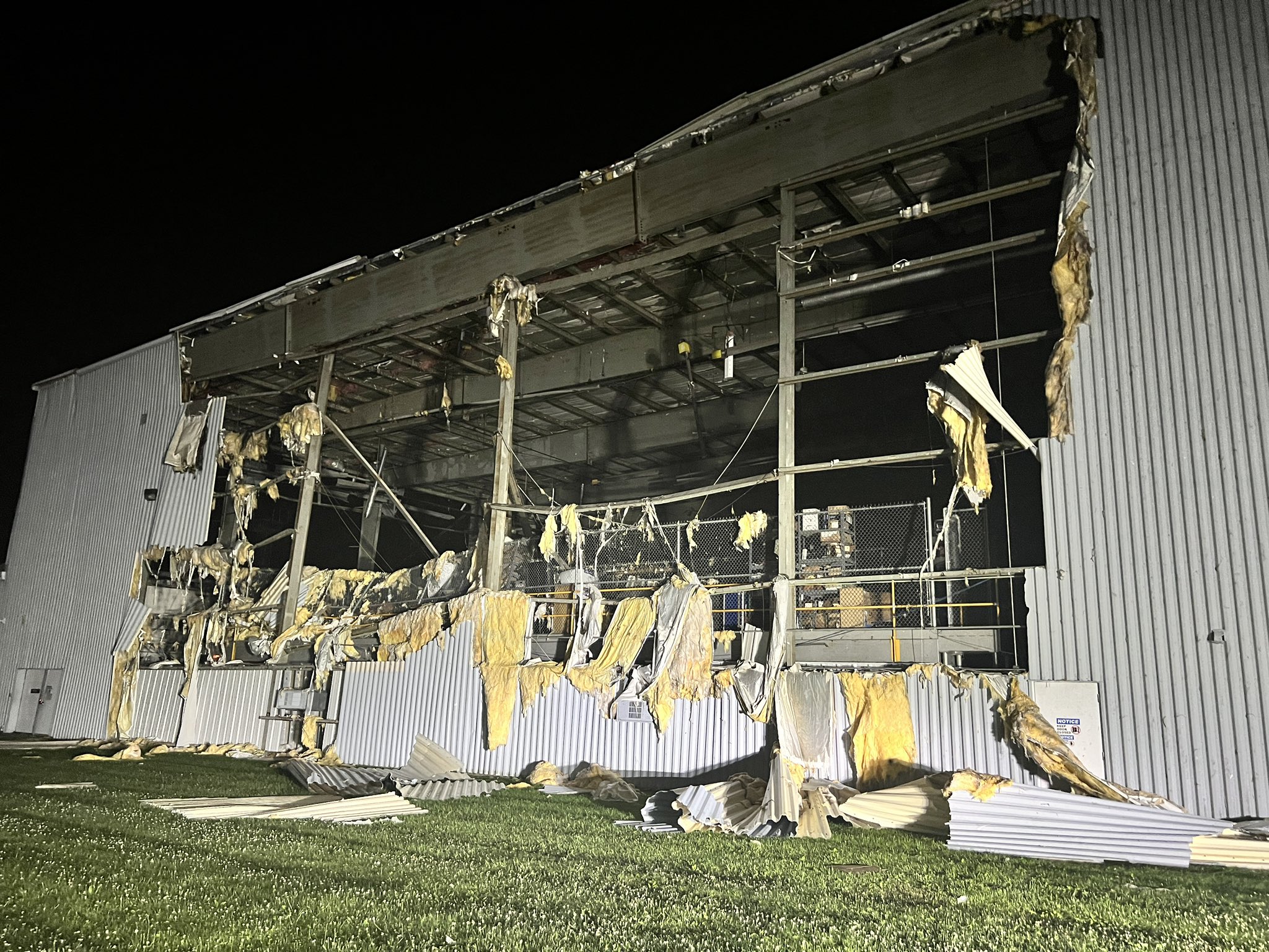
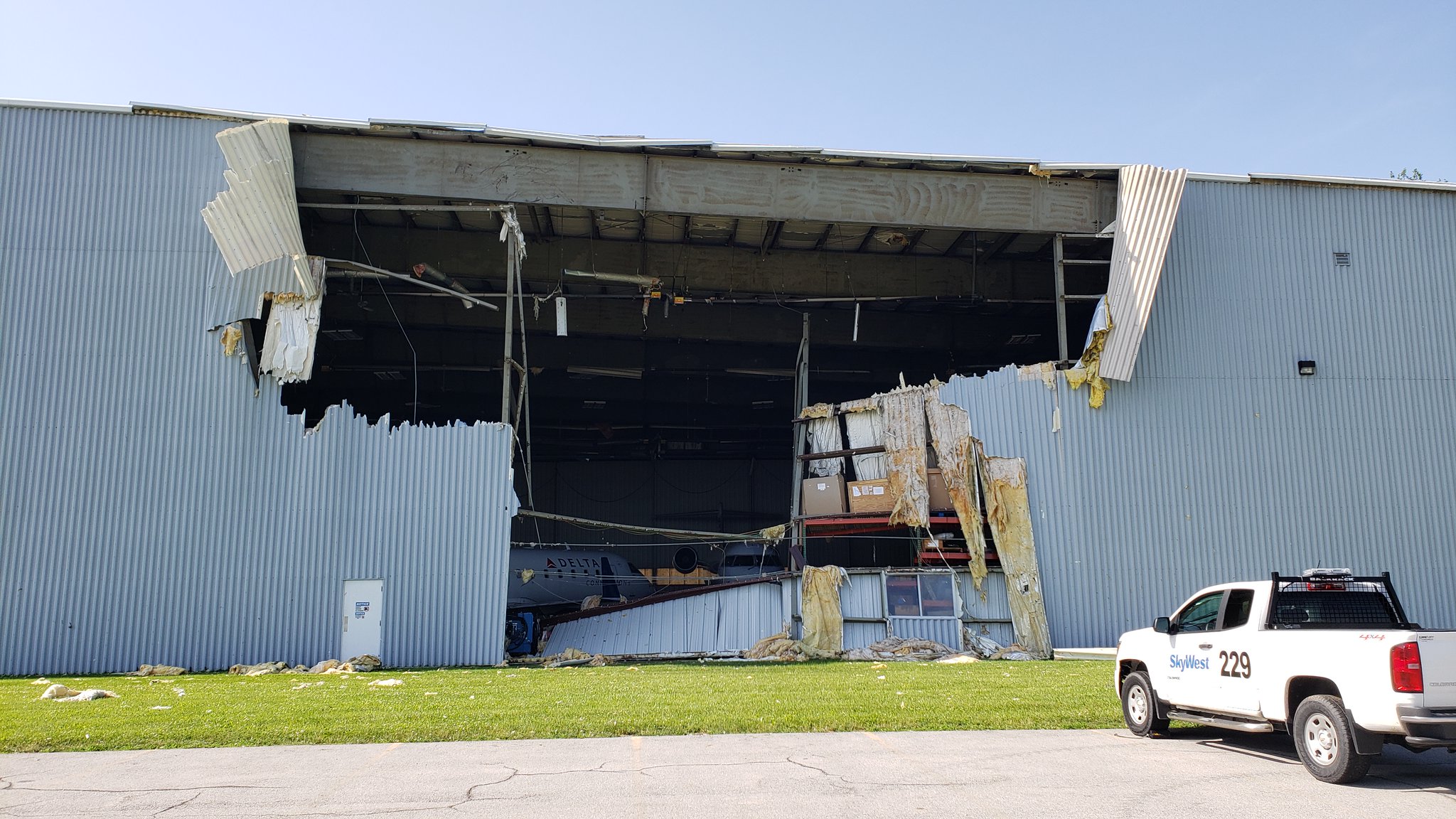
| Damage at the KFWA SkyWest Terminal (Charles Peek - Weather Channel) |
Damage at the KFWA SkyWest Terminal (Emily Dwire - WANE 15) |
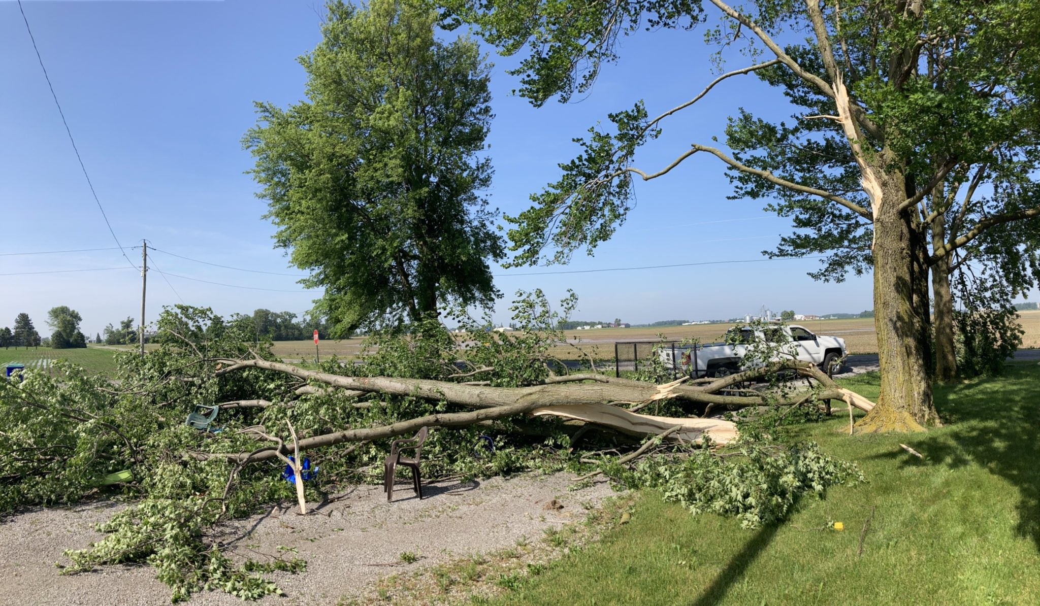
Large tree limbs snapped in Ossian, IN (Lance Huffman @Lance6613) |
Shelf Cloud in St. Joseph County, IN (@Byron20160) |
 |
 |
 |
 |
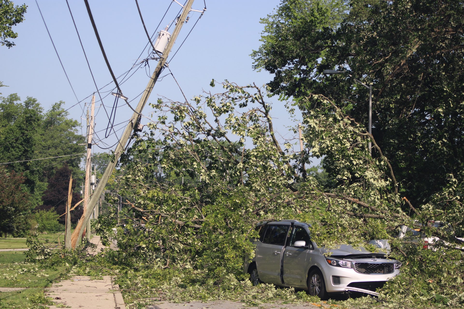
| Trees and powerlines down on a car in Waynedale, IN (Ashleigh Lindsey - @ashleighsmoot) |
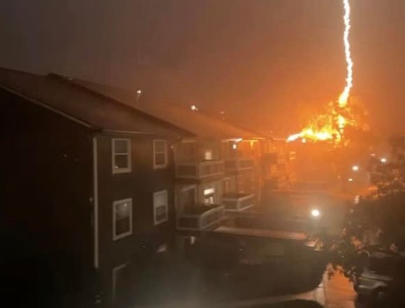
A fire broke out at Canterbury Green Apartments in Fort Wayne, IN due to a lightning strike (Austin Michael Fancher) |
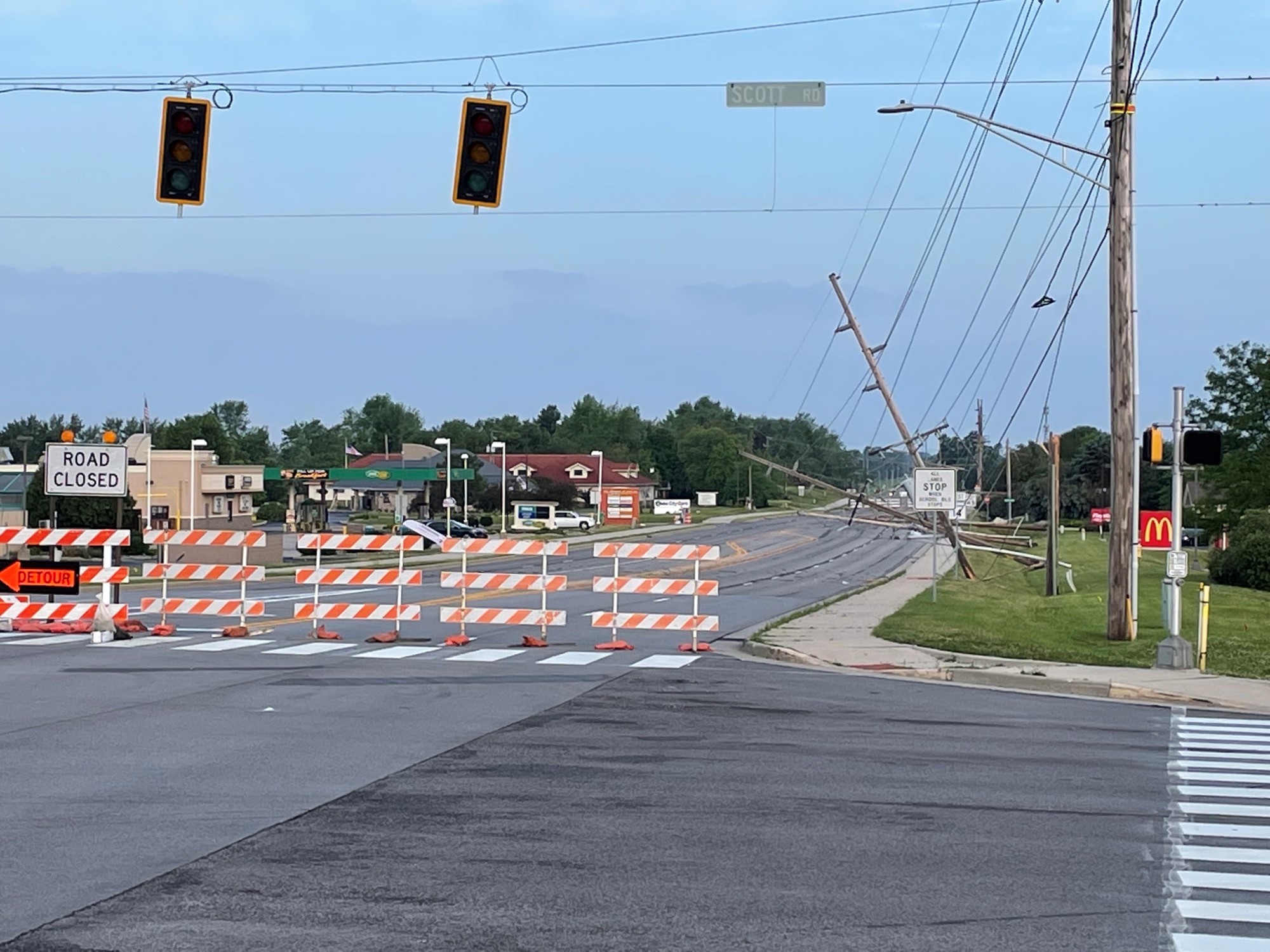
Powerlines down on Illinois Road in Fort Wayne, IN (Emily Dwire - WANE 15) |
Straightline wind damage on Redspire Blvd in Goshen, IN (GHS Weather) |
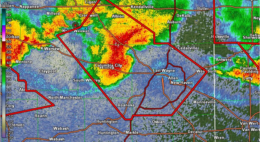
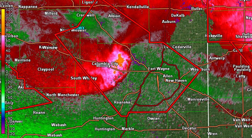
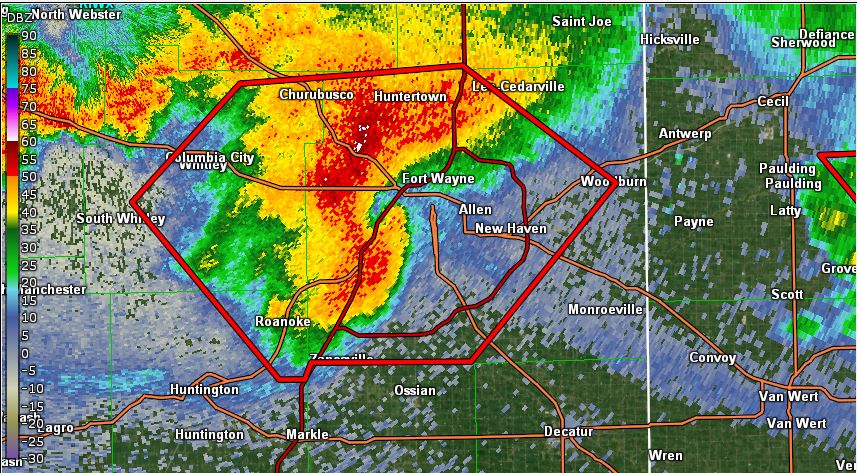
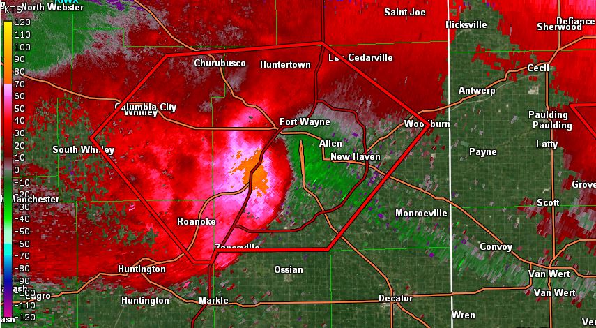
Radar
These images show the stronger portion of the line of storms that blasted through Fort Wayne, IN causing the 98 mph wind gust at the Fort Wayne International Airport around 10-11 pm EDT.
 |
 |
 |
 |
| 10:10 pm EDT 6/13/22 KIWX Reflectivity (GR2 Analyst) | 10:10 pm EDT 6/13/22 KIWX Base Velocity (GR2 Analyst) | 10:35 pm EDT 6/13/22 KIWX Reflectivity (GR2 Analyst) | 10:35 pm EDT 6/13/22 KIWX Base Velocity (GR2 Analyst) |
Storm Reports
PRELIMINARY LOCAL STORM REPORT...SUMMARY
NATIONAL WEATHER SERVICE NORTHERN INDIANA
105 PM EDT TUE JUN 14 2022
..TIME... ...EVENT... ...CITY LOCATION... ...LAT.LON...
..DATE... ....MAG.... ..COUNTY LOCATION..ST.. ...SOURCE....
..REMARKS..
1101 PM FLASH FLOOD POE 40.94N 85.09W
06/13/2022 ALLEN IN AMATEUR RADIO
6 INCHES OF WATER OVER ROAD ACROSS
WINCHESTER ROAD IN 15000 BLOCK. ALSO SEVERAL
TREES DOWN UP TO 1 FOOT IN DIAMETER.
0943 PM FLASH FLOOD 2 NNE GOSHEN 41.60N 85.82W
06/13/2022 ELKHART IN PUBLIC
REPORT FROM MPING: STREET/ROAD FLOODING;
STREET/ROAD CLOSED; VEHICLES STRANDED.
0924 PM FLASH FLOOD ANGOLA 41.64N 84.99W
06/13/2022 STEUBEN IN PUBLIC
REPORT FROM MPING: STREET/ROAD FLOODING;
STREET/ROAD CLOSED; VEHICLES STRANDED.
0827 PM FLOOD 2 SW THREE RIVERS 41.93N 85.65W
06/13/2022 ST. JOSEPH MI PUBLIC
REPORT FROM MPING: RIVER/CREEK OVERFLOWING;
CROPLAND/YARD/BASEMENT FLOODING.
0936 PM FLOOD 1 NW MONTPELIER 41.59N 84.61W
06/13/2022 WILLIAMS OH PUBLIC
REPORT FROM MPING: RIVER/CREEK OVERFLOWING;
CROPLAND/YARD/BASEMENT FLOODING.
0509 PM HAIL 3 S FORT WAYNE 41.04N 85.14W
06/13/2022 M0.88 INCH ALLEN IN PUBLIC
TIME ESTIMATED FROM RADAR.
1026 PM HAIL 1 SW HUNTERTOWN 41.22N 85.18W
06/13/2022 E1.75 INCH ALLEN IN NWS EMPLOYEE
1048 PM HAIL 2 NE HESSEN CASSEL 40.99N 85.06W
06/13/2022 U1.00 INCH ALLEN IN PUBLIC
REPORT FROM MPING: QUARTER (1.00 IN.).
0905 PM HAIL 2 ESE ELKHART 41.68N 85.94W
06/13/2022 E1.00 INCH ELKHART IN PUBLIC
SOCIAL MEDIA REPORT OF QUARTER SIZED HAIL
(ABOUT 1 INCH) IN ELKHART IN ELKHART COUNTY
INDIANA.
0915 PM HAIL 1 NW JIMTOWN 41.65N 86.03W
06/13/2022 U1.00 INCH ELKHART IN PUBLIC
REPORT FROM MPING: QUARTER (1.00 IN.).
0926 PM HAIL 2 SSW DUNLAP 41.61N 85.94W
06/13/2022 U0.75 INCH ELKHART IN PUBLIC
REPORT FROM MPING.
0930 PM HAIL 3 NW GOSHEN 41.60N 85.88W
06/13/2022 U0.75 INCH ELKHART IN PUBLIC
REPORT FROM MPING.
0910 PM HAIL 2 E GRANGER 41.74N 86.10W
06/13/2022 M0.88 INCH ST. JOSEPH IN PUBLIC
0736 PM HAIL 3 ENE PAW PAW LAKE 42.23N 86.23W
06/13/2022 U0.75 INCH BERRIEN MI PUBLIC
REPORT FROM MPING: DIME (0.75 IN.).
0836 PM HAIL 2 E STEVENSVILLE 42.02N 86.49W
06/13/2022 U0.75 INCH BERRIEN MI PUBLIC
REPORT FROM MPING: DIME (0.75 IN.).
1018 PM LIGHTNING 4 ESE WALLEN 41.14N 85.09W
06/13/2022 ALLEN IN BROADCAST MEDIA
LIGHTNING STRIKE AT CANTERBURY GREEN
APARTMENTS STARTED A FIRE. TIME ESTIMATED
FROM RADAR.
1026 PM LIGHTNING 4 NE WALLEN 41.20N 85.12W
06/13/2022 ALLEN IN PUBLIC
LIGHTNING STRIKE CAUSED DAMAGE TO THE ATTIC
OF A HOME ON THE 12000 BLOCK OF HARVEST BAY
DRIVE. NO INJURIES WERE REPORTED. TIME
ESTIMATED FROM RADAR.
1032 PM LIGHTNING 1 E WALLEN 41.16N 85.15W
06/13/2022 ALLEN IN PUBLIC
LIGHTNING STRUCK A HOUSE ON WALLEN ROAD,
BETWEEN COLDWATER ROAD AND LIMA ROAD. MINOR
DAMAGE TO SIDING AND ROOF OF THE HOUSE, AS
WELL AS TO A ROUTER. NO INJURIES WERE
REPORTED.
1038 PM NON-TSTM WND GST 4 SSW HUNTINGTON 40.83N 85.53W
06/13/2022 M43 MPH HUNTINGTON IN MESONET
MESONET STATION CW9663 HUNTINGTON.
0936 PM NON-TSTM WND GST 2 S HALLOCK 41.50N 84.56W
06/13/2022 M40 MPH WILLIAMS OH MESONET
MESONET STATION DVI01255 BRYAN.
1045 PM TSTM WND DMG DECATUR 40.84N 84.93W
06/13/2022 ADAMS IN PUBLIC
LARGE LIMBS DOWN, TREE SPLIT.
1051 PM TSTM WND DMG 1 WNW DECATUR 40.83N 84.94W
06/13/2022 ADAMS IN AMATEUR RADIO
MULTIPLE TREES DOWN. ALSO ELECTRICAL FIRE
FROM POWER POLE.
0957 PM TSTM WND DMG 3 NNW NEW HAVEN 41.11N 85.05W
06/13/2022 ALLEN IN PUBLIC
REPORT FROM MPING: TREES UPROOTED OR
SNAPPED; ROOF BLOWN OFF.
1012 PM TSTM WND DMG 2 SSW LAKE EVERETT 41.13N 85.33W
06/13/2022 ALLEN IN PUBLIC
TREE THROUGH HOUSE, BETWEEN US 30 AND
WASHINGTON CENTER, NEAR THE ALLEN/ WHITLEY
COUNTY LINE.
1015 PM TSTM WND DMG 2 SW LAKE EVERETT 41.13N 85.34W
06/13/2022 ALLEN IN PUBLIC
MULTIPLE TREES UPROOTED.
1015 PM TSTM WND DMG 1 NE ROLLING HILLS 41.03N 85.26W
06/13/2022 ALLEN IN PUBLIC
SOCIAL MEDIA REPORT OF LARGE ESTIMATED 24
INCH DIAMETER TREE LIMB SNAPPED OFF NEAR
ROLLING HILLS IN ALLEN COUNTY INDIANA.
1018 PM TSTM WND DMG 3 ESE ARCOLA 41.09N 85.24W
06/13/2022 ALLEN IN NWS EMPLOYEE
TRAIN BLOWN OFF THE TRACKS NEAR BASS ROAD.
TIME ESTIMATED FROM RADAR.
1020 PM TSTM WND DMG 2 SSE ARI 41.23N 85.24W
06/13/2022 ALLEN IN PUBLIC
MULTIPLE TREES SNAPPED. TIME ESTIMATED FROM
RADAR.
1020 PM TSTM WND DMG 2 SSE ARCOLA 41.08N 85.28W
06/13/2022 ALLEN IN BROADCAST MEDIA
POWER LINES KNOCKED DOWN ALONG WESTBOUND
ILLINOIS ROAD, NEAR THE INTERSECTION WITH
SCOTT ROAD. TIME ESTIMATED FROM RADAR.
1023 PM TSTM WND DMG 2 SSE CHURUBUSCO 41.21N 85.31W
06/13/2022 ALLEN IN AMATEUR RADIO
MULTIPLE TREES DOWN.
1025 PM TSTM WND DMG 3 SSW FORT WAYNE 41.03N 85.17W
06/13/2022 ALLEN IN AMATEUR RADIO
2 FOOT TREE ONTO HOUSE. PERSON TRAPPED IN
THE BELLA VISTA NEIGHBORHOOD.
1028 PM TSTM WND DMG 1 NW ROLLING HILLS 41.04N 85.28W
06/13/2022 ALLEN IN AMATEUR RADIO
MULTIPLE POWER POLES DOWN IN ROAD. ABOITE
CENTER RD NEAR HOMESTEAD HS.
1029 PM TSTM WND DMG 2 NE WALLEN 41.18N 85.13W
06/13/2022 ALLEN IN PUBLIC
MULTIPLE TREES DOWN. DUPONT AND COLDWATER.
1030 PM TSTM WND DMG ARCOLA 41.10N 85.29W
06/13/2022 ALLEN IN PUBLIC
PUBLIC REPORTED THAT THE LOCAL FIRE
DEPARTMENT HAD EVACUATED 10 STRUCTURES
(HOMES) DUE TO WIND DAMAGE IN ARCOLA IN
ALLEN COUNTY INDIANA.
1030 PM TSTM WND DMG ARCOLA 41.11N 85.29W
06/13/2022 ALLEN IN EMERGENCY MNGR
EMA REPORTS WIDESPREAD DAMAGE THROUGHOUT
ALLEN CO, BUT ESPECIALLY IN ARCOLA. MULTIPLE
HOMES DAMAGED AND DESTROYED. MOST ROADS IN
THE AREA ARE IMPASSABLE DUE TO DOWNED WIRES
AND TREES. DOZENS OF TREES ON HOMES.
SIGNIFICANT DAMAGE TO HOMES AND BUSINESSES.
1035 PM TSTM WND DMG 2 NNE FORT WAYNE 41.10N 85.13W
06/13/2022 ALLEN IN PUBLIC
MULTIPLE TREES SNAPPED AND DOWN AT THE PARK
CENTER STATE STREET CAMPUS IN FORT WAYNE.
ESTIMATED TO BE AROUND 6-12 INCHES IN
DIAMETER. TIME ESTIMATED FROM RADAR.
1035 PM TSTM WND DMG 2 SW FORT WAYNE 41.05N 85.16W
06/13/2022 ALLEN IN TRAINED SPOTTER
TRAINED SPOTTER REPORTED ESTIMATED WIND
GUSTS AROUND 80 MPH AND LARGE TREES BROKEN
IN SOUTHWEST FORT WAYNE IN ALLEN COUNTY
INDIANA. POWER WAS ALSO LOST AT THE
LOCATION.
1035 PM TSTM WND DMG 1 N FORT WAYNE 41.08N 85.14W
06/13/2022 ALLEN IN BROADCAST MEDIA
NUMEROUS TREES DOWN OR UPROOTED, POWERLINES
DOWN, AND ROOF DAMAGE TO THE WILLOWS OF
COVENTRY APARTMENTS COMPLEX. TIME ESTIMATED
FROM RADAR.
1039 PM TSTM WND DMG 2 E NINE MILE 40.97N 85.19W
06/13/2022 ALLEN IN BROADCAST MEDIA
SIGNIFICANT STRUCTURAL DAMAGE TO THE SKYWEST
AIRLINES BUILDING AT FORT WAYNE INT. AP. 98
MPH WIND GUST REPORTED AT THE AIRPORT.
1039 PM TSTM WND DMG 1 N ROLLING HILLS 41.04N 85.27W
06/13/2022 ALLEN IN BROADCAST MEDIA
2 FT DIAMETER TREE SNAPPED IN HALF. HEALTHY
TREE.
1039 PM TSTM WND DMG 4 SSW FORT WAYNE 41.03N 85.17W
06/13/2022 ALLEN IN AMATEUR RADIO
MULTIPLE TREES DOWN ON MULTIPLE HOUSES, 2700
BLOCK OF FAIRBROOK COURT.
1040 PM TSTM WND DMG 3 NNE YODER 40.97N 85.16W
06/13/2022 ALLEN IN PUBLIC
HEALTHY 2 FOOT DIAMETER OAK TREE SNAPPED OFF
ABOUT 20 FEET ABOVE THE GROUND.
1045 PM TSTM WND DMG 1 SSE YODER 40.92N 85.17W
06/13/2022 ALLEN IN PUBLIC
TREE DOWN AND BLOCKING THE ROAD ALONG THE
WELLS/ALLEN COUNTY LINE ALONG 1200 N AND
HIGHWAY 1. TIME ESTIMATED BY RADAR.
0919 PM TSTM WND DMG 3 SW DUNLAP 41.61N 85.97W
06/13/2022 ELKHART IN TRAINED SPOTTER
MULTIPLE TREES DOWNED ALONG CR-28. TIME
ESTIMATED BY RADAR.
0925 PM TSTM WND DMG 2 WNW GOSHEN 41.59N 85.88W
06/13/2022 ELKHART IN PUBLIC
MULTIPLE TREES SNAPPED ALONG REDSPIRE BLVD.
ESTIMATED TO BE AROUND 6-12 INCHES IN
DIAMETER. TIME ESTIMATED FROM RADAR.
0930 PM TSTM WND DMG 1 SE GOSHEN 41.57N 85.82W
06/13/2022 ELKHART IN NWS EMPLOYEE
NWS EMPLOYEE REPORTED A LARGE TREE SNAPPED
20 FEET UP AND FELL ONTO A HOUSE WITH
POSSIBLE DAMAGE TO A VEHICLE IN GOSHEN IN
ELKHART COUNTY INDIANA . NO INJURIES. PEA
SIZED HAIL ALSO AT THE TIME.
0946 PM TSTM WND DMG GOSHEN 41.58N 85.84W
06/13/2022 ELKHART IN PUBLIC
CORRECTS PREVIOUS TSTM WND DMG REPORT FROM
GOSHEN. REPORT FROM MPING: 3-INCH TREE LIMBS
BROKEN; POWER POLES BROKEN.
0448 PM TSTM WND DMG ROANOKE 40.97N 85.38W
06/13/2022 HUNTINGTON IN LAW ENFORCEMENT
TREE DOWN ACROSS THE ROADWAY AT 2592 E 1100
N IN ROANOKE. TIME ESTIMATED FROM RADAR.
0945 PM TSTM WND DMG 1 NE HUNTINGTON 40.89N 85.49W
06/13/2022 HUNTINGTON IN PUBLIC
SHED DESTROYED.
1020 PM TSTM WND DMG ROANOKE 40.97N 85.37W
06/13/2022 HUNTINGTON IN PUBLIC
2 LARGE TREES DOWN IN ROANOKE. ALSO SEVERAL
SMALLER TREE LIMBS DOWN, INCLUDING ONE ONTO
SHERIFF DEPUTY VEHICLE WITH MINOR DAMAGE.
0930 PM TSTM WND DMG NORTH WEBSTER 41.33N 85.70W
06/13/2022 KOSCIUSKO IN PUBLIC
NUMEROUS TREES DOWN, SOME OVER ROADS.
0938 PM TSTM WND DMG 2 ESE LAKE WAWASEE 41.39N 85.67W
06/13/2022 KOSCIUSKO IN PUBLIC
TREES REPORTED DOWN ON MORRISON ISLAND ON
EAST SIDE OF LAKE WAWASEE.
0940 PM TSTM WND DMG 1 SW MONOQUET 41.28N 85.87W
06/13/2022 KOSCIUSKO IN PUBLIC
TREE DOWN OVER ROAD NEAR MADISON ELEMENTARY.
0940 PM TSTM WND DMG 1 NW TIPPECANOE LAKE 41.34N 85.78W
06/13/2022 KOSCIUSKO IN NWS EMPLOYEE
LARGE TREE DOWN ACROSS T34C LANE. POWER
LINES DOWN.
0940 PM TSTM WND DMG 1 NNW TIPPECANOE LAKE 41.34N 85.77W
06/13/2022 KOSCIUSKO IN NWS EMPLOYEE
6 TO 8 INCH TREE LIMB DOWN.
0940 PM TSTM WND DMG 2 SSE LAKE WAWASEE 41.37N 85.68W
06/13/2022 KOSCIUSKO IN NWS EMPLOYEE
LARGE TREE SNAPPED AND BLOCKING THE ROADWAY
ALONG N 850 E. MULTIPLE POWERLINES DOWN TOO.
TIME ESTIMATED FROM RADAR.
0940 PM TSTM WND DMG 2 SSE LAKE WAWASEE 41.38N 85.68W
06/13/2022 KOSCIUSKO IN PUBLIC
PICTURE OF LARGE TREE DOWN ON HATCHERY ROAD
ON SOUTH SIDE OF LAKE WAWASEE.
0945 PM TSTM WND DMG NORTH WEBSTER 41.33N 85.70W
06/13/2022 KOSCIUSKO IN NWS EMPLOYEE
NUMEROUS TREE LIMBS DOWN ALONG SR 13 IN AND
SOUTH OF N WEBSTER.
0950 PM TSTM WND DMG 1 NNE SECHRIST LAKE 41.31N 85.71W
06/13/2022 KOSCIUSKO IN NWS EMPLOYEE
CORRECTS PREVIOUS TSTM WND DMG REPORT FROM 1
NNE SECHRIST LAKE. LARGE TREE UPROOTED AND
FELL INTO A HOUSE NEAR 500 N AND 700 E.
0950 PM TSTM WND DMG 1 SE NORTH WEBSTER 41.32N 85.69W
06/13/2022 KOSCIUSKO IN PUBLIC
PUBLIC REPORT OF THUNDERSTORM WIND DAMAGE OF
2 LARGE (80 TO 85 FOOT) TREES DOWNED NEAR
NORTH WEBSTER IN KOSCIUSKO COUNTY IN
INDIANA. ONE TREE WAS COMPLETELY ACROSS EAST
BACKWATER RD. NO INJURIES REPORTED.
0955 PM TSTM WND DMG 2 W CROMWELL 41.41N 85.66W
06/13/2022 KOSCIUSKO IN PUBLIC
ENCHANTED HILLS SUBDIVISION BETWEEN SYRACUSE
AND CROMWELL, IN. 18 INCH DIAMETER TREE
BRANCH DOWN ACROSS AND INTO A MOBILE HOME.
NEXT HOUSE TO THE EAST HAS A 12 INCH
DIAMETER BRANCH ACROSS THE ROOF NO
PENETRATION INTO THE LIVING AREA.
0925 PM TSTM WND DMG WANATAH 41.43N 86.89W
06/13/2022 LA PORTE IN PUBLIC
CORRECTS PREVIOUS TSTM WND DMG REPORT FROM
WANATAH. LARGE TREE DOWNED ACROSS THE ROAD
NEAR THE CENTER OF TOWN.
0946 PM TSTM WND DMG LIGONIER 41.46N 85.59W
06/13/2022 NOBLE IN PUBLIC
1 FT DIAMETER HEALTHY LIMB DOWN AT THE
LIGONIER PUBLIC LIBRARY.
0950 PM TSTM WND DMG 2 SSW CROMWELL 41.38N 85.63W
06/13/2022 NOBLE IN NWS EMPLOYEE
MULTIPLE TREES DOWN ALONG W COUNTY ROAD 200
N NEAR THE INTERSECTION WITH US-5. TIME
ESTIMATED FROM RADAR.
0950 PM TSTM WND DMG ALBION 41.40N 85.42W
06/13/2022 NOBLE IN EMERGENCY MNGR
EMA REPORTS WIDESPREAD DAMAGE IN SW NOBLE
COUNTY. MULTIPLE TREES DOWN ACROSS ROADS,
TREES ON VEHICLES, TREES ON SEVERAL HOUSES,
TREES IN POWER LINES, SMALL BARN DESTROYED.
0855 PM TSTM WND DMG LAKE GAUGE 41.70N 85.11W
06/13/2022 STEUBEN IN EMERGENCY MNGR
REPORTS OF ROOF COLLAPSE AND PARTIAL
REMOVAL.
0910 PM TSTM WND DMG 1 ESE STROH 41.58N 85.19W
06/13/2022 STEUBEN IN TRAINED SPOTTER
TWO 30 INCH DIAMETER TREES BROKEN AT BASE OF
TRUNK.
0916 PM TSTM WND DMG 1 SSE ANGOLA 41.63N 85.00W
06/13/2022 STEUBEN IN PUBLIC
REPORT FROM MPING: 3-INCH TREE LIMBS BROKEN;
POWER POLES BROKEN.
0920 PM TSTM WND DMG 1 S ANGOLA 41.63N 85.00W
06/13/2022 STEUBEN IN PUBLIC
REPORT FROM MPING: 3-INCH TREE LIMBS BROKEN;
POWER POLES BROKEN.
0930 PM TSTM WND DMG 4 NE LAKE JAMES 41.75N 85.01W
06/13/2022 STEUBEN IN PUBLIC
MULTIPLE TREES DOWN NEAR LAKE GEORGE.
1045 PM TSTM WND DMG 3 SW POE 40.91N 85.13W
06/13/2022 WELLS IN PUBLIC
SEVERAL TREE LIMBS ESTIMATED TO BE 6-12
INCHES IN DIAMETER SNAPPED OFF TREE AND FELL
INTO THE INTERSECTION OF 500 E AND 1150 N.
TIME ESTIMATED FROM RADAR.
1000 PM TSTM WND DMG 2 SW TRI-LAKES 41.22N 85.46W
06/13/2022 WHITLEY IN EMERGENCY MNGR
TREE ONTO CAR. PERSON TRAPPED IN CAR. LINES
ALSO DOWN. SR 109 AND CR 400 N.
1000 PM TSTM WND DMG 3 SSW MERRIAM 41.25N 85.46W
06/13/2022 WHITLEY IN EMERGENCY MNGR
TREE DOWN INTO HOUSE. PERSON TRAPPED IN
HOUSE.
1000 PM TSTM WND DMG 1 N BLUE LAKE 41.26N 85.36W
06/13/2022 WHITLEY IN NWS EMPLOYEE
TWO TREES SNAPPED OUTSIDE OF BLUE RIDGE
ESTATES AND IN THE ROADWAY (NORTHBOUND
US-33). TIME ESTIMATED FROM RADAR.
1000 PM TSTM WND DMG COLUMBIA CITY 41.16N 85.49W
06/13/2022 WHITLEY IN PUBLIC
MULTIPLE TREES DOWN, SOME ON POWER LINES.
1005 PM TSTM WND DMG 2 WNW COESSE 41.14N 85.43W
06/13/2022 WHITLEY IN NWS EMPLOYEE
OFF DUTY NWS EMPLOYEE REPORTED SIDING IN HIS
YARD.
1025 PM TSTM WND DMG 2 S DUNFEE 41.06N 85.34W
06/13/2022 WHITLEY IN AMATEUR RADIO
MULTIPLE TREES DOWN AT COVINGTON AND COUNTY
LINE ROAD.
1028 PM TSTM WND DMG 1 SW ETNA 41.27N 85.59W
06/13/2022 WHITLEY IN EMERGENCY MNGR
UNKNOWN SPECIFIC LOCATION OF 2 TREES ONTO
CARS ON 700 N FROM EMA.
1028 PM TSTM WND DMG 1 N TRI-LAKES 41.24N 85.48W
06/13/2022 WHITLEY IN PUBLIC
AMY BIGGS SAID MARK AS DAMAGE POINT, WAITING
ON DETAILS.
1033 PM TSTM WND DMG 2 SSW MERRIAM 41.26N 85.46W
06/13/2022 WHITLEY IN PUBLIC
UPROOTED 36 INCH DIAMETER MATURE OAK TREE
INTO SHED.
0720 PM TSTM WND DMG 1 NE LAKE MICHIGAN BEAC 42.22N 86.37W
06/13/2022 BERRIEN MI EMERGENCY MNGR
VEHICLE ACCIDENT INTO POWER POLE (ACCIDENT
CAUSE ENHANCED BY STORM CONDITIONS).
0722 PM TSTM WND DMG 1 S BENTON HARBOR 42.10N 86.45W
06/13/2022 BERRIEN MI EMERGENCY MNGR
LARGE TREE DOWN ON POWER LINES.
0725 PM TSTM WND DMG SAINT JOSEPH 42.10N 86.49W
06/13/2022 BERRIEN MI EMERGENCY MNGR
LARGE TREE DOWN ON LINES.
0725 PM TSTM WND DMG SAINT JOSEPH 42.10N 86.49W
06/13/2022 BERRIEN MI EMERGENCY MNGR
LARGE TREE DOWN ON HOUSE.
0735 PM TSTM WND DMG 3 ENE PAW PAW LAKE 42.23N 86.23W
06/13/2022 BERRIEN MI PUBLIC
REPORT FROM MPING: TREES UPROOTED OR
SNAPPED.
0850 PM TSTM WND DMG COLDWATER 41.94N 85.00W
06/13/2022 BRANCH MI TRAINED SPOTTER
SPOTTER REPORT OF 5 LARGE TREES DOWN SOUTH
OF COLDWATER IN BRANCH COUNTY MICHIGAN.
0755 PM TSTM WND DMG 1 NNW MARCELLUS 42.04N 85.83W
06/13/2022 CASS MI TRAINED SPOTTER
SMALL TREE LIMB DAMAGE. REPORT OF A CAR ON
ITS SIDE. THROUGH SPOTTERNETWORK.ORG. TIME
ESTIMATED BY RADAR.
0830 PM TSTM WND DMG MARCELLUS 42.03N 85.81W
06/13/2022 CASS MI PUBLIC
SOCIAL MEDIA REPORT OF LARGE TREE DOWN
ACROSS ROAD SOUTH OF MARCELLUS IN CASS
COUNTY MICHIGAN.
0900 PM TSTM WND DMG HILLSDALE 41.92N 84.64W
06/13/2022 HILLSDALE MI PUBLIC
REPORT FROM MPING: 1-INCH TREE LIMBS BROKEN;
SHINGLES BLOWN OFF.
0810 PM TSTM WND DMG 2 S HOWARDSVILLE 42.00N 85.72W
06/13/2022 ST. JOSEPH MI TRAINED SPOTTER
LARGE TREE LIMB TO 5 FEET IN DIAMETER ON
BENT RD.
0830 PM TSTM WND DMG THREE RIVERS 41.94N 85.63W
06/13/2022 ST. JOSEPH MI PUBLIC
PUBLIC SPOTTER REPORT OF 2 SMALL TREES DOWN
AND PEA SIZED HAIL NEAR THREE RIVERS IN ST.
JOSEPH COUNTY MICHIGAN.
0832 PM TSTM WND DMG THREE RIVERS 41.94N 85.63W
06/13/2022 ST. JOSEPH MI PUBLIC
SOCIAL MEDIA REPORT OF LARGE TREE DOWN
ACROSS US 131 SOUTH OF THREE RIVERS IN ST.
JOSEPH COUNTY MICHIGAN.
1043 PM TSTM WND DMG 4 SE HARROD 40.65N 83.89W
06/13/2022 ALLEN OH PUBLIC
REPORT FROM MPING: SHINGLES BLOWN OFF ROOF,
SMALL BRANCHES DOWNED.
1125 PM TSTM WND DMG 1 ESE LIMA 40.74N 84.10W
06/13/2022 ALLEN OH EMERGENCY MNGR
NUMEROUS REPORTS OF TREES AND POWER LINES
DOWN ACROSS THE COUNTY.
1015 PM TSTM WND DMG 1 N DEFIANCE 41.30N 84.36W
06/13/2022 DEFIANCE OH AMATEUR RADIO
2 FOOT DIAMETER TREE DOWN ON CLINTON ST AT
DEFIANCE COLLEGE.
0205 AM TSTM WND DMG 1 NNE WAUSEON 41.57N 84.14W
06/14/2022 FULTON OH PUBLIC
REPORT FROM MPING: SMALL LIMBS DOWNED-NO
SIZE PROVIDED.
1004 PM TSTM WND DMG HOLGATE 41.25N 84.13W
06/13/2022 HENRY OH EMERGENCY MNGR
0957 AM TSTM WND DMG 1 NNW OTTAWA 41.04N 84.05W
06/14/2022 PUTNAM OH PUBLIC
SHINGLE DAMAGE AND FIVE BIG HEALTHY TREES
DOWN. REPORTER NOT SURE ON WHAT TIME IT
OCCURRED LAST NIGHT.
1100 PM TSTM WND DMG WREN 40.80N 84.77W
06/13/2022 VAN WERT OH EMERGENCY MNGR
MULTIPLE TREES DOWN IN WREN.
1100 PM TSTM WND DMG OHIO CITY 40.77N 84.62W
06/13/2022 VAN WERT OH TRAINED SPOTTER
TRAINED SPOTTER REPORTS SEVERAL LARGE TREES
DOWNED AROUND OHIO CITY IN VAN WERT COUNTY
OHIO. ONE TREE WAS UPROOTED.
1108 PM TSTM WND DMG 3 SE OHIO CITY 40.74N 84.58W
06/13/2022 VAN WERT OH PUBLIC
CORRECTS PREVIOUS TSTM WND DMG REPORT FROM 3
SE OHIO CITY. SEMI TIPPED OVER ON US 127 AND
SR 81. UPDATED INFORMATION SUGGESTS THE SEMI
WAS NOT BLOWN OVER, IT CRASHED WITH ANOTHER
VEHICLE. IT WAS STORM-RELATED POSSIBLY DUE
TO LOW VISIBILITY.
0930 PM TSTM WND DMG MONTPELIER 41.58N 84.60W
06/13/2022 WILLIAMS OH AMATEUR RADIO
WIRES REPORTED DOWN.
1039 PM TSTM WND GST 2 ENE NINE MILE 40.98N 85.18W
06/13/2022 M98 MPH ALLEN IN ASOS
CORRECTS TIME ON PREVIOUS TSTM WND GST
REPORT FROM 2 ENE NINE MILE. ASOS STATION
KFWA FORT WAYNE INTERNATIONAL AP.
1040 PM TSTM WND GST YODER 40.93N 85.18W
06/13/2022 M76 MPH ALLEN IN TRAINED SPOTTER
TRAINED SPOTTER REPORTS MEASURED 76 MPH
GUSTS NEAR YODER IN ALLEN COUNTY INDIANA.
0940 PM TSTM WND GST 2 N NORTH WEBSTER 41.36N 85.70W
06/13/2022 E60 MPH KOSCIUSKO IN OFFICIAL NWS OBS
WIND GUSTS ESTIMATED TO AT LEAST 60 MPH.
0205 PM TSTM WND GST 2 NW CROMWELL 41.42N 85.64W
06/13/2022 M56 MPH NOBLE IN MESONET
MESONET STATION DVI03119 CROMWELL.
0905 PM TSTM WND GST OSCEOLA 41.67N 86.08W
06/13/2022 E50 MPH ST. JOSEPH IN PUBLIC
1030 PM TSTM WND GST 2 S COESSE 41.11N 85.40W
06/13/2022 M59 MPH WHITLEY IN MESONET
MESONET STATION PDU05 NORTHEAST PURDUE
AGRICULTURAL CE.
0926 PM TSTM WND GST 5 SSW FRONTIER 41.71N 84.65W
06/13/2022 M55 MPH HILLSDALE MI MESONET
MESONET STATION FW8073 CAMDEN.
0811 PM TSTM WND GST WHITE PIGEON 41.80N 85.64W
06/13/2022 E75 MPH ST. JOSEPH MI PUBLIC
WIND GUST REPORT OF 70-75 MPH FROM SOCIAL
MEDIA NEAR WHITE PIGEON IN ST. JOSEPH COUNTY
MICHIGAN.
0813 PM TSTM WND GST 3 SE CLEAR LAKE 41.92N 85.69W
06/13/2022 M73 MPH ST. JOSEPH MI TRAINED SPOTTER
RELAYED THROUGH SPOTTERNETWORK.ORG.
0838 PM TSTM WND GST THREE RIVERS 41.94N 85.63W
06/13/2022 M66 MPH ST. JOSEPH MI ASOS
ASOS REPORTS 66 MPH GUST FROM ENE AT THREE
RIVERS IN ST. JOSEPH COUNTY MICHIGAN.
1024 PM TSTM WND GST 3 ENE ROCKPORT 40.88N 83.95W
06/13/2022 M62 MPH ALLEN OH MESONET
0958 PM TSTM WND GST 3 NW BRUNERSBURG 41.33N 84.43W
06/13/2022 M61 MPH DEFIANCE OH ASOS
ASOS STATION KDFI DEFIANCE.
0935 PM TSTM WND GST 1 N OTTOKEE 41.62N 84.13W
06/13/2022 M46 MPH FULTON OH AWOS
AWOS STATION KUSE WAUSEON.
1005 PM TSTM WND GST CONTINENTAL 41.10N 84.27W
06/13/2022 M55 MPH PUTNAM OH AMATEUR RADIO
HALF INCH HAIL AS WELL.
1010 PM TSTM WND GST OTTAWA 41.02N 84.04W
06/13/2022 E60 MPH PUTNAM OH TRAINED SPOTTER
TRAINED SPOTTER REPORTED ESTIMATED WIND
GUSTS OF 60 MPH IN OTTAWA IN PUTNAM COUNTY
OHIO. ALSO REPORTED THE TOWN WAS WITHOUT
POWER.
1014 PM TSTM WND GST BELMORE 41.15N 83.94W
06/13/2022 M75 MPH PUTNAM OH EMERGENCY MNGR
1106 PM TSTM WND GST 1 N WILLSHIRE 40.76N 84.79W
06/13/2022 E70 MPH VAN WERT OH TRAINED SPOTTER
ESTIMATED 60 TO 70 MPH WINDS JUST NORTH OF
WILLSHIRE.
&&
$$
Rain Reports
PUBLIC INFORMATION STATEMENT
NATIONAL WEATHER SERVICE NORTHERN INDIANA
1028 AM EDT TUE JUN 14 2022

...PRECIPITATION REPORTS...

LOCATION                     AMOUNT    TIME/DATE       LAT/LON

...INDIANA...

...ALLEN COUNTY...
FORT WAYNE INTERNATIONAL AP  2.03 IN   0754 AM 06/14   40.98N/85.18W
HOAGLAND 1.5 SSW             1.62 IN   0709 AM 06/14   40.93N/85.00W
FORT WAYNE 1.6 S             1.29 IN   0800 AM 06/14   41.05N/85.14W

...ELKHART COUNTY...
GOSHEN 1.2 SW                1.71 IN   0700 AM 06/14   41.57N/85.85W
SYRACUSE 4.4 NNW             1.44 IN   0700 AM 06/14   41.48N/85.77W
ELKHART 3.0 SSE              1.37 IN   0800 AM 06/14   41.65N/85.94W
LIGONIER 4.3 WNW             1.00 IN   0800 AM 06/14   41.48N/85.67W

...KOSCIUSKO COUNTY...
CROMWELL 2.9 W               1.06 IN   0700 AM 06/14   41.40N/85.67W

...NOBLE COUNTY...
ALBION 9.5 SSW               1.12 IN   0700 AM 06/14   41.28N/85.51W

...ST. JOSEPH COUNTY...
GRANGER 1.8 ENE              1.48 IN   0700 AM 06/14   41.75N/86.11W
MISHAWAKA 3.9 ENE            1.26 IN   0720 AM 06/14   41.68N/86.10W
OSCEOLA                      1.24 IN   0435 AM 06/14   41.71N/86.08W

...STEUBEN COUNTY...
ANGOLA 4.1 N                 2.04 IN   0545 AM 06/14   41.70N/84.99W

...WHITLEY COUNTY...
COLUMBIA CITY 1.5 NNW        1.22 IN   0500 AM 06/14   41.18N/85.49W

...MICHIGAN...

...BERRIEN COUNTY...
1 NNE SAINT JOSEPH           1.60 IN   1114 PM 06/13   42.11N/86.48W
NILES                        1.26 IN   0435 AM 06/14   41.83N/86.27W

...HILLSDALE COUNTY...
MOSCOW 1.0 NE                2.71 IN   0700 AM 06/14   42.06N/84.50W
OSSEO 2.7 NE                 2.50 IN   0830 AM 06/14   41.90N/84.49W
JONESVILLE 0.2 WSW           2.39 IN   0707 AM 06/14   41.98N/84.67W
HILLSDALE                    2.30 IN   0815 AM 06/14   41.92N/84.58W
JEROME                       1.62 IN   0438 AM 06/14   42.02N/84.46W

...ST. JOSEPH COUNTY...
STURGIS KIRSCH               1.65 IN   0815 AM 06/14   41.80N/85.43W
2 SW WASEPI                  1.27 IN   0852 PM 06/13   41.92N/85.49W

...OHIO...

...DEFIANCE COUNTY...
DEFIANCE                     1.18 IN   0353 AM 06/14   41.33N/84.43W

...FULTON COUNTY...
WAUSEON 2.4 SW               1.51 IN   0700 AM 06/14   41.53N/84.17W
ARCHBOLD 4.7 NW              1.46 IN   0530 AM 06/14   41.57N/84.36W

...HENRY COUNTY...
NAPOLEON 1 SW                1.49 IN   0700 AM 06/14   41.38N/84.15W
MCCLURE 3.4 SSE              1.27 IN   0700 AM 06/14   41.33N/83.91W

...WILLIAMS COUNTY...
1.2 E BRYAN                  1.52 IN   0800 AM 06/14   41.46N/84.53W
PIONEER 2.3 S                1.42 IN   0700 AM 06/14   41.65N/84.55W
&&
Environment
 |
 |
 |
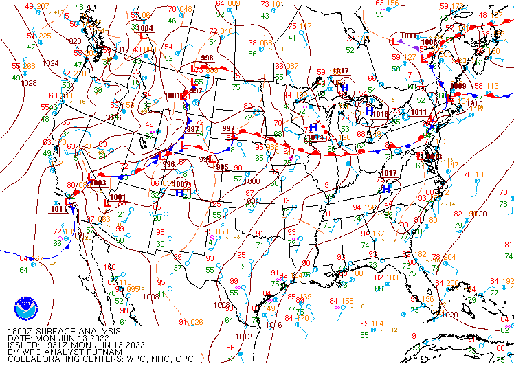
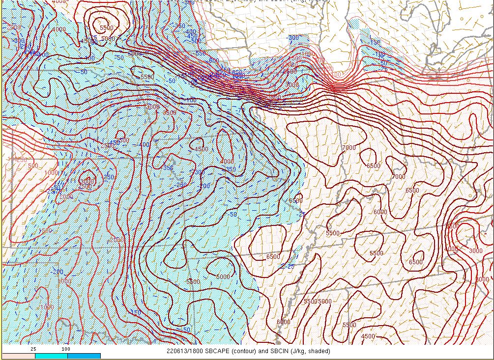
| Figure 1: 2PM EDT Surface Analysis shows a warm front draped across our area. This front became stationary and remained over our area through the late evening. | Figure 2: Very warm and humid conditions led to extreme instability (fuel for storms) along and south of the warm front. | Figure 3: Significant moisture pooling along the front also support strong storms and heavy rain. |
 |
 |
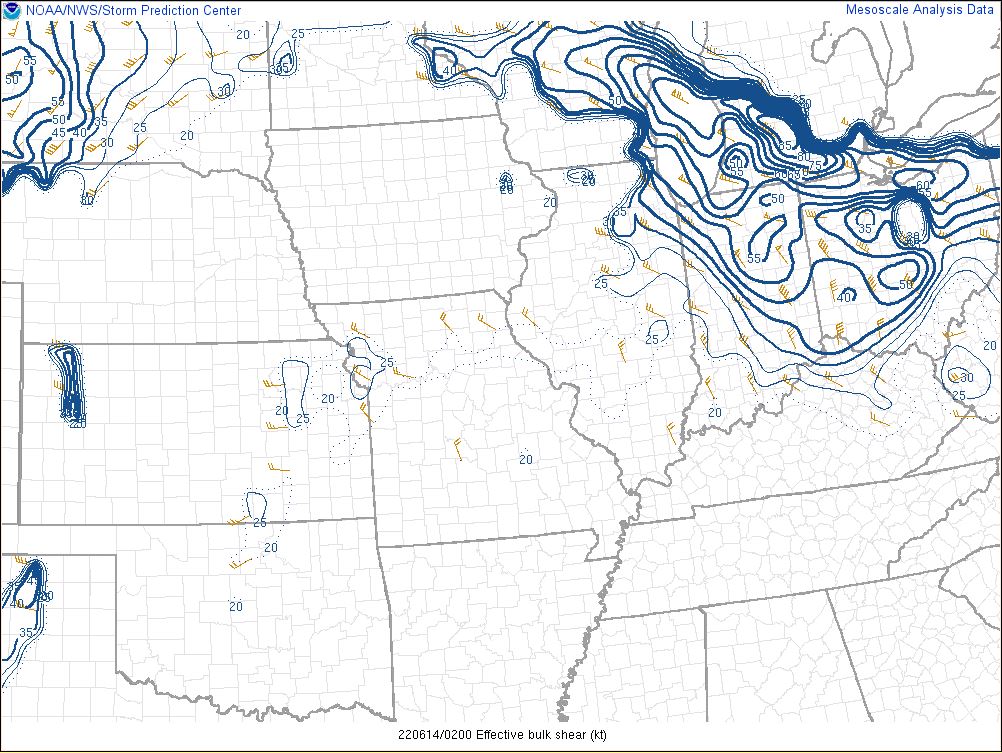 |
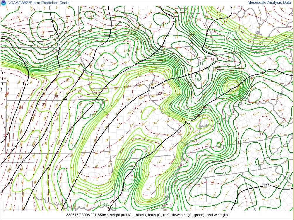
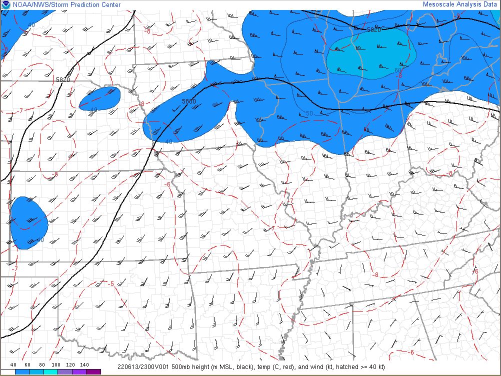
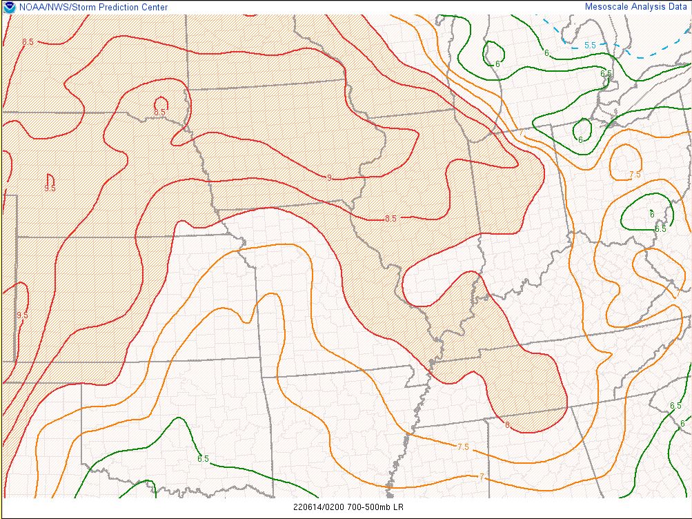
| Figure 4: An upper level disturbance provided additional forcing to support the generation of severe storms. | Figure 5: Lower levels were very warm (and moist) while upper levels were relatively cold. This is indicated by the high lapse rates which provide additional fuel for storms, particularly at night after the loss of daytime heating. | Figure 6: Significant wind shear (change in wind speed or direction with height) supported the organization of storms into a damaging multicell line. |
 |
Media use of NWS Web News Stories is encouraged! Please acknowledge the NWS as the source of any news information accessed from this site. |
|

