
Scattered strong to severe storms capable of sporadic large hail and severe winds are expected this afternoon and evening across portions of western Texas. Widespread showers and thunderstorms may produce isolated flash flooding across the Ozarks today and the Southeast into next week. Read More >
Overview
A strong storm system combined with weak instability to produce scattered severe weather across the area. Most of the severe weather in the form of large hail and isolated damaging wind gusts occurred across far northern Indiana, southern Lower Michigan, and extreme northwest Ohio. In addition to the severe weather, strong non-thunderstorm winds gusted to around 45 mph for many locations during the afternoon and early evening.
Wind & Hail:
Below is a map of the storm reports received during the event. This includes reports or large hail, damaging winds due to thunderstorms, and damage from non-thunderstorm winds.
.png)
Photos & Video
 |
 |
 |
 |
| Accumulating dime sized hail in La Porte county. Photo courtesy of WSBT |
Golf ball sized hail near Wanatah, IN. Photo courtesy of Isaac Polanski |
Hail in southern La Porte county. Photo courtesy of WSBT |
Non-Thunderstorm wind damage in Fort Wayne vicintiy. Photo courtesy of WANE |
Radar
 |
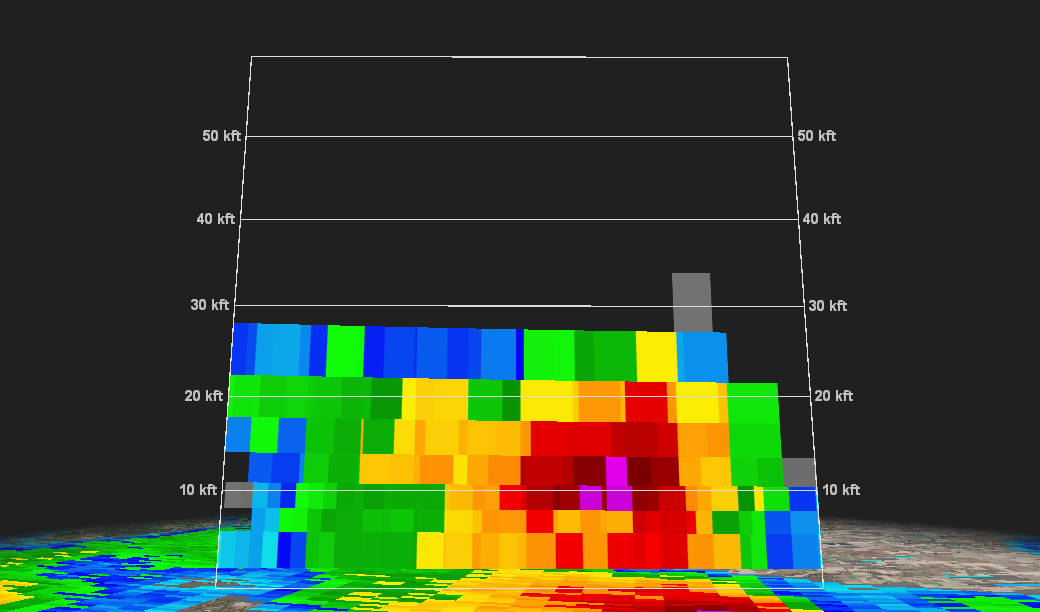 |
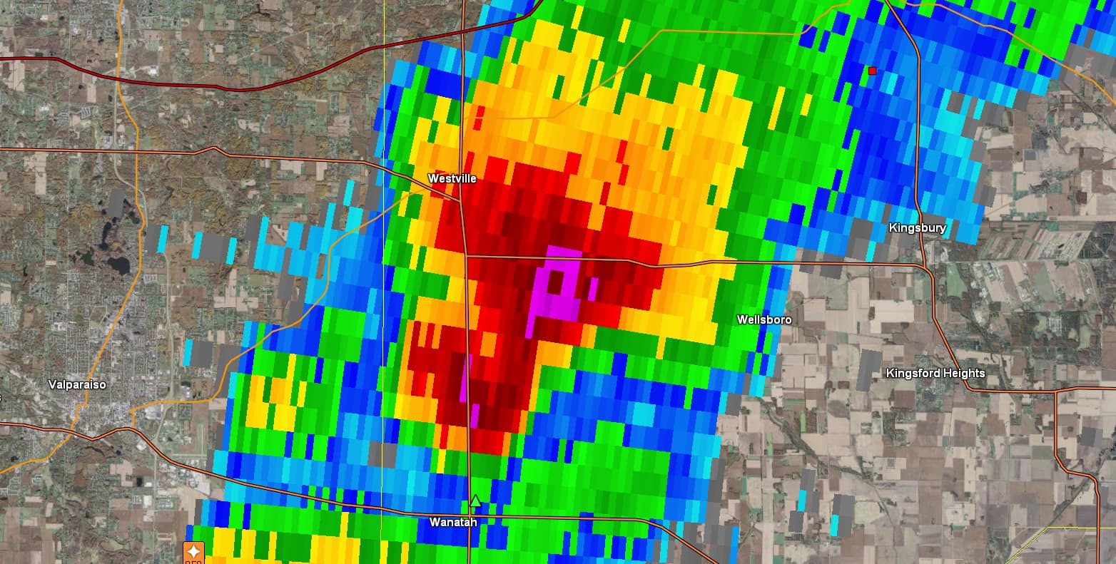
| 0.5 degree base reflectivity from KIWX at approximately 3:30pm EDT Thursday. This storm produced golf ball sized hail near Wanatah, IN | Vertical cross section of base reflectivity for same storm near Wanatah, IN indicating 50 dBZ returns higher than 20,000 feet above ground level. |
Storm Reports
PRELIMINARY LOCAL STORM REPORT...SUMMARY
NATIONAL WEATHER SERVICE NORTHERN INDIANA
332 AM EDT FRI MAR 15 2019

..TIME...   ...EVENT...      ...CITY LOCATION...     ...LAT.LON...
..DATE...   ....MAG....      ..COUNTY LOCATION..ST.. ...SOURCE....
            ..REMARKS..

1020 PM     NON-TSTM WND DMG 4 WSW BRISTOL           41.70N 85.89W
03/14/2019                   ELKHART            IN   BROADCAST MEDIA

            A TREE FELL ON A CAR ON STATE ROAD 120 JUST
            WEST OF COUNTY ROAD 17. NO INJURIES.

0753 PM     NON-TSTM WND DMG 1 NNW LINN GROVE        40.66N 85.04W
03/14/2019                   ADAMS              IN   DEPT OF HIGHWAYS

            POWER LINES DOWN ALONG SR 218 BETWEEN CR 500
            W AND SR 116.

0751 PM     NON-TSTM WND DMG 3 WNW NEW HAVEN         41.09N 85.08W
03/14/2019                   ALLEN              IN   BROADCAST MEDIA

            TREE DOWN BLOCKING THE ROAD.

0620 PM     HAIL             2 WNW ANGOLA            41.65N 85.03W
03/14/2019  M1.00 INCH       STEUBEN            IN   TRAINED SPOTTER


0615 PM     HAIL             SALEM CENTER            41.59N 85.14W
03/14/2019  E1.00 INCH       STEUBEN            IN   PUBLIC


0615 PM     HAIL             2 WNW ANGOLA            41.65N 85.03W
03/14/2019  E0.70 INCH       STEUBEN            IN   TRAINED SPOTTER


0542 PM     TSTM WND GST     3 NW SOUTH BEND         41.71N 86.31W
03/14/2019  M59 MPH          ST. JOSEPH         IN   ASOS

            WIND GUST RECORDED AT SOUTH BEND REGIONAL
            AIRPORT.

0542 PM     TSTM WND GST     2 WNW BENTON            41.52N 85.79W
03/14/2019  M59 MPH          ELKHART            IN   ASOS

            CORRECTS PREVIOUS TSTM WND GST REPORT FROM 3
            NW SOUTH BEND. WIND GUST RECORDED AT GOSHEN
            AIRPORT.

0449 PM     HAIL             3 WSW EDWARDSBURG       41.78N 86.14W
03/14/2019  E0.75 INCH       CASS               MI   TRAINED SPOTTER


0433 PM     TSTM WND DMG     1 E MARCELLUS           42.03N 85.78W
03/14/2019                   CASS               MI   BROADCAST MEDIA

            MULTIPLE TREES BLOWN DOWN EAST OF DOWAGIAC
            ALONG MARCELLUS HIGHWAY.

0433 PM     TSTM WND DMG     2 ENE DOWAGIAC          42.00N 86.08W
03/14/2019                   CASS               MI   BROADCAST MEDIA

            CORRECTS PREVIOUS TSTM WND DMG REPORT FROM 1
            E MARCELLUS. MULTIPLE TREES BLOWN DOWN EAST
            OF DOWAGIAC ALONG MARCELLUS HIGHWAY.

0426 PM     HAIL             3 ESE WEST UNITY        41.58N 84.39W
03/14/2019  M1.00 INCH       WILLIAMS           OH   TRAINED SPOTTER


0425 PM     HAIL             FAYETTE                 41.67N 84.33W
03/14/2019  E1.00 INCH       FULTON             OH   PUBLIC


0414 PM     HAIL             3 SSE PULASKI           41.47N 84.49W
03/14/2019  E0.88 INCH       WILLIAMS           OH   TRAINED SPOTTER

            TIME ESTIMATED BY RADAR.

0412 PM     HAIL             1 NNE SAINT JOSEPH      42.11N 86.48W
03/14/2019  E1.25 INCH       BERRIEN            MI   TRAINED SPOTTER

            TIME ESTIMATED BY RADAR.

0411 PM     HAIL             HUDSON LAKE             41.71N 86.53W
03/14/2019  E1.00 INCH       LA PORTE           IN   PUBLIC

            PICTURE SHARED ON TWITTER BY WSBT.

0410 PM     HAIL             1 SSW SAINT JOSEPH      42.08N 86.50W
03/14/2019  E1.25 INCH       BERRIEN            MI   PUBLIC

            LOTS OF SMALLER PIECES OF HAIL WITH A FEW TO
            HALF DOLLAR.

0410 PM     HAIL             FAIR PLAIN              42.08N 86.45W
03/14/2019  M0.88 INCH       BERRIEN            MI   TRAINED SPOTTER


0405 PM     HAIL             SAINT JOSEPH            42.10N 86.49W
03/14/2019  M0.75 INCH       BERRIEN            MI   TRAINED SPOTTER


0405 PM     HAIL             SAINT JOSEPH            42.10N 86.49W
03/14/2019  M1.00 INCH       BERRIEN            MI   TRAINED SPOTTER


0359 PM     HAIL             NEW CARLISLE            41.71N 86.51W
03/14/2019  E1.00 INCH       ST. JOSEPH         IN   BROADCAST MEDIA

            PICTURE SHARED ON TWITTER BY ABC 57.

0358 PM     HAIL             3 N KINGSBURY           41.57N 86.70W
03/14/2019  E1.75 INCH       LA PORTE           IN   PUBLIC

            BRIEF PERIOD OF HAIL WITH A FEW REACHING
            GOLF BALL SIZE.

0354 PM     TSTM WND GST     2 W BYRON               41.65N 86.66W
03/14/2019  E60 MPH          LA PORTE           IN   PUBLIC


0354 PM     HAIL             LA PORTE                41.60N 86.71W
03/14/2019  E0.70 INCH       LA PORTE           IN   BROADCAST MEDIA

            HAIL COVERING THE GROUND IN PARTS OF TOWN.

0354 PM     HAIL             2 W BYRON               41.65N 86.66W
03/14/2019  E1.25 INCH       LA PORTE           IN   PUBLIC


0352 PM     TSTM WND GST     3 NW SOUTH BEND         41.70N 86.31W
03/14/2019  M50 MPH          ST. JOSEPH         IN   ASOS

            REPORTED AT SOUTH BEND AIRPORT.

0335 PM     HAIL             WANATAH                 41.43N 86.90W
03/14/2019  E1.75 INCH       LA PORTE           IN   PUBLIC

            PICTURE POSTED ON TWITTER OF GOLF BALL SIZE
            HAIL.


&&

$$
Peak Wind Reports
Public Information Statement
National Weather Service Northern Indiana
454 AM EDT Fri Mar 15 2019

...PEAK WIND REPORTS PAST 24 HOURS...

Location                     Speed     Time/Date       Lat/Lon

...Indiana...

...Allen County...
Fort Wayne International Ap  54 MPH    1208 AM 03/15   40.98N/85.20W

...Cass County...
Logansport/cass Cnty Ap      51 MPH    0913 PM 03/14   40.71N/86.37W

...De Kalb County...
3 E Saint Johns              40 MPH    0135 AM 03/15   41.31N/85.06W

...Elkhart County...
2 WNW Benton                 59 MPH    0542 PM 03/14   41.52N/85.79W
Goshen Municipal Airport     59 MPH    0542 PM 03/14   41.53N/85.79W
Elkhart Municipal Airport    44 MPH    0550 PM 03/14   41.72N/86.00W
2 SW Simonton Lake           44 MPH    0550 PM 03/14   41.72N/86.00W
1 WNW Jimtown                36 MPH    0803 PM 03/14   41.64N/86.04W

...Fulton County...
Fulton County Airport        43 MPH    1235 AM 03/15   41.07N/86.18W

...Grant County...
Grant County Municipal Apt   41 MPH    0635 PM 03/14   40.48N/85.68W

...Huntington County...
3 SSW Huntington             46 MPH    0848 PM 03/14   40.83N/85.53W
3 NE Majenica                39 MPH    0723 PM 03/14   40.82N/85.41W

...Kosciusko County...
Warsaw Municipal Airport     48 MPH    0415 AM 03/15   41.27N/85.84W
James Lake                   42 MPH    1053 PM 03/14   41.31N/85.72W
2 SW Warsaw                  38 MPH    0446 PM 03/14   41.21N/85.87W
Warsaw Municipal Airport     38 MPH    0735 PM 03/14   41.27N/85.84W

...La Porte County...
2 W Byron                    60 MPH    0354 PM 03/14   41.65N/86.66W
La Porte                     49 MPH    0835 PM 03/14   41.57N/86.73W
Michigan City                43 MPH    0515 PM 03/14   41.70N/86.82W
1 W Michigan City            37 MPH    0742 PM 03/14   41.71N/86.90W

...Lagrange County...
1 ENE Lagrange               38 MPH    0601 PM 03/14   41.65N/85.39W

...Marshall County...
Plymouth                     39 MPH    1032 PM 03/14   41.34N/86.31W
Bremen                       38 MPH    0319 PM 03/14   41.44N/86.16W
2 W Mentone                  35 MPH    0303 PM 03/14   41.18N/86.08W

...Miami County...
1 SSW Grissom Afb            47 MPH    0520 PM 03/14   40.65N/86.15W
3 W Amboy                    42 MPH    0400 PM 03/14   40.59N/85.98W
Santa Fe                     38 MPH    1154 PM 03/14   40.64N/85.99W

...Noble County...
3 NE Avilla                  38 MPH    0655 PM 03/14   41.40N/85.20W

...Pulaski County...
3 ENE Vanmeter Park          42 MPH    0501 PM 03/14   41.11N/86.52W

...St. Joseph County...
3 W Roseland                 59 MPH    0542 PM 03/14   41.71N/86.31W
South Bend International Ap  51 MPH    1138 PM 03/14   41.71N/86.32W
2 S New Carlisle             46 MPH    0406 PM 03/14   41.66N/86.51W

...Starke County...
2 ESE Brems                  44 MPH    0435 PM 03/14   41.33N/86.66W

...Steuben County...
Tri-state Steuben County Air 40 MPH    0555 PM 03/14   41.64N/85.08W

...Wabash County...
1 SSE Roann                  55 MPH    0415 PM 03/14   40.89N/85.92W
Somerset                     41 MPH    0353 PM 03/14   40.66N/85.81W
2 ESE Somerset               37 MPH    0628 PM 03/14   40.66N/85.79W

...White County...
White County Arpt.           44 MPH    0415 PM 03/14   40.71N/86.77W

...Whitley County...
Columbia City                36 MPH    1045 PM 03/14   41.16N/85.49W

...Michigan...

...Berrien County...
1 SSE New Buffalo            50 MPH    0823 PM 03/14   41.77N/86.74W
Southwest Michigan Regional  48 MPH    0643 PM 03/14   42.13N/86.43W
1 WNW Millburg               42 MPH    0925 PM 03/14   42.13N/86.37W
Saint Joseph                 35 MPH    1116 AM 03/14   42.10N/86.49W

...Branch County...
3 ENE Lake of the Woods      44 MPH    0933 PM 03/14   41.88N/84.99W
Coldwater                    43 MPH    0636 PM 03/14   41.93N/85.05W

...Cass County...
2 WSW Edwardsburg            46 MPH    1102 PM 03/14   41.79N/86.13W

...Hillsdale County...
Hillsdale Municipal Airport  38 MPH    0156 AM 03/15   41.92N/84.59W
Jerome                       35 MPH    0209 AM 03/15   42.02N/84.46W

...St. Joseph County...
Three Rivers Municipal Dr Ha 51 MPH    0535 PM 03/14   41.96N/85.59W
1 S Constantine              49 MPH    1106 PM 03/14   41.82N/85.66W
Sturgis                      39 MPH    0355 PM 03/14   41.81N/85.44W

...Ohio...

...Allen County...
Lima Allen County Airport    48 MPH    0604 PM 03/14   40.71N/84.02W
Bluffton                     36 MPH    1035 AM 03/14   40.89N/83.89W

...Defiance County...
Defiance Memorial Airport    47 MPH    0448 PM 03/14   41.34N/84.43W

...Fulton County...
Fulton Cnty Ap               44 MPH    0120 AM 03/15   41.61N/84.13W

...Putnam County...
3 ENE Ottawa                 40 MPH    0435 PM 03/14   41.04N/83.98W
Kalida                       38 MPH    1032 PM 03/14   40.98N/84.20W

...Van Wert County...
Van Wert                     40 MPH    0428 PM 03/14   40.87N/84.59W
3 E Cavett                   38 MPH    0647 PM 03/14   40.95N/84.51W

...Williams County...
1 WSW Bryan                  39 MPH    0415 PM 03/14   41.46N/84.57W
2 WSW Hallock                36 MPH    0426 AM 03/15   41.51N/84.59W

Observations are collected from a variety of sources with varying
equipment and exposures. We thank all volunteer weather observers
for their dedication. Not all data listed are considered official.

$$
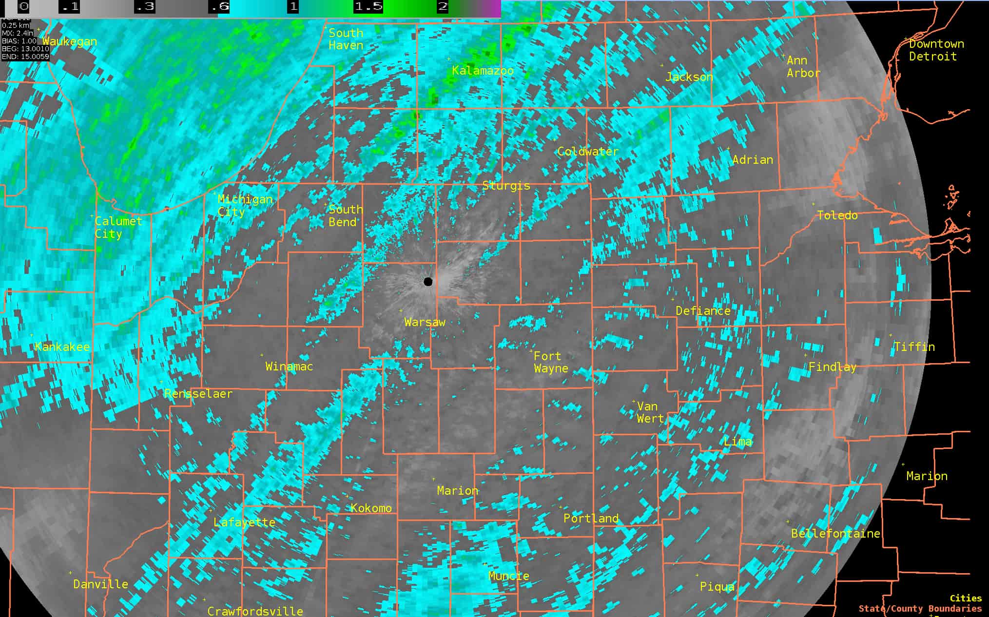
Rain Reports
The following may depicts radar estimated storm total rainfall. Rainfall amounts varied quite a bit across the area with swaths of a half inch to an inch of rain for locations which received the heavier showers and thunderstorms (especially southwest Lower Michigan).
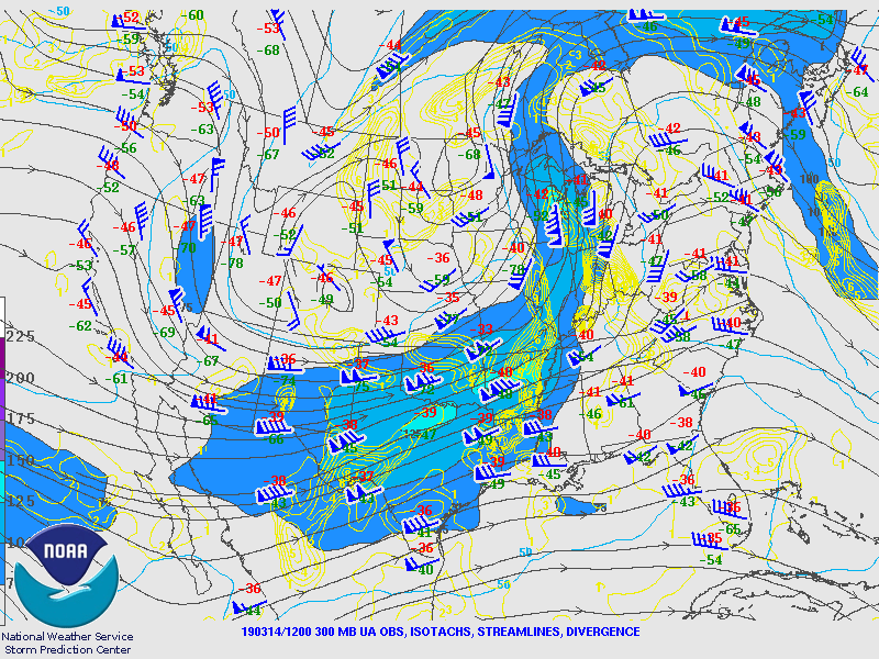
Environment
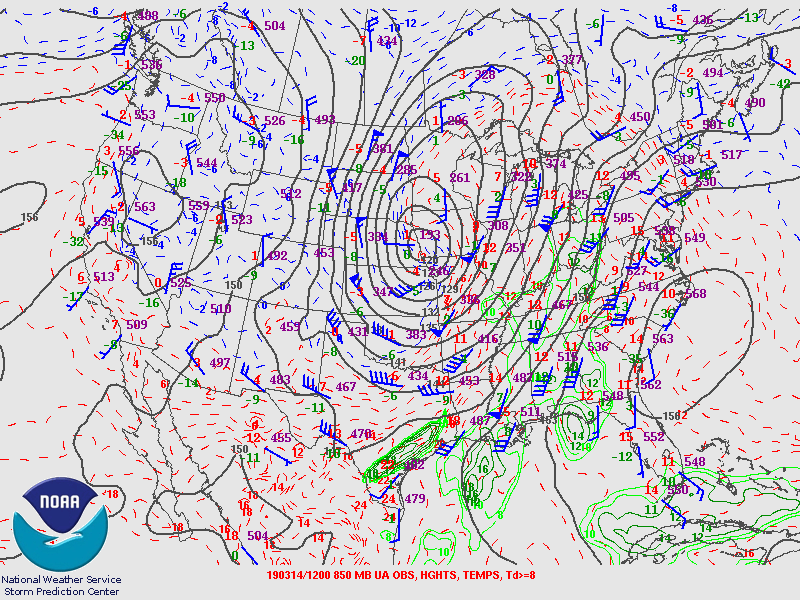
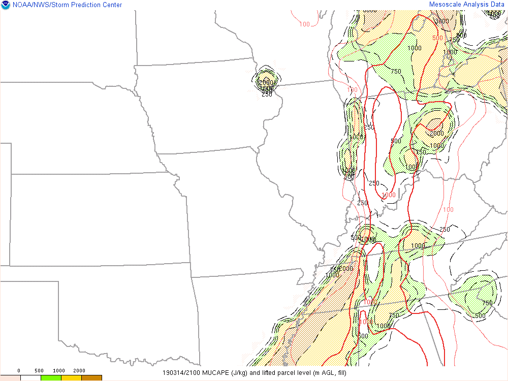
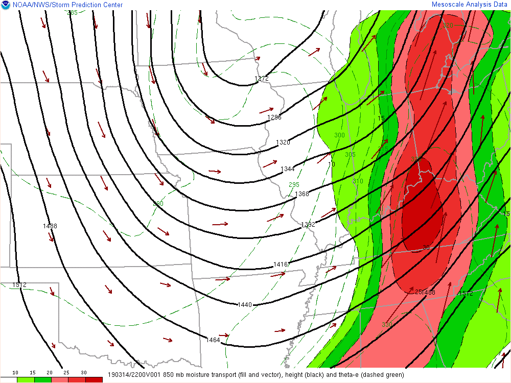
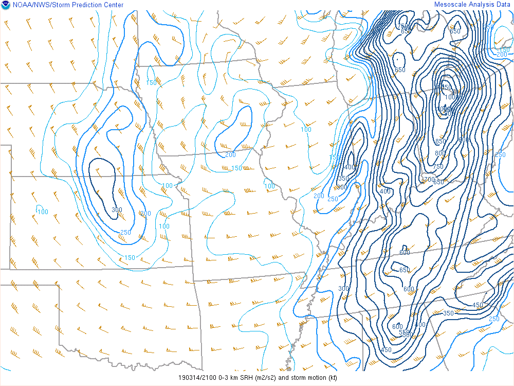
A strong upper level system was responsible for forcing thunderstorm development across the region during the afternoon and evening hours. Instability was limited and shear profiles were excessive. This hindered the severe weather potential across some locations. Areas across southwest Lower Michigan into far northwest Indiana experienced some of the stronger storms of this event at the nose of the weak instability axis where upper level forcing was maximized with an upper level jet streak, and where deep layer moisture convergence was maximized.
 |
 |
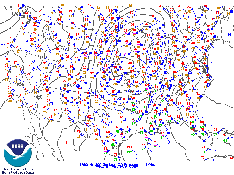 |
| Figure 1: 300 mb analysis from 8am 3/14/19 | Figure 2: 850 mb analysis from 8am 3/14/19 | Figure 3: Surface analysis from 8am 3/14/19 |
 |
 |
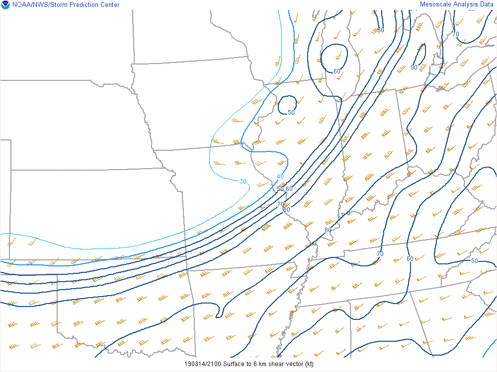 |
| Figure 4: Most Unstable CAPE (MUCAPE) analysis from 5pm 3/14/19. | Figure 5: Effective shear analysis from 5pm 3/14/19 | Figure 6: 0-6 km bulk shear analysis from 5pm 3/14/19 |
 |
 |
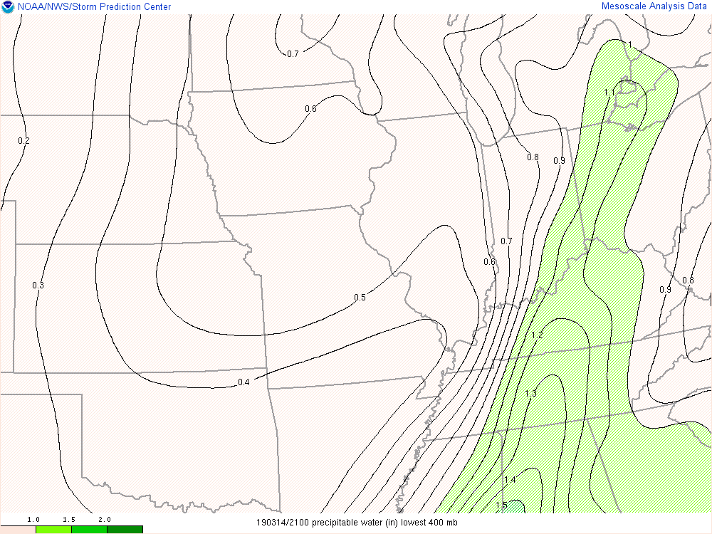 |
| Figure 7: 850 mb moisture transport analysis from 5pm 3/14/19 | Figure 8: 0-3 km storm relative helicity (SRH) from 5pm 3/14/19 | Figure 9: Precipitable water analysis from 5pm 3/14/19 |
 |
Media use of NWS Web News Stories is encouraged! Please acknowledge the NWS as the source of any news information accessed from this site. |
|

