New Orleans/Baton Rouge
Weather Forecast Office
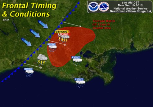
Severe Weather Event
|
| Location | Start/ End Time |
Event Type/ Max Winds |
Fatalities/ Injuries |
Path Length | Path Width |
| Walthall County 7 miles S of Tylertown, MS to 15 miles E of Tylertown, MS |
Monday 12/10 7:52 AM - 8:19 AM CST |
EF-1 Tornado 100 mph |
None | 17 miles | 100 yards |
| East Baton Rouge Parish 3.2 miles SW of Baker, LA to 2.2 miles ENE of Baker, LA |
Monday 12/10 6:48 PM - 6:57 PM CST |
EF-1 Tornado 105 mph |
None | 5.4 miles | 100 yards |
| Ascension Parish 3.8 miles N of Gonzales, LA to 3.9 miles N of Gonzales, LA |
Monday 12/10 8:50 AM - 8:54 AM CST |
EF-1 Tornado 90 mph |
None | 1.4 miles | 30 yards |
Current Hazards
Extended Outlooks
Outlooks
Fire Manager Quick Brief
Briefing Page
Storm Prediction Center
Forecasts
Marine Forecast
Activity Planner
River Forecasts
Tropical Forecast
Forecast Discussion
Aviation Weather Forecast
Graphical Forecast
Weather Models and Maps
Fire Weather Forecast
Hourly Weather Graph
Air Quality Forecasts
US Dept of Commerce
National Oceanic and Atmospheric Administration
National Weather Service
New Orleans/Baton Rouge
62300 Airport Rd.
Slidell, LA 70460-5243
504.522.7330 985.649.0429
Comments? Questions? Please Contact Us.