Hurricane Emily
Event Overview
Hurricane Emily was the fifth named storm, first hurricane, and only major hurricane of the 1993 Atlantic hurricane season. The tropical wave that spawned Emily moved off the West Coast of Africa on August 17, 1993 and into the Cape Verde Islands. Five days later, a tropical depression formed about 700 miles east-northeast of Puerto Rico. The system moved northwest for 2 days before encountering weak steering currents and becoming stationary as it began to intensify. A ridge eventually built north of Emily on August 26, causing the system to move toward the west while 900 miles east of Florida. After briefly becoming a hurricane on August 26, the storm fluctuated in intensity between a hurricane and a tropical storm as it moved west-northwest. As Emily rotated around the ridge, it moved more to the north. Intensification continued until late on August 31, when the hurricane clipped the Outer Banks as a Category 3 storm (Figures 1 and 2). Up to 10 feet of storm surge ran ashore on the Pamlico Sound side of Hatteras Island. The storm moved quickly away from the area and by September 2, it weakened to a tropical storm as it moved toward Bermuda and the Azores. Emily dissipated on September 6.
The National Weather Service office in Buxton, NC recorded a peak one-minute wind of 52 knots with a gust to 85 knots, but the measurement was disrupted just before the strongest winds are believed to have occurred. A private citizen in Buxton recorded 65 knots with a gust to 93 knots. These strong on-shore winds drove flood waters over the Sound side of Hatteras Island. The maximum rainfall recorded was 7.5 inches at Buxton with very little observed further west. Two swimming deaths in rough surf occurred at Nags Head, North Carolina on September 1. A preliminary damage estimate for North Carolina is $35 million dollars, mainly on Hatteras Island. There were 553 dwellings deemed uninhabitable. About 160,000 persons were evacuated from the barrier islands of North Carolina.
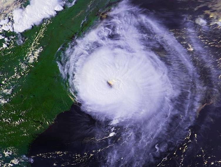
Figure 1. Category 3 Hurricane Emily moving near the Outer Banks, around 5 pm EDT on August 31, 1993
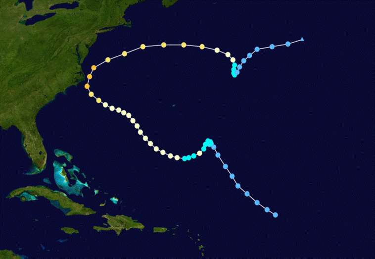
Figure 2. Track of Hurricane Emily, August 17 through September 6, 1993
Evolution and Impacts
Hurricane Emily moved across the Outer Banks as a Category 3 storm on the Saffir-Simpson scale on the evening of August 31, 1993. A portion of the western eye wall passed over Hatteras Island (Figure 3) and the surrounding waters, with one-minute surface winds estimated between 65 and 100 knots. Analysis at the Hurricane Research Division, indicated surface winds speeds as high as 100 knots over Pamlico Sound. This caused strong on-shore winds on the Pamlico Sound side of Hatteras Island and the accompanying storm surge coastal flooding was as high as 10.2 feet above normal tide levels at Buxton, NC. The flooding was made worse by high astronomical tides. There were reports of cars “floating” in several parking lots in Buxton. In numerous homes, waist-high waves broke through windows and surged into living rooms. The flooding was one to two feet higher than predicted on one-hundred-year flood maps, resulting in the need for revised flood-mapping for Hatteras Island. The Atlantic coast maximum surge levels are estimated to be only 1 to 2 feet above normal.
There were Hurricane Watches posted from North Carolina to Delaware at 5 pm EDT August 29, or about 47 hours prior to the closest approach of the hurricane. A Hurricane Warning was issued at 200 pm EDT August 30, or 26 hours prior to the closest approach of the cyclone.
In Eastern North Carolina, Hurricane Emily damaged 553 homes beyond repair. In addition, officials cut power to Hatteras Island, due to fears that downed power lines could start a fire. The area hardest hit by Emily in North Carolina was the city of Buxton, with storm surge, along with a rainfall amounts of 7.5 inches. There were reports of sinkholes on Highway 12 due to heavy rains produced by the storm, some of which swallowed up three four-wheel-drive vehicles. Because Emily hit during Labor Day weekend, the tourism industry suffered after Emily, losing $10,000,000 (1993 US Dollars) when 160,000 were evacuated from Eastern North Carolina. Emily's storm surge and ensuing flooding left 25% of the people of Cape Hatteras homeless, which caused Dare County to issue a federal disaster declaration. Emily's strong winds uprooted trees, downed power lines, tore the roofs off of some homes, and combined with its flooding, caused $35,000,000 (1993 US Dollars) in damage. Emily only caused 2 deaths in North Carolina, which occurred when two swimmers drowned in Nags Head. The low death toll can likely be attributed to the massive evacuations of the area.
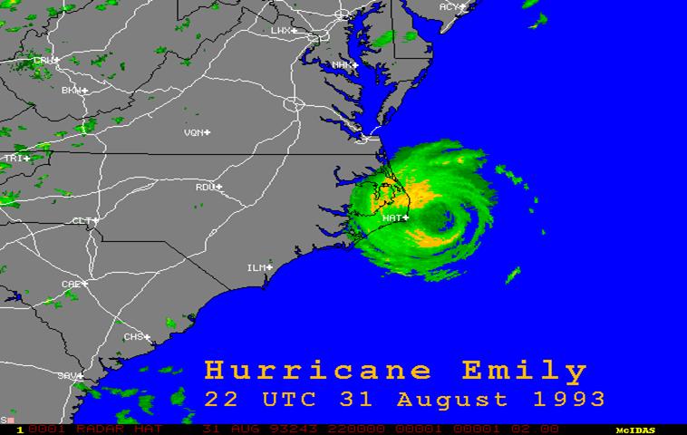
Figure 3. Western eyewall of Hurricane Emily over the Outer Banks at around 6 pm EDT, August 31, 1993 (photo courtesy University of Wisconsin)
Sources
National Hurricane Center
National Centers for Environmental Prediction
University of Wisconsin
North Carolina’s Hurricane History by Jay Barnes (Third Edition)
Photos


Case Review Team:
Chris Collins


 Map View
 Weather Hazard Briefing (when applicable)
 Forecaster Discussion
 Marine
 Text Products
.png) Skywarn
Skywarn Submit Storm Reports
 Coastal Flood
.png) Surf Forecast/Rip Currents
Surf Forecast/Rip Currents