(be sure to scroll down for a survey on how you use our Frost/Freeze Products)

Growing season status as of November 19th, 2020.
A widespread frost and freeze occurred over much of Eastern North Carolina on the morning of November 19th, 2020, therefore the growing season has ended for most of the area. The exception is over the Outer Banks. The season here will end on November 25th unless a freeze occurs before that date.
Using the tabs below scroll through for more information and graphics.
Low Temps
The image below shows that most of Eastern North Carolina saw temperatures near freezing with widespread frost. Areas farther away from the warming effects of the water experienced a hard freeze with temperatures as low as the upper 20s. Below the map is a list of minimum temperatures observed in our area.
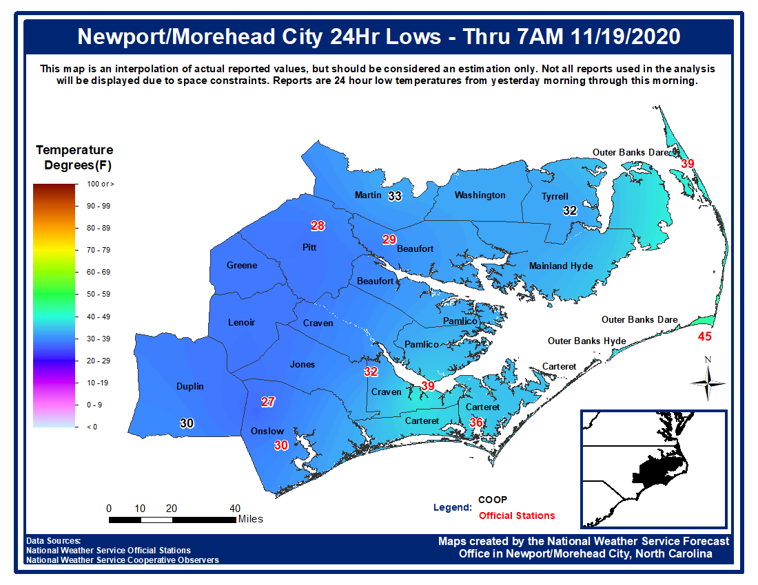
Low Temperatures (11/19/2020)
000 NOUS42 KMHX 191306 PNSMHX NCZ029-044>047-079>081-090>092-094-193>196-198-199-203>205-200106- PUBLIC INFORMATION STATEMENT NATIONAL WEATHER SERVICE NEWPORT/MOREHEAD CITY NC 806 AM EST THU NOV 19 2020 ...LOW TEMPERATURE REPORTS... LOCATION TEMP TIME/DATE PROVIDER ...NORTH CAROLINA... ...BEAUFORT COUNTY... BUNYAN RAWS 29 F 0513 AM 11/19 RAWS WASHINGTON (OCW AWOS) 29 F 0515 AM 11/19 AWOS BELHAVEN 30 F 0417 AM 11/19 CWOP ...CARTERET COUNTY... NEWPORT 28 F 0446 AM 11/19 CWOP CROATAN RAWS 28 F 0205 AM 11/19 RAWS NEWPORT 29 F 0432 AM 11/19 CWOP BEAUFORT 30 F 0402 AM 11/19 CWOP NEWPORT 30 F 0301 AM 11/19 CWOP NEWPORT 31 F 1236 AM 11/19 CWOP CAPE CARTERET 32 F 0501 AM 11/19 CWOP NEWPORT 33 F 0246 AM 11/19 CWOP MOREHEAD CITY 33 F 0145 AM 11/19 CWOP NEWPORT 34 F 0135 AM 11/19 CWOP BOGUE FIELD (NJM ASOS) 34 F 0657 AM 11/19 AWOS ...CRAVEN COUNTY... GENESEO 29 F 0730 AM 11/19 CWOP NEW BERN RAWS 30 F 0617 AM 11/19 RAWS 3 S HAVELOCK 32 F 0700 AM 11/19 AWS 1 SSW JAMES CITY 33 F 0720 AM 11/19 AWS TRENT WOODS 33 F 0727 AM 11/19 CWOP HAVELOCK 34 F 0650 AM 11/19 CWOP ...DARE COUNTY... DARE CO GNRY RAN (2DP AWOS) 29 F 0656 AM 11/19 AWOS DARE BOMB RANGE RAWS 35 F 0528 AM 11/19 RAWS ...DUPLIN COUNTY... WILLIAMSDALE FIELD LAB 28 F 0610 AM 11/19 NC-ECONET WARSAW 30 F 0710 AM 11/19 CWOP ...HYDE COUNTY... 4 NE ENGELHARD 36 F 0755 PM 11/18 AWOS FAIRFIELD RAWS 36 F 0817 PM 11/18 RAWS ...LENOIR COUNTY... KINSTON (ISO AWOS) 28 F 0656 AM 11/19 AWOS CUNNINGHAM RESEARCH STATION 30 F 0605 AM 11/19 NC-ECONET SEVEN SPRINGS 32 F 0716 AM 11/19 CWOP ...MARTIN COUNTY... HIGHWAY PATROL COMM STATION 28 F 0615 AM 11/19 NC-ECONET ...ONSLOW COUNTY... RICHLANDS (OAJ AWOS) 27 F 0656 AM 11/19 AWOS JACKSONVILLE 7.0 W 28 F 0621 AM 11/19 CWOP JACKSONVILLE 28 F 0622 AM 11/19 CWOP JACKSONVILLE 28 F 0600 AM 11/19 CWOP HOFFMAN RAWS 28 F 0710 AM 11/19 RAWS SANDY RUN RAWS 29 F 0519 AM 11/19 RAWS HOLLY RIDGE 30 F 0535 AM 11/19 CWOP JACKSONVILLE (NCA ASOS) 30 F 0656 AM 11/19 AWOS ...PAMLICO COUNTY... BAYBORO 31 F 0325 AM 11/19 AWS ...PITT COUNTY... GREENVILLE (PGV AWOS) 28 F 0635 AM 11/19 AWOS GREENVILLE 29 F 0604 AM 11/19 CWOP 3 WNW WINTERVILLE 30 F 0755 AM 11/19 CWOP DOWDY FICKLEN STADIUM (WEATH 35 F 0700 AM 11/19 MESOWEST ...WASHINGTON COUNTY... POCOSIN LAKES RAWS 28 F 0417 AM 11/19 RAWS TIDEWATER RESEARCH STATION 29 F 0650 AM 11/19 NC-ECONET CRESWELL 32 F 0530 AM 11/19 CWOP ...MARITIME STATIONS... ORIENTAL 32 F 0633 AM 11/19 CWOP && OBSERVATIONS ARE COLLECTED FROM A VARIETY OF SOURCES WITH VARYING EQUIPMENT AND EXPOSURES. WE THANK ALL VOLUNTEER WEATHER OBSERVERS FOR THEIR DEDICATION. NOT ALL DATA LISTED ARE CONSIDERED OFFICIAL. $$ |
Climatology
While some areas experienced some patchy frost earlier in the month, this was the first widespread freeze for most of the area. From the graphic below our median date for the first freeze in the fall is November 11th. The frost/freeze program ends either when we have a hard widespread freeze or when we are two weeks past our median freeze date (November 25th).
PNS
The growing season has ended for most of Eastern NC as of November 19th. It will end on November 25th over the Outer Banks unless we experience a freeze before then.
Growing Season Statement (11/19/2020)
000 NOUS42 KMHX 192021 CCA PNSMHX NCZ029-044>047-079>081-090>092-094-193>196-198-199-203>205-200000- PUBLIC INFORMATION STATEMENT...CORRECTED NATIONAL WEATHER SERVICE NEWPORT/MOREHEAD CITY NC 700 AM EST THU NOV 19 2020 ...THE GROWING SEASON HAS ENDED FOR ALL OF MAINLAND EASTERN NORTH CAROLINA... WITH THE EXCEPTION OF THE OUTER BANKS, FREEZING TEMPERATURES THROUGH THE OVERNIGHT AND EARLY MORNING HOURS HAS ENDED THE GROWING SEASON FOR EASTERN NORTH CAROLINA. THEREFORE, FROST AND FREEZE HEADLINES WILL NOT BE ISSUED AGAIN UNTIL THE GROWING SEASON BEGINS IN THE SPRING OF 2021. FOR THE OUTER BANKS, IF FREEZING TEMPERATURES ARE NOT OBSERVED BY NOVEMBER 25TH, THE FROST AND FREEZE PROGRAM WILL AUTOMATICALLY BE TERMINATED. $$ |
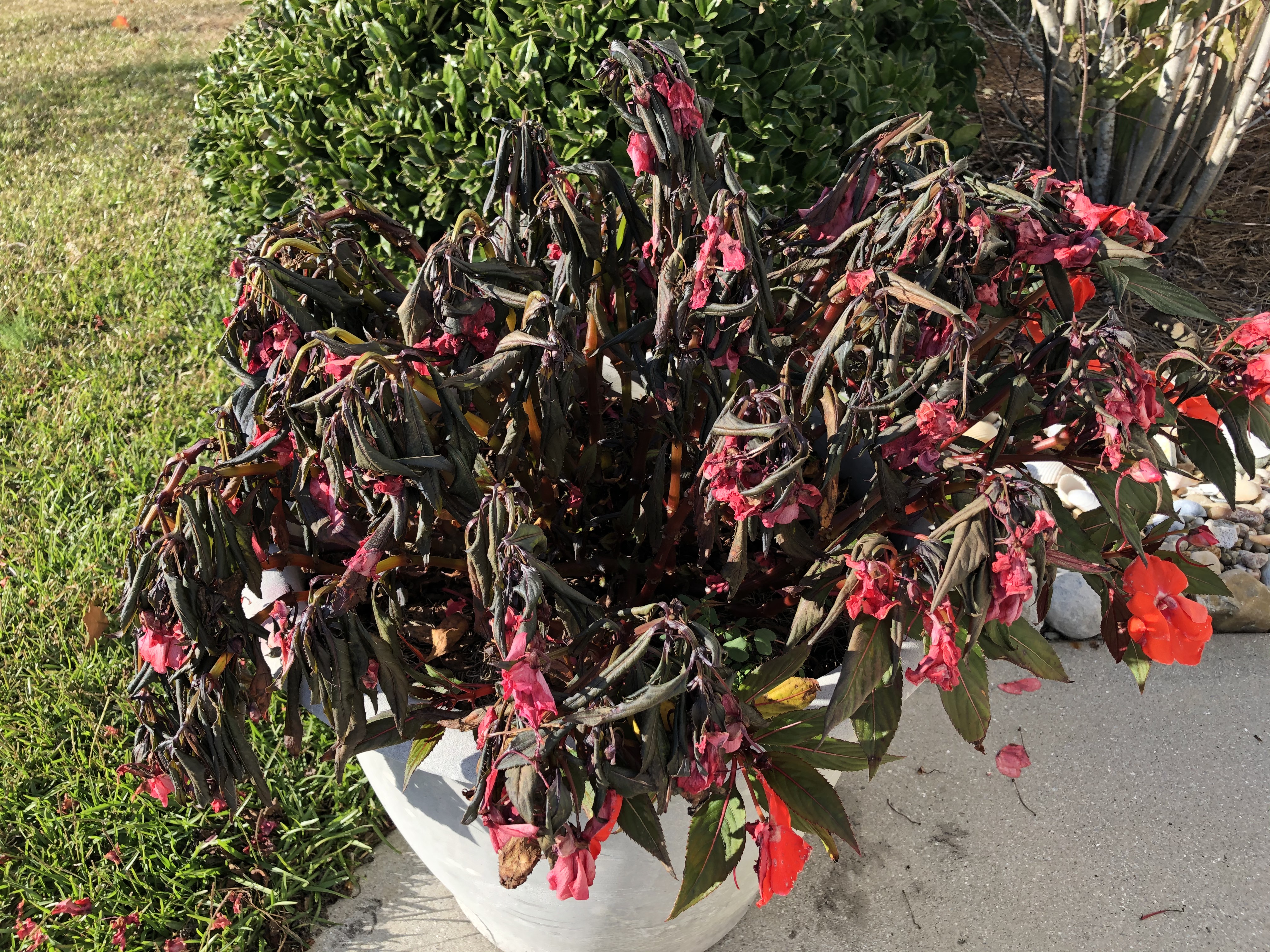
Pictures
|
An example of what happens if you don't bring in tender vegetation or flowers prior to a hard freeze. This New Guinea Impatiens is an annual and after temperatures in the upper 20s did not make it. Credit: Erik Heden |
Survey
We would love to know how you use our Frost and Freeze Products! Here is a public information statement about our survey with the actual survey located here. The survey is open through December 17th, 2020.


.png) Surf Forecast/Rip Currents
Surf Forecast/Rip Currents Map View
 Weather Hazard Briefing (when applicable)
 Forecaster Discussion
 Marine
 Text Products
.png) Skywarn
Skywarn Submit Storm Reports
 Coastal Flood