Hurricane Bertha
Event Overview
Hurricane Bertha was an early season Cape Verde hurricane that started from a tropical wave that moved off the African Coast on July 1st. It was the first hurricane of the 1996 season and the first major hurricane in July since the 1926 season. It quickly progressed on a west-northwest track over the Virgin Islands before turning north-northwest and just missing Puerto Rico. It reached its peak intensity on July 9th with maximum wind speeds of 115 mph and a minimum pressure of 960 mb. Eventually the storm would turn on a north-northeast track and make landfall between Wrightsville and Topsail Beach, NC as a Category 2 hurricane on July 12th (Fig. 1).
Hurricane Bertha caused a total of twelve deaths both directly and indirectly ranging from auto accidents to drowning. Bertha also caused an estimated $250-$270 million in damages and 125,000 people evacuated from North and South Carolina, and Georgia resulting in a $40 million deficit in the tourism industry.
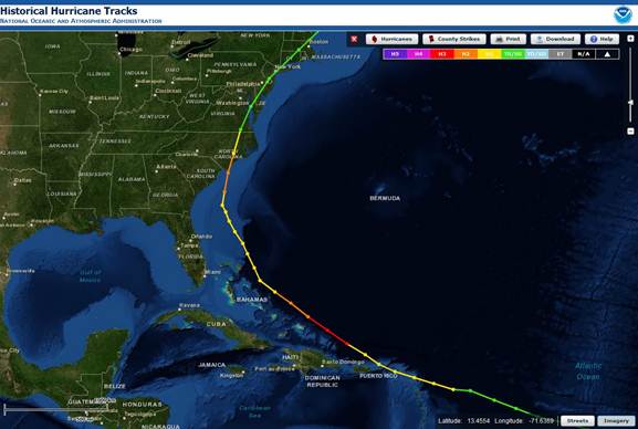
Figure 1: Track of Hurricane Bertha (Coastal Services Center).
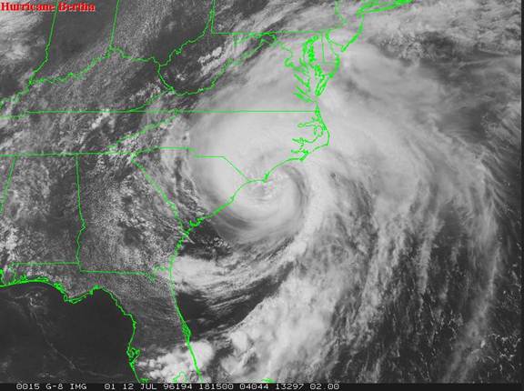
Figure 2. Visible Satellite Image of Hurricane Bertha shortly before landfall on July 12th. (NCDC)
Development and Impacts –
Hurricane Bertha formed from a tropical wave that moved off the coast of Africa on July 1st. By 8 p.m. July 5th, satellite imagery indicated the storm had developed into a Tropical Depression. Soon after, the depression would be upgraded to a Tropical Storm by 8 a.m. July 6th, progressing quickly on a west-northwesterly track at about 23-29 mph. For the next few days, the storm continued on this path, steered by a strong Atlantic high pressure system located over the central Atlantic. During this time, the storm underwent gradual intensification and by 2 p.m. on the 7th, the Tropical Storm was upgraded to Hurricane status with maximum sustained winds of 75 knots (86 mph).
The first of many places to feel the impact of Hurricane Bertha would be the Leeward and Virgin Islands. The center moved between Antigua and Barbuda on 2 a.m. July 8th and eventually across St. Martin, just north of St. Thomas, and over the British Virgin Islands by 2 p.m. on the same day. These areas observed hurricane conditions resulting in moderate to severe damage. Boats were destroyed, homes were damaged, and one man suffered injuries from riding out the storm in his sailboat. Total damages were estimated around $7.5 million.
As the storm continued on, the track turned to a slower more northwesterly path, moving around 17-22 mph. Bertha experienced a period of rapid intensification while it was located 138 miles north of Puerto Rico. At 2 a.m. July 9th, the hurricane reached its peak intensity. The maximum sustained wind speeds were 100 knots (115 mph) with a minimum pressure of 960 mb, making Bertha a Category 3 hurricane for a brief period. Considering the strongest part of the hurricane was in the northeast quadrant, Puerto Rico only suffered Tropical Storm conditions. General rainfall amounts averaged 1-3 inches with and isolated maximum of 6.89 inches located on the northeast corner of Puerto Rico.
The hurricane weakened for another brief period as it turned more north-northwesterly, paralleling the Bahamas, and slowing its course to about 9 mph over the 10th and 11th. Wind speeds decreased to Category 1 status (74-95 mph) as the storm continued moving north-northwest parallel to the Florida and Georgia coastlines, remaining 170-200 miles off shore Fig. 3.
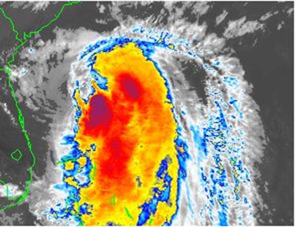
Figure 3. July 11th, 11:15 a.m. Bertha as a Category 1 storm before undergoing a period of rapid intensification. (NCDC)
As the center of the storm approached the South Carolina coast, the track turned more north-northeast and accelerated to about 17 mph. As the storm headed for the North Carolina coast, Bertha underwent another period of rapid intensification just 12 hours before landfall. The storm’s wind speeds went from a Category 1 status to Category 2, with maximum sustained wind speeds of 104 mph (Fig. 4).
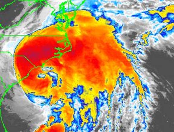
Figure 4. July 12th, 12:15 p.m. Bertha as a Category 2 storm four hours before landfall. Much better organization after rapid intensification from crossing the Gulf Stream. (NCDC)
At 4 p.m. July 12th, Hurricane Bertha finally made landfall between Wrightsville and Topsail Beaches in North Carolina. Maximum sustained winds were 90 knots (104 mph) with a minimum pressure of 974 mb at landfall. Hurricane Bertha quickly lost strength after it made landfall and continued moving northeast along the US coast. Forty to fifty knot sustained winds were reported over land from northern North Carolina to New England. By 8 a.m. July 14th the system was declared extratropical and was tracked until 8 p.m. July 16th where it had passed Greenland.
Although Hurricane Bertha caused damage from the Virgin Islands to Puerto Rico and from Florida all the way up through New England, the most extensive damage occurred in North Carolina. Twelve deaths total were reported to be related in some way to Bertha. Two of those were in North Carolina where one death was from a car accident and the other had drowned in rip currents. The Virgin Islands and North Carolina were declared federal disaster areas and there were 750,000 people evacuated in North Carolina alone. Rainfall totals throughout eastern NC varied from 1-7 inches. Heavier accumulations reported towards the coastline where totals ranged from 3-5 inches with isolated reports of 7+ inches. The maximum rainfall measured was 9.20 inches located at Southport 5N, NC (Fig. 5). Majority of the damage in coastal North Carolina was a result of coastal flooding. Coastal storm surge ranged from 1-4 ft. from Florida to New England, with reported values of up to 5 ft. in North Carolina. A storm surge of 6 ft. was indicated near Swansboro, NC. Coastal erosion was prevalent along the coast, specifically to beach dunes and coastal roads. The sand dunes in Emerald Isle had 8-10 ft. vertical drops. Fifty feet of land was washed away from Mason Inlet. Numerous houses were damaged not only from strong winds, but also from beach erosion.
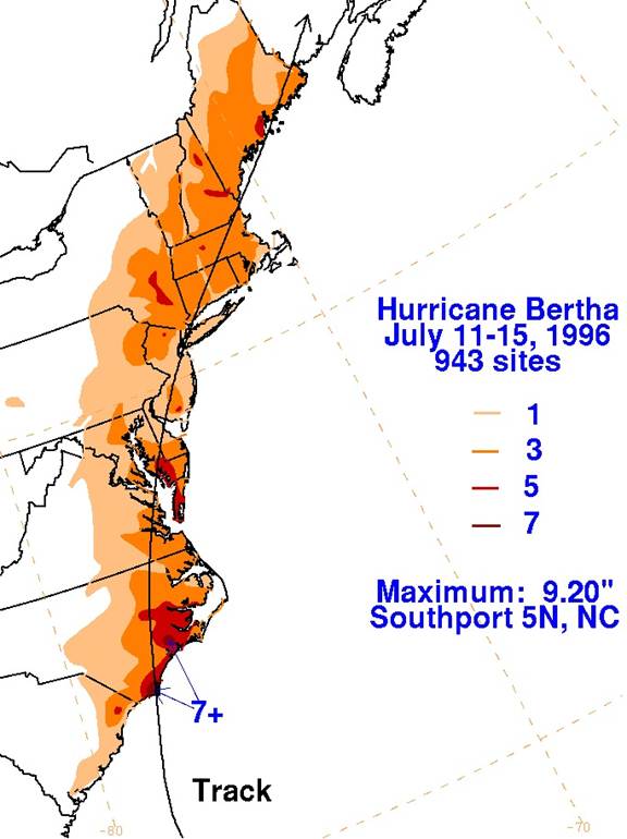
Figure 5. Rainfall totals from Bertha (HPC)
Agricultural damage was extensive due to long exposure to the Northeast winds before landfall, with damage cost in just three counties alone estimated to be $21 million. The highest wind gust reported on land occurred at Camp Lejeune in Jacksonville, NC at a speed of 108 mph. The most intense wind damage was located between North Topsail Beach and Emerald Isle, NC. Initially there were six reports of tornado touchdowns in Eastern NC. However, during an aerial survey, it was determined that only one report could be verified. The track was identified from this survey and was estimated to last 1.5 miles and rated as an F-1 tornado. Most of the damage in Virginia was a result of tornadic storms associated with Bertha. Rainfall totals in coastal Virginia and Maryland Shores ranged from 3-6 inches with 2-4 inches reported throughout inland Virginia. The western shore of the Chesapeake Bay reported 4-4.5 inches while inland Maryland/D.C. area only had amounts in the 1-2.5 range. Coastal Jersey generally reported 2-4 inches with isolated reports of 6+ inches. Coastal New York claimed 1-3 inches with isolated reports of 4+ inches. The New England area generally had 2-4 inches with isolated reports of 5+ inches. Most of the coast from Virginia to New England only suffered minor coastal flooding. Between North Carolina, Virginia, and South Carolina, the American Insurance Association reports an estimated $135 million in insured property losses, with the majority being $100 million in North Carolina.
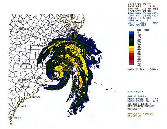
Figure 6. MHX Radar image one hour after landfall (NCDC)
The path of destruction left by Hurricane Bertha was devastating. It left thousands without power for several days up and down the east coast, cost millions of dollars in damage, claimed twelve lives, nearly washed away dunes and piers, and robbed the tourist industry of millions of dollars. Hurricane Bertha was the first of four significant hurricanes that would make landfall in the late 1990’s.
Sources-
NCDC Bertha Images
NCDC Bertha Discussion
Case Study Team:
Misty Duncan
David Glenn


 Map View
 Weather Hazard Briefing (when applicable)
 Forecaster Discussion
 Marine
 Text Products
.png) Skywarn
Skywarn Submit Storm Reports
 Coastal Flood
.png) Surf Forecast/Rip Currents
Surf Forecast/Rip Currents