What changes are being made?
WFO Melbourne will be splitting the Public and Fire Weather Forecast Zones for Brevard, Indian River, Saint Lucie and Martin Counties into separate coastal and inland sections. The coastal zone boundary in Volusia County will be adjusted to match with surrounding zone boundaries in Flagler and Brevard Counties.
Why are these changes being made?
This effort is to support narrower, smaller coastal public/fire zones intended for the Wireless Emergency Alerts (WEA) for storm surge, and more targeted messaging/alerting for coastal flood, rip current, high wind, cold weather, and fire weather products. This change will bring WFO Melbourne into alignment with all other Florida WFOs, which have distinct coastal and inland zones for all of their coastal counties.
Weather conditions can vary significantly between the immediate coast, barrier islands, intracoastal waterway, and mainland areas west of US Highway 1, Interstate 95, and the Florida Turnpike. The division of coastal zones will provide increased forecaster flexibility and improved forecast accuracy for fire weather products, which are frequently utilized by local fire partners.
When will these changes go into effect?
These changes will be implemented on April 5, 2022 at 4 PM Eastern Daylight Time (EDT), 2000 Coordinated Universal Time (UTC). If there is severe weather on the planned date, then the backup date will be postponed to another date.
Are these changes normal?
Yes, local NWS offices reconfigure both Public and Fire Weather Zones to enhance forecasts for public and partner use.
These changes are intended to provide increased flexibility and improved accuracy of forecast and various watches, warnings and advisories in the public and fire weather programs.
IMPORTANT: The Fire and Public Zone changes require partners and users to take appropriate action to receive the new Zone products using the Universal Generic Code (UGC) zone code format (Z). The list of new zone codes can be found below for each county. Please note that the zone codes for Volusia will remain the same. These changes will not impact the output on NOAA Weather Radio stations in Daytona Beach, Orlando, Melbourne, and Fort Pierce. All required configurations will be handled by NWS Melbourne and no action is required by weather radio listeners.
WFO Melbourne Products Affected By Zone Changes
The following products will be affected by the changes in coastal public and fire weather forecast zones:
Product Name WMO Heading AWIPS ID
------------------- -------------------- --------------
Hurricane Local Statement WTUS82 KMLB HLSMLB
Tropical Cyclone Watch/Warning WTNT81 KNHC TCVAT1-5
Coastal Hazard Message WHUS42 KMLB CFWMLB
Surf Zone Forecast FZUS52 KMLB SRFMLB
Fire Weather Forecast FNUS52 KMLB FWFMLB
Fire Weather Message WWUS82 KMLB RFWMLB
Fire Danger Statement FNUS62 KMLB RFDMLB
Zone Forecast FPUS52 KMLB ZFPMLB
Point Forecast Matrices OUS52 KMLB PFMMLB
Tabular State Forecast FPUS62 KMLB SFTMLB
Tsunami Message WEXX20 PAAQ TSUAT1
Public Info Statement NOUS42 KMLB PNSMLB
Non-Precipitation Warnings WWUS72 KMLB NPWMLB
Flood Watch WGUS62 KMLB FFAMLB
Special Weather Statement WWUS82 KMLB SPSMLB
Winter Weather Message WWUS42 KMLB WSWMLB
Area Forecast Discussion FXUS62 KMLB AFDMLB
Hydrologic Outlook FGUS72 KMLB ESFMLB
Additional information is available in the following NWS Public Information Statement:
NWS Public Information Statement (PNS)
Overview of Changes
Below are descriptions and maps showing the current and new zone configurations for our coastal counties.
Volusia County
What is changing: In Volusia County, the zone configuration for Coastal Volusia (FLZ141) and Inland Volusia (FLZ041) will remain the same, as the only change is the eastward movement of the boundary line between the two zones. The new boundary will become Interstate 95 from the Volusia-Brevard County line north to the junction of Interstate 95 and Interstate 4. From this junction a line will be drawn north to match the zone boundary NWS Jacksonville has in Flagler County.
Zone Codes: No Change for Volusia
The zone codes for current Coastal Volusia (FLZ141) and Inland Volusia (FLZ041) zones will remain the same, as the only change is the eastward movement of the boundary line between the two zones.
Brevard County
What is changing: In Brevard County, both the Northern Brevard (FLZ147) and Southern Brevard (FLZ047) zones will each be split into three zones: inland, mainland, and barrier island. Interstate 95 will be the dividing line between the inland and mainland zones, and the Intracoastal Waterway will divide the mainland and barrier island zones. Additionally, State Road 528 and State Road A1A from Canaveral Groves to Port Canaveral will serve as the new boundary between northern and southern zones.
Zone Codes: Significant Change for Brevard
The current Northern Brevard (FLZ147) and Southern Brevard (FLZ047) zones will become:
Inland Northern Brevard (FLZ247)
Mainland Northern Brevard (FLZ347)
Northern Brevard Barrier Islands (FLZ447)
Inland Southern Brevard (FLZ547)
Mainland Southern Brevard (FLZ647)
Southern Brevard Barrier Islands (FLZ747)
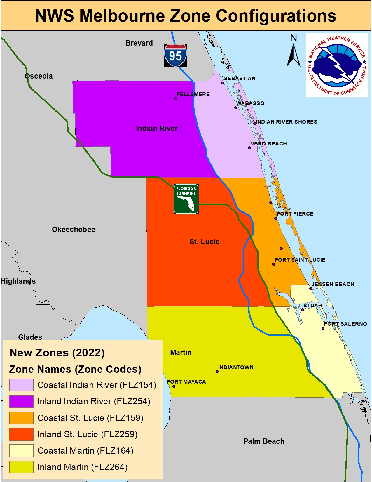
Indian River County
What is changing: In Indian River County, the new zones will be split along Interstate 95.
Zone Codes: Change for Indian River
The current Indian River (FLZ054) zone will become: Coastal Indian River (FLZ154) and Inland Indian River (FLZ254).
Saint Lucie County
What is changing: In Saint Lucie County, the new zones will be split along a combination of Interstate 95 and the Florida Turnpike. From north to south, Interstate 95 is used from the Indian River-Saint Lucie County line south to the junction of Interstate 95 and the Florida Turnpike. From there southward, the Turnpike will be the dividing line.
Zone Codes: Change for Saint Lucie
The current Saint Lucie (FLZ059) zone will become: Coastal Saint Lucie (FLZ159) and Inland Saint Lucie (FLZ259).
Martin County
What is changing: In Martin County, the new zones will be split along the Florida Turnpike.
Zone Codes: Change for Martin
The current Martin (FLZ064) zone will become: Coastal Martin (FLZ164) and Inland Martin (FLZ264).
Figure 1 below shows the current 2021 zone configurations for Volusia and Brevard Counties.
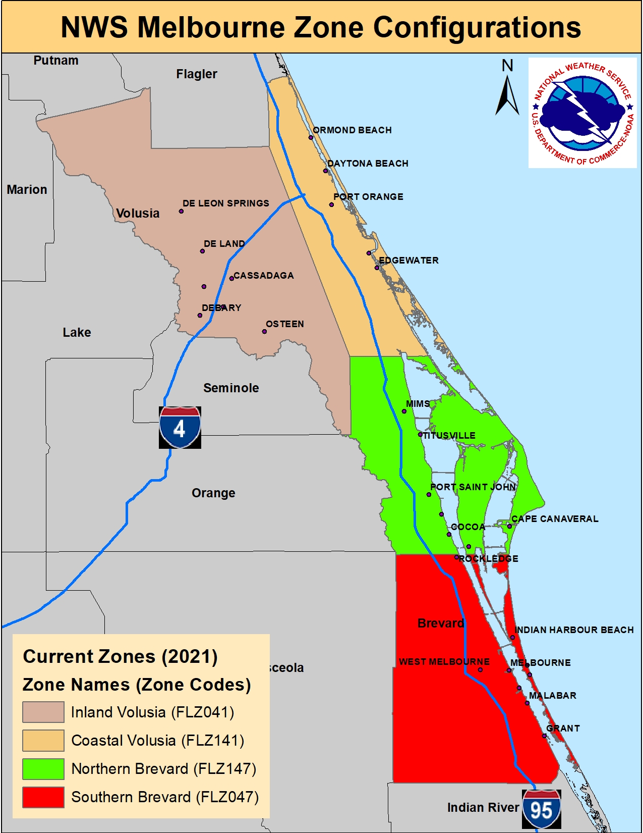
Figure 2 below shows the new 2022 zone configurations for Volusia and Brevard Counties.
Figure 3 below shows the current 2021 zone configurations for Indian River, St. Lucie, and Martin Counties.

Figure 4 below shows the new 2022 zone configurations for Indian River, St. Lucie, and Martin Counties.