Melbourne, FL
Weather Forecast Office
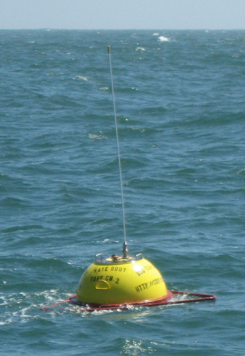
Nearshore Buoy Information
In September 2006, the U.S. Army Corp of Engineers deployed two wave monitoring buoys. Fort Pierce Buoy (CDIP #134, NOAA #41114) is approximately 6 nautical miles northeast of the Fort Pierce Inlet (27.5526 N, 80.2196 W, 56ft depth) and the Cape Canaveral Buoy (CDIP #143, NOAA #41113) is approximately 3 nautical miles east of the Cape Canaveral channel entrance (28.4000 N, 80.5333 W, 33ft depth).
 Hourly, these buoys report wave height, wave period, wave direction and sea surface temperature to the National Weather Service, who in turn broadcasts the information on NOAA Weather Radio. This wave data is useful to coastal mariners and provides an important safety component to recreational as well as commercial boaters.
At night time, these buoys emit a yellow color, Coast Guard compliant, flashing light from the top of the antenna (about 9.5 feet above the sea surface).
Over the years, these buoys have been hit numerous times by vessels, costing thousands of dollars in repairs. In order to assure that these buoys do not lose funding someday, please help publicize their location to other mariners so that damage can be mitigated. Also, never tie up to these (or any) buoys while fishing!
These buoys are deployed and maintained by the Coastal Data Information Program (CDIP) at the Scripps Institution of Oceanography in La Jolla , CA .
CURRENT HAZARDS
Hazardous Weather Outlook (Graphical)
Florida Hazards (CAP Text)
Outlooks
Storm Reports (Text)
Storm Reports (Graphical)
Cold Weather Support
FORECASTS
Area Forecast Discussion
Aviation Weather
Fire Weather
Graphical
Marine Weather
Probabilistic
Text Products
Tropical Weather
Winter Probabilistic
CURRENT WEATHER
Local Analysis
Observations
Precip Analysis
Satellite Images
Rivers/Lakes
RADAR IMAGERY
Melbourne Standard
Melbourne Enhanced
Regional - Southeast
Area Radars
US Dept of Commerce
National Oceanic and Atmospheric Administration
National Weather Service
Melbourne, FL
421 Croton Road
Melbourne, FL 32935
321-255-0212
Comments? Questions? Please Contact Us.

