Overview
Heavy snow moved out of South Dakota and into southern Minnesota during the morning of January 18th. Eventually, a band of intense snowfall setup during the afternoon between I-90 and Mankato, where snowfall amounts up to 12.5" (Mapleton) were reported. There was a fairly sharp gradient in snowfall totals to the north as a very cold and dry arctic airmass in northern Minnesota limited how far north the snow could make it, with snowfall on the day basically confined to areas south of I-94.
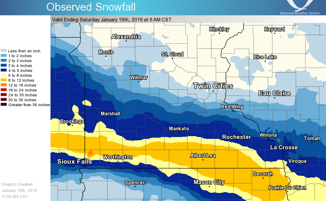
Snowfall Reports
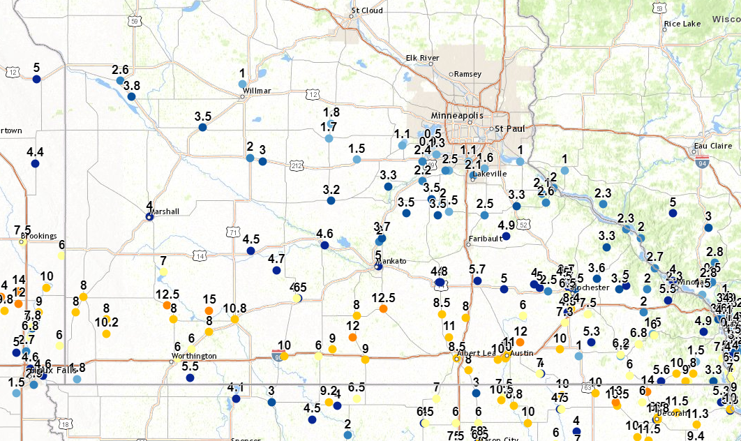
...SNOWFALL REPORTS...

Location                     Amount
Mapleton                     12.5 in
Winnebago                    12.0 in
3 NNE Manchester             11.0 in
Albert Lea                   10.5 in
Sherburn                     10.0 in
Granada                      9.0 in
Blue Earth                   9.0 in
Sherburn                     8.5 in
New Richland                 8.5 in
Albert Lea                   8.5 in
Amboy                        8.0 in
Glenville                    8.0 in
Ellendale                    8.0 in
8 NE Myrtle                  7.0 in
St. James                    6.0 in
Fairmont                     6.0 in
Albert Lea                   6.0 in
Owatonna                     5.7 in
Mankato                      5.0 in
Redwood Falls                5.0 in
Nerstrand 4E                 4.9 in
Waseca                       4.8 in
Sveadahl 5NNW                4.7 in
New Ulm 3SE                  4.6 in
St. James                    4.5 in
Springfield 1NW              4.5 in
Albert Lea                   4.0 in
Waseca                       4.0 in
Mankato                      4.0 in
St. Peter 6WSW               4.0 in
Montevideo                   4.0 in
Dawson                       4.0 in
Milan 1NW                    3.8 in
St. Peter                    3.7 in
New Prague                   3.5 in
Montgomery 3ENE              3.5 in
Faribault                    3.5 in
Canby                        3.5 in
Clara City                   3.5 in
Le Center 5NNW               3.5 in
Bird Island 7SSE             3.4 in
Cannon Falls                 3.3 in
6 N Henderson                3.3 in
Winthrop                     3.2 in
Mankato                      3.0 in
Bird Island                  3.0 in
1 N Appleton                 2.6 in
Vasa 3ENE                    2.6 in
8 NE Myrtle                  2.5 in
1 ENE Northfield             2.5 in
Carver 1W                    2.4 in
Stockholm 2NE                2.3 in
Jordan 1SW                   2.2 in
Lakeville                    2.1 in
Vasa 5NNE                    2.1 in
Mankato                      2.0 in
Olivia                       2.0 in
1 SW St. Peter               2.0 in
Prior Lake 1WSW              2.0 in
Veseli 1W                    2.0 in
Red Wing                     2.0 in
Hutchinson 5N                1.8 in
Hutchinson                   1.7 in
Lakeville                    1.6 in
Apple Valley 3ESE            1.6 in
Lonsdale                     1.5 in
Prior Lake                   1.5 in
Glencoe 3NW                  1.5 in
Glencoe                      1.5 in
8 NE Myrtle                  1.3 in
Shakopee                     1.3 in
Victoria 1WSW                1.3 in
Burnsville                   1.1 in
Waconia                      1.1 in
Mankato                      1.0 in
Willmar 5N                   1.0 in
2 WSW Ellsworth              1.0 in
Hastings (L/D 2)             1.0 in
Chaska                       0.9 in
1 SW Chanhassen              0.5 in

Observations are collected from a variety of sources with varying
equipment and exposures. We thank all volunteer weather observers
for their dedication. Not all data listed are considered official.
Radar
Radar evolution of the snow shield from 12:00 PM CST January 18, 2019 through 6:00 PM CST January 18, 2019.



 Follow us on X
 Follow us on Facebook
 Follow us on YouTube
 MPX RSS Feed