Overview
|
Light to moderate snow spread into the area during the afternoon hours on Saturday, December 10th, and continued into the afternoon hours of the following day, Sunday, December 11th. An enhanced band of snowfall developed around the Interstate 90 corridor late Saturday evening, and gradually shifted northeast to Interstate 94 by early Sunday morning. Snowfall rates of up to 1 inch per hour were common in this band. The snow was light and fluffy, but winds were not that strong and this limited any significant blowing or drifting. |
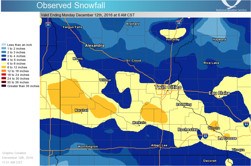 December 10-11, 2016 Snowfall |
Radar:
|
Radar Loop 1030 AM Sat-Noon Sunday |
Storm Reports
PRELIMINARY LOCAL STORM REPORT...SUMMARY NATIONAL WEATHER SERVICE TWIN CITIES/CHANHASSEN MN 752 PM CST SUN DEC 11 2016 ..TIME... ...EVENT... ...CITY LOCATION... ...LAT.LON... ..DATE... ....MAG.... ..COUNTY LOCATION..ST.. ...SOURCE.... ..REMARKS.. 0730 PM SNOW MOUNDS VIEW 45.11N 93.21W 12/11/2016 M6.8 INCH RAMSEY MN PUBLIC . 0700 PM SNOW 1 WSW VICTORIA 44.86N 93.68W 12/11/2016 M8.0 INCH CARVER MN COCORAHS 1.6 MILES WSW OF VICTORIA. 0600 PM SNOW CHANHASSEN 44.86N 93.56W 12/11/2016 M9.1 INCH CARVER MN OFFICIAL NWS OBS STORM TOTAL SNOWFALL . 0600 PM SNOW 3 E RICHFIELD 44.88N 93.22W 12/11/2016 M7.1 INCH HENNEPIN MN OFFICIAL NWS OBS . 0600 PM SNOW 6 E ST. CLOUD 45.54N 94.05W 12/11/2016 M3.5 INCH SHERBURNE MN OFFICIAL NWS OBS . 0520 PM SNOW ALTOONA 44.80N 91.45W 12/11/2016 M4.3 INCH EAU CLAIRE WI COCORAHS COCORAHS STATION ALTOONA /WI-EC-5/. 0504 PM SNOW 3 SSW ALTOONA 44.76N 91.46W 12/11/2016 M4.5 INCH EAU CLAIRE WI OFFICIAL NWS OBS REPORTED AT WQOW TV. 0450 PM SNOW COKATO 45.08N 94.19W 12/11/2016 M6.0 INCH WRIGHT MN PUBLIC . 0445 PM SNOW FRIDLEY 45.08N 93.26W 12/11/2016 M5.5 INCH ANOKA MN PUBLIC NEAR MOORE LAKE. 0423 PM SNOW HAUGEN 45.61N 91.78W 12/11/2016 M4.0 INCH BARRON WI TRAINED SPOTTER . 0350 PM SNOW BLAINE 45.17N 93.21W 12/11/2016 M5.0 INCH ANOKA MN TRAINED SPOTTER . 0345 PM SNOW 1 WNW GOLDEN VALLEY 44.99N 93.37W 12/11/2016 M6.9 INCH HENNEPIN MN PUBLIC . 0340 PM SNOW 3 E PRINCETON 45.57N 93.53W 12/11/2016 M3.3 INCH MILLE LACS MN COCORAHS . 0324 PM SNOW RED WING 44.58N 92.60W 12/11/2016 M6.8 INCH GOODHUE MN PUBLIC . 0315 PM SNOW 2 WSW MINNEAPOLIS 44.95N 93.30W 12/11/2016 M5.8 INCH HENNEPIN MN NWS EMPLOYEE MEASURED BY UPTOWN METEOROLOGIST. 0255 PM SNOW BOYCEVILLE 45.05N 92.04W 12/11/2016 M6.3 INCH DUNN WI PUBLIC . 0220 PM SNOW 2 NNW EAGAN 44.85N 93.18W 12/11/2016 M7.1 INCH DAKOTA MN PUBLIC . 0211 PM SNOW 1 SE CHASKA 44.81N 93.60W 12/11/2016 M8.5 INCH CARVER MN COCORAHS WESTERN PORTION OF CITY. 0100 PM SNOW 2 NNE LAKEVILLE 44.71N 93.23W 12/11/2016 M7.5 INCH DAKOTA MN COCORAHS COCORAHS STATION LAKEVILLE 2NNE /MN-DK-73/. 0100 PM SNOW 1 SE ST. LOUIS PARK 44.94N 93.35W 12/11/2016 M6.0 INCH HENNEPIN MN TRAINED SPOTTER . 0100 PM SNOW 4 N VICTORIA 44.92N 93.66W 12/11/2016 M6.0 INCH HENNEPIN MN PUBLIC MEASURED IN ORONO, MN. 1234 PM SNOW VESTA 44.51N 95.41W 12/11/2016 M8.0 INCH REDWOOD MN CO-OP OBSERVER . 1230 PM SNOW 2 SW PRIOR LAKE 44.71N 93.46W 12/11/2016 M6.9 INCH SCOTT MN COCORAHS COCORAHS STATION PRIOR LAKE 1WSW /MN-SC-2/. 1200 PM SNOW NORTHFIELD 44.46N 93.16W 12/11/2016 M8.5 INCH RICE MN PUBLIC . 1200 PM SNOW WINSTED 44.97N 94.05W 12/11/2016 M6.5 INCH MCLEOD MN PUBLIC . 1200 PM SNOW CAMBRIDGE 45.56N 93.23W 12/11/2016 M2.5 INCH ISANTI MN TRAINED SPOTTER . 1130 AM SNOW 1 NNW NORTH ST. PAUL 45.03N 93.01W 12/11/2016 M5.3 INCH RAMSEY MN COCORAHS COCORAHS STATION NORTH ST PAUL 1NNW /MN-RM-2/. 1115 AM SNOW 3 NNW RICHFIELD 44.92N 93.30W 12/11/2016 M7.0 INCH HENNEPIN MN PUBLIC . 1115 AM SNOW MAPLE PLAIN 45.01N 93.66W 12/11/2016 M6.7 INCH HENNEPIN MN TRAINED SPOTTER . 1100 AM SNOW 3 NE MORRISTOWN 44.25N 93.40W 12/11/2016 E9.5 INCH RICE MN PUBLIC . 1100 AM SNOW EDEN PRAIRIE 44.85N 93.46W 12/11/2016 M8.0 INCH HENNEPIN MN PUBLIC . 1100 AM SNOW WACONIA 44.85N 93.80W 12/11/2016 M7.3 INCH CARVER MN NWS EMPLOYEE . 1100 AM SNOW 1 W DELANO 45.04N 93.81W 12/11/2016 M7.0 INCH WRIGHT MN TRAINED SPOTTER . 1100 AM SNOW 3 WSW ST. PAUL 44.93N 93.17W 12/11/2016 M7.0 INCH RAMSEY MN PUBLIC . 1100 AM SNOW 1 SE EDINA 44.88N 93.34W 12/11/2016 M6.5 INCH HENNEPIN MN PUBLIC . 1100 AM SNOW 2 WNW ST. PAUL 44.96N 93.15W 12/11/2016 M6.3 INCH RAMSEY MN PUBLIC . 1100 AM SNOW 1 SSW ROBERTS 44.97N 92.56W 12/11/2016 M5.0 INCH ST. CROIX WI CO-OP OBSERVER CO-OP OBSERVER STATION ROBERTS /ROBW3/. 1100 AM SNOW SHERBURN 43.65N 94.73W 12/11/2016 M5.0 INCH MARTIN MN PUBLIC . 1100 AM SNOW ROGERS 45.19N 93.55W 12/11/2016 M4.0 INCH HENNEPIN MN TRAINED SPOTTER . 1045 AM SNOW SACRED HEART 44.79N 95.35W 12/11/2016 M10.0 INCH RENVILLE MN TRAINED SPOTTER . 1045 AM SNOW 2 E BLOOMINGTON 44.83N 93.27W 12/11/2016 E7.0 INCH HENNEPIN MN PUBLIC . 1045 AM SNOW 1 N MAPLE GROVE 45.12N 93.46W 12/11/2016 M5.7 INCH HENNEPIN MN COCORAHS COCORAHS STATION MAPLE GROVE 1N /MN-HN-31/. 1030 AM SNOW 1 E FARIBAULT 44.30N 93.25W 12/11/2016 M9.5 INCH RICE MN PUBLIC . 1030 AM SNOW 1 N NORTHFIELD 44.47N 93.16W 12/11/2016 M9.0 INCH RICE MN PUBLIC . 1030 AM SNOW 5 SW LONG LAKE 44.94N 93.64W 12/11/2016 M7.5 INCH HENNEPIN MN PUBLIC . 1030 AM SNOW 2 NE MONTROSE 45.09N 93.88W 12/11/2016 M5.8 INCH WRIGHT MN PUBLIC . 1015 AM SNOW MAPLE GROVE 45.11N 93.46W 12/11/2016 M6.5 INCH HENNEPIN MN PUBLIC . 1015 AM SNOW FOLEY 45.67N 93.91W 12/11/2016 M3.0 INCH BENTON MN TRAINED SPOTTER . 1012 AM SNOW 2 NW LAKEVILLE 44.70N 93.28W 12/11/2016 M7.0 INCH DAKOTA MN TRAINED SPOTTER . 1000 AM SNOW MONTGOMERY 44.44N 93.58W 12/11/2016 E11.0 INCH LE SUEUR MN PUBLIC . 1000 AM SNOW FARMINGTON 44.66N 93.18W 12/11/2016 E7.5 INCH DAKOTA MN PUBLIC . 1000 AM SNOW 2 ENE EDINA 44.90N 93.32W 12/11/2016 M7.2 INCH HENNEPIN MN COCORAHS COCORAHS STATION EDINA 2 ENE /MN-HN-125/. 1000 AM SNOW BURNSVILLE 44.77N 93.28W 12/11/2016 M6.5 INCH DAKOTA MN TRAINED SPOTTER . 1000 AM SNOW PLYMOUTH 45.02N 93.46W 12/11/2016 E5.8 INCH HENNEPIN MN PUBLIC . 1000 AM SNOW 2 N ST. PAUL 44.98N 93.11W 12/11/2016 M5.6 INCH RAMSEY MN PUBLIC . 1000 AM SNOW 3 NW LAKELAND 44.97N 92.82W 12/11/2016 M5.5 INCH WASHINGTON MN COCORAHS COCORAHS STATION LAKELAND 2WNW /MN-WG-46/. 1000 AM SNOW 1 SW COON RAPIDS 45.16N 93.33W 12/11/2016 M5.3 INCH ANOKA MN COCORAHS COCORAHS STATION COON RAPIDS 1 SW /MN-AA-59/. 1000 AM SNOW ALBERT LEA 43.65N 93.36W 12/11/2016 M5.0 INCH FREEBORN MN BROADCAST MEDIA . 1000 AM SNOW 3 SSW ALTOONA 44.76N 91.46W 12/11/2016 M4.3 INCH EAU CLAIRE WI OFFICIAL NWS OBS . 1000 AM SNOW ANNANDALE 45.26N 94.12W 12/11/2016 M4.0 INCH WRIGHT MN PUBLIC . 1000 AM SNOW 3 NW DONNELLY 45.72N 96.06W 12/11/2016 M2.7 INCH STEVENS MN COCORAHS COCORAHS STATION DONNELLY 2WNW /MN-SV-4/. 0950 AM SNOW DURAND 44.63N 91.96W 12/11/2016 E5.0 INCH PEPIN WI PUBLIC . 0945 AM SNOW 2 W NEW PRAGUE 44.55N 93.61W 12/11/2016 M8.3 INCH SCOTT MN PUBLIC . 0945 AM SNOW 3 SSW ALTOONA 44.76N 91.46W 12/11/2016 M4.3 INCH EAU CLAIRE WI OFFICIAL NWS OBS SNOW DEPTH: 6". 0940 AM SNOW 4 NW ONAMIA 46.11N 93.74W 12/11/2016 M1.3 INCH MILLE LACS MN COCORAHS COCORAHS STATION ONAMIA 4WNW /MN-ML-1/. 0930 AM SNOW GRANITE FALLS 44.81N 95.54W 12/11/2016 E10.0 INCH YELLOW MEDICINE MN PUBLIC . 0930 AM SNOW CANBY 44.71N 96.27W 12/11/2016 E8.5 INCH YELLOW MEDICINE MN PUBLIC . 0930 AM SNOW 1 SW SHAKOPEE 44.76N 93.49W 12/11/2016 M8.5 INCH SCOTT MN TRAINED SPOTTER . 0930 AM SNOW 1 N ST. PETER 44.35N 93.96W 12/11/2016 M8.0 INCH NICOLLET MN PUBLIC . 0930 AM SNOW WOODBURY 44.92N 92.94W 12/11/2016 M5.3 INCH WASHINGTON MN PUBLIC . 0915 AM SNOW 1 NNW HEWITT 46.34N 95.09W 12/11/2016 M1.8 INCH TODD MN COCORAHS COCORAHS STATION HEWITT 1NNW /MN-TD-4/. 0908 AM SNOW 3 ESE EDEN PRAIRIE 44.83N 93.40W 12/11/2016 M7.1 INCH HENNEPIN MN COCORAHS COCORAHS STATION EDEN PRAIRIE 3SE /MN-HN-86/. 0900 AM SNOW 1 SW EDINA 44.88N 93.38W 12/11/2016 M6.7 INCH HENNEPIN MN COCORAHS SNOW WATER EQUIVALENT: 0.41". 0900 AM SNOW MENOMONIE 44.88N 91.91W 12/11/2016 M5.5 INCH DUNN WI PUBLIC . 0900 AM SNOW 3 ESE MINNEAPOLIS 44.95N 93.22W 12/11/2016 M5.5 INCH HENNEPIN MN COCORAHS COCORAHS STATION MINNEAPOLIS 2 ESE /MN-HN-169/. 0900 AM SNOW 2 ESE HAM LAKE 45.25N 93.16W 12/11/2016 M4.9 INCH ANOKA MN COCORAHS COCORAHS STATION HAM LAKE 2E /MN-AA-31/. 0900 AM SNOW 4 S CLEAR LAKE 45.19N 92.28W 12/11/2016 M3.5 INCH ST. CROIX WI COCORAHS COCORAHS STATION CLEAR LAKE 4 S /WI-SC-21/. 0900 AM SNOW 2 E PRINCETON 45.57N 93.55W 12/11/2016 M2.7 INCH MILLE LACS MN PUBLIC STILL SNOWING LIGHTLY. 0900 AM SNOW 7 NNW SWANVILLE 46.00N 94.70W 12/11/2016 M2.0 INCH TODD MN COCORAHS COCORAHS STATION SWANVILLE 6NW /MN-TD-7/. 0858 AM SNOW 1 SW EDINA 44.88N 93.38W 12/11/2016 M6.7 INCH HENNEPIN MN COCORAHS COCORAHS STATION EDINA 1SW /MN-HN-19/. 0848 AM SNOW SAVAGE 44.76N 93.35W 12/11/2016 M7.0 INCH SCOTT MN PUBLIC . 0845 AM SNOW OWATONNA 44.09N 93.23W 12/11/2016 M7.0 INCH STEELE MN PUBLIC . 0845 AM SNOW WATERTOWN 44.96N 93.85W 12/11/2016 M6.7 INCH CARVER MN NWS EMPLOYEE . 0830 AM SNOW NEW ULM 44.31N 94.46W 12/11/2016 E8.5 INCH BROWN MN PUBLIC ESTIMATED 8-9". 0830 AM SNOW 2 NE EDEN PRAIRIE 44.86N 93.43W 12/11/2016 M7.0 INCH HENNEPIN MN BROADCAST MEDIA SNOWFALL AT KMSP-TV. 0830 AM SNOW FARIBAULT 44.30N 93.28W 12/11/2016 M7.0 INCH RICE MN PUBLIC . 0830 AM SNOW DARWIN 45.10N 94.40W 12/11/2016 M6.0 INCH MEEKER MN TRAINED SPOTTER . 0830 AM SNOW ST. PAUL 44.94N 93.10W 12/11/2016 M5.8 INCH RAMSEY MN PUBLIC . 0830 AM SNOW LONG LAKE 44.98N 93.57W 12/11/2016 M5.7 INCH HENNEPIN MN COCORAHS COCORAHS STATION LONG LAKE /MN-HN-6/. 0830 AM SNOW ST. LOUIS PARK 44.95N 93.37W 12/11/2016 M5.5 INCH HENNEPIN MN TRAINED SPOTTER . 0830 AM SNOW 2 WNW OSSEO 45.13N 93.43W 12/11/2016 M5.3 INCH HENNEPIN MN COCORAHS COCORAHS STATION OSSEO 1 W /MN-HN-150/. 0830 AM SNOW COMFREY 44.11N 94.90W 12/11/2016 M5.0 INCH BROWN MN PUBLIC . 0830 AM SNOW WHITE BEAR LAKE 45.07N 93.01W 12/11/2016 M5.0 INCH RAMSEY MN PUBLIC . 0829 AM SNOW 1 NE STILLWATER 45.07N 92.81W 12/11/2016 M5.0 INCH WASHINGTON MN COCORAHS COCORAHS STATION STILLWATER 1NE /MN-WG-20/. 0822 AM SNOW 2 SW LAKEVILLE 44.66N 93.28W 12/11/2016 M6.0 INCH DAKOTA MN COCORAHS COCORAHS STATION LAKEVILLE 2WSW /MN-DK-49/. 0811 AM SNOW MAPLE PLAIN 45.01N 93.66W 12/11/2016 M6.5 INCH HENNEPIN MN TRAINED SPOTTER . 0800 AM SNOW CANBY 44.72N 96.27W 12/11/2016 M10.0 INCH YELLOW MEDICINE MN CO-OP OBSERVER CO-OP OBSERVER STATION CANBY /CANM5/. 0800 AM SNOW 6 NNW LE CENTER 44.47N 93.77W 12/11/2016 M9.0 INCH LE SUEUR MN COCORAHS COCORAHS STATION LE CENTER 5NNW /MN-LS-12/. 0800 AM SNOW PINE ISLAND 44.21N 92.65W 12/11/2016 M9.0 INCH GOODHUE MN PUBLIC . 0800 AM SNOW KENYON 44.27N 92.98W 12/11/2016 M8.0 INCH GOODHUE MN TRAINED SPOTTER . 0800 AM SNOW MADISON 45.02N 96.19W 12/11/2016 M8.0 INCH LAC QUI PARLE MN PUBLIC . 0800 AM SNOW 3 SE CHANHASSEN 44.83N 93.52W 12/11/2016 M7.5 INCH HENNEPIN MN COCORAHS COCORAHS STATION CHANHASSEN 2SE /MN-HN-17/. 0800 AM SNOW 3 NE VICTORIA 44.89N 93.61W 12/11/2016 M7.5 INCH CARVER MN COCORAHS COCORAHS STATION VICTORIA 2ENE /MN-CV-27/. 0800 AM SNOW 3 SSE MINNEAPOLIS 44.92N 93.25W 12/11/2016 M7.0 INCH HENNEPIN MN COCORAHS COCORAHS STATION MINNEAPOLIS 2 SSE /MN-HN-99/. 0800 AM SNOW 3 NW COLOGNE 44.80N 93.83W 12/11/2016 M6.7 INCH CARVER MN CO-OP OBSERVER CO-OP OBSERVER STATION CROW RVR SOUTH FORK /WTTM5/. 0800 AM SNOW 4 SE MINNEAPOLIS 44.92N 93.22W 12/11/2016 M6.4 INCH HENNEPIN MN COCORAHS COCORAHS STATION MINNEAPOLIS 3 SE /MN-HN-155/. 0800 AM SNOW 4 ESE RED WING 44.57N 92.53W 12/11/2016 M6.2 INCH GOODHUE MN CO-OP OBSERVER CO-OP OBSERVER STATION RED WING /RWGM5/. 0800 AM SNOW 2 SE BLOOMINGTON 44.81N 93.29W 12/11/2016 M6.0 INCH HENNEPIN MN COCORAHS COCORAHS STATION BLOOMINGTON 1 ESE /MN-HN-175/. 0800 AM SNOW 2 NNW EAGAN 44.84N 93.18W 12/11/2016 M5.8 INCH DAKOTA MN COCORAHS COCORAHS STATION EAGAN 1NW /MN-DK-70/. 0800 AM SNOW 2 W NEW HOPE 45.04N 93.42W 12/11/2016 M5.7 INCH HENNEPIN MN COCORAHS COCORAHS STATION PLYMOUTH 2ENE /MN-HN-30/. 0800 AM SNOW 4 W CORNELL 45.17N 91.24W 12/11/2016 M5.5 INCH CHIPPEWA WI COCORAHS COCORAHS STATION CORNELL 4 W /WI-CH-3/. 0800 AM SNOW 2 WSW STILLWATER 45.05N 92.85W 12/11/2016 M5.4 INCH WASHINGTON MN CO-OP OBSERVER CO-OP OBSERVER STATION STILLWATER 2 SW /STIM5/. 0800 AM SNOW GLENCOE 44.77N 94.16W 12/11/2016 M5.0 INCH MCLEOD MN COCORAHS COCORAHS STATION GLENCOE /MN-MC-5/. 0800 AM SNOW LAKEVILLE 44.68N 93.25W 12/11/2016 M5.0 INCH DAKOTA MN PUBLIC . 0800 AM SNOW 2 NW OSSEO 45.14N 93.42W 12/11/2016 M5.0 INCH HENNEPIN MN COCORAHS COCORAHS STATION OSSEO 1 NW /MN-HN-72/. 0800 AM SNOW PLYMOUTH 45.02N 93.46W 12/11/2016 M5.0 INCH HENNEPIN MN NWS EMPLOYEE . 0800 AM SNOW 2 E AFTON 44.90N 92.79W 12/11/2016 M4.5 INCH WASHINGTON MN COCORAHS COCORAHS STATION AFTON 1E /MN-WG-47/. 0800 AM SNOW 3 NNW BECKER 45.41N 93.88W 12/11/2016 M4.5 INCH SHERBURNE MN COCORAHS COCORAHS STATION BECKER 2 NNW /MN-SH-19/. 0800 AM SNOW 1 SSE BLUE EARTH 43.62N 94.09W 12/11/2016 M4.5 INCH FARIBAULT MN CO-OP OBSERVER CO-OP OBSERVER STATION BLUE EARTH 1S /BTHM5/. 0800 AM SNOW 1 WSW CHIPPEWA FALLS 44.93N 91.41W 12/11/2016 M4.5 INCH CHIPPEWA WI CO-OP OBSERVER CO-OP OBSERVER STATION CHIPPEWA FALLS /CHPW3/. 0800 AM SNOW 1 S ST. MICHAEL 45.20N 93.67W 12/11/2016 M4.5 INCH WRIGHT MN COCORAHS COCORAHS STATION ST. MICHAEL 1E /MN-WR-8/. 0800 AM SNOW BLOOMER 45.10N 91.49W 12/11/2016 M4.0 INCH CHIPPEWA WI CO-OP OBSERVER CO-OP OBSERVER STATION BLOOMER /BMRW3/. 0800 AM SNOW 5 SE LAKE LILLIAN 44.88N 94.82W 12/11/2016 M4.0 INCH RENVILLE MN COCORAHS COCORAHS STATION LAKE LILLIAN 5SE /MN-RV-5/. 0800 AM SNOW 9 NNW TAYLORS FALLS 45.52N 92.75W 12/11/2016 M2.5 INCH CHISAGO MN CO-OP OBSERVER CO-OP OBSERVER STATION WILD RIVER (STATE PK) /WLDM5/. 0800 AM SNOW 5 WNW HARRIS 45.64N 93.09W 12/11/2016 M2.0 INCH CHISAGO MN COCORAHS COCORAHS STATION HARRIS 5 WNW /MN-CG-28/. 0800 AM SNOW 3 ENE NYE 45.32N 92.52W 12/11/2016 M1.5 INCH POLK WI COCORAHS COCORAHS STATION NYE 2E /WI-PK-4/. 0758 AM SNOW WINTHROP 44.54N 94.36W 12/11/2016 M8.5 INCH SIBLEY MN TRAINED SPOTTER . 0745 AM SNOW WATERTOWN 44.97N 93.85W 12/11/2016 M6.5 INCH CARVER MN COCORAHS COCORAHS STATION WATERTOWN /MN-CV-8/. 0745 AM SNOW 2 WSW INVER GROVE HEIGH 44.81N 93.09W 12/11/2016 M6.2 INCH DAKOTA MN COCORAHS COCORAHS STATION INVER GROVE HEIGHT 1 WSW /MN-DK-79/. 0745 AM SNOW RICHFIELD 44.88N 93.28W 12/11/2016 E5.0 INCH HENNEPIN MN PUBLIC . 0745 AM SNOW 2 SW LONG PRAIRIE 45.97N 94.89W 12/11/2016 M2.0 INCH TODD MN COCORAHS COCORAHS STATION LONG PRAIRIE 1WSW /MN-TD-5/. 0744 AM SNOW LUCAN 44.41N 95.41W 12/11/2016 M7.0 INCH REDWOOD MN COCORAHS COCORAHS STATION LUCAN /MN-RW-3/. 0730 AM SNOW 1 ENE INVER GROVE HEIGH 44.83N 93.04W 12/11/2016 M7.0 INCH DAKOTA MN COCORAHS COCORAHS STATION INVER GROVE HEIGHTS 1ENE /MN-DK-14/. 0730 AM SNOW 3 ESE APPLE VALLEY 44.73N 93.15W 12/11/2016 M6.1 INCH DAKOTA MN COCORAHS COCORAHS STATION 2 ESE APPLE VALLEY /MN-DK-86/. 0730 AM SNOW ROSEMOUNT 44.75N 93.07W 12/11/2016 M6.1 INCH DAKOTA MN COCORAHS SNOW WATER EQUIVALENT: 0.49". 0730 AM SNOW 1 SSW RIVER FALLS 44.84N 92.64W 12/11/2016 M5.5 INCH PIERCE WI COCORAHS COCORAHS STATION RIVER FALLS 1SW /WI-PC-5/. 0730 AM SNOW 3 SW SHERBURN 43.63N 94.77W 12/11/2016 M5.0 INCH MARTIN MN CO-OP OBSERVER CO-OP OBSERVER STATION SHERBURN 3WSW /SHRM5/. 0730 AM SNOW 1 NNE WOODBURY 44.93N 92.92W 12/11/2016 M5.0 INCH WASHINGTON MN COCORAHS COCORAHS STATION WOODBURY /MN-WG-16/. 0730 AM SNOW 3 SW GLENCOE 44.74N 94.20W 12/11/2016 M3.8 INCH MCLEOD MN COCORAHS COCORAHS STATION GLENCOE 3WSW /MN-MC-9/. 0708 AM SNOW 1 SW CHANHASSEN 44.85N 93.57W 12/11/2016 M4.1 INCH CARVER MN OFFICIAL NWS OBS 6 HOURLY SNOWFALL REPORT. STORM TOTAL 6.4". 0700 AM SNOW 1 S NEW PRAGUE 44.53N 93.57W 12/11/2016 M9.0 INCH LE SUEUR MN COCORAHS COCORAHS STATION NEW PRAGUE /MN-LS-13/. 0700 AM SNOW 1 NNE FARIBAULT 44.31N 93.27W 12/11/2016 M8.8 INCH RICE MN CO-OP OBSERVER CO-OP OBSERVER STATION FARIBAULT /FBTM5/. 0700 AM SNOW 3 NE BURNSVILLE 44.79N 93.23W 12/11/2016 M8.0 INCH DAKOTA MN COCORAHS COCORAHS STATION BURNSVILLE 3ENE /MN-DK-15/. 0700 AM SNOW 2 WNW GREEN ISLE 44.69N 94.04W 12/11/2016 M8.0 INCH SIBLEY MN COCORAHS COCORAHS STATION GREEN ISLE 1WNW /MN-SB-4/. 0700 AM SNOW 2 SW MONTEVIDEO 44.93N 95.75W 12/11/2016 M8.0 INCH LAC QUI PARLE MN CO-OP OBSERVER CO-OP OBSERVER STATION MONTEVIDEO 1SW /MVDM5/. 0700 AM SNOW 3 SE RED WING 44.55N 92.56W 12/11/2016 M8.0 INCH GOODHUE MN COCORAHS COCORAHS STATION RED WING 3SE /MN-GH-16/. 0700 AM SNOW 4 E NERSTRAND 44.34N 92.98W 12/11/2016 M7.6 INCH GOODHUE MN COCORAHS COCORAHS STATION NERSTRAND 4E /MN-GH-4/. 0700 AM SNOW 3 NNW GLENCOE 44.81N 94.18W 12/11/2016 M7.0 INCH MCLEOD MN COCORAHS COCORAHS STATION GLENCOE 3NW /MN-MC-6/. 0700 AM SNOW 2 NW MENDOTA HEIGHTS 44.90N 93.17W 12/11/2016 M7.0 INCH RAMSEY MN COCORAHS COCORAHS STATION 2 WNW MENDOTA HEIGHTS /MN-RM-65/. 0700 AM SNOW 3 SE FARMINGTON 44.63N 93.14W 12/11/2016 M6.9 INCH DAKOTA MN COCORAHS COCORAHS STATION FARMINGTON 2SE /MN-DK-68/. 0700 AM SNOW 2 N RICHFIELD 44.91N 93.29W 12/11/2016 M6.5 INCH HENNEPIN MN COCORAHS COCORAHS STATION RICHFIELD 2NNW /MN-HN-28/. 0700 AM SNOW 2 ESE OSHAWA 44.29N 94.08W 12/11/2016 M6.5 INCH NICOLLET MN COCORAHS COCORAHS STATION ST. PETER 6WSW /MN-NC-3/. 0700 AM SNOW COSMOS 44.93N 94.70W 12/11/2016 M6.1 INCH MEEKER MN COCORAHS COCORAHS STATION COSMOS /MN-MK-7/. 0700 AM SNOW GOODHUE 44.40N 92.63W 12/11/2016 M6.1 INCH GOODHUE MN COCORAHS COCORAHS STATION GOODHUE /MN-GH-19/. 0700 AM SNOW 2 WSW VICTORIA 44.86N 93.69W 12/11/2016 M6.1 INCH CARVER MN COCORAHS COCORAHS STATION VICTORIA 1WSW /MN-CV-22/. 0700 AM SNOW 3 SE APPLE VALLEY 44.72N 93.15W 12/11/2016 M6.0 INCH DAKOTA MN COCORAHS COCORAHS STATION APPLE VALLEY 3ESE /MN-DK-44/. 0700 AM SNOW 3 WNW ROSEMOUNT 44.76N 93.13W 12/11/2016 M6.0 INCH DAKOTA MN COCORAHS COCORAHS STATION ROSEMOUNT 3WNW /MN-DK-11/. 0700 AM SNOW 1 WSW GOLDEN VALLEY 44.98N 93.37W 12/11/2016 M5.8 INCH HENNEPIN MN COCORAHS COCORAHS STATION GOLDEN VALLEY /MN-HN-88/. 0700 AM SNOW 2 SSE EDINA 44.87N 93.34W 12/11/2016 M5.6 INCH HENNEPIN MN COCORAHS COCORAHS STATION EDINA 1SE /MN-HN-110/. 0700 AM SNOW 2 WSW BRICELYN 43.55N 93.85W 12/11/2016 M5.5 INCH FARIBAULT MN CO-OP OBSERVER CO-OP OBSERVER STATION BRICELYN /BRCM5/. 0700 AM SNOW 3 W ST. PAUL 44.94N 93.17W 12/11/2016 M5.5 INCH RAMSEY MN PUBLIC . 0700 AM SNOW 1 NE OWATONNA 44.09N 93.21W 12/11/2016 M5.4 INCH STEELE MN COCORAHS COCORAHS STATION OWATONNA /MN-SE-2/. 0700 AM SNOW 2 NW GOLDEN VALLEY 45.01N 93.38W 12/11/2016 M5.2 INCH HENNEPIN MN COCORAHS COCORAHS STATION NEW HOPE 1.9 S /MN-HN-5/. 0700 AM SNOW 1 S RIVER FALLS 44.84N 92.62W 12/11/2016 M5.1 INCH PIERCE WI COCORAHS COCORAHS STATION RIVER FALLS 1S /WI-PC-10/. 0700 AM SNOW 2 NNW SPRINGFIELD 44.26N 94.99W 12/11/2016 M5.0 INCH BROWN MN COCORAHS COCORAHS STATION SPRINGFIELD 1NW /MN-BW-1/. 0700 AM SNOW ELLENDALE 43.87N 93.30W 12/11/2016 M4.8 INCH STEELE MN COCORAHS COCORAHS STATION ELLENDALE /MN-SE-3/. 0700 AM SNOW 7 E DENNISON 44.41N 92.90W 12/11/2016 M4.7 INCH GOODHUE MN COCORAHS COCORAHS STATION DENNISON 6E /MN-GH-18/. 0700 AM SNOW 1 NNW RICHFIELD 44.89N 93.30W 12/11/2016 M4.7 INCH HENNEPIN MN COCORAHS COCORAHS STATION RICHFIELD 1 NW /MN-HN-180/. 0700 AM SNOW 3 WNW MENDOTA HEIGHTS 44.90N 93.19W 12/11/2016 M4.7 INCH RAMSEY MN COCORAHS COCORAHS STATION MENDOTA HEIGHTS 2WNW /MN-RM-54/. 0700 AM SNOW ROCKFORD 45.09N 93.74W 12/11/2016 M4.6 INCH WRIGHT MN CO-OP OBSERVER SNOW WATER EQUIVALENT: 0.15". 0700 AM SNOW ROCKFORD 45.09N 93.74W 12/11/2016 M4.6 INCH WRIGHT MN CO-OP OBSERVER CO-OP OBSERVER STATION ROCKFORD /RFDM5/. 0700 AM SNOW 1 W DELANO 45.04N 93.81W 12/11/2016 M4.5 INCH WRIGHT MN TRAINED SPOTTER . 0700 AM SNOW 1 SSE ROBBINSDALE 45.02N 93.33W 12/11/2016 M4.5 INCH HENNEPIN MN COCORAHS COCORAHS STATION ROBBINSDALE /MN-HN-128/. 0700 AM SNOW 3 SSE APPLE VALLEY 44.70N 93.18W 12/11/2016 M4.3 INCH DAKOTA MN COCORAHS COCORAHS STATION APPLE VALLEY 3SSE /MN-DK-53/. 0700 AM SNOW 1 NW NORTH ST. PAUL 45.02N 93.01W 12/11/2016 M4.3 INCH RAMSEY MN COCORAHS COCORAHS STATION NORTH ST. PAUL 1WNW /MN-RM-63/. 0700 AM SNOW 1 ESE ELLSWORTH 44.73N 92.46W 12/11/2016 M4.2 INCH PIERCE WI CO-OP OBSERVER CO-OP OBSERVER STATION ELLSWORTH 1E /ELWW3/. 0700 AM SNOW 1 E BROOKLYN CENTER 45.07N 93.29W 12/11/2016 M4.2 INCH HENNEPIN MN COCORAHS COCORAHS STATION BROOKLYN CENTER 1E /MN-HN-134/. 0700 AM SNOW 1 W BALDWIN 44.96N 92.39W 12/11/2016 M4.0 INCH ST. CROIX WI CO-OP OBSERVER CO-OP OBSERVER STATION BALDWIN /BALW3/. 0700 AM SNOW 1 NNE WASECA 44.09N 93.49W 12/11/2016 M4.0 INCH WASECA MN COCORAHS COCORAHS STATION WASECA 1NNE /MN-WC-5/. 0700 AM SNOW FAIRMONT 43.65N 94.45W 12/11/2016 M3.7 INCH MARTIN MN COCORAHS COCORAHS STATION FAIRMONT /MN-MT-6/. 0700 AM SNOW 1 W STACY 45.40N 93.02W 12/11/2016 M3.5 INCH CHISAGO MN COCORAHS COCORAHS STATION STACY 1W /MN-CG-7/. 0700 AM SNOW 4 SW SPICER 45.20N 95.01W 12/11/2016 M3.5 INCH KANDIYOHI MN COCORAHS COCORAHS STATION SPICER 3 WSW /MN-KD-3/. 0700 AM SNOW 1 ESE ST. CLOUD 45.55N 94.15W 12/11/2016 M3.2 INCH STEARNS MN CO-OP OBSERVER CO-OP OBSERVER STATION ST. CLOUD (SCSU) /SCSM5/. 0700 AM SNOW MELROSE 45.68N 94.80W 12/11/2016 M3.0 INCH STEARNS MN CO-OP OBSERVER CO-OP OBSERVER STATION MELROSE /MLRM5/. 0700 AM SNOW 3 SE ORROCK 45.41N 93.69W 12/11/2016 M3.0 INCH SHERBURNE MN COCORAHS COCORAHS STATION ORROCK 2SE /MN-SH-10/. 0700 AM SNOW 3 N BOYCEVILLE 45.09N 92.03W 12/11/2016 M3.0 INCH DUNN WI COCORAHS COCORAHS STATION BOYCEVILLE 3NNE /WI-DN-1/. 0700 AM SNOW 4 NNW AUGUSTA 44.73N 91.17W 12/11/2016 M3.0 INCH EAU CLAIRE WI COCORAHS COCORAHS STATION AUGUSTA 4NW /WI-EC-16/. 0700 AM SNOW 3 N CAMBRIDGE 45.60N 93.23W 12/11/2016 M2.3 INCH ISANTI MN COCORAHS COCORAHS STATION CAMBRIDGE 3N /MN-IS-6/. 0700 AM SNOW 1 ENE RICE 45.76N 94.21W 12/11/2016 M2.1 INCH BENTON MN CO-OP OBSERVER CO-OP OBSERVER STATION RICE /RCEM5/. 0700 AM SNOW 3 NE RUSH CITY 45.72N 92.93W 12/11/2016 M2.0 INCH CHISAGO MN COCORAHS COCORAHS STATION RUSH CITY 3 NE /MN-CG-1/. 0700 AM SNOW 3 WNW LADYSMITH 45.48N 91.15W 12/11/2016 M1.2 INCH RUSK WI COCORAHS COCORAHS STATION LADYSMITH 2WNW /WI-RS-1/. 0700 AM SNOW 1 SW LITTLE FALLS 45.97N 94.38W 12/11/2016 M1.0 INCH MORRISON MN COCORAHS COCORAHS STATION LITTLE FALLS /MN-MR-4/. 0656 AM SNOW 1 WSW CARVER 44.76N 93.64W 12/11/2016 M5.5 INCH CARVER MN COCORAHS COCORAHS STATION CARVER 1W /MN-CV-1/. 0655 AM SNOW 3 ESE NEW ULM 44.29N 94.41W 12/11/2016 M6.8 INCH NICOLLET MN CO-OP OBSERVER CO-OP OBSERVER STATION NEW ULM 3SE /NUMM5/. 0645 AM SNOW 3 ESE ST. LOUIS PARK 44.93N 93.32W 12/11/2016 M5.3 INCH HENNEPIN MN COCORAHS COCORAHS STATION SAINT LOUIS PARK 2ESE /MN-HN-22/. 0645 AM SNOW 1 WNW WINNEBAGO 43.77N 94.19W 12/11/2016 M4.0 INCH FARIBAULT MN CO-OP OBSERVER CO-OP OBSERVER STATION WINNEBAGO /WNNM5/. 0630 AM SNOW 1 NE REDWOOD FALLS 44.55N 95.10W 12/11/2016 M12.1 INCH REDWOOD MN CO-OP OBSERVER CO-OP OBSERVER STATION REDWOOD FALLS /REWM5/. 0630 AM SNOW MANKATO 44.17N 93.99W 12/11/2016 M6.0 INCH BLUE EARTH MN BROADCAST MEDIA SNOWFALL COMING TO AN END. 0630 AM SNOW 2 N SILVER LAKE 44.93N 94.20W 12/11/2016 M4.6 INCH MCLEOD MN COCORAHS COCORAHS STATION SILVER LAKE 1NNW /MN-MC-7/. 0630 AM SNOW 7 NE TILDEN 45.08N 91.33W 12/11/2016 M2.7 INCH CHIPPEWA WI CO-OP OBSERVER CO-OP OBSERVER STATION JIM FALLS 3 NW /JIMW3/. 0630 AM SNOW 4 N ALEXANDRIA 45.93N 95.37W 12/11/2016 M2.0 INCH DOUGLAS MN CO-OP OBSERVER CO-OP OBSERVER STATION CARLOS 3WSW /CLSM5/. 0630 AM SNOW WACONIA 44.85N 93.80W 12/11/2016 M5.8 INCH CARVER MN NWS EMPLOYEE .
Environment
 |
 |
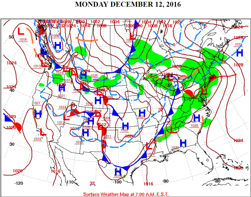 |
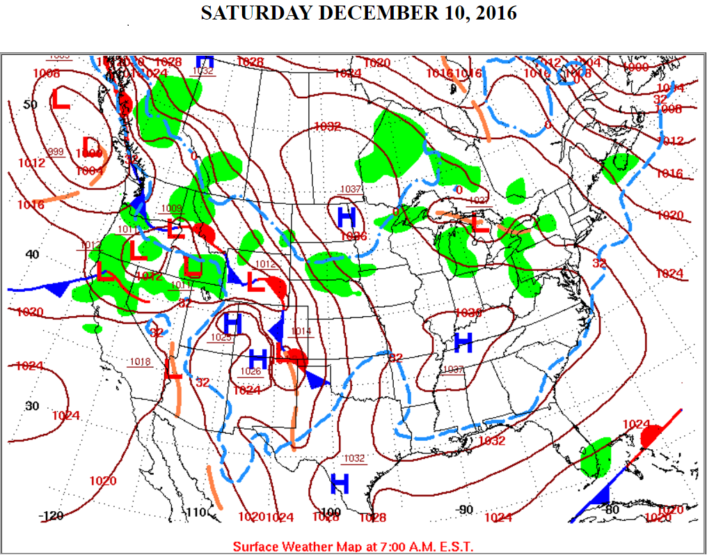
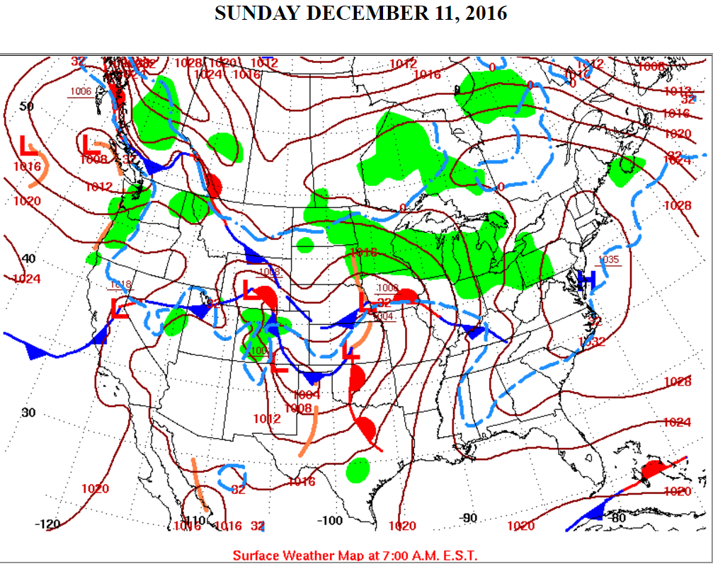
| Surface chart 7 AM Saturday | Surface chart 7 AM Sunday | Surface chart 7 AM Monday |
 |
Media use of NWS Web News Stories is encouraged! Please acknowledge the NWS as the source of any news information accessed from this site. |
|

