Overview - This information is still being updated
|
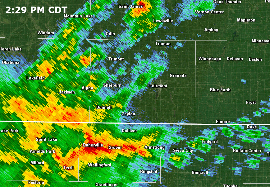
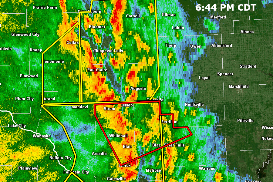
Thunderstorms moved northward from Iowa into southern Minnesota in the mid- afternoon on May 21st. One tornado touched down briefly near Fairmont in Martin County. Another potential tornado touched down near Mapleton in Blue Earth County. A brief tornado occurred just west of Red Wing as this line continued to the northeast. This thunderstorm complex develop and moved rapidly across southern Minnesota and into Western Wisconsin, where one more tornado touched down to the east of Eau Claire near Augusta and tracked about 10 miles to the north. |
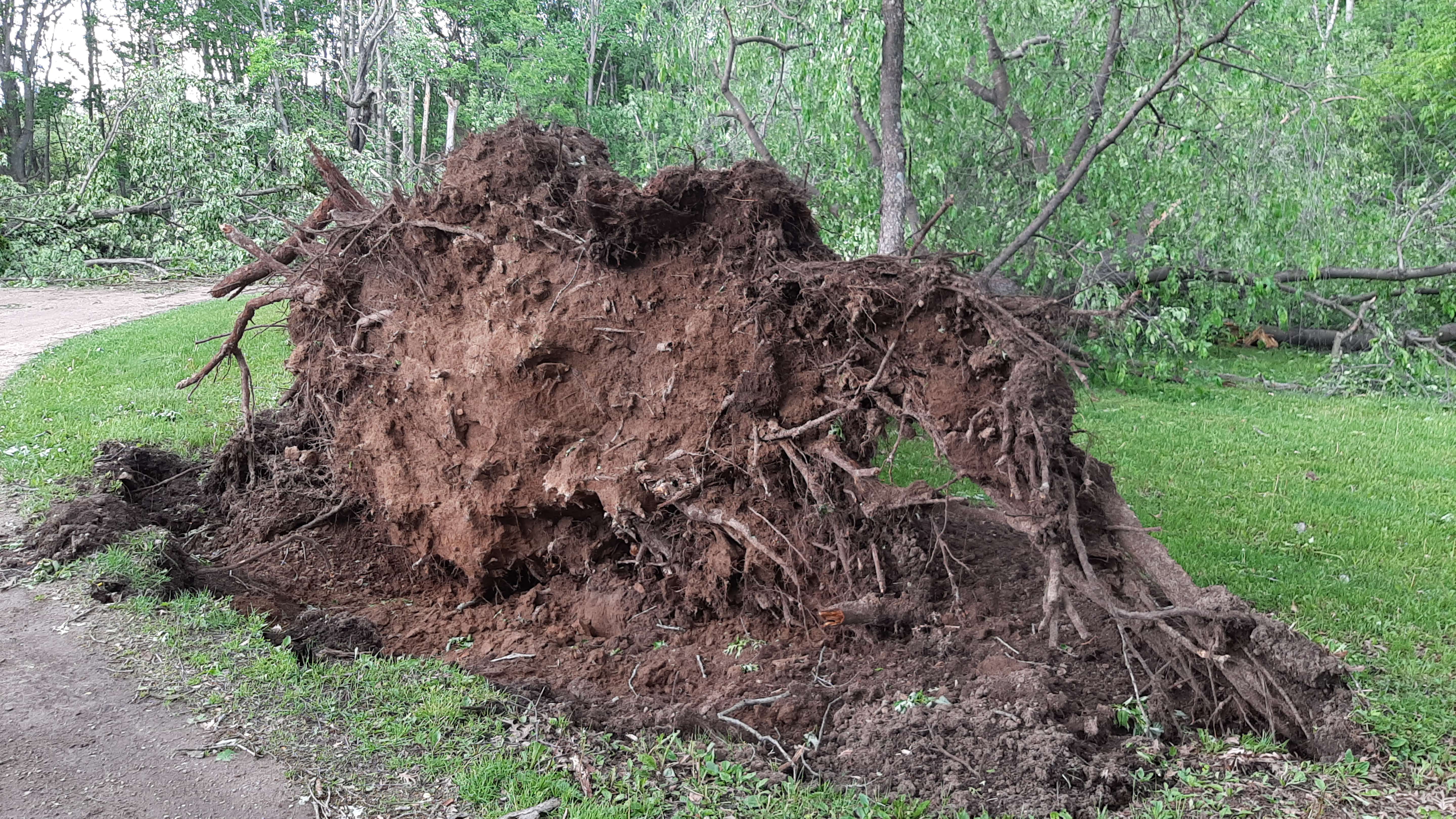 Uprooted tree near Augusta, WI |
Tornadoes:
|
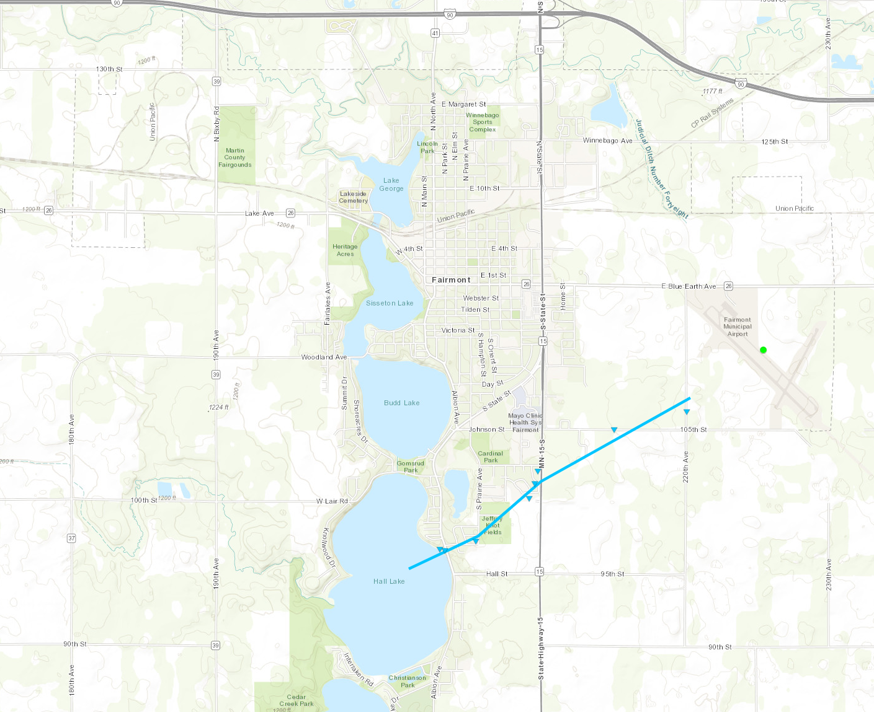
Tornado - Fairmont, MN
Track Map 
|
||||||||||||||||
|
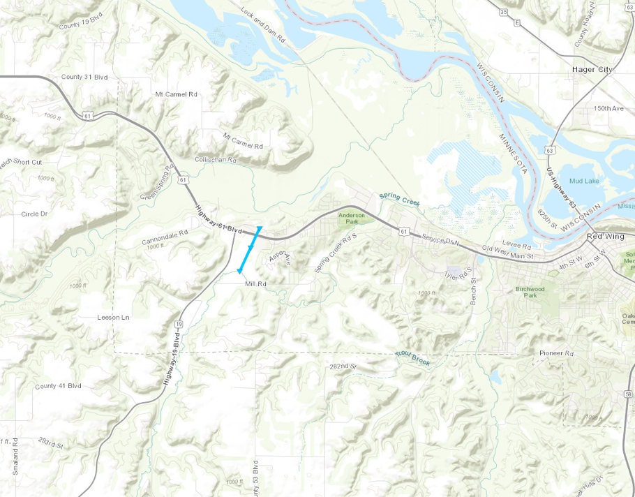
Tornado - Red Wing, MN
Track Map
Downloadable KMZ File |
||||||||||||||||
|
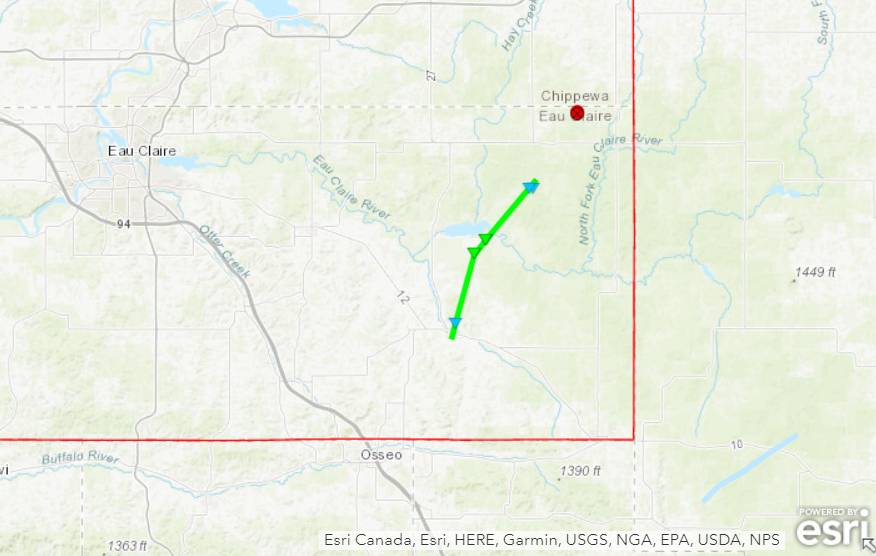
Tornado - Augusta, WI
|
||||||||||||||||
The Enhanced Fujita (EF) Scale classifies tornadoes into the following categories:
| EF0 Weak 65-85 mph |
EF1 Moderate 86-110 mph |
EF2 Significant 111-135 mph |
EF3 Severe 136-165 mph |
EF4 Extreme 166-200 mph |
EF5 Catastrophic 200+ mph |
 |
|||||
Radar
Header
 |
 |
| Radar loop showing storms moving into Martin County, MN | Radar loop as storms moved through eastern Eau Claire County, WI |
Storm Reports
NWUS53 KMPX 231558
LSRMPX

Preliminary Local Storm Report...Summary
National Weather Service Twin Cities/Chanhassen MN
1058 AM CDT Thu May 23 2024

..TIME...   ...EVENT...      ...CITY LOCATION...     ...LAT.LON...
..DATE...   ....MAG....      ..COUNTY LOCATION..ST.. ...SOURCE....
            ..REMARKS..

0300 PM     Tornado          1 SSW Fairmont          43.63N 94.47W
05/21/2024                   Martin             MN   Public

            LATE LSR - Social media photo received of
            potential tornado crossing Hall Lake, just
            south of Fairmont. Time estimated via radar.

0356 PM     Tstm Wnd Gst     3 ESE Fairmont          43.63N 94.42W
05/21/2024  M60 MPH          Martin             MN   AWOS

            AWOS station KFRM Fairmont AP.

0420 PM     Funnel Cloud     2 W Mapleton            43.93N 93.99W
05/21/2024                   Blue Earth         MN   Public

            Funnel Cloud photo shared via social media 2
            miles W of Mapleton. Will need to verify if
            tornado made contact with the ground.

0448 PM     Tstm Wnd Dmg     Albert Lea              43.65N 93.37W
05/21/2024                   Freeborn           MN   Emergency Mngr

            Correcting LSR time. Emergency Manager
            reported power lines and trees down in
            Albert Lea. Time estimated via radar.

0455 PM     Tstm Wnd Gst     2 N Albert Lea          43.68N 93.37W
05/21/2024  M47 MPH          Freeborn           MN   AWOS

            AWOS station KAEL Albert Lea AP.

0457 PM     Tstm Wnd Dmg     2 S Faribault           44.27N 93.27W
05/21/2024                   Rice               MN   Public

            Large tree down blocking roadway 2 miles
            south of Faribault. Time estimated via
            radar.

0500 PM     Tstm Wnd Dmg     Geneva                  43.82N 93.27W
05/21/2024                   Freeborn           MN   Emergency Mngr

            Emergency Manager reported trees and
            powerlines down in Geneva.

0500 PM     Tstm Wnd Dmg     Hollandale              43.76N 93.20W
05/21/2024                   Freeborn           MN   Emergency Mngr

            Emergency Manager reported trees and power
            poles snapped one quarter mile east of
            Hollandale.

0635 PM     Tstm Wnd Dmg     14 SW Eau Claire        44.65N 91.67W
05/21/2024                   Pepin              WI   Trained Spotter

            2 to 3 inch branches down along 150ft line
            of trees.

0645 PM     Tstm Wnd Dmg     1 WNW Chippewa Falls    44.94N 91.42W
05/21/2024                   Chippewa           WI   Amateur Radio

            Amateur radio reporting downed tree branches
            measuring 7 inches in diameter. Time
            estimated via radar.

0654 PM     Tstm Wnd Dmg     Albert Lea              43.65N 93.37W
05/21/2024                   Freeborn           MN   Emergency Mngr

            Emergency Manager reported power lines and
            trees down in Albert Lea.

0656 PM     Tornado          Augusta                 44.68N 91.12W
05/21/2024                   Eau Claire         WI   NWS Storm Survey

            PRELIMINARY INFORMATION: Storm survey
            results identified an EF1 tornado that
            touched down near Augusta, and moved north.
            The path length was about 10 miles, maximum
            width about 1/4 mile, and peak speeds near
            90 mph. Time estimated from radar.

0656 PM     Tstm Wnd Dmg     Augusta                 44.68N 91.12W
05/21/2024                   Eau Claire         WI   Emergency Mngr

            Emergency Management reported powerlines and
            trees down in Augusta. Time estimated via
            radar.

0656 PM     Tstm Wnd Gst     4 NNE Eau Claire        44.87N 91.47W
05/21/2024  M49 MPH          Chippewa           WI   ASOS

            ASOS station KEAU Eau Claire AP.

0708 PM     Tstm Wnd Dmg     9 S Boyd                44.83N 91.02W
05/21/2024                   Eau Claire         WI   Emergency Mngr

            EM reported that in the Town of Wilson there
            are multiple trees down in laying various
            directions. Time estimated by radar.

0708 PM     Tstm Wnd Dmg     6 SSE Cornell           45.08N 91.12W
05/21/2024                   Chippewa           WI   Trained Spotter

            Branches and trees down 6 miles SSE of
            Cornell. Time estimated via radar.

0710 PM     Tstm Wnd Dmg     4 SE Boyd               44.91N 90.98W
05/21/2024                   Chippewa           WI   Trained Spotter

            15-20 inch tree down, several 3-4 inch
            branches down. Time estimated via radar.

0716 PM     Tstm Wnd Dmg     4 SSE Stanley           44.90N 90.92W
05/21/2024                   Chippewa           WI   Trained Spotter

            Multiple trees uprooted & large limbs
            snapped. Time estimated from radar.


&&

$$

jrb
Rain Reports
NOUS43 KMPX 221518
PNSMPX
MNZ041>045-047>070-073>078-082>085-091>093-WIZ014>016-023>028-230318-

Public Information Statement
National Weather Service Twin Cities/Chanhassen MN
1018 AM CDT Wed May 22 2024

...48 HOUR PRECIPITATION REPORTS...

Location                     Amount    Time/Date       Provider
Farmington 0.7 N             4.00 in   0725 AM 05/22   COCORAHS
Balsam Lake 4SE              3.99 in   0700 AM 05/22   COCORAHS
Northfield                   3.84 in   0950 AM 05/22   CWOP
Arden Hills 0.8 SSW          3.60 in   0600 AM 05/22   COCORAHS
Woodbury 0.3 NNW             3.56 in   0545 AM 05/22   COCORAHS
Minneapolis Lower St. Anthon 3.51 in   0500 AM 05/22   COOP
New Brighton                 3.47 in   0945 AM 05/22   CWOP
Dawson 0.6 WNW               3.20 in   0800 AM 05/22   COCORAHS
Montevideo 8.5 WNW           3.19 in   0600 AM 05/22   COCORAHS
Maiden Rock 7.7 N            3.13 in   0700 AM 05/22   COCORAHS
Rosemount 2.7 W              3.07 in   0915 AM 05/22   COCORAHS
Golden Valley 1.0 NW         2.94 in   0700 AM 05/22   COCORAHS
Minneapolis 2.9 W            2.93 in   0628 AM 05/22   COCORAHS
Brooklyn Center 1.3 SE       2.91 in   0700 AM 05/22   COCORAHS
Little Falls 9.3 WNW         2.90 in   0700 AM 05/22   COCORAHS
Cannon Falls 7.9 ESE         2.89 in   0700 AM 05/22   COCORAHS
Clear Lake 5.9 NE            2.86 in   0700 AM 05/22   COCORAHS
Prior Lake 5.1 SSE           2.85 in   0750 AM 05/22   COCORAHS
Rosemount                    2.84 in   0800 AM 05/22   COOP
Chisago City 1.3 SSE         2.82 in   0700 AM 05/22   COCORAHS
Chanhassen 1.7 S             2.82 in   0600 AM 05/22   COCORAHS
St. Croix Falls              2.81 in   0700 AM 05/22   COOP
1.3 NW Princeton             2.81 in   0845 AM 05/22   HADS
River Falls 1SW              2.79 in   0700 AM 05/22   COCORAHS
Montgomery 2.1 N             2.79 in   0800 AM 05/22   COCORAHS
North Mankato 0.5 SE         2.71 in   0700 AM 05/22   COCORAHS
1.2 W Wanamingo              2.71 in   0700 AM 05/22   HADS
Minnetonka 2.0 SW            2.66 in   0700 AM 05/22   COCORAHS
Edina 1SW                    2.65 in   0700 AM 05/22   COCORAHS
1 WSW Richfield              2.64 in   0700 AM 05/22   COCORAHS
Zumbrota 1.6 NNW             2.64 in   0700 AM 05/22   COCORAHS
HASTINGS                     2.57 in   0950 AM 05/22   CWOP
Big Lake 2.4 N               2.56 in   0700 AM 05/22   COCORAHS
Weyerhaeuser 2.2 W           2.53 in   0734 AM 05/22   COCORAHS
Mankato 1ESE                 2.53 in   0700 AM 05/22   COCORAHS
Faribault 1.6 S              2.50 in   0700 AM 05/22   COCORAHS
Cottage Grove 1.7 NW         2.48 in   0600 AM 05/22   COCORAHS
Bay City 3.7 NNW             2.41 in   0700 AM 05/22   COCORAHS
Minneapolis-St. Paul AP      2.34 in   0853 AM 05/22   ASOS
Brooklyn Park 2E             2.27 in   0800 AM 05/22   COCORAHS
New Richmond AP              2.19 in   0935 AM 05/22   AWOS
South St. Paul AP            2.19 in   0935 AM 05/22   AWOS
St. Paul Dwtn AP             2.11 in   0853 AM 05/22   ASOS
Stillwater 7.4 NNE           2.09 in   0800 AM 05/22   COCORAHS
Menomonie 0.9 NW             2.07 in   0715 AM 05/22   COCORAHS

Observations are collected from a variety of sources with varying
equipment and exposures. We thank all volunteer weather observers
for their dedication. Not all data listed are considered official.

$$

Strus
 |
Media use of NWS Web News Stories is encouraged! Please acknowledge the NWS as the source of any news information accessed from this site. |
|