Overview
Heavy snow developed across South Dakota and northwest Iowa and advanced northeastward during the day February 24, 2018. Snowfall rates of 1 to 2 inches per hour were common. The snow tapered off from southwest to northeast during the evening, and ended in Wisconsin in the early morning hours of February 25th.
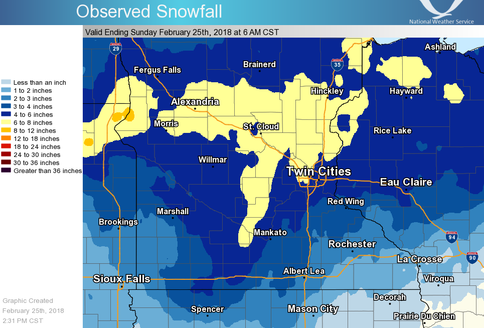
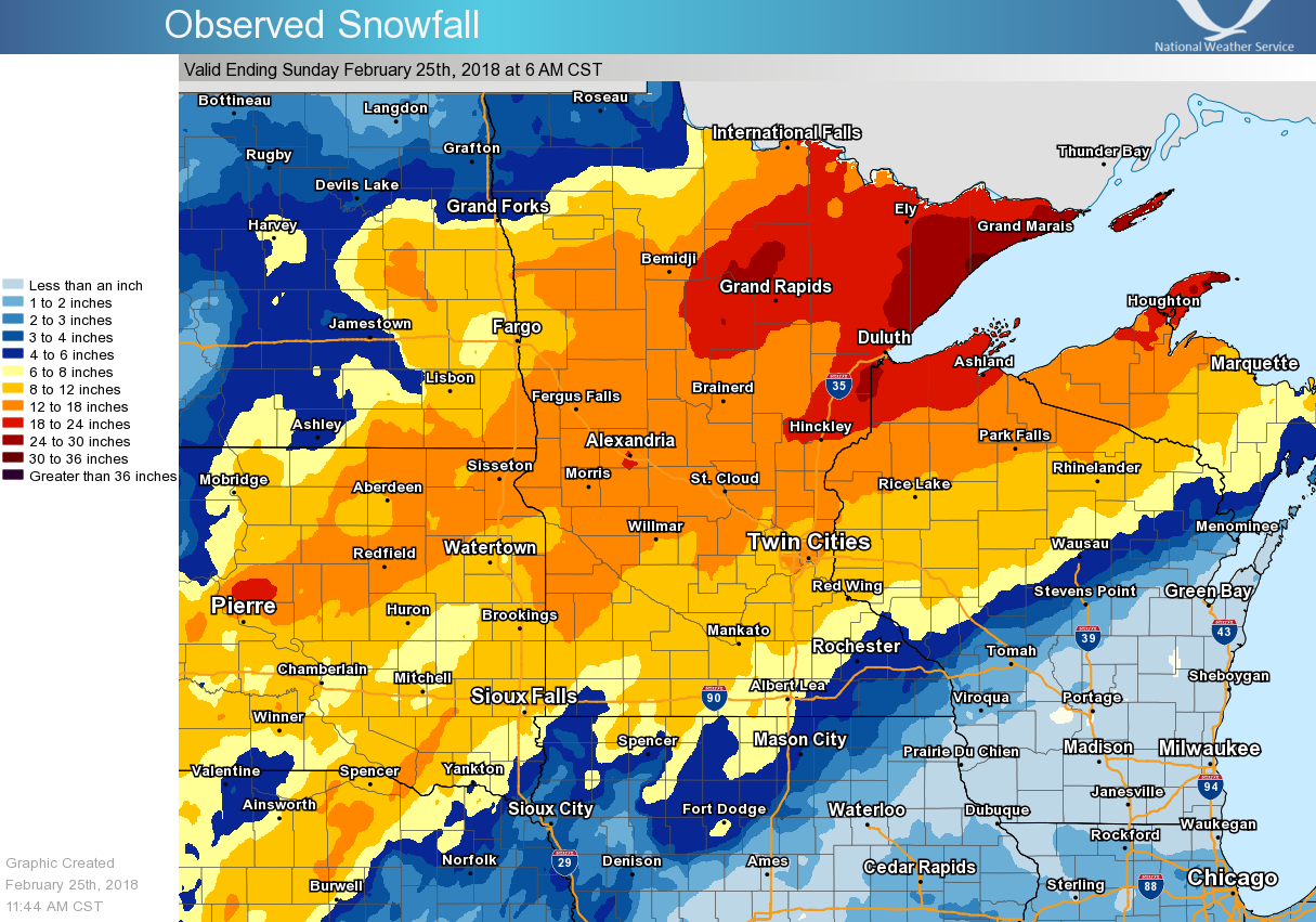
Snow accumulations of 5 to 9 inches were reported across central Minnesota. Lesser amounts in the 3 to 6 inch range were measured across southern Minnesota and western Wisconsin where snow mixed with freezing rain and sleet at times. The map below is smoothed and therefore does not show the several localized 8 or 9 inch totals reported.
Snowfall Reports
...Snowfall Reports from the February 24-25 Winter Storm... Location Amount Time/Date Provider ...Minnesota... ...Anoka County... 1 SE St. Francis 9.0 in 1021 AM 02/25 Public 4 W Oak Grove 8.0 in 1100 AM 02/25 Public Oak Grove 8.0 in 0840 AM 02/25 Public 3 WNW Stacy 7.0 in 0934 AM 02/25 Public Anoka 1SE 6.5 in 0700 AM 02/25 COCORAHS 1 W New Brighton 6.2 in 0800 AM 02/25 Cocorahs Blaine 2NNW 6.2 in 0600 AM 02/25 COCORAHS Lino Lakes 6.1 in 0905 AM 02/25 Public Andover 6.0 in 1021 AM 02/25 Public 1 SSE Coon Rapids 5.6 in 1053 AM 02/25 Public 2 SE Andover 5.5 in 0950 AM 02/25 Public ...Benton County... 5 SW Foley 6.5 in 0850 AM 02/25 Public Rice 5.5 in 0700 AM 02/25 COOP ...Blue Earth County... Mankato 5.0 in 0950 AM 02/25 Public Mankato 4E 4.0 in 0700 AM 02/25 UCOOP Pemberton 4.0 in 1010 AM 02/25 Public Mankato 4.0 in 1010 AM 02/25 Public ...Brown County... 1 NE New Ulm 7.0 in 1100 AM 02/25 Public Springfield 1NW 5.2 in 0700 AM 02/25 COCORAHS Sveadahl 5NNW 4.7 in 0650 AM 02/25 COCORAHS ...Carver County... New Germany 8.0 in 0940 AM 02/25 Public 1 SSW Norwood/Young America 8.0 in 1128 AM 02/25 Public Chanhassen NWS 5.5 in 0600 AM 02/25 Official NWS Obs Chaska 5.2 in 1039 AM 02/25 Broadcast Media Watertown 5.1 in 0430 AM 02/25 COCORAHS 2 SSW Victoria 5.0 in 0932 AM 02/25 COCORAHS Victoria 1WSW 5.0 in 0700 AM 02/25 COCORAHS Chaska 5.0 in 0625 AM 02/25 COCORAHS Carver 1W 4.8 in 0700 AM 02/25 COCORAHS Waconia 4.3 in 0600 AM 02/25 UCOOP ...Chippewa County... Montevideo 4.2 in 0700 AM 02/25 COCORAHS ...Chisago County... Rush City 3NE 6.8 in 0700 AM 02/25 COCORAHS Harris 5WNW 6.5 in 0800 AM 02/25 COCORAHS North Branch 1NNW 6.5 in 0600 AM 02/25 COCORAHS 7 ESE Harris 6.5 in 0645 AM 02/25 Public Stacy 1W 6.0 in 0700 AM 02/25 COCORAHS ...Dakota County... Burnsville 3ENE 5.5 in 0700 AM 02/25 COCORAHS 2 NE Lakeville 5.3 in 0110 AM 02/25 Trained Spotter Eagan 5.0 in 0945 AM 02/25 Public Eagan 1NW 4.8 in 0830 AM 02/25 COCORAHS Lakeville 4.5 in 1016 AM 02/25 Public Apple Valley 3ESE 4.5 in 0700 AM 02/25 COCORAHS 1 NNW Apple Valley 4.3 in 1024 AM 02/25 Public Inver Grove Hgts 1WSW 4.3 in 0715 AM 02/25 COCORAHS Hastings 4.0 in 1130 AM 02/25 Trained Spotter Hastings (L/D 2) 4.0 in 0600 AM 02/25 COOP Rosemount 3W 3.5 in 0919 AM 02/25 COCORAHS ...Douglas County... Alexandria 9.0 in 1000 AM 02/25 Public Carlos 3WSW 8.0 in 0530 AM 02/25 COOP Alexandria 7.5 in 0600 AM 02/25 COCORAHS 1 S Evansville 7.0 in 1127 AM 02/25 Public Farwell 5N 7.0 in 0745 AM 02/25 COCORAHS Brandon 1WNW 6.0 in 1000 AM 02/25 COCORAHS ...Faribault County... Winnebago 3.5 in 0630 AM 02/25 COOP Bricelyn 3.1 in 0700 AM 02/25 COOP Wells 3.0 in 0800 AM 02/25 COOP Blue Earth 3.0 in 0700 AM 02/25 COCORAHS Blue Earth 1S 2.9 in 0800 AM 02/25 COOP ...Goodhue County... Red Wing 4.0 in 0940 AM 02/25 Public Pine Island 4.0 in 1100 AM 02/25 Public Red Wing (L/D 3) 4.0 in 0600 AM 02/25 COOP Red Wing 4W 3.5 in 0700 AM 02/25 COCORAHS Vasa 5NNE 3.3 in 0700 AM 02/25 COCORAHS Nerstrand 4E 2.7 in 0700 AM 02/25 COCORAHS Goodhue 2.5 in 1100 AM 02/25 Public Zumbrota 2.3 in 0930 AM 02/25 Trained Spotter ...Hennepin County... Robbinsdale 2ESE 7.0 in 0700 AM 02/25 COCORAHS Maple Plain 7.0 in 0700 AM 02/25 Trained Spotter Excelsior 7.0 in 0945 AM 02/25 Public New Hope 6.9 in 1043 AM 02/25 Broadcast Media 2 SE Maple Grove 6.7 in 1017 AM 02/25 Public Maple Grove 6.6 in 1013 AM 02/25 Public Rogers 6.5 in 1100 AM 02/25 Public Edina 2 ENE 6.5 in 0830 AM 02/25 COCORAHS Robbinsdale 6.4 in 0700 AM 02/25 COCORAHS 2 E Plymouth 6.2 in 1002 AM 02/25 Public Brooklyn Center 1E 6.1 in 0700 AM 02/25 COCORAHS 1 SW Edina 6.0 in 1033 AM 02/25 Public Minneapolis St. Paul Airport 6.0 in 0600 AM 02/25 Official NWS Obs Minneapolis Downtown 6.0 in 0600 AM 02/25 COOP Plymouth 6.0 in 0930 AM 02/25 Public 3 SSW Minneapolis 6.0 in 0800 AM 02/25 Public Edina 1SW 6.0 in 1000 AM 02/25 COCORAHS 2 NE St. Bonifacius 6.0 in 1018 AM 02/25 Public Golden Valley 5.8 in 0700 AM 02/25 COCORAHS Plymouth 2ENE 5.8 in 0700 AM 02/25 COCORAHS 2 SW Minneapolis 5.8 in 0400 AM 02/25 NWS Employee Edina 1SE 5.7 in 0700 AM 02/25 COCORAHS 2 ENE Robbinsdale 5.7 in 0900 AM 02/25 Public Edina 5.7 in 0730 AM 02/25 Public 1 W Richfield 5.6 in 1028 AM 02/25 Public Long Lake 4SW 5.5 in 0700 AM 02/25 COCORAHS 3 ENE Chanhassen 5.5 in 0921 AM 02/25 Public Eden Prairie 3SE 5.4 in 0954 AM 02/25 COCORAHS Robbinsdale 5.3 in 1128 AM 02/25 Public 1 E Edina 5.0 in 0930 AM 02/25 Public Bloomington 1 ESE 4.5 in 0700 AM 02/25 COCORAHS ...Isanti County... Cambridge 3N 8.3 in 0700 AM 02/25 COCORAHS 2 S Cambridge 8.0 in 0930 AM 02/25 Public Cambridge 7.5 in 0940 AM 02/25 Trained Spotter 4 SW Spencer Brook 6.5 in 1100 AM 02/25 Public 3 SE Isanti 6.0 in 0945 AM 02/25 Public ...Kanabec County... Mora 7.0 in 0700 AM 02/25 COOP ...Kandiyohi County... Willmar 5N 4.5 in 0600 AM 02/25 COOP ...Lac qui Parle County... Montevideo 1SW 4.0 in 0700 AM 02/25 COOP Dawson 4.0 in 0700 AM 02/25 COOP ...Le Sueur County... New Prague 4.0 in 0700 AM 02/25 COCORAHS ...Martin County... Welcome 4.5 in 0800 AM 02/25 Trained Spotter Fairmont 4.5 in 0700 AM 02/25 COCORAHS ...McLeod County... Hutchinson 8.0 in 1007 AM 02/25 Public Glencoe 7.5 in 0800 AM 02/25 COCORAHS Hutchinson 7.2 in 0850 AM 02/25 Public Winsted 7.0 in 0950 AM 02/25 Public Lester Prairie 7.0 in 0945 AM 02/25 Public Hutchinson 5N 7.0 in 0700 AM 02/25 COCORAHS Winsted 7.0 in 0950 AM 02/25 Public Silver Lake 1NNW 5.7 in 0700 AM 02/25 COCORAHS ...Meeker County... Dassel 6.4 in 0700 AM 02/25 COCORAHS Litchfield 6.0 in 1019 AM 02/25 Public Watkins 3WSW 5.5 in 0900 AM 02/25 COCORAHS Cosmos 5.5 in 1116 AM 02/25 Public ...Mille Lacs County... Princeton 1NE 7.4 in 0700 AM 02/25 COCORAHS Milaca 7.0 in 0830 AM 02/25 COOP 2 NW Foreston 6.5 in 0915 AM 02/25 Trained Spotter ...Morrison County... 1 SW Little Falls 7.3 in 0630 AM 02/25 Cocorahs Little Falls 7.3 in 0700 AM 02/25 COCORAHS 3 SSW Camp Ripley 7.0 in 0945 AM 02/25 Public Camp Ripley 4E 6.1 in 0700 AM 02/25 COCORAHS ...Nicollet County... New Ulm 3SE 7.0 in 0539 AM 02/25 COOP St. Peter 6WSW 4.0 in 0700 AM 02/25 COCORAHS ...Pope County... Starbuck 6.0 in 1011 AM 02/25 Public Sedan 5.9 in 0920 AM 02/25 Public 1 SSE Glenwood 5.5 in 1029 AM 02/25 Public ...Ramsey County... 1 NNW Roseville 6.3 in 1040 AM 02/25 Broadcast Media North St. Paul 6.3 in 1005 AM 02/25 Public White Bear Lake 6.0 in 0930 AM 02/25 Public North St. Paul 1WNW 5.9 in 0700 AM 02/25 COCORAHS 1 NNW North St. Paul 5.8 in 0800 AM 02/25 Cocorahs 1 NNE White Bear Lake 5.8 in 0950 AM 02/25 Public North St. Paul 1NNW 5.8 in 0800 AM 02/25 COCORAHS Roseville 1NW 5.6 in 0700 AM 02/25 COCORAHS 3 SSW Maplewood 5.0 in 1011 AM 02/25 Public Roseville 2WNW 5.0 in 0600 AM 02/25 COCORAHS Little Canada 5.0 in 1024 AM 02/25 Public 1 NNW Vadnais Heights 4.7 in 1039 AM 02/25 Broadcast Media St. Paul 4.5 in 1039 AM 02/25 Broadcast Media ...Redwood County... Redwood Falls 5.0 in 1000 AM 02/25 Public Redwood Falls 4.7 in 0530 AM 02/25 COOP Lucan 4.5 in 0452 AM 02/25 COCORAHS ...Renville County... Olivia 6.0 in 1000 AM 02/25 Public Lake Lillian 5SE 5.0 in 0645 AM 02/25 COCORAHS Bird Island 7SSE 3.8 in 0700 AM 02/25 COCORAHS ...Rice County... Lonsdale 5.0 in 1008 AM 02/25 Public Montgomery 3ENE 5.0 in 0600 AM 02/25 COCORAHS Faribault 3.0 in 0940 AM 02/25 Public Veseli 1W 3.0 in 0500 AM 02/25 COCORAHS ...Scott County... Savage 6.5 in 1016 AM 02/25 Public 1 W New Prague 5.0 in 0545 AM 02/25 Trained Spotter Jordan 1SW 4.9 in 0530 AM 02/25 COOP 4 WNW Savage 4.6 in 0825 AM 02/25 Dept of Highways Belle Plaine 4.0 in 1100 AM 02/25 Public ...Sherburne County... 3 S Princeton 9.0 in 1003 AM 02/25 Public 3 E Orrock 9.0 in 0930 AM 02/25 Public 1 N Elk River 8.0 in 1020 AM 02/25 Public 3 N Becker 8.0 in 0740 AM 02/25 Public Becker 2NNW 7.4 in 0700 AM 02/25 COCORAHS Big Lake 7.0 in 1020 AM 02/25 Public Princeton 2WSW 6.8 in 1200 AM 02/25 COCORAHS 3 NNW Monticello 6.5 in 1023 AM 02/25 Public Orrock 2SE 6.4 in 0700 AM 02/25 COCORAHS Elk River 6.2 in 0700 AM 02/25 COCORAHS St. Cloud Airport 6.0 in 0600 AM 02/25 Official NWS Obs ...Sibley County... Gaylord 8.0 in 0900 AM 02/25 Amateur Radio ...Stearns County... St. Cloud (SCSU) 7.5 in 0700 AM 02/25 UCOOP Kimball 3N 7.3 in 0600 AM 02/25 COOP Cold Spring 6.1 in 0700 AM 02/25 COCORAHS Paynesville 1SSW 6.0 in 0700 AM 02/25 COCORAHS Melrose 6.0 in 0700 AM 02/25 COOP Sartell 1SSE 5.8 in 0700 AM 02/25 COCORAHS Cold Spring 5.5 in 1023 AM 02/25 Public St. Joseph 5.0 in 0700 AM 02/25 COCORAHS ...Steele County... Ellendale 3.5 in 0700 AM 02/25 COCORAHS Owatonna 3.2 in 0700 AM 02/25 COCORAHS ...Stevens County... Donnelly 2WNW 6.3 in 0630 AM 02/25 COCORAHS Donnelly 6.3 in 0929 AM 02/25 Public ...Todd County... Long Prairie 7.0 in 1100 AM 02/25 Public Long Prairie 6.6 in 0600 AM 02/25 COOP ...Waseca County... Waseca 1NNE 3.1 in 0700 AM 02/25 COCORAHS ...Washington County... Forest Lake 7.0 in 0940 AM 02/25 Public Oakdale 5.5 in 0945 AM 02/25 Public Woodbury 5.3 in 0700 AM 02/25 COCORAHS 1 SSE Oakdale 5.0 in 1120 AM 02/25 Public Stillwater 1NE 4.8 in 0809 AM 02/25 COCORAHS Afton 1E 4.5 in 0900 AM 02/25 COCORAHS 1 NNW Cottage Grove 4.0 in 1038 AM 02/25 Broadcast Media ...Wright County... Cokato 7.0 in 0940 AM 02/25 Public Buffalo 7.0 in 1110 AM 02/25 Public St. Michael 1E 7.0 in 0800 AM 02/25 COCORAHS 1 WNW Rockford 6.2 in 0630 AM 02/25 Public 2 NE Montrose 6.2 in 0800 AM 02/25 Trained Spotter St. Michael 2ENE 5.6 in 0630 AM 02/25 COCORAHS St. Michael 5.0 in 1030 AM 02/25 Public Monticello 4WNW 5.0 in 0800 AM 02/25 COCORAHS ...Wisconsin... ...Barron County... Haugen 6.0 in 1100 AM 02/25 Public 7 NNE Cumberland 5.0 in 0930 AM 02/25 Public Cumberland 4.7 in 0800 AM 02/25 Trained Spotter Chetek 2SE 4.0 in 0700 AM 02/25 COCORAHS ...Chippewa County... Bloomer 5.2 in 0800 AM 02/25 COOP Cornell 4W 5.0 in 0800 AM 02/25 COCORAHS Cornell 4.5 in 1008 AM 02/25 Public 4 NNE Cornell 4.0 in 1117 AM 02/25 Public Jim Falls 3NW 3.7 in 0630 AM 02/25 COOP ...Dunn County... Boyceville 3NNE 6.0 in 0700 AM 02/25 COCORAHS Elk Mound 1ENE 4.5 in 0700 AM 02/25 COCORAHS Menomonie 3.8 in 0810 AM 02/25 Trained Spotter ...Eau Claire County... Eau Claire 1WNW 4.7 in 0500 AM 02/25 COCORAHS Eau Claire 3.9 in 0600 AM 02/25 Official NWS Obs ...Pepin County... Stockholm 2NE 2.8 in 0800 AM 02/25 COCORAHS ...Pierce County... Ellsworth 1S 5.0 in 0700 AM 02/25 COCORAHS River Falls 1SW 4.0 in 0700 AM 02/25 COCORAHS River Falls 1S 4.0 in 0700 AM 02/25 COCORAHS Ellsworth 1E 3.5 in 0700 AM 02/25 COOP ...Polk County... 5 SSE Osceola 6.5 in 1004 AM 02/25 Trained Spotter Nye 2E 4.5 in 0800 AM 02/25 COCORAHS ...Rusk County... 12 NNE Bruce 7.0 in 1100 AM 02/25 Public Ladysmith 2WNW 4.8 in 0700 AM 02/25 COCORAHS Bruce 1E 3.0 in 0700 AM 02/25 COCORAHS ...St. Croix County... Roberts 4.5 in 0715 AM 02/25 COOP Lake St. Croix Beach 4E 4.1 in 0700 AM 02/25 COCORAHS Baldwin 4.0 in 0945 AM 02/25 Public Baldwin 4.0 in 0700 AM 02/25 COOP Deer Park 2SE 3.5 in 0700 AM 02/25 COCORAHS Observations are collected from a variety of sources with varying equipment and exposures. We thank all volunteer weather observers for their dedication. Not all data listed are considered official.
Radar
Radar evolution of the snow shield from 9:00 AM CST February 24, 2018 through 3:00 AM CST February 25, 2018.
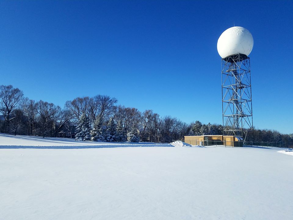
Photos
 |
 |
 |
 |
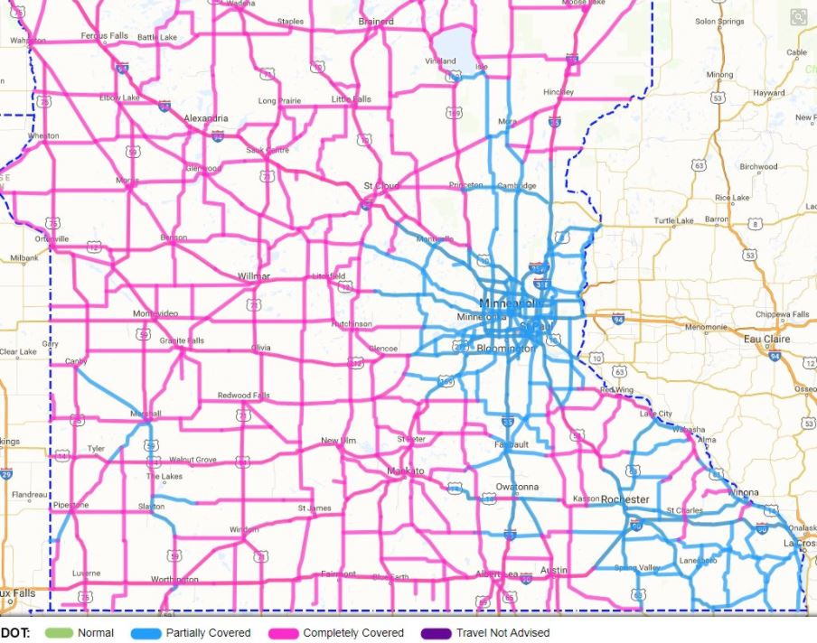 |
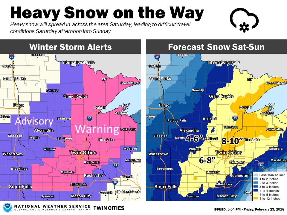
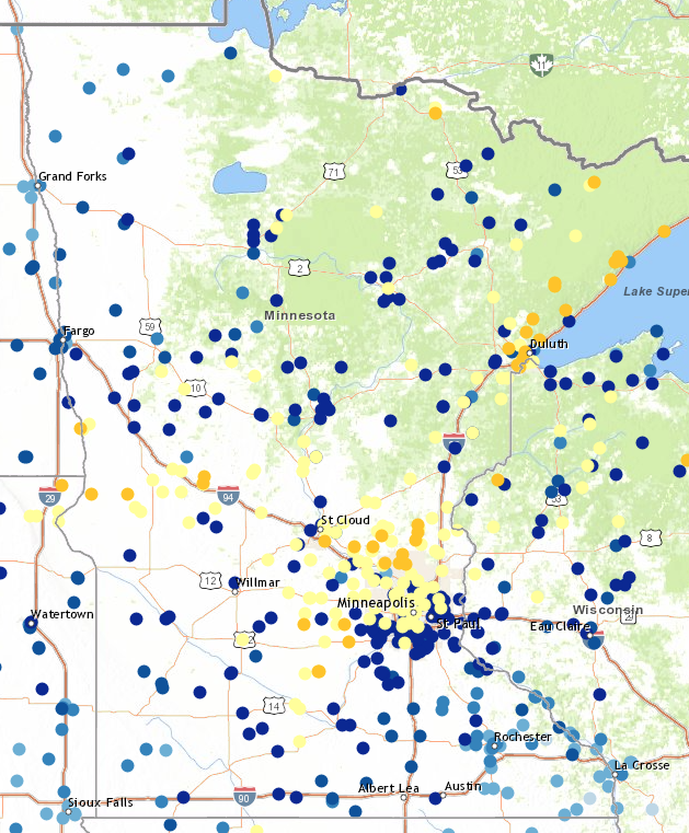
| The forecast from Friday afternoon, February 23, 2018. | Reports across the region. The yellow dots are 6+ inches; blue dots are less than 6 inches. | 7 day total snowfall ending February 25, 2018 | The beautiful morning after with snow on top of the radar tower | MN DOT Road Conditions at 6:30am CST 2/25/2018. |
 |
Media use of NWS Web News Stories is encouraged! Please acknowledge the NWS as the source of any news information accessed from this site. |
|

