Overview
|
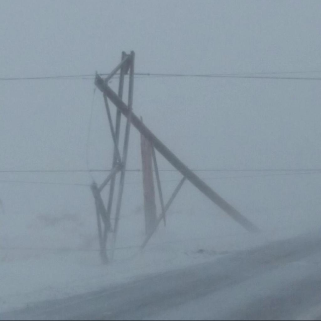
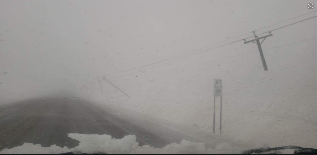
On Wednesday, April 10, a band of heavy snow developed in advance of a low pressure system over the Plains and lifted north across the region slowly during the day. It produced 1 to 2 inches of snow an hour at times and was even accompanied by lightning and thunder across southern Minnesota. Another band developed over Iowa during the evening and lifted north overnight, producing another round of thundersnow and hourly snow rates of 1 to 2 inches early Thursday morning. Most of the snow occurred with these two rounds. Snowfall totals of 6 to 12 inches were common. Warmer air aloft begin to arrive Thursday morning across southern Minnesota, causing the snow to turn to a wintry mix of sleet, snow, and rain. Even as surface temperatures remained below freezing, a few severe thunderstorms developed Thursday morning over Steele, Renville, Redwood, Chippewa, and Yellow Medicine counties as the warm air aloft produced elevated instability. Quarter size hail was reported with all three storms. The worst of the wind occurred Thursday. East winds gusting between 50 and 65 mph resulted in 650+ damaged power poles and hundreds of lines down. The Associated Press reported 100,000 people in Minnesota, South Dakota, Iowa, and Wisconsin had lost power. The wind also produced widespread blizzard conditions across western Minnesota, where most of the precipitation remained snow throughout the event. By Thursday night, winds began to subside and the precipitation was more patchy. A final round of snow occurred Friday morning on the backside of the low, with another inch or two falling. This storm pushed Eau Claire's seasonal snowfall into record territory at 98.8 inches. The previous record was 89.3 inches from the 1996-97 season.
|
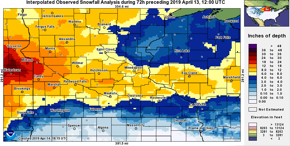 Map of observed snowfall from April 10-12. The yellow shading shows amounts over 6 inches, and the orange shading shows amounts in excess of a foot. The snow was difficult to measure due the very strong winds that accompanied this storm and the change over to various precipitation types. |
Travel Impacts
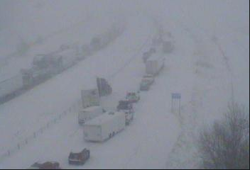
This winter storm brought significant travel impacts across Minnesota and Wisconsin. Several state roads across southwestern MN were closed, as was I-35 across a portion of southern Minnesota due to numerous accidents along that stretch.
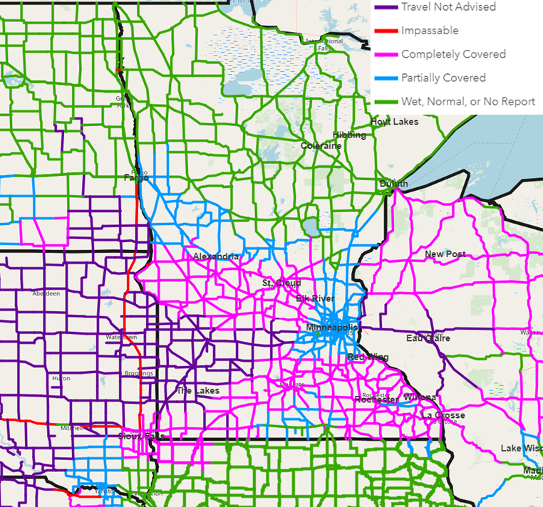 |
| Road conditions across Minnesota and western Wisconsin at noon on April 12. MNDOT and WisDOT were advising no travel in the purple areas of southwestern Minnesota and west central Wisconsin. |
Photos
 |
 |
 |
 |
 |
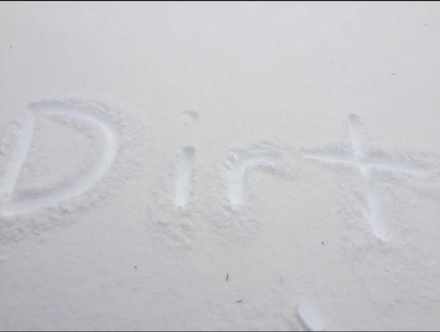
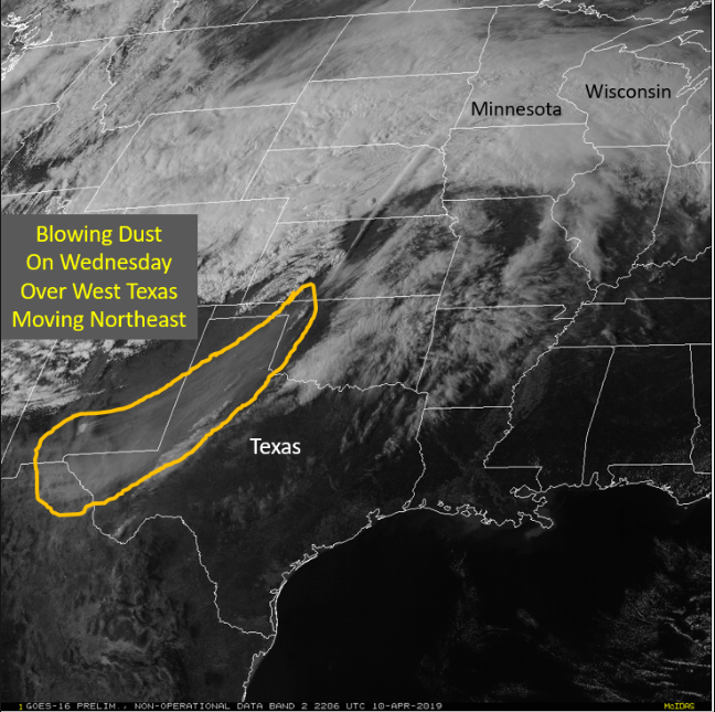
| The snow had a reddish brown tint to it thanks to dust from the south. Photo courtesy of Tim Lundahl. | Satellite captured the blowing dust over west Texas and southeastern New Mexico. The dust was lofted to the jet stream level and transported northward, mixing with the falling snow. | The initial band of heavy snow produced numerous accidents along I-35 from Medford to Faribault, resulting in a closure of the interstate for a time. Photo courtesy of MnDOT. | . Strong winds resulted in 650+ power poles damaged and hundreds of lines down. Photo courtesy of Xcel Energy. | Another power pole snapped due to the strong wind. Photo courtesy of Cory Green. |
Meteorology and Radar
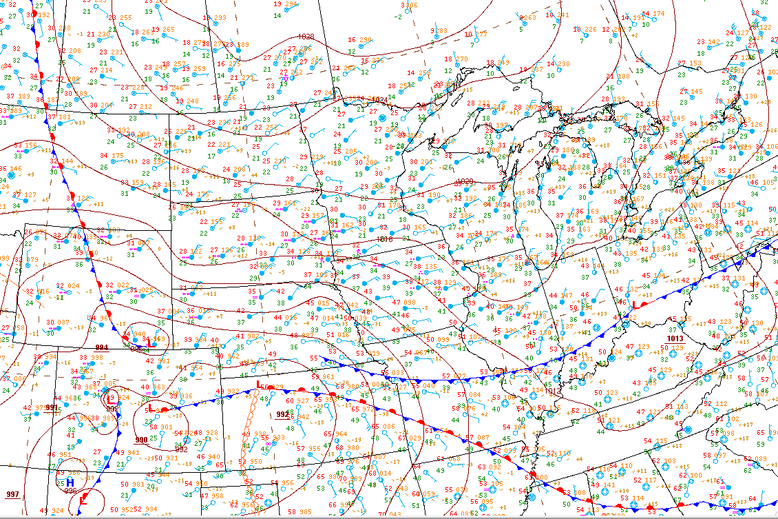
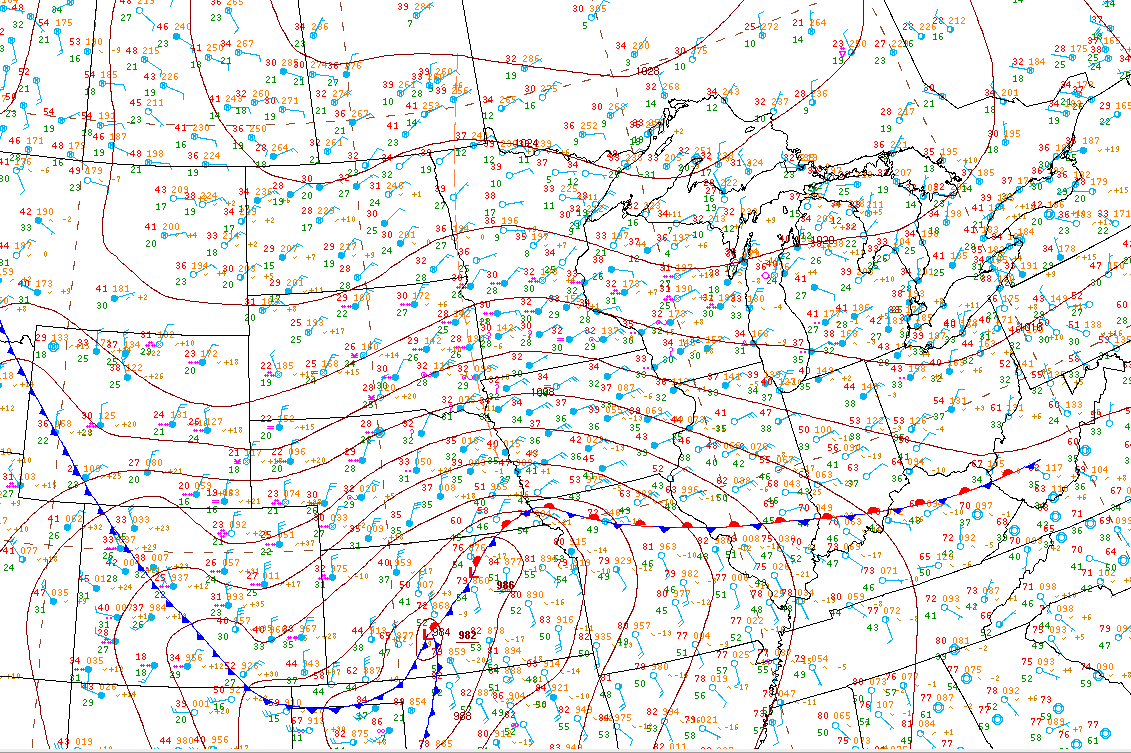
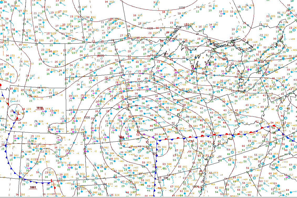
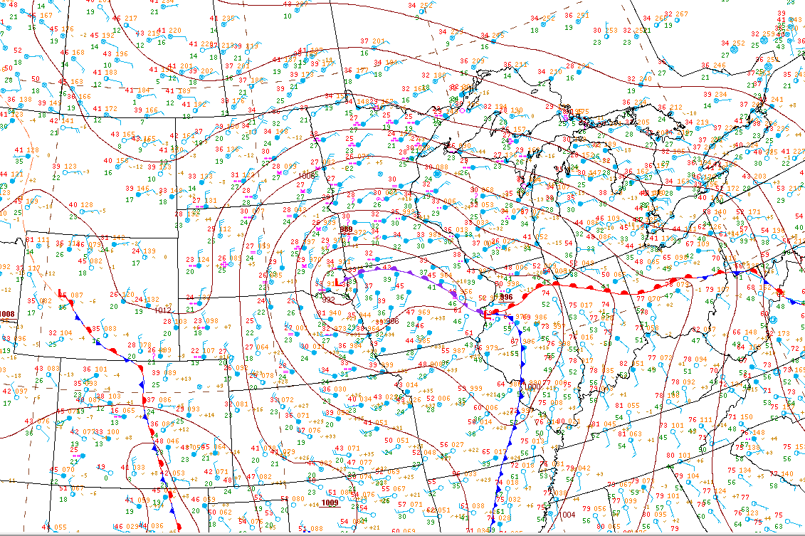
A strong low pressure system developed over Colorado and tracked east across Kansas, then northward along the Nebraska/Iowa border and northeast across the Upper Midwest. The maps below are the official Weather Prediction Center's surface analysis.
 |
 |
 |
 |
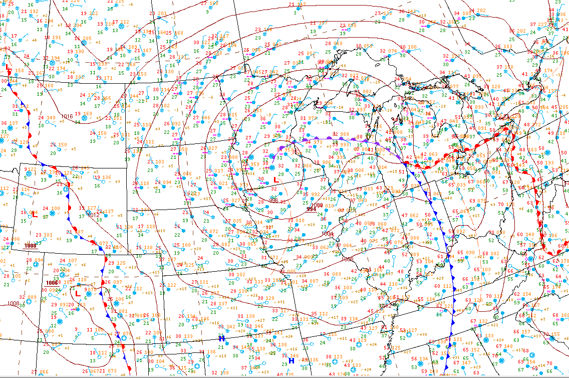 |
| 7 AM Wednesday | 7 PM Wednesday | 7 AM Thursday | 7 PM Thursday | 7 AM Friday |
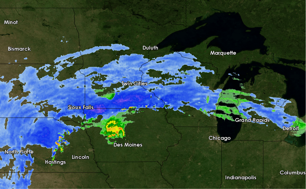
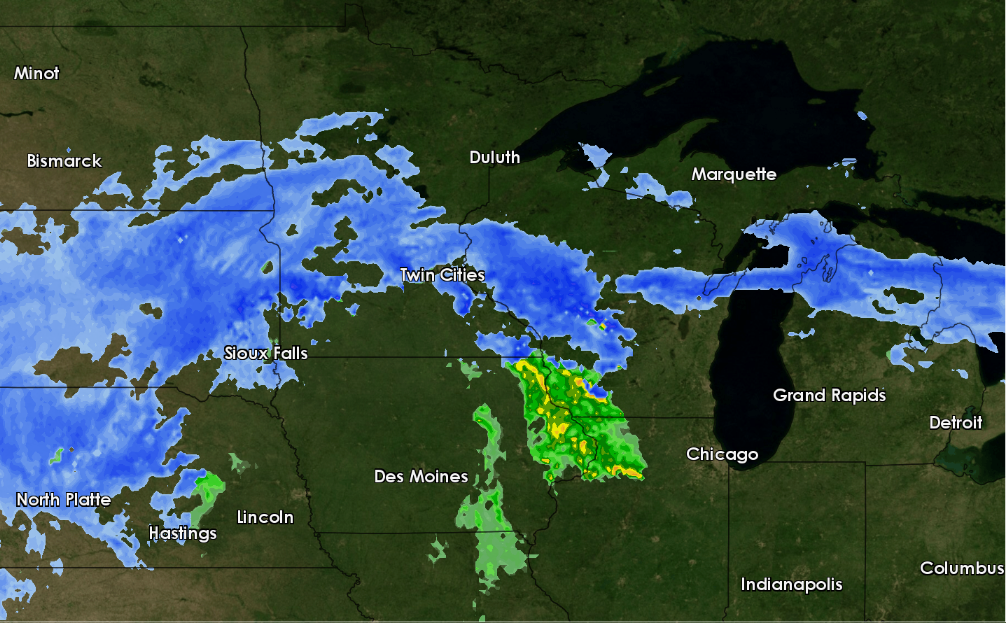
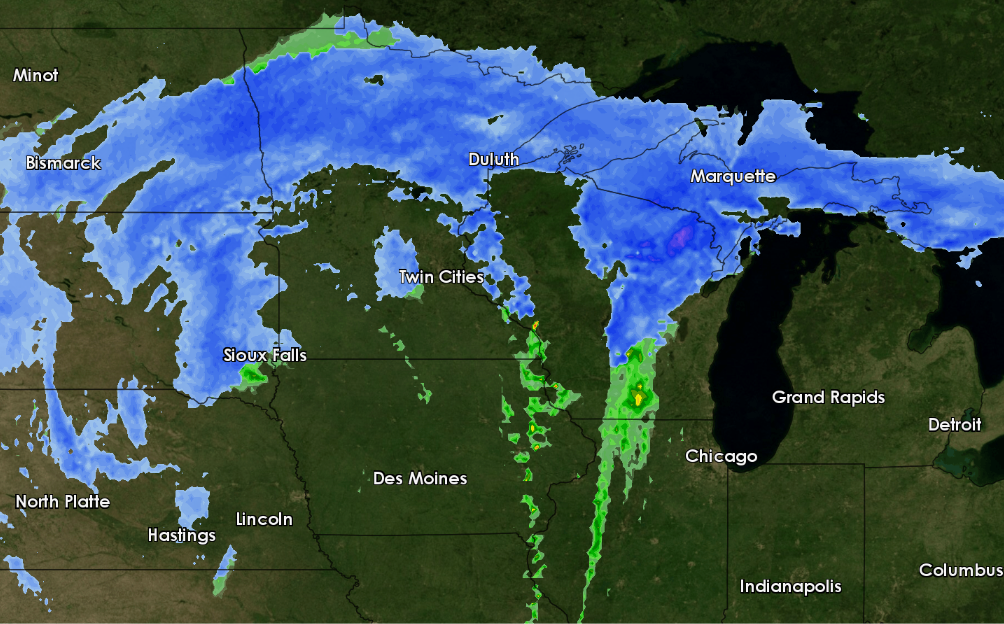
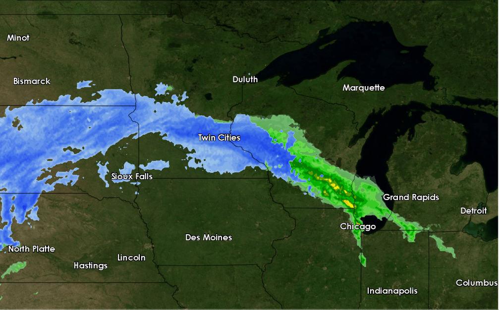 |
 |
 |
 |
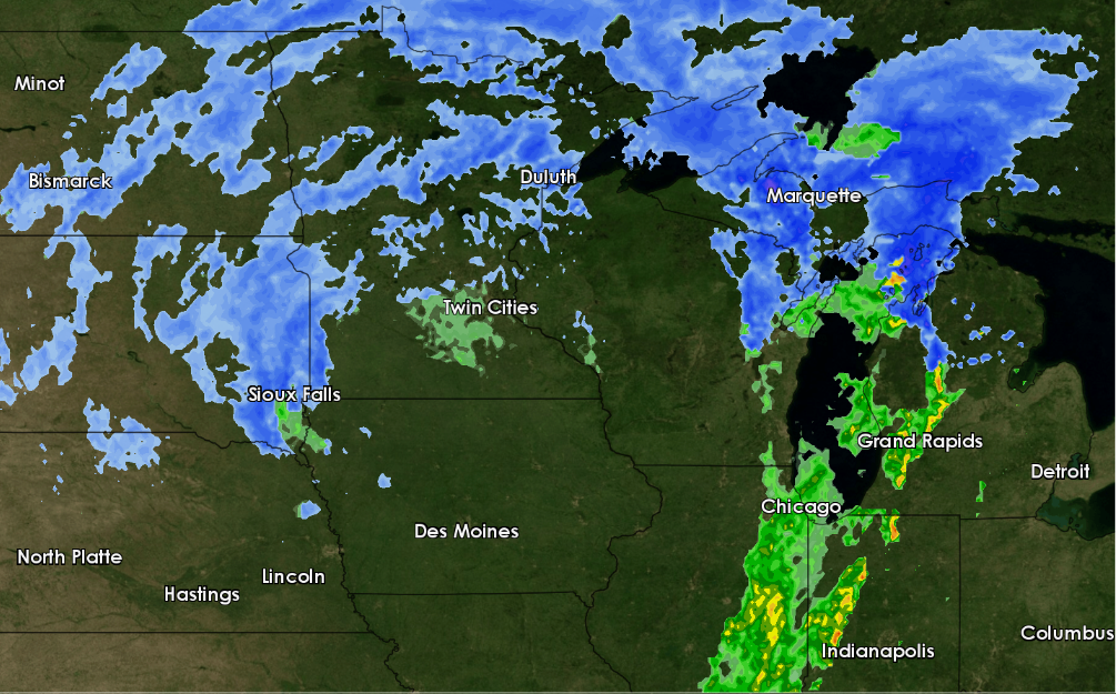 |
| Winter radar reflectivity showing the first band of heavy snow lifting north slowly. Blue is snow/sleet and green is rain. (4 PM on 4/10) | Radar reflectivity showing another heavy band of snow developing overnight. (1 AM on 4/11) | Radar reflectivity showing the snow continuing during the morning of 4/11. A couple Severe Thunderstorm Warnings were issued for thunderstorms embedded in the snow across western MN producing large hail. (840 AM on 4/11) | Radar reflectivity showing the main band of snow shifting well north, but rain, snow, and sleet showers continue in waves across southern MN into WI. (5 PM on 4/11) | Radar reflectivity showing continues rain and snow showers overnight. (1 AM on 4/12) |
 |
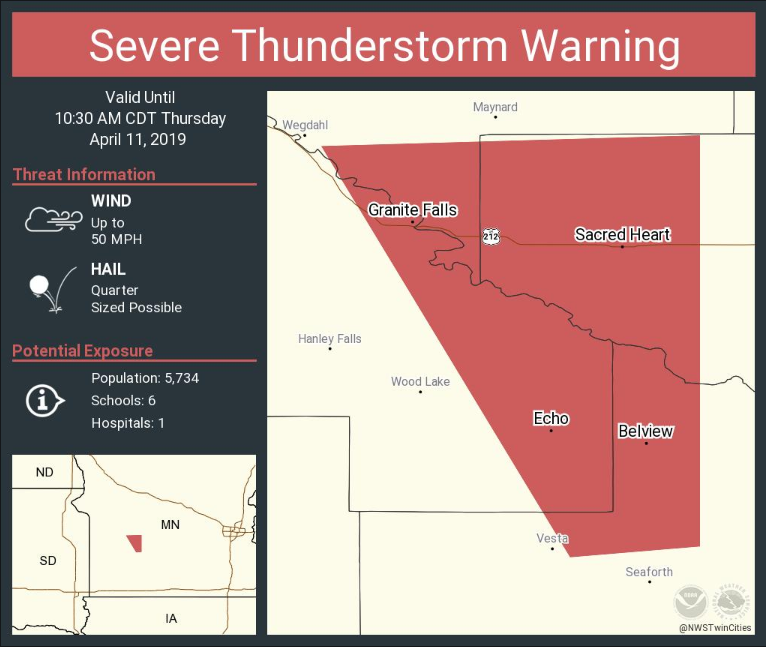 |
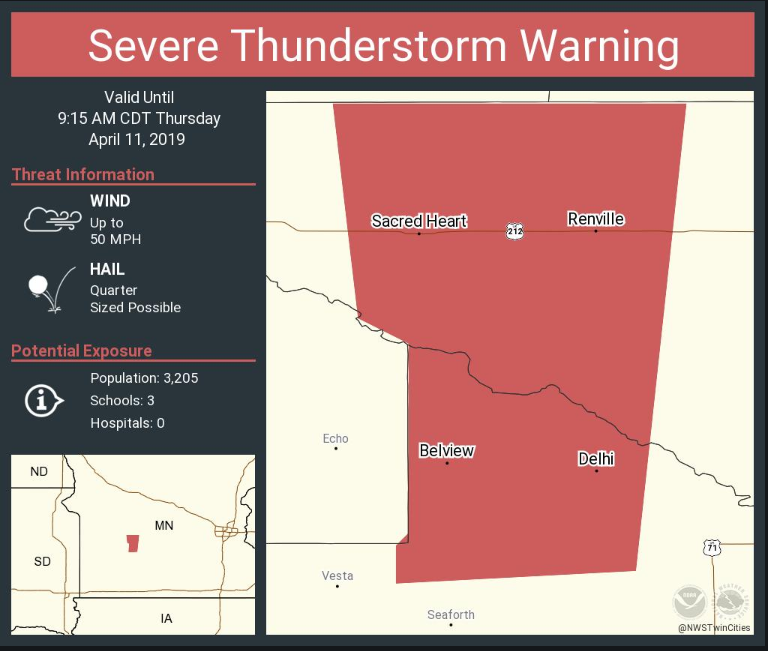
| The first Severe Thunderstorm Warning of the year was issued for a thunderstorm producing quarter size hail and blinding snow. | A second Severe Thunderstorm Warning was issued about an hour later for another thunderstorm producing quarter size hail and blinding snow. |
 |
 |
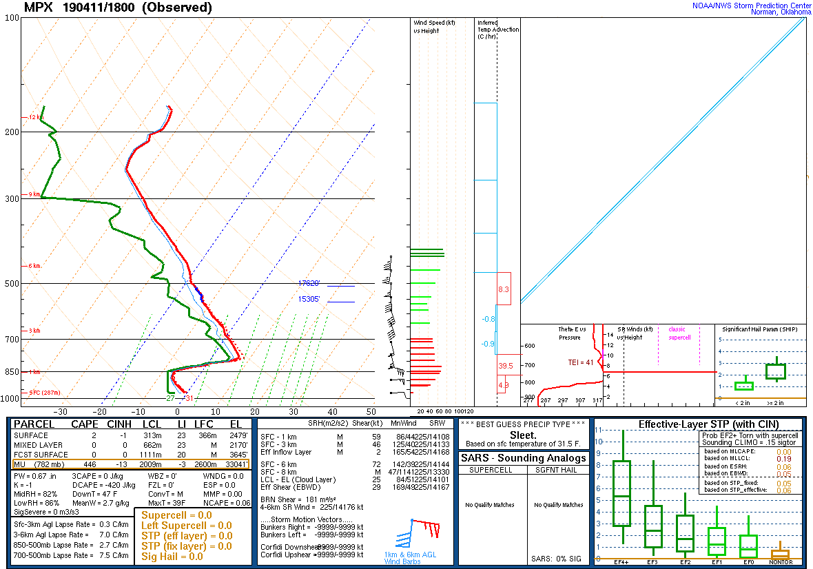 |
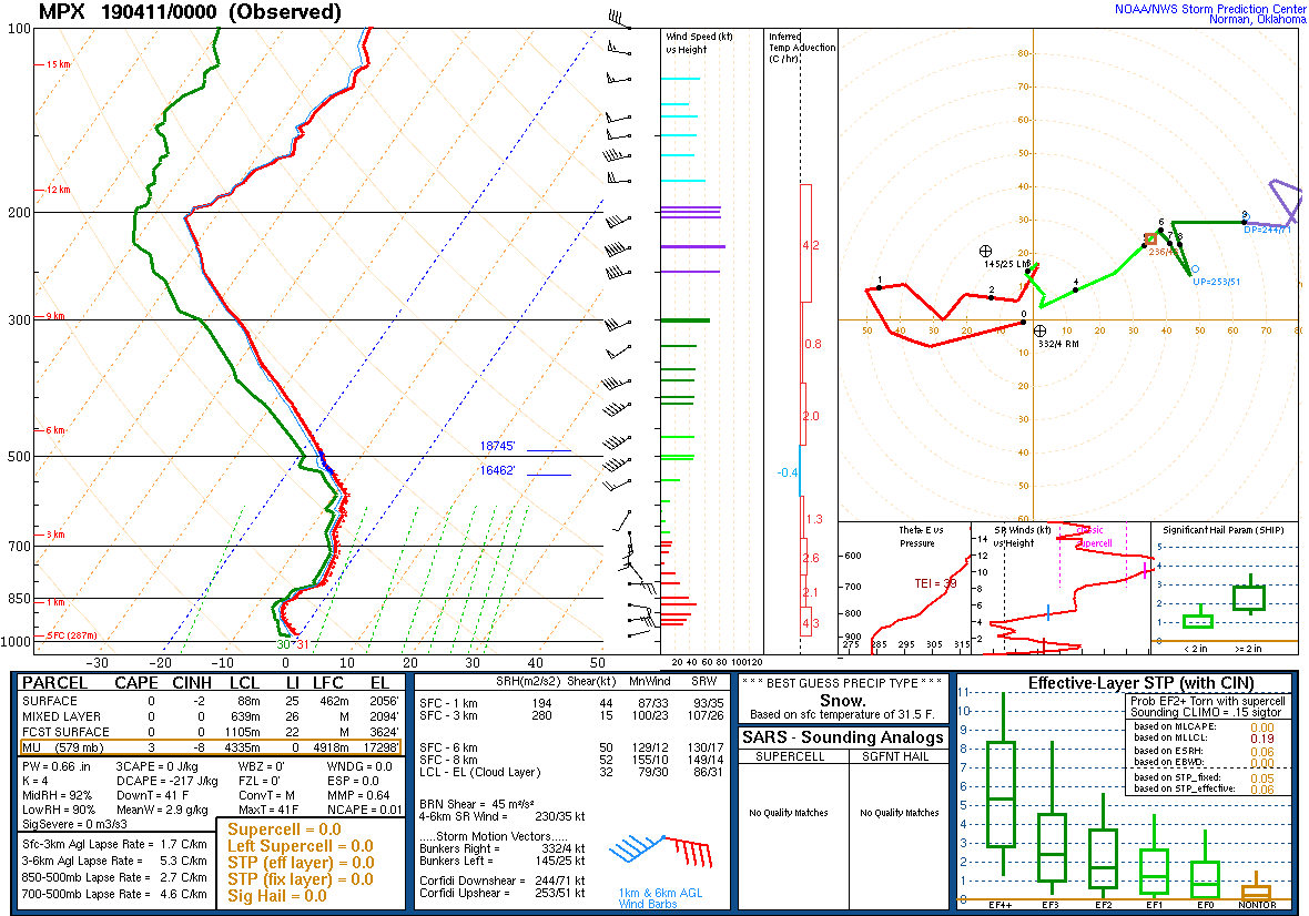
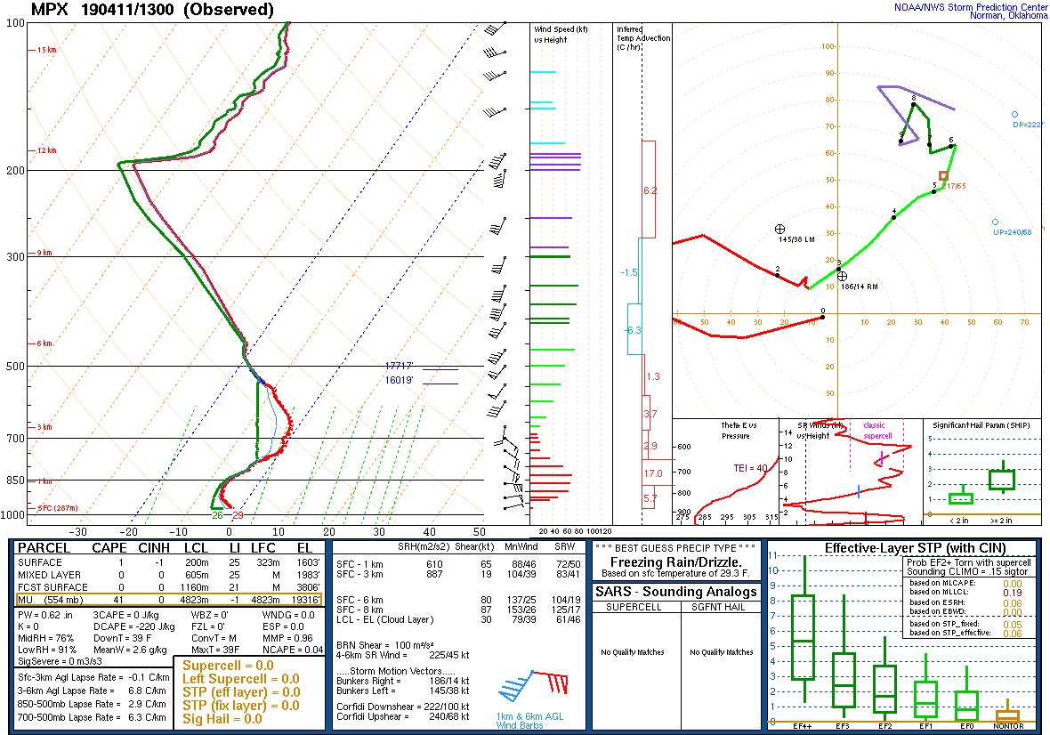
| The sounding from 7 PM Wednesday shows a pure snow atmosphere. | The sounding from early Thursday morning shows a warm layer developing around 700 mb, but the atmosphere is still cold enough for all snow. | A special sounding taken midday Thursday shows the arrival of a very pronounced warm layer between 850-700 mb (+7C). This allowed the snow to completely melt in this layer and then refreeze into sleet in the very cold air beneath that layer before reaching the ground. |
Peak Wind Reports
...HIGHEST WIND REPORTS FROM APRIL 11TH...

Location                     Speed     Time/Date       Provider

...Minnesota...

...Anoka County...
Blaine AP                    41 MPH    0145 PM 04/11   AWOS
Wyoming 6WSW                 36 MPH    0606 PM 04/11   RAWS
Lino Lakes                   36 MPH    0153 PM 04/11   CWOP

...Benton County...
Foley 6WSW                   43 MPH    0410 PM 04/11   MNDOT
Rice 1NNW                    41 MPH    1211 PM 04/11   MNDOT
Sauk Rapids                  38 MPH    0824 AM 04/11   CWOP

...Blue Earth County...
Mankato AP                   52 MPH    0800 AM 04/11   AWOS
Mankato US-169 Mile Post 52  40 MPH    0715 AM 04/11   MNDOT

...Brown County...
Springfield                  36 MPH    1031 AM 04/11   CWOP
New Ulm AP                   33 MPH    1116 AM 04/11   AWOS

...Carver County...
Victoria                     51 MPH    0948 AM 04/11   CWOP
Carver 3S                    51 MPH    0949 AM 04/11   RAWS
Mayer 1NE                    50 MPH    1016 AM 04/11   MNDOT
New Germany 1NW              48 MPH    1205 PM 04/11   MNDOT

...Chippewa County...
Montevideo AP                46 MPH    0435 AM 04/11   AWOS

...Chisago County...
Almelund                     40 MPH    0132 PM 04/11   CWOP
Harris 2N                    38 MPH    0210 PM 04/11   MNDOT
Rush City AP                 37 MPH    1215 PM 04/11   ASOS
Scandia                      32 MPH    0150 PM 04/11   CWOP

...Dakota County...
Lakeville AP                 41 MPH    1035 AM 04/11   AWOS
South St. Paul 1WSW          40 MPH    0845 AM 04/11   MNDOT
South St. Paul AP            38 MPH    0855 AM 04/11   AWOS

...Douglas County...
Alexandria AP                54 MPH    0251 PM 04/11   ASOS
Alexandria 2SSE              45 MPH    0331 PM 04/11   MNDOT

...Faribault County...
Easton                       51 MPH    0233 PM 04/11   CWOP
Minnesota Lake               45 MPH    0245 PM 04/11   CWOP

...Freeborn County...
Albert Lea AP                31 MPH    0511 PM 04/11   AWOS

...Goodhue County...
Cannon Falls 7SSE            55 MPH    0450 PM 04/11   MNDOT
Red Wing 4W                  52 MPH    0430 AM 04/11   MNDOT
Stanton AP                   51 MPH    0435 PM 04/11   AWOS
Red Wing                     37 MPH    1101 AM 04/11   CWOP
Zumbrota                     35 MPH    1143 AM 04/11   CWOP

...Hennepin County...
Eden Prairie AP              54 MPH    0813 AM 04/11   ASOS
Crystal AP                   53 MPH    0136 PM 04/11   ASOS
Minneapolis-St. Paul AP      51 MPH    0111 PM 04/11   ASOS
Edina                        50 MPH    0446 AM 04/11   CWOP
Bloomington                  45 MPH    0801 AM 04/11   CWOP
Mound                        43 MPH    0900 AM 04/11   CWOP
Robbinsdale                  41 MPH    1257 PM 04/11   CWOP
Golden Valley                40 MPH    1000 AM 04/11   CWOP
Richfield 3ESE               37 MPH    0850 AM 04/11   MNDOT
Maple Grove                  35 MPH    1015 AM 04/11   MNDOT

...Isanti County...
Cambridge AP                 33 MPH    0155 PM 04/11   AWOS
Cambridge                    31 MPH    0145 PM 04/11   CWOP

...Kanabec County...
Mora 1ENE                    42 MPH    0308 PM 04/11   RAWS
Mora AP                      33 MPH    0136 PM 04/11   AWOS

...Kandiyohi County...
Willmar                      51 MPH    1030 AM 04/11   CWOP
Willmar AP                   51 MPH    0956 AM 04/11   AWOS

...Lac qui Parle County...
Madison AP                   41 MPH    0135 PM 04/11   AWOS
Marietta 5SSW                37 MPH    0820 AM 04/11   MNDOT

...Le Sueur County...
New Prague 2W                43 MPH    1250 PM 04/11   MNDOT

...Martin County...
Fairmont AP                  49 MPH    0828 AM 04/11   AWOS

...McLeod County...
Glencoe AP                   44 MPH    1159 AM 04/11   ASOS
Hutchinson AP                44 MPH    1159 AM 04/11   AWOS

...Meeker County...
Litchfield AP                44 MPH    1116 AM 04/11   AWOS

...Mille Lacs County...
Foreston                     46 MPH    0206 PM 04/11   CWOP
Milaca                       44 MPH    1202 PM 04/11   CWOP
Milaca 8N                    44 MPH    0240 PM 04/11   MNDOT
Princeton AP                 39 MPH    1215 PM 04/11   AWOS
Mns No. 1                    38 MPH    0236 PM 04/11   RAWS

...Morrison County...
Hillman                      46 MPH    0438 PM 04/11   CWOP
Harding 3WNW                 42 MPH    0440 PM 04/11   MNDOT
Camp Ridley                  38 MPH    0423 PM 04/11   AWOS
Little Falls 2SSE            33 MPH    1207 PM 04/11   RAWS
Little Falls AP              30 MPH    0559 AM 04/11   AWOS

...Pope County...
Starbuck 8SSW                51 MPH    0850 AM 04/11   MNDOT
Glenwood AP                  48 MPH    0915 AM 04/11   AWOS

...Ramsey County...
St. Paul Dwtn AP             66 MPH    0852 AM 04/11   ASOS

...Redwood County...
Redwood Falls AP             58 MPH    0841 AM 04/11   ASOS

...Renville County...
Olivia AP                    38 MPH    0815 AM 04/11   AWOS

...Rice County...
Dundas 5WNW                  49 MPH    0415 AM 04/11   MNDOT
Northfield                   46 MPH    0441 AM 04/11   CWOP

...Scott County...
Lydia                        55 MPH    0815 AM 04/11   CWOP
Spring Lake Park             48 MPH    1230 PM 04/11   CWOP
Prior Lake                   36 MPH    0843 AM 04/11   CWOP

...Sherburne County...
St. Cloud AP                 49 MPH    1220 PM 04/11   ASOS
Crescent Lake No. 1          39 MPH    0220 PM 04/11   HADS

...Sibley County...
Winthrop 2W                  48 MPH    1100 AM 04/11   MNDOT

...Stearns County...
Belgrade 3ESE                49 MPH    1145 AM 04/11   MNDOT
Paynesville AP               47 MPH    1059 AM 04/11   AWOS
Sauk Centre AP               45 MPH    0915 AM 04/11   AWOS
Sauk Centre 2SE              45 MPH    0315 PM 04/11   MNDOT

...Steele County...
Owatonna AP                  45 MPH    0352 PM 04/11   AWOS

...Stevens County...
Morris AP                    43 MPH    0755 AM 04/11   AWOS

...Swift County...
Benson AP                    43 MPH    0935 AM 04/11   AWOS
Appleton AP                  37 MPH    0430 AM 04/11   AWOS

...Todd County...
Long Prairie AP              40 MPH    1216 PM 04/11   AWOS
Staples MN (Airport)         36 MPH    1135 AM 04/11   AWOS

...Waseca County...
Waseca AP                    54 MPH    0315 PM 04/11   AWOS

...Washington County...
Lake Elmo AP                 48 MPH    0515 PM 04/11   AWOS
Denmark Township             44 MPH    0445 AM 04/11   CWOP
Woodbury                     41 MPH    0859 AM 04/11   CWOP
Lakeland                     41 MPH    1225 PM 04/11   CWOP
Hugo                         38 MPH    0516 PM 04/11   CWOP
Cottage Grove                35 MPH    0459 PM 04/11   CWOP

...Watonwan County...
Madelia                      36 MPH    0130 PM 04/11   CWOP
St. James AP                 32 MPH    0335 PM 04/11   AWOS

...Wright County...
Maple Lake                   48 MPH    1216 PM 04/11   CWOP
Maple Lake AP                48 MPH    1135 AM 04/11   ASOS
2 WNW Dayton                 42 MPH    1054 AM 04/11   CWOP
Winsted                      42 MPH    0954 AM 04/11   CWOP
Clearwater 1SE               37 MPH    0140 PM 04/11   MNDOT

...Yellow Medicine County...
Granite Falls AP             49 MPH    0435 AM 04/11   AWOS
Canby AP                     43 MPH    0859 AM 04/11   AWOS
Hanley Falls MN-23 Mile Post 43 MPH    1000 AM 04/11   MNDOT

...Wisconsin...

...Barron County...
Rice Lake AP                 44 MPH    0135 PM 04/11   AWOS
Cumberland AP                39 MPH    1215 PM 04/11   AWOS
Chetek AP                    31 MPH    0235 PM 04/11   AWOS

...Chippewa County...
Eau Claire AP                54 MPH    0848 AM 04/11   ASOS
Stanley 1SSE                 43 MPH    0557 PM 04/11   WIDOT

...Eau Claire County...
Eau Claire                   37 MPH    1259 PM 04/11   CWOP
Augusta 1NW                  36 MPH    0305 PM 04/11   RAWS

...Pierce County...
Red Wing AP                  46 MPH    0956 AM 04/11   AWOS
Spring Valley                37 MPH    1015 AM 04/11   CWOP

...Polk County...
Osceola AP                   39 MPH    1155 AM 04/11   AWOS
St. Croix Falls 2ESE         39 MPH    1205 PM 04/11   WIDOT
Osceola                      32 MPH    1201 PM 04/11   CWOP

...Rusk County...
Ladysmith 2SW                33 MPH    0105 PM 04/11   RAWS

...St. Croix County...
New Richmond AP              54 MPH    1235 PM 04/11   AWOS
Star Prairie                 43 MPH    1008 AM 04/11   RAWS
Emerald                      39 MPH    0849 AM 04/11   CWOP

Observations are collected from a variety of sources with varying
equipment and exposures. We thank all volunteer weather observers
for their dedication. Not all data listed are considered official.
Snowfall Reports
Location                     Amount    Time/Date       Provider

...Minnesota...

...Anoka County...
3 NE Ramsey                  8.0 in    0700 AM 04/12
1 SE Anoka                   6.0 in    0700 AM 04/12
3 NNE Ramsey                 6.0 in    0700 AM 04/12
3 N Blaine                   5.5 in    0700 AM 04/12

...Benton County...
4 NNE Sartell                5.8 in    0700 AM 04/12
1 NE Rice                    4.7 in    0700 AM 04/12

...Blue Earth County...
2 ESE Mankato                9.5 in    0700 AM 04/12

...Brown County...
6 NNW Sveadahl               8.2 in    0619 AM 04/12
1 SW Sleepy Eye              6.0 in    0800 AM 04/12

...Carver County...
Chanhassen NWS               11.4 in   0100 PM 04/12   Official NWS Obs
1 NNW Watertown              11.0 in   0415 AM 04/12
2 WSW Victoria               9.8 in    0700 AM 04/12
1 WSW Carver                 8.5 in    0700 AM 04/12
2 WSW Excelsior              7.3 in    0800 AM 04/12
2 N Chaska                   7.3 in    0630 AM 04/12

...Chippewa County...
Montevideo                   17.0 in   0700 AM 04/12

...Dakota County...
2 NE Northfield              11.1 in   0700 AM 04/12
2 SW Apple Valley            10.1 in   0700 AM 04/12
2 SE Rosemount               9.5 in    0800 AM 04/12
2 SW Rosemount               9.0 in    0700 AM 04/12
3 WSW Lakeville              8.6 in    0200 AM 04/12
3 SE Apple Valley            8.3 in    0720 AM 04/12
3 N Vermillion               7.0 in    0700 AM 04/12
1 NW Hastings                7.0 in    0700 AM 04/12

...Douglas County...
1 NNE Carlos                 10.0 in   0559 AM 04/12
2 W Carlos                   10.0 in   0530 AM 04/12
6 ESE Millerville            6.0 in    0800 AM 04/12

...Faribault County...
1 WNW Winnebago              3.0 in    0800 AM 04/12
1 S Blue Earth               2.6 in    0700 AM 04/12

...Freeborn County...
3 NNW Glenville              3.0 in    0700 AM 04/12

...Goodhue County...
Cannon Falls                 11.6 in   0800 AM 04/12
4 E Nerstrand                9.6 in    0700 AM 04/12
5 NNE Vasa                   7.9 in    0700 AM 04/12

...Hennepin County...
Minneapolis St. Paul Airport 9.8 in    0700 PM 04/12   Official NWS Obs
1 N Maple Grove              9.5 in    0425 PM 04/11
2 NE Edina                   9.0 in    0700 AM 04/12
0.4 NE Minneapolis           8.8 in    0700 AM 04/12   COCORAHS
1 SE Golden Valley           8.4 in    0700 AM 04/12
3 SSE Edina                  8.1 in    0700 AM 04/12
2 NNW Osseo                  7.5 in    0800 AM 04/12
2 SW Champlin                7.2 in    0700 AM 04/12
3 WSW Long Lake              7.0 in    0745 AM 04/12
2 ESE Eden Prairie           6.8 in    0905 AM 04/12
1 NE Maple Grove             6.5 in    0730 AM 04/12
2 SW Fridley                 6.3 in    0700 AM 04/12
Robbinsdale                  6.2 in    0700 AM 04/12

...Kanabec County...
1 WNW Mora                   3.0 in    0700 AM 04/12

...Kandiyohi County...
8 SE Sunburg                 9.1 in    0700 AM 04/12
5 N Willmar                  7.8 in    0700 AM 04/12
4 WSW Spicer                 6.0 in    0830 AM 04/12

...Lac qui Parle County...
Madison                      20.0 in   0900 AM 04/12

...Le Sueur County...
1 S New Prague               12.5 in   0700 AM 04/12
6 NNW Le Center              9.0 in    0800 AM 04/12

...Martin County...
1 ESE Fairmont               1.1 in    0700 AM 04/12

...McLeod County...
1 ESE Brownton               14.0 in   0800 AM 04/12
Glencoe                      9.5 in    0800 AM 04/12
1 W Hutchinson               8.3 in    0700 AM 04/12

...Meeker County...
1 W Dassel                   11.1 in   0700 AM 04/12
3 WSW Watkin                 8.8 in    0900 AM 04/12   COCORAHS

...Mille Lacs County...
2 NW Foreston                5.0 in    0114 PM 04/12
Onamia                       4.7 in    0700 AM 04/12
2 SE Milaca                  4.0 in    0700 AM 04/12
1 SSW Milaca                 4.0 in    0730 AM 04/12

...Morrison County...
1 SW Little Falls            10.0 in   0700 AM 04/12
5 E Camp Ripley              6.0 in    0700 AM 04/12
7 N Camp Ripley              5.9 in    0700 AM 04/12

...Nicollet County...
3 ESE New Ulm                9.2 in    0700 AM 04/12

...Ramsey County...
1 NW North St. Paul          9.8 in    0700 AM 04/12
1 SSE Roseville              9.0 in    0700 AM 04/12
Falcon Heights               8.2 in    0800 AM 04/12
1 N North St. Paul           8.0 in    0456 PM 04/11

...Redwood County...
Belview                      9.1 in    0655 AM 04/12
1 NE Redwood Falls           8.8 in    0700 AM 04/12

...Renville County...
7 SSE Bird Island            13.1 in   0700 AM 04/12
Bird Island                  11.5 in   0650 AM 04/12
2 WNW Danube                 8.5 in    0700 AM 04/12

...Rice County...
1 N Faribault                7.5 in    0700 AM 04/12
3 ENE Montgomery             7.0 in    0500 AM 04/12
1 WNW Veseli                 7.0 in    0500 AM 04/12

...Sherburne County...
St. Cloud Airport            8.3 in    0100 PM 04/12   Official NWS Obs
6 E St. Cloud                7.3 in    0700 AM 04/12
3 SE Orrock                  6.0 in    0700 AM 04/12

...Sibley County...
2 WNW Green Isle             13.5 in   0700 AM 04/12

...Stearns County...
7 SE Pleasant Lake           10.0 in   0135 PM 04/12
7 W Clearwater               10.0 in   1140 AM 04/12
5 S St. Cloud                10.0 in   1009 AM 04/12
7 SE Pleasant Lake           9.5 in    0940 AM 04/12
7 SE Pleasant Lake           9.0 in    0604 PM 04/11
Melrose                      8.5 in    0700 AM 04/12
Kimball                      8.3 in    1151 AM 04/12
2 SSW Paynesville            8.0 in    0700 AM 04/12
2 NE Waite Park              7.1 in    0100 AM 04/12
Kimball                      6.0 in    0606 AM 04/12
1 SSE Sartell                5.9 in    0700 AM 04/12
2 SSW Paynesville            5.5 in    0700 AM 04/12
4 S St. Stephen              5.0 in    0900 AM 04/12

...Steele County...
Ellendale                    7.4 in    0700 AM 04/12
1 ENE Owatonna               7.0 in    0630 AM 04/12
1 NNW Owatonna               5.0 in    0800 AM 04/12

...Stevens County...
3 NW Donnelly                12.9 in   0700 AM 04/12
2 E Morris                   11.0 in   0800 AM 04/12

...Swift County...
7 N Holloway                 12.0 in   0700 AM 04/12
1 WNW Benson                 10.6 in   0700 AM 04/12

...Todd County...
1 N Hewitt                   7.1 in    0800 AM 04/12
1 WSW Long Prairie           5.5 in    0700 AM 04/12

...Waseca County...
1 NE Waseca                  6.8 in    0700 AM 04/12

...Wright County...
2 WNW Hanover                13.5 in   0800 AM 04/12
1 E St. Michael              8.1 in    0630 AM 04/12
Buffalo                      6.8 in    0342 PM 04/11
5 NNE Maple Lake             6.7 in    0440 PM 04/11
Rockford                     6.6 in    0700 AM 04/12

...Yellow Medicine County...
Canby                        17.0 in   0800 AM 04/12   COOP
Granite Falls                13.0 in   0630 PM 04/11

...Wisconsin...

...Barron County...
Cumberland                   5.0 in    0700 AM 04/12
2 SE Chetek                  4.5 in    0700 AM 04/12
1 NW Cameron                 4.5 in    0800 AM 04/12
Haugen                       4.0 in    1152 AM 04/12

...Chippewa County...
1 ESE Chippewa Falls         11.5 in   0700 AM 04/12
1 S Chippewa Falls           10.3 in   0700 AM 04/12
7 NE Tilden                  8.3 in    0630 AM 04/12
4 NNE Cornell                6.0 in    0700 AM 04/12

...Dunn County...
Menomonie                    9.5 in    0700 AM 04/12
3 SSW Wheeler                8.1 in    0630 AM 04/12
Elk Mound                    8.0 in    0700 AM 04/12

...Eau Claire County...
Eau Claire                   11.4 in   0700 PM 04/12

...Pepin County...
1 SW Durand                  7.0 in    0700 AM 04/12

...Pierce County...
1 SW River Falls             9.0 in    0730 AM 04/12
1 E Ellsworth                9.0 in    0700 AM 04/12
3 SE River Falls             8.0 in    0630 PM 04/11
1 S River Falls              7.0 in    0700 AM 04/12

...Polk County...
1 WSW Luck                   5.5 in    0700 AM 04/12
3 E Nye                      4.2 in    0800 AM 04/12
5 SSE Balsam Lake            4.0 in    0700 AM 04/12

...Rusk County...
3 WNW Ladysmith              4.9 in    0700 AM 04/12
2 ESE Bruce                  3.6 in    0700 AM 04/12

...St. Croix County...
1 WSW Baldwin                9.5 in    0700 AM 04/12
1 SSW Roberts                5.7 in    0800 AM 04/12

Observations are collected from a variety of sources with varying
equipment and exposures. We thank all volunteer weather observers
for their dedication. Not all data listed are considered official.
 |
Media use of NWS Web News Stories is encouraged! Please acknowledge the NWS as the source of any news information accessed from this site. |
|

