Latest Video Briefing Concerning Blizzard Conditions
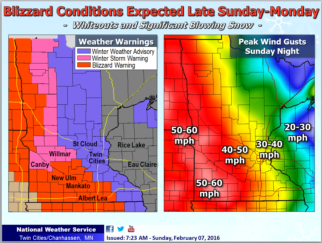
Blizzard Warnings are now in effect across south central Minnesota for late Sunday afternoon through Monday morning. Winter Storm Warnings are in effect across west central Minnesota.
A potent system will drop southeast from Canada Sunday, bringing periods of light snow and an inch or two of accumulation during the day. Behind it, very strong northwest winds gusting in excess of 40 to 55 mph are possible late Sunday into early Monday.
Given the deep snow cover from the winter storm earlier in the week across southern Minnesota and an inch of fresh accumulation, the wind will result in considerable blowing snow and whiteout conditions in those areas. Numerous road closures are possible.
Conditions are a bit more uncertain across western Minnesota where the snow pack is less condusive for blowing around. Because of this, Winter Storm Warnings are in place. If conditions become worse than currently expected, Blizzard Warnings may be issued there as well.
Where wind is not expected to be as strong, but blowing snow is still possible, a Winter Weather Advisory has been issued. That includes the Twin Cities.
Travel could become difficult or impossible in the Blizzard Warning areas by Sunday night.
548
WWUS43 KMPX 161138
WSWMPX
URGENT - WINTER WEATHER MESSAGE
National Weather Service Twin Cities/Chanhassen MN
638 AM CDT Mon Mar 16 2026
MNZ091>093-161500-
/O.EXP.KMPX.BZ.W.0004.000000T0000Z-260316T1200Z/
/O.EXB.KMPX.WW.Y.0012.000000T0000Z-260316T1500Z/
Martin-Faribault-Freeborn-
Including the cities of Blue Earth, Fairmont, and Albert Lea
638 AM CDT Mon Mar 16 2026
...WINTER WEATHER ADVISORY IN EFFECT UNTIL 10 AM CDT THIS MORNING...
...BLIZZARD WARNING WILL EXPIRE AT 7 AM CDT THIS MORNING...
* WHAT...Areas of blowing snow. Winds gusting as high as 40 mph.
* WHERE...Faribault, Freeborn, and Martin Counties.
* WHEN...Until 10 AM CDT this morning.
* IMPACTS...Blowing snow could significantly reduce visibility. The
hazardous conditions will impact the Monday morning commute.
PRECAUTIONARY/PREPAREDNESS ACTIONS...
Use caution while traveling, especially in open areas. Call 5 1 1 or
visit 511mn.org for road conditions.
&&
$$
MNZ073>078-083>085-WIZ026>028-161245-
/O.EXP.KMPX.WW.Y.0012.000000T0000Z-260316T1200Z/
Redwood-Brown-Nicollet-Le Sueur-Rice-Goodhue-Blue Earth-Waseca-
Steele-Pepin-Chippewa-Eau Claire-
Including the cities of Waseca, Durand, Redwood Falls, Le Sueur, St
Peter, Owatonna, Chippewa Falls, Mankato, Eau Claire, New Ulm,
Faribault, and Red Wing
638 AM CDT Mon Mar 16 2026
...WINTER WEATHER ADVISORY WILL EXPIRE AT 7 AM CDT THIS MORNING...
$$
MNZ082-161500-
/O.EXT.KMPX.WW.Y.0012.000000T0000Z-260316T1500Z/
Watonwan-
Including the cities of St James
638 AM CDT Mon Mar 16 2026
...WINTER WEATHER ADVISORY NOW IN EFFECT UNTIL 10 AM CDT THIS
MORNING...
* WHAT...Areas of blowing snow. Winds gusting as high as 40 mph.
* WHERE...Watonwan County.
* WHEN...Until 10 AM CDT this morning.
* IMPACTS...Blowing snow could significantly reduce visibility. The
hazardous conditions will impact the Monday morning commute.
PRECAUTIONARY/PREPAREDNESS ACTIONS...
Use caution while traveling, especially in open areas. Call 5 1 1 or
visit 511mn.org for road conditions.
&&
$$
Borghoff