Overview
|
A powerful, rapidly intensifying surface low developed over the Central Plains and tracked northeastward into the SW Great Lakes region. It drew deep moisture from Pacific sources & the Gulf allowing it to produce a widespread area of significant snowfall. As it wrapped in Arctic air, blizzard conditions developed on the back side of the system. Many areas saw 10–20+ inches, with isolated higher amounts (up to 2–3 feet in parts of west-central Wisconsin, Michigan's Upper Peninsula, and the Tip of the Mitten). The greatest snowfall amounts fell between the southern Twin Cities metro & Rochester and east into Wisconsin. Travel was severely impacted, including the stretch of I-94 between Eau Claire and Osseo where several vehicles became stranded during the blizzard conditions on Sunday (pictured below). For the Twin Cities, this was the biggest storm of the 2025-26 Winter with 8.9" reported at MSP Airport over the two days. Over 450 flights were cancelled or delayed at MSP Airport, impacting many travelers' Spring Break plans. |
.gif) Event Radar Loop: 10:30AM Saturday, March 14 to 3:00 Monday, March 16, 2026 |
 |
 |
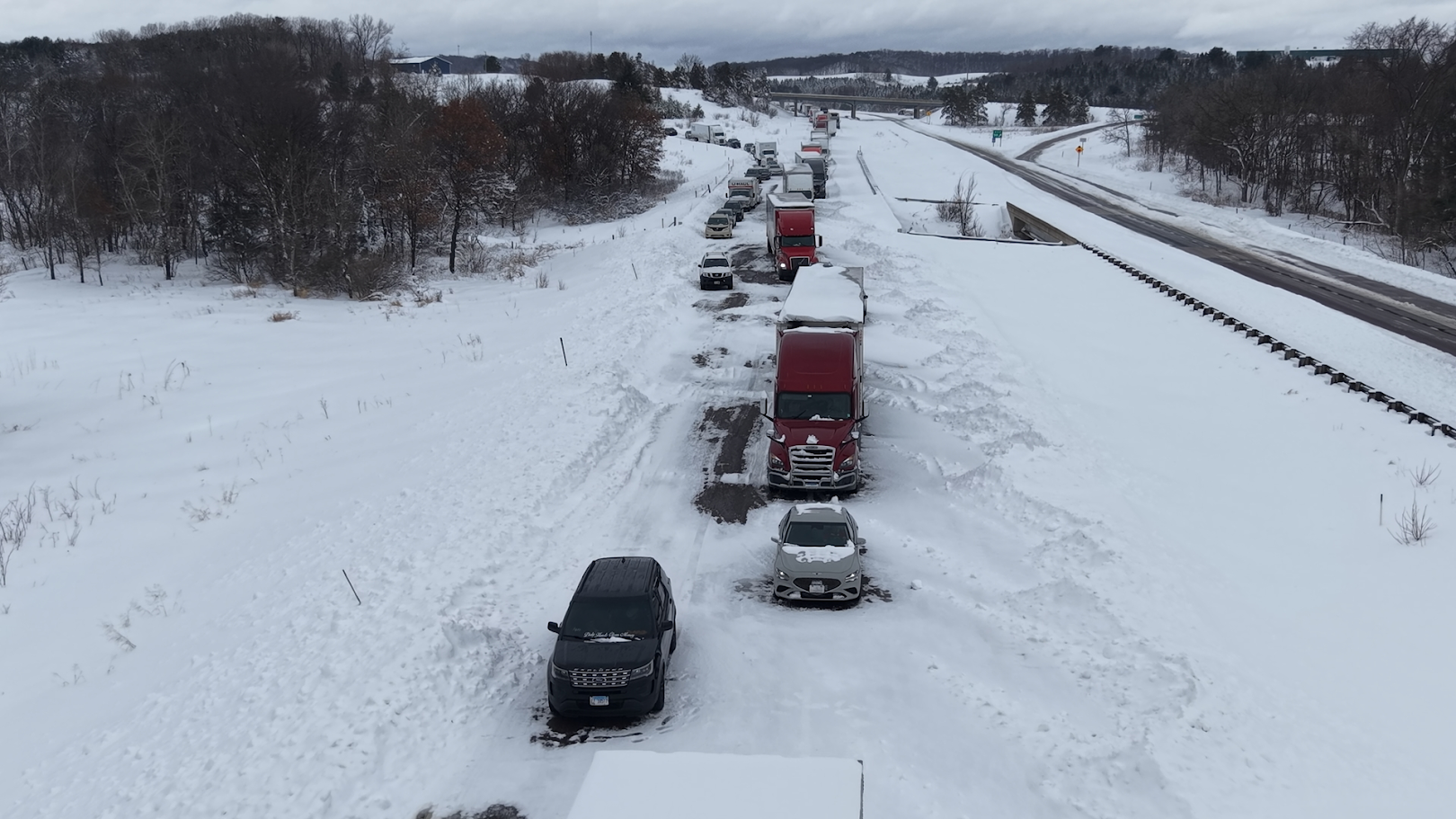 |
| Regional road conditions map from 9:00AM on Sunday, March 15th. All roads had become at least partially if not fully covered in snow, and travel advisories were put in place for much of southern MN. | Road condition update at 2:30PM on Sunday, March 15th courtesy of WIDOT. Travel advisories were in place for the entire northern half of the state as dangerous road conditions developed. | Several vehicles became stranded along I-94 south of Eau Claire near Osseo Sunday afternoon due to blizzard conditions. Photo courtesy of Aaron Rigsby. |
Snow Totals
Storm total snow is from 12pm Saturday, March 14th through 6am Monday, March 16th.
 |
 |
 |
| Regional map of snowfall reports. A band of 18+" stretched from SE Minnesota into much of central Wisconsin. | Local map and list of snowfall reports. Note: Additional reports were received after this report. Those new reports are included in the extended list below. | Snow report from Augusta, WI showing at least 20.5" courtesy of Jesse Joles. |
...HIGHEST SNOWFALL REPORTS FROM THE MARCH 14-15, 2026 BLIZZARD...

Location                     Amount    Time/Date       Provider

...Minnesota...

...Anoka County...
Ham Lake 2.0 NE              10.5 in   0700 AM 03/16   COCORAHS
1 N Fridley                  10.3 in   0700 AM 03/16   Trained Spotter
Blaine 2.7 WSW               10.0 in   0720 AM 03/16   COCORAHS
1 W Lino Lakes               9.4 in    0700 AM 03/16   COCORAHS
1 NW Coon Rapids             8.2 in    1200 PM 03/15   Trained Spotter

...Blue Earth County...
Mankato 1ESE                 11.0 in   0700 AM 03/16   COCORAHS

...Carver County...
1 WNW Carver                 11.8 in   0537 PM 03/15   Trained Spotter
0 N Chanhassen NWS           10.9 in   0100 AM 03/16   Official NWS Obs
2 WSW Victoria               10.8 in   0700 PM 03/15   Cocorahs
Victoria 1WSW                10.8 in   0700 AM 03/16   COCORAHS
Victoria 1.0 ENE             9.7 in    0700 AM 03/16   COCORAHS

...Chisago County...
Lindstrom                    8.6 in    0700 AM 03/16   COCORAHS

...Dakota County...
1 S Rosemount                16.9 in   0610 PM 03/15   Public
1 WNW Apple Valley           14.0 in   0430 PM 03/15   Trained Spotter
2 S Lakeville                14.0 in   0700 AM 03/16   Public
1 NNE Lakeville              13.2 in   0130 PM 03/15   Broadcast Media
Rosemount 3WNW               12.5 in   0700 AM 03/16   COCORAHS
Lakeville 3.2 SW             12.0 in   0700 AM 03/16   COCORAHS
2 N Apple Valley             11.9 in   1030 AM 03/15   Trained Spotter
Northfield 7.8 NNE           11.5 in   0700 AM 03/16   COCORAHS
Burnsville 2.3 E             11.3 in   0700 AM 03/16   COCORAHS
1 NNW Burnsville             11.0 in   0513 PM 03/15   Broadcast Media
1 S Eagan                    11.0 in   1015 PM 03/15   Trained Spotter
Eagan 1.1 S                  11.0 in   0800 AM 03/16   COCORAHS
3 ESE Eagan                  10.7 in   0200 AM 03/16
Farmington 5.5 ESE           10.5 in   0800 AM 03/16   COCORAHS
Eagan 1.9 W                  10.0 in   0806 AM 03/16   COCORAHS

...Faribault County...
Wells                        9.0 in    0800 AM 03/15   COOP
Winnebago                    8.0 in    1000 AM 03/15   COOP

...Freeborn County...
Albert Lea 3.4 SSE           10.0 in   0700 AM 03/16   COCORAHS
Albert Lea 1WSW              8.0 in    0730 AM 03/16   COCORAHS

...Goodhue County...
Pine Island                  16.0 in   0903 AM 03/15   Trained Spotter
Red Wing 4SE                 13.5 in   0800 AM 03/15   COCORAHS
Cannon Falls 0.5 SE          12.8 in   0800 AM 03/16   COCORAHS
Red Wing Lock and Dam        12.5 in   0600 AM 03/16   COOP
Vasa 5NNE                    12.2 in   0700 AM 03/15   COCORAHS
Zumbrota 0.6 E               12.0 in   1001 AM 03/15   COCORAHS
Red Wing                     11.5 in   0800 AM 03/15   COOP
Red Wing                     11.0 in   0756 AM 03/15   Trained Spotter
Nerstrand 4E                 10.3 in   0700 AM 03/16   COCORAHS
Dennison 2.0 NNE             10.2 in   0600 AM 03/16   COCORAHS

...Hennepin County...
3 N Savage                   14.0 in   1030 PM 03/15   Public
1 E Bloomington              12.0 in   1200 AM 03/16   Public
Richfield                    11.3 in   0800 PM 03/15
Bloomington                  10.6 in   0430 PM 03/15   Trained Spotter
3 SSW Hopkins                10.5 in   0700 AM 03/16   Trained Spotter
Minnetonka 3.8 SW            10.5 in   0800 AM 03/16   COCORAHS
1 ESE Richfield              10.4 in   1000 PM 03/15   Trained Spotter
2 SE Maple Grove             10.0 in   1109 AM 03/15   Public
Maple Grove 0.6 NNE          10.0 in   0526 AM 03/16   COCORAHS
Minneapolis Lower St. Anthon 10.0 in   0600 AM 03/16   COOP
Minneapolis 2.7 ESE          9.3 in    0705 AM 03/16   COCORAHS
Minneapolis 2.5 ESE          9.1 in    0700 AM 03/16   COCORAHS
MSP Airport                  8.9 in    0100 AM 03/16   Official NWS Obs

...Le Sueur County...
1 SE Kasota                  12.0 in   0710 PM 03/15
New Prague 1.0 S             10.0 in   1030 AM 03/15   COCORAHS
Le Center 5NNW               8.5 in    0800 AM 03/15   COCORAHS

...McLeod County...
Glencoe 3NW                  12.0 in   0700 AM 03/15   COCORAHS
2 WNW Hutchinson             10.5 in   0730 AM 03/16   COCORAHS
Hutchinson 5N                9.7 in    0700 AM 03/16   COCORAHS
Plato 0.3 ENE                9.6 in    0600 AM 03/15   COCORAHS
Glencoe                      8.0 in    0345 PM 03/15   Public

...Nicollet County...
St. Peter                    8.6 in    0430 PM 03/15   Public

...Ramsey County...
Shoreview 2.5 N              10.6 in   0600 AM 03/16   COCORAHS
Saint Paul 2.2 W             10.1 in   0800 AM 03/16   COCORAHS
Maplewood 5.6 SSE            9.6 in    0925 AM 03/15   COCORAHS

...Redwood County...
Belview 0.3 S                8.0 in    0800 AM 03/15   COCORAHS

...Rice County...
Faribault 1.2 W              12.7 in   0600 AM 03/16   COCORAHS
3 SSW Elko New Market        11.0 in   1100 AM 03/15   Trained Spotter
Northfield 0.4 SSW           10.5 in   0700 AM 03/16   COCORAHS
Northfield 0.6 ESE           9.0 in    0800 AM 03/15   COCORAHS
Montgomery 3ENE              9.0 in    0600 AM 03/16   COCORAHS
8 S Lonsdale                 8.0 in    0620 AM 03/15   Trained Spotter

...Scott County...
Elko New Market 1.2 W        14.8 in   0700 AM 03/16   COCORAHS
1 W Elko New Market          14.5 in   0402 PM 03/15   Cocorahs
Prior Lake 1WSW              14.5 in   0700 AM 03/16   COCORAHS
Savage 1.0 NNE               14.0 in   0700 AM 03/16   COCORAHS
2 WNW Prior Lake             13.7 in   1053 AM 03/15   Cocorahs
6 N Veseli                   12.5 in   0700 AM 03/16   COCORAHS
Savage                       10.5 in   1020 AM 03/15   Trained Spotter
New Prague 1.0 NNW           10.0 in   0700 AM 03/16   COCORAHS
Shakopee 2.6 W               9.0 in    0700 AM 03/16   COCORAHS

...Sherburne County...
1 ESE Big Lake               8.0 in    1241 PM 03/15

...Sibley County...
Henderson 0.4 N              12.5 in   0800 AM 03/16   COCORAHS
Winthrop                     9.0 in    0721 PM 03/15   Public

...Steele County...
Owatonna 1.0 ENE             13.0 in   0700 AM 03/16   COCORAHS
Owatonna 1.5 N               12.4 in   0700 AM 03/16   COCORAHS
Owatonna                     11.0 in   0800 AM 03/15   COOP
Ellendale 0.3 SW             9.7 in    0700 AM 03/16   COCORAHS
1 NW Ellendale               9.2 in    0954 AM 03/15   Emergency Mngr
Owatonna                     9.0 in    0720 AM 03/15   Trained Spotter

...Swift County...
Benson 0.1 SW                8.5 in    0700 AM 03/16   COCORAHS

...Waseca County...
Waseca 1.6 SSE               11.0 in   0800 AM 03/15   COCORAHS
1 SSW Waseca                 9.5 in    0952 AM 03/15   Broadcast Media
Waseca                       8.3 in    0635 AM 03/15   Broadcast Media

...Washington County...
Stillwater 1.8 SW            11.0 in   1020 AM 03/15   COCORAHS
Stillwater 0.8 SW            11.0 in   0730 AM 03/16   COCORAHS
Woodbury                     10.3 in   0739 PM 03/15   Public
Cottage Grove                10.2 in   0400 PM 03/15   Public
St Paul Park 0.6 NNE         9.7 in    0700 AM 03/16   COCORAHS
Woodbury 1.7 N               9.2 in    0700 AM 03/16   COCORAHS
Oakdale                      8.5 in    0940 AM 03/15   Public

...Wright County...
St. Michael 1E               8.4 in    0800 AM 03/16   COCORAHS

...Wisconsin...

...Barron County...
Rice Lake 6.9 WNW            11.2 in   0600 AM 03/16   COCORAHS
Haugen                       10.0 in   0556 PM 03/15

...Chippewa County...
6 W Cadott                   16.0 in   0418 PM 03/15   Public
Chippewa Falls 0.6 SSE       10.1 in   0700 AM 03/16   COCORAHS

...Dunn County...
Menomonie 3.3 SE             9.6 in    0700 AM 03/16   COCORAHS
Menomonie 0.9 SSE            8.8 in    0700 AM 03/16   COCORAHS
1 W Cedar Falls              8.0 in    0420 PM 03/15   Trained Spotter

...Eau Claire County...
3 ESE Augusta                20.5 in   0900 AM 03/15   Public
Eau Claire 7.8 SSE           15.2 in   0600 AM 03/16   COCORAHS
0 N Eau Claire               12.7 in   0100 AM 03/16   Official NWS Obs
8 SSW Altoona                12.5 in   1000 AM 03/15   Public
Eau Claire 3.7 S             10.8 in   0800 AM 03/15   COCORAHS
Eau Claire 5.4 SSE           10.5 in   0800 AM 03/15   COCORAHS
1 NW Eau Claire              9.8 in    0335 PM 03/15
2 WSW Altoona                9.5 in    0900 AM 03/15   Broadcast Media

...Pepin County...
Pepin                        19.0 in   0900 AM 03/15   Public
1 SE Durand                  18.5 in   0600 AM 03/16   Public
Durand                       16.5 in   0847 AM 03/15   Public
Stockholm 2NE                15.0 in   0800 AM 03/16   COCORAHS

...Rusk County...
Ladysmith 2WNW               8.0 in    0700 AM 03/16   COCORAHS

...St. Croix County...
River Falls 0.8 NNW          11.0 in   0900 AM 03/15   COCORAHS
Roberts                      11.0 in   0515 PM 03/15   Trained Spotter
1 E Hudson                   9.6 in    0800 AM 03/16   COCORAHS

Observations are collected from a variety of sources with varying
equipment and exposures. We thank all volunteer weather observers
for their dedication. Not all data listed are considered official.
Wind Gusts
 |
 |
| Regional map of maximum wind gusts for Sunday and Sunday night. The strongest winds were measured across southwest and south-central MN. | A 990mb low set up a very strong pressure gradient Sunday evening, resulting in strong winds across much of the region. The low would go on to deepen to near 984mb as it moved east over Michigan. |
...HIGHEST WIND REPORTS FROM THE MARCH 15, 2026 BLIZZARD...

Location                     Speed     Time/Date       Lat/Lon
Morris AP                    53 MPH    0435 PM 03/15   45.57N/95.97W
Appleton AP                  52 MPH    0455 PM 03/15   45.22N/96.00W
Madison AP                   51 MPH    0535 PM 03/15   44.98N/96.18W
Fairmont AP                  51 MPH    0716 PM 03/15   43.63N/94.42W
Redwood Falls AP             51 MPH    0730 PM 03/15   44.55N/95.08W
St. James AP                 49 MPH    0715 PM 03/15   43.98N/94.55W
Crystal AP                   49 MPH    1138 AM 03/15   45.07N/93.35W
Montevideo AP                48 MPH    0721 PM 03/15   44.97N/95.72W
Minneapolis-St. Paul AP      47 MPH    0106 AM 03/16   44.88N/93.23W
Willmar AP                   46 MPH    1055 AM 03/15   45.12N/95.13W
New Ulm AP                   46 MPH    0715 PM 03/15   44.32N/94.50W
Benson AP                    45 MPH    0535 PM 03/15   45.32N/95.65W
Eden Prairie AP              45 MPH    1133 AM 03/15   44.83N/93.47W
St. Cloud AP                 45 MPH    0834 PM 03/15   45.55N/94.05W
Waseca AP                    43 MPH    0935 PM 03/15   44.07N/93.55W
Menomonie AP                 43 MPH    1115 PM 03/15   44.90N/91.87W
Mankato AP                   43 MPH    0747 PM 03/15   44.22N/93.92W
Owatonna AP                  43 MPH    0519 PM 03/15   44.12N/93.25W
St. Paul Dwtn AP             43 MPH    1036 PM 03/15   44.93N/93.05W
Canby AP                     41 MPH    0515 PM 03/15   44.73N/96.27W
Granite Falls AP             41 MPH    0755 PM 03/15   44.75N/95.55W
Olivia AP                    41 MPH    0115 PM 03/15   44.78N/95.03W
Chetek AP                    41 MPH    1035 PM 03/15   45.30N/91.63W
Albert Lea AP                40 MPH    0823 PM 03/15   43.68N/93.37W
Buffalo AP                   40 MPH    0635 PM 03/15   45.17N/93.85W
Eau Claire AP                40 MPH    1219 AM 03/16   44.87N/91.47W
Maple Lake AP                40 MPH    0735 PM 03/15   45.23N/93.98W
Litchfield AP                39 MPH    0135 PM 03/15   45.10N/94.52W
Rice Lake AP                 39 MPH    0435 PM 03/15   45.42N/91.77W
Stanton AP                   39 MPH    0635 PM 03/15   44.47N/93.02W
Glenwood AP                  38 MPH    0901 AM 03/15   45.63N/95.32W
Hutchinson AP                38 MPH    0655 PM 03/15   44.87N/94.38W
Osceola AP                   38 MPH    1135 AM 03/15   45.32N/92.70W
Princeton AP                 38 MPH    1226 PM 03/15   45.57N/93.60W
Tony AP                      38 MPH    0355 AM 03/16   45.50N/91.00W
Sauk Centre AP               37 MPH    0415 PM 03/15   45.70N/94.93W
Glencoe AP                   37 MPH    0355 PM 03/15   44.77N/94.08W
Lakeville AP                 37 MPH    0715 PM 03/15   44.63N/93.23W
Paynesville AP               37 MPH    1055 AM 03/15   45.37N/94.73W
South St. Paul AP            37 MPH    1015 PM 03/15   44.87N/93.03W
Cambridge AP                 36 MPH    0118 PM 03/15   45.57N/93.27W
Faribault AP                 36 MPH    0515 PM 03/15   44.33N/93.32W
Rush City AP                 36 MPH    0135 PM 03/15   45.70N/92.95W
Cumberland AP                36 MPH    0615 PM 03/15   45.50N/91.98W
Red Wing AP                  35 MPH    1155 PM 03/15   44.58N/92.48W
New Richmond AP              35 MPH    0330 PM 03/15   45.15N/92.53W

Observations are collected from a variety of sources with varying
equipment and exposures. We thank all volunteer weather observers
for their dedication. Not all data listed are considered official.
Meteorological Summary
Upper Level Jet
The images below are from the Storm Prediction Center High Resolution Ensemble Forecast (HREF).
The top row shows the 500 mb geopotential heights (brown lines) and winds (barbs / color fill) from Saturday morning through Sunday night.
The bottom row is a surface map with mean sea level pressure (MSLP, black lines) and surface winds (brown wind barbs).
 |
 |
 |
| 500mb winds, valid at 8 AM Saturday, Mar 15, 2026 | 500mb winds, valid at 11 PM Saturday, Mar 15, 2026 | 500mb winds, valid at 7 PM Sunday, Mar 16, 2026 |
Surface Maps
The images below are from the Storm Prediction Center Mesoscale Analysis Archive.
 |
 |
 |
| Surface map, valid at 5 AM Saturday, Mar 15, 2026. The surface low is 992 mb. | Surface map, valid at 11 AM Saturday, Mar 15, 2026. The surface low is 994 mb. | Surface map, valid at 4 AM Sunday, Mar 16, 2026. The surface low is 984 mb. |
 |
Media use of NWS Web News Stories is encouraged! Please acknowledge the NWS as the source of any news information accessed from this site. |
|

