Overview
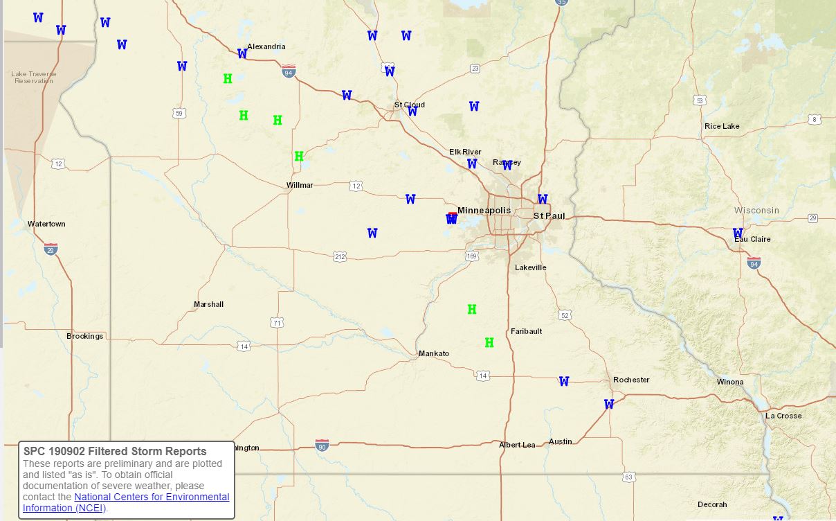
A strong line of thunderstorms moved southeast across west-central Minnesota, the Twin Cities metro, and west-central Wisconsin on the evening of September 2nd, 2019. The storms produced numerous wind damage reports and an EF1 tornado west of the Twin Cities. Most of the downburst wind damage reports were from tree damage along the I-94 corridor. A summary and a map of the reports can be seen below.
Tornadoes:
|
Tornado - 2 E Watertown, MN
Track Map  
|
||||||||||||||||
|
Tornado - 1 SW Howard Lake, MN
Track Map .JPG)
|
||||||||||||||||
The Enhanced Fujita (EF) Scale classifies tornadoes into the following categories:
| EF0 Weak 65-85 mph |
EF1 Moderate 86-110 mph |
EF2 Significant 111-135 mph |
EF3 Severe 136-165 mph |
EF4 Extreme 166-200 mph |
EF5 Catastrophic 200+ mph |
 |
|||||
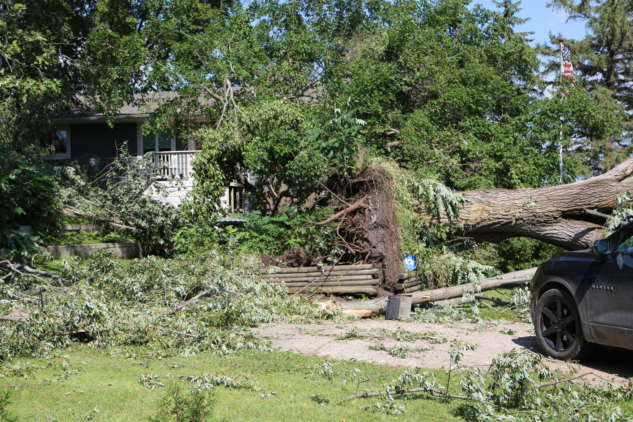
Photos
The photos below are from the EF-1 tornado that occurred from just east of Watertown into the Minnetrista area on the night of September 2nd, 2019.
.jpg) |
.jpg) |
 |
 |
| Damage from the Carver/Hennepin County EF-1 Tornado | Damage from the Carver/Hennepin County EF-1 Tornado | Damage from the Carver/Hennepin County EF-1 Tornado | Damage from the Carver/Hennepin County EF-1 Tornado |
Storm Reports
..TIME...   ...EVENT...      ...CITY LOCATION...     ...LAT.LON...
..DATE...   ....MAG....      ..COUNTY LOCATION..ST.. ...SOURCE....
            ..REMARKS..

1101 PM     TSTM WND DMG     2 NE HAMMOND            45.00N 92.41W
09/02/2019                   ST. CROIX          WI   PUBLIC

            REPORT FROM MPING: 1-INCH TREE LIMBS BROKEN;
            SHINGLES BLOWN OFF.

1046 PM     HEAVY RAIN       1 NE ROBERTS            45.00N 92.54W
09/02/2019  M3.00 INCH       ST. CROIX          WI   PUBLIC


1148 PM     TSTM WND GST     4 NNE EAU CLAIRE        44.87N 91.47W
09/02/2019  M59 MPH          CHIPPEWA           WI   ASOS

            ASOS STATION KEAU EAU CLAIRE AP.

1146 PM     TSTM WND DMG     1 NW CHIPPEWA FALLS     44.94N 91.40W
09/02/2019                   CHIPPEWA           WI   PUBLIC

            REPORT FROM MPING: 1-INCH TREE LIMBS BROKEN;
            SHINGLES BLOWN OFF.

1000 PM     TSTM WND GST     2 SE OTSEGO             45.26N 93.58W
09/02/2019  M62 MPH          WRIGHT             MN   COCORAHS


0954 PM     TSTM WND GST     HOWARD LAKE             45.06N 94.07W
09/02/2019  M64 MPH          WRIGHT             MN   MESONET

            HENNEPIN WEST MESONET SITE AT HOWARD LAKE.

0940 PM     TSTM WND GST     2 SE CLEARWATER         45.39N 94.03W
09/02/2019  M52 MPH          WRIGHT             MN   MESONET

            MESONET STATION MN017 CLEARWATER 1SE.

1142 PM     TSTM WND DMG     1 SW STILLWATER         45.05N 92.84W
09/02/2019                   WASHINGTON         MN   PUBLIC

            REPORT FROM MPING: 1-INCH TREE LIMBS BROKEN;
            SHINGLES BLOWN OFF.

1038 PM     TSTM WND GST     6 W CLEARWATER          45.42N 94.17W
09/02/2019  M61 MPH          STEARNS            MN   PUBLIC


0957 PM     TSTM WND GST     7 W CLEARWATER          45.42N 94.19W
09/02/2019  M63 MPH          STEARNS            MN   PUBLIC


0936 PM     TSTM WND DMG     KIMBALL                 45.32N 94.30W
09/02/2019                   STEARNS            MN   PUBLIC

            REPORT FROM MPING: 1-INCH TREE LIMBS BROKEN;
            SHINGLES BLOWN OFF.

0936 PM     TSTM WND DMG     1 W SARTELL             45.63N 94.22W
09/02/2019                   STEARNS            MN   PUBLIC

            REPORT FROM MPING: 1-INCH TREE LIMBS BROKEN;
            SHINGLES BLOWN OFF.

0934 PM     TSTM WND GST     6 SE PLEASANT LAKE      45.43N 94.19W
09/02/2019  M63 MPH          STEARNS            MN   PUBLIC


0926 PM     TSTM WND DMG     5 NE KIMBALL            45.39N 94.26W
09/02/2019                   STEARNS            MN   PUBLIC


0925 PM     TSTM WND GST     6 SE PLEASANT LAKE      45.42N 94.21W
09/02/2019  M63 MPH          STEARNS            MN   PUBLIC


0915 PM     TSTM WND DMG     2 W RICE                45.74N 94.26W
09/02/2019                   STEARNS            MN   PUBLIC

            REPORT FROM MPING: TREES UPROOTED OR
            SNAPPED; ROOF BLOWN OFF.

0915 PM     TSTM WND GST     6 SE PLEASANT LAKE      45.42N 94.21W
09/02/2019  M62 MPH          STEARNS            MN   PUBLIC


0911 PM     TSTM WND DMG     2 W RICE                45.74N 94.26W
09/02/2019                   STEARNS            MN   PUBLIC

            REPORT FROM MPING: 3-INCH TREE LIMBS BROKEN;
            POWER POLES BROKEN.

0901 PM     TSTM WND DMG     ALBANY                  45.64N 94.57W
09/02/2019                   STEARNS            MN   PUBLIC

            REPORT FROM MPING: 1-INCH TREE LIMBS BROKEN;
            SHINGLES BLOWN OFF.

0855 PM     HAIL             BELGRADE                45.45N 95.00W
09/02/2019  M1.00 INCH       STEARNS            MN   PUBLIC

            GAZEBO ALSO BLOWN UP AGAINST HOUSE.

0843 PM     HAIL             BROOTEN                 45.50N 95.12W
09/02/2019  E1.75 INCH       STEARNS            MN   PUBLIC

            WIND DRIVEN HAIL DAMAGE.

0927 PM     TSTM WND GST     6 E ST. CLOUD           45.55N 94.05W
09/02/2019  M58 MPH          SHERBURNE          MN   ASOS

            ASOS STATION KSTC ST. CLOUD AP.

1038 PM     HAIL             1 E BELLE PLAINE        44.63N 93.76W
09/02/2019  U0.50 INCH       SCOTT              MN   PUBLIC

            REPORT FROM MPING: HALF-INCH (0.50 IN.).

1129 PM     HAIL             5 SW FARIBAULT          44.23N 93.30W
09/02/2019  U0.50 INCH       RICE               MN   PUBLIC

            REPORT FROM MPING: HALF-INCH (0.50 IN.).

1115 PM     HAIL             2 N MORRISTOWN          44.25N 93.44W
09/02/2019  M1.00 INCH       RICE               MN   PUBLIC


1053 PM     TSTM WND DMG     1 E NORTH ST. PAUL      45.01N 92.99W
09/02/2019                   RAMSEY             MN   PUBLIC

            REPORT FROM MPING: 1-INCH TREE LIMBS BROKEN;
            SHINGLES BLOWN OFF.

1028 PM     TSTM WND DMG     WHITE BEAR LAKE         45.06N 93.02W
09/02/2019                   RAMSEY             MN   LAW ENFORCEMENT

            MULTIPLE TREES DOWN.

0833 PM     HAIL             7 NW SUNBURG            45.42N 95.34W
09/02/2019  M1.00 INCH       POPE               MN   TRAINED SPOTTER


0825 PM     HAIL             8 S GLENWOOD            45.53N 95.39W
09/02/2019  M1.00 INCH       POPE               MN   TRAINED SPOTTER


0813 PM     HAIL             2 N LOWRY               45.73N 95.52W
09/02/2019  M1.00 INCH       POPE               MN   COUNTY OFFICIAL


0912 PM     TSTM WND DMG     PIERZ                   45.97N 94.10W
09/02/2019                   MORRISON           MN   PUBLIC

            ROOF BLOWN OFF OF A BUILDING SOUTH OF PIERZ.
            TIME ESTIMATED.

0858 PM     TSTM WND DMG     LITTLE FALLS            45.97N 94.37W
09/02/2019                   MORRISON           MN   PUBLIC

            NUMEROUS TREES DOWN ACROSS LITTLE FALLS.

0942 PM     TSTM WND DMG     2 ENE PRINCETON         45.58N 93.56W
09/02/2019                   MILLE LACS         MN   EMERGENCY MNGR

            SCATTERED TREES DOWN.

0928 PM     HAIL             LITCHFIELD              45.12N 94.53W
09/02/2019  M0.70 INCH       MEEKER             MN   TRAINED SPOTTER


0923 PM     HAIL             5 S LITCHFIELD          45.04N 94.51W
09/02/2019  U0.50 INCH       MEEKER             MN   PUBLIC

            REPORT FROM MPING: HALF-INCH (0.50 IN.).

0921 PM     HAIL             1 NE LITCHFIELD         45.13N 94.52W
09/02/2019  U0.50 INCH       MEEKER             MN   PUBLIC

            REPORT FROM MPING: HALF-INCH (0.50 IN.).

0937 PM     TSTM WND DMG     2 S HUTCHINSON          44.87N 94.37W
09/02/2019                   MCLEOD             MN   EMERGENCY MNGR

            TREE BRANCH DOWN ON POWER LINE. TREE IS ON
            FIRE. TIME ESTIMATED FROM RADAR.

0659 AM     TSTM WND DMG     LE SUEUR                44.46N 93.90W
09/03/2019                   LE SUEUR           MN   PUBLIC

            REPORT FROM MPING: 1-INCH TREE LIMBS BROKEN;
            SHINGLES BLOWN OFF.

1100 PM     HAIL             MONTGOMERY              44.44N 93.58W
09/02/2019  M1.00 INCH       LE SUEUR           MN   LAW ENFORCEMENT


1052 PM     TSTM WND DMG     1 N MONTGOMERY          44.46N 93.58W
09/02/2019                   LE SUEUR           MN   PUBLIC

            REPORT FROM MPING: TREES UPROOTED OR
            SNAPPED; ROOF BLOWN OFF.

1048 PM     HAIL             1 N MONTGOMERY          44.46N 93.58W
09/02/2019  U0.50 INCH       LE SUEUR           MN   PUBLIC

            REPORT FROM MPING: HALF-INCH (0.50 IN.).

0910 PM     HAIL             4 E NEW LONDON          45.33N 94.87W
09/02/2019  U0.50 INCH       KANDIYOHI          MN   PUBLIC

            REPORT FROM MPING: HALF-INCH (0.50 IN.).

0900 PM     HAIL             5 NE WILLMAR            45.18N 95.00W
09/02/2019  U0.50 INCH       KANDIYOHI          MN   PUBLIC

            REPORT FROM MPING: HALF-INCH (0.50 IN.).

0854 PM     HAIL             NEW LONDON              45.30N 94.95W
09/02/2019  M1.75 INCH       KANDIYOHI          MN   COUNTY OFFICIAL


1133 PM     TSTM WND DMG     3 NNE ST. BONIFACIUS    44.95N 93.73W
09/02/2019                   HENNEPIN           MN   TRAINED SPOTTER

            SPOTTERS REPORTED TREE DOWN ON HOUSE AND
            TREES BLOCKING THE ROAD. RADAR CONFIRMED
            TORNADO WAS IN THE VICINITY.

1013 PM     HEAVY RAIN       1 NW ROGERS             45.21N 93.57W
09/02/2019  M1.10 INCH       HENNEPIN           MN   PUBLIC


1012 PM     TSTM WND DMG     3 N ST. BONIFACIUS      44.95N 93.75W
09/02/2019                   HENNEPIN           MN   STORM CHASER

            POWER LINES AND TREE BRANCHES DOWN. TIME
            ESTIMATED FROM RADAR.

1010 PM     TORNADO          4 WNW MOUND             44.96N 93.73W
09/02/2019                   HENNEPIN           MN   OFFICIAL NWS OBS

            RADAR CONFIRMED TORNADO BETWEEN ST.
            BONIFACIUS AND MAPLE PLAIN.

1005 PM     TSTM WND GST     2 W ANOKA               45.20N 93.42W
09/02/2019  M56 MPH          HENNEPIN           MN   MESONET

            DAYTON MESONET SITE AT PUBLIC WORKS
            BUILDING.

1000 PM     TSTM WND DMG     1 NW ROGERS             45.21N 93.57W
09/02/2019                   HENNEPIN           MN   PUBLIC


0821 PM     HAIL             2 NNE FARWELL           45.78N 95.60W
09/02/2019  M0.88 INCH       DOUGLAS            MN   TRAINED SPOTTER


0813 PM     TSTM WND GST     2 SW ALEXANDRIA         45.87N 95.40W
09/02/2019  M63 MPH          DOUGLAS            MN   ASOS

            ASOS STATION KAXN ALEXANDRIA AP.

1137 PM     HEAVY RAIN       1 N WEST ST. PAUL       44.92N 93.08W
09/02/2019  M0.52 INCH       DAKOTA             MN   PUBLIC


1008 PM     HAIL             1 E NORWOOD/YOUNG AMERI 44.78N 93.90W
09/02/2019  U0.50 INCH       CARVER             MN   PUBLIC

            REPORT FROM MPING: HALF-INCH (0.50 IN.).

0927 PM     TSTM WND DMG     SAUK RAPIDS             45.59N 94.17W
09/02/2019                   BENTON             MN   PUBLIC

            REPORT FROM MPING: 1-INCH TREE LIMBS BROKEN;
            SHINGLES BLOWN OFF.

0926 PM     FLASH FLOOD      SAUK RAPIDS             45.59N 94.17W
09/02/2019                   BENTON             MN   PUBLIC

            REPORT FROM MPING: STREET/ROAD FLOODING;
            STREET/ROAD CLOSED; VEHICLES STRANDED.

0911 PM     TSTM WND GST     1 N RICE                45.77N 94.23W
09/02/2019  M65 MPH          BENTON             MN   MESONET

            MESONET STATION MN064 RICE 1NNW.

1212 AM     TSTM WND DMG     1 W BLAINE              45.17N 93.25W
09/03/2019                   ANOKA              MN   PUBLIC

            REPORT FROM MPING: TREES UPROOTED OR
            SNAPPED; ROOF BLOWN OFF.

1131 PM     TSTM WND DMG     2 SE HAM LAKE           45.23N 93.22W
09/02/2019                   ANOKA              MN   PUBLIC

            REPORT FROM MPING: 3-INCH TREE LIMBS BROKEN;
            POWER POLES BROKEN.

1030 PM     FLASH FLOOD      2 NW COON RAPIDS        45.17N 93.30W
09/02/2019                   ANOKA              MN   PUBLIC

            REPORT FROM MPING: STREET/ROAD FLOODING;
            STREET/ROAD CLOSED; VEHICLES STRANDED.

1022 PM     HAIL             1 NE BLAINE             45.18N 93.22W
09/02/2019  U0.50 INCH       ANOKA              MN   PUBLIC

            REPORT FROM MPING: HALF-INCH (0.50 IN.).

1022 PM     TSTM WND DMG     3 NNE CIRCLE PINES      45.19N 93.14W
09/02/2019                   ANOKA              MN   PUBLIC

            MULTIPLE TREES DOWN, SOME UPROOTED. TIME
            ESTIMATED.

1012 PM     TSTM WND DMG     COON RAPIDS             45.17N 93.29W
09/02/2019                   ANOKA              MN   PUBLIC

            REPORT OF TREE DAMAGE WITH POWER LINES DOWN.
            TIME ESTIMATED FROM RADAR.

1008 PM     TSTM WND DMG     ANDOVER                 45.25N 93.30W
09/02/2019                   ANOKA              MN   PUBLIC

            PHOTOS FROM TWITTER OF LARGER TREE BRANCHES
            DOWN AND TREE DAMAGE IN THE TOWN OF ANDOVER.
            TIME ESTIMATED FROM RADAR.
 |
Media use of NWS Web News Stories is encouraged! Please acknowledge the NWS as the source of any news information accessed from this site. |
|

