
Hurricane Erin continues to track westward with its outer bands bringing heavy rainfall and gusty winds for Puerto Rico and US Virgin Islands. Life-threatening surf and rip currents are occurring and will spread across the Atlantic coasts this week. Meanwhile, heavy rainfall and possible flooding are in the forecast for upper Midwest through Monday. Heatrisk continues for the Mississippi Valley. Read More >
Overview
During the morning of Thursday, January 14th, a weak frontal boundary bisected the eastern half of Minnesota. To the east, warm temperatures remained with the southwest part of Minnesota temperatures started to fall into the 20s. By Thursday evening, an area of low pressure developed across northeast Iowa and intensified as it moved slowly southward across eastern Iowa.
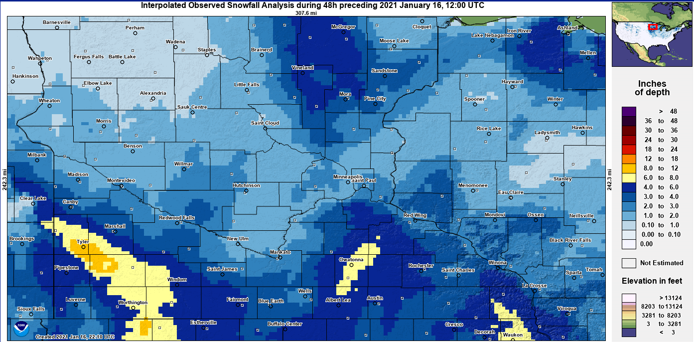
There was a prolonged period of warm air advection across most of Minnesota and western Wisconsin. The coldest temperatures remained across the far southwest part of Minnesota where the strongest winds occurred. As temperatures remained near the freezing mark over most of MPX forecast area Thursday, Thursday night and Friday, a lot of the snow either mixed with rain, or melted. Only when snowfall rates increased did any of the snowfall accumulate. Most of the heavier snowfall occurred Thursday night/Early Friday morning, with a band of heavier snowfall over south central Minnesota. An area of 6 to 8 inches fell in this area from western Goodhue County, southward toward Albert Lea in Freeborn County. Besides this area, most of the snowfall ranged from 1 to 3 inches, with locally 3 to 5 inches around Lake Mille Lacs and from the southern Twin Cities to the Iowa border.
Blizzard conditions were felt over mainly the far southwest part of Minnesota where both temperatures fell into the 20s, and wind gusts of 40 to 60 mph occurred. Communities from Montevideo southeast along the Minnesota River Valley, and toward the Iowa border did managed to fall into the upper 20s as snow and strong winds developed Thursday night. This allowed for blizzard conditions for a small portion of Yellow Medicine, Redwood, Watonwan and Martin Counties. Elsewhere, and as even winds gusted to 30 to 50 mph, blizzard conditions were isolated and weren't prolonged. There were numerous road closures in west central to southwest Minnesota, but MnDOT webcams and roads were mainly ice covered vs. snow covered, with whiteout conditions.
Radar
 |
 |
 |
 |
|
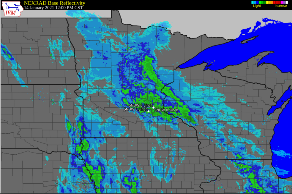
12:00 PM Jan 14 (Early Snowfall, Mainly Light) |
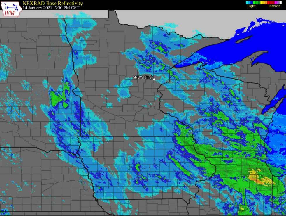
5:45 PM Jan 14 (Temporary End Of the Snowfall) |
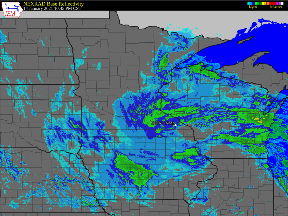
10:45 PM Jan 14 (Snowfall Increases from the SE, wrapping into SE MN) |
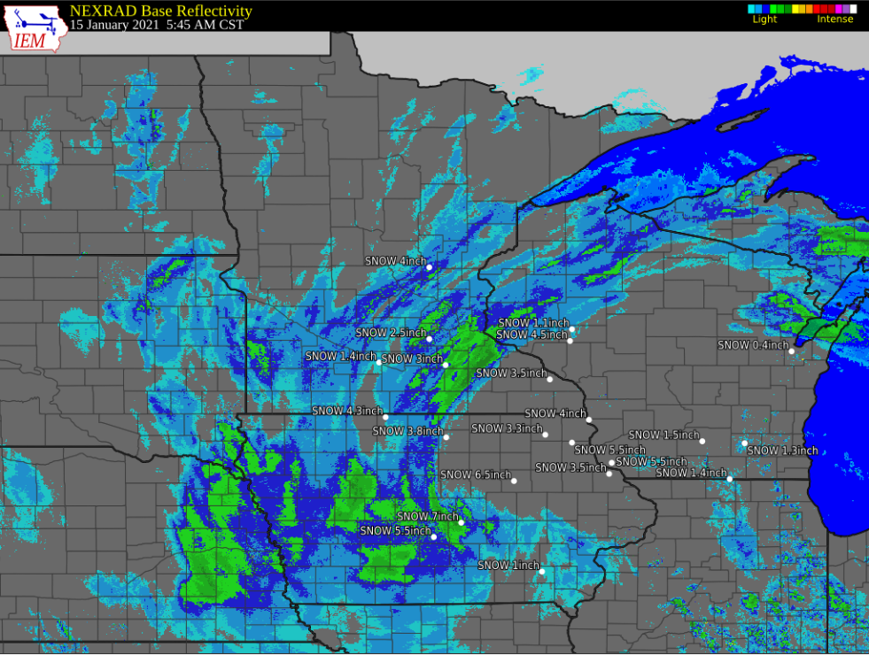
5:45 AM Jan 15 (Bands of Heavier Snowfall Early Friday Morning in SC Mn) |
Storm Reports
Interpolated Observed Snowfall Amounts (Courtesy of National Operational Hydrologic Remote Sensing Center)
Selected Reports from Media, Trained Observers and/or Public (> 3.0")
0700 AM Snow ELLENDALE 43.87N 93.30W
01/15/2021 M8.2 inch Steele MN Cocorahs
0200 PM Snow OWATONNA 44.09N 93.22W
01/15/2021 E8.0 inch Steele MN Broadcast Media
0200 PM Snow ALDEN 43.67N 93.58W
01/15/2021 E8.0 inch Freeborn MN Broadcast Media
0900 AM Snow 2 N SPENCER BROOK 45.56N 93.45W
01/15/2021 M7.5 inch Isanti MN Cocorahs
0200 PM Snow CLARKS GROVE 43.76N 93.33W
01/15/2021 E6.5 inch Freeborn MN Broadcast Media
0800 AM Snow 1 NNW OWATONNA 44.10N 93.23W
01/15/2021 M6.5 inch Steele MN CO-OP Observer
0700 AM Snow 4 E NERSTRAND 44.34N 92.98W
01/15/2021 M6.1 inch Goodhue MN Cocorahs
0700 AM Snow 1 NNE OWATONNA 44.10N 93.21W
01/15/2021 M6.0 inch Steele MN Cocorahs
0700 AM Snow 1 SW ALBERT LEA 43.64N 93.39W
01/15/2021 M6.0 inch Freeborn MN Cocorahs
0630 AM Snow 2 S ZUMBROTA 44.27N 92.67W
01/15/2021 M6.0 inch Goodhue MN Broadcast Media
0800 AM Snow 7 WSW VINELAND 46.13N 93.89W
01/15/2021 M5.5 inch Morrison MN Cocorahs
0800 AM Snow 1 SSE WASECA 44.06N 93.49W
01/15/2021 M5.5 inch Waseca MN Cocorahs
0733 AM Snow 1 S Waseca 44.07N 93.50W
01/15/2021 M5.5 inch Waseca MN Public
0700 AM Snow 2 NNE DENNISON 44.43N 93.02W
01/15/2021 M5.5 inch Goodhue MN Cocorahs
0200 PM Snow GLENVILLE 43.57N 93.28W
01/15/2021 E5.0 inch Freeborn MN Broadcast Media
0900 AM Snow 1 E PINE ISLAND 44.21N 92.63W
01/15/2021 M5.0 inch Goodhue MN Broadcast Media
0800 AM Snow 1 WSW WASECA 44.07N 93.53W
01/15/2021 M5.0 inch Waseca MN CO-OP Observer
0700 AM Snow 1 SSW FARIBAULT 44.28N 93.27W
01/15/2021 M5.0 inch Rice MN Cocorahs
0700 AM Snow 2 SW Bricelyn 43.54N 93.84W
01/15/2021 M4.8 inch Faribault MN CO-OP Observer
0845 AM Snow 1 E CANNON FALLS 44.51N 92.89W
01/15/2021 M4.7 inch Goodhue MN Broadcast Media
0845 AM Snow 1 NW FARMINGTON 44.64N 93.15W
01/15/2021 M4.5 inch Dakota MN Broadcast Media
0800 AM Snow 3 NE STOCKHOLM 44.52N 92.22W
01/15/2021 M4.5 inch Pepin WI Cocorahs
0700 AM Snow 1 NNW NEW PRAGUE 44.56N 93.58W
01/15/2021 M4.5 inch Scott MN Cocorahs
0700 AM Snow 1 SW APPLE VALLEY 44.71N 93.23W
01/15/2021 M4.5 inch Dakota MN Cocorahs
0700 AM Snow 2 SW ROSEMOUNT 44.72N 93.15W
01/15/2021 M4.5 inch Dakota MN Cocorahs
0633 AM Snow 4 WSW AUSTIN 43.64N 93.05W
01/15/2021 M4.5 inch Freeborn MN Public
0535 AM Snow 13 S ALTOONA 44.62N 91.48W
01/15/2021 M4.5 inch Eau Claire WI Cocorahs
0700 AM Snow 1 ENE Burnsville 44.76N 93.27W
01/15/2021 M4.4 inch Dakota MN Cocorahs
0800 AM Snow 3 NNW GLENVILLE 43.61N 93.30W
01/15/2021 M4.2 inch Freeborn MN CO-OP Observer
0700 AM Snow 5 N VASA 44.58N 92.70W
01/15/2021 M4.2 inch Goodhue MN Cocorahs
1232 PM Snow 1 E Mankato 44.17N 93.97W
01/15/2021 M4.0 inch Blue Earth MN Public
0830 AM Snow 1 SW MILACA 45.75N 93.66W
01/15/2021 M4.0 inch Mille Lacs MN CO-OP Observer
0800 AM Snow 1 WNW Winnebago 43.77N 94.19W
01/15/2021 M4.0 inch Faribault MN CO-OP Observer
0800 AM Snow 1 NE FARIBAULT 44.30N 93.26W
01/15/2021 M4.0 inch Rice MN Cocorahs
0700 AM Snow 3 NNE ROSEMOUNT 44.78N 93.10W
01/15/2021 M4.0 inch Dakota MN Cocorahs
0700 AM Snow 1 ENE FARIBAULT 44.30N 93.25W
01/15/2021 M4.0 inch Rice MN Cocorahs
0700 AM Snow MANKATO 44.17N 93.99W
01/15/2021 M4.0 inch Blue Earth MN County Official
0635 AM Snow 4 SSW EAGAN 44.79N 93.17W
01/15/2021 M4.0 inch Dakota MN Public
0630 AM Snow 4 NW ONAMIA 46.11N 93.74W
01/15/2021 M4.0 inch Mille Lacs MN Cocorahs
0545 AM Snow 1 SE MILACA 45.75N 93.64W
01/15/2021 M4.0 inch Mille Lacs MN Broadcast Media
0520 AM Snow 2 W LAKEVILLE 44.68N 93.28W
01/15/2021 M4.0 inch Dakota MN Broadcast Media
0900 AM Snow NORTHFIELD 44.45N 93.16W
01/15/2021 M3.9 inch Rice MN Cocorahs
1000 AM Snow 2 N BLAINE 45.20N 93.23W
01/15/2021 M3.5 inch Anoka MN Cocorahs
0830 AM Snow 4 S CLEAR LAKE 45.19N 92.28W
01/15/2021 M3.5 inch St. Croix WI Cocorahs
0800 AM Snow 2 ESE SKYLINE 44.13N 94.01W
01/15/2021 M3.5 inch Blue Earth MN Cocorahs
0700 AM Snow OAKDALE 44.98N 92.97W
01/15/2021 M3.5 inch Washington MN Cocorahs
0800 AM Snow 7 SSE BIRD ISLAND 44.67N 94.85W
01/15/2021 M3.4 inch Renville MN Cocorahs
0631 AM Snow 3 NE NORTHFIELD 44.48N 93.13W
01/15/2021 M3.4 inch Dakota MN Cocorahs
0630 AM Snow 3 NE NORTHFIELD 44.49N 93.13W
01/15/2021 M3.4 inch Dakota MN Cocorahs
0700 AM Snow 1 E DUNDAS 44.43N 93.17W
01/15/2021 M3.3 inch Rice MN Cocorahs
0800 AM Snow 1 ESE NEW PRAGUE 44.54N 93.57W
01/15/2021 M3.2 inch Le Sueur MN Cocorahs
0700 AM Snow 3 E COATES 44.72N 92.97W
01/15/2021 M3.1 inch Dakota MN Cocorahs
0700 AM Snow 2 WNW PRIOR LAKE 44.71N 93.46W
01/15/2021 M3.1 inch Scott MN Cocorahs
0700 AM Snow 3 WSW PLYMOUTH 45.00N 93.51W
01/15/2021 M3.1 inch Hennepin MN Cocorahs
0700 PM Snow 1 S EXCELSIOR 44.89N 93.56W
01/15/2021 E3.0 inch Carver MN Public
1045 AM Snow 2 W New Prague 44.55N 93.62W
01/15/2021 M3.0 inch Scott MN Cocorahs
0800 AM Snow 3 NW BETHEL 45.44N 93.30W
01/15/2021 M3.0 inch Isanti MN Cocorahs
0730 AM Snow 1 WSW BALDWIN 44.96N 92.39W
01/15/2021 M3.0 inch St. Croix WI CO-OP Observer
0705 AM Snow 2 SE APPLE VALLEY 44.70N 93.18W
01/15/2021 M3.0 inch Dakota MN Cocorahs
0700 AM Snow 1 NW NORTH ST. PAUL 45.02N 93.01W
01/15/2021 M3.0 inch Ramsey MN Cocorahs
0700 AM Snow 3 NNE RAMSEY 45.30N 93.43W
01/15/2021 M3.0 inch Anoka MN Cocorahs
0700 AM Snow 2 SSE OAKDALE 44.95N 92.95W
01/15/2021 M3.0 inch Washington MN Cocorahs
0700 AM Snow 1 E BLUE EARTH 43.64N 94.09W
01/15/2021 M3.0 inch Faribault MN Cocorahs
0606 AM Snow MAPLE PLAIN 45.01N 93.66W
01/15/2021 M3.0 inch Hennepin MN Trained Spotter
0600 AM Snow 3 WNW ANDOVER 45.26N 93.36W
01/15/2021 M3.0 inch Anoka MN Cocorahs
0530 AM Snow 3 NE MORRISTOWN 44.25N 93.39W
01/15/2021 M3.0 inch Rice MN Broadcast Media
0430 AM Snow 4 NE MONTGOMERY 44.47N 93.52W
01/15/2021 M3.0 inch Rice MN Cocorahs
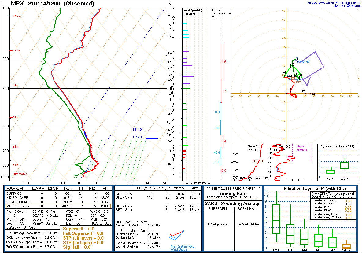
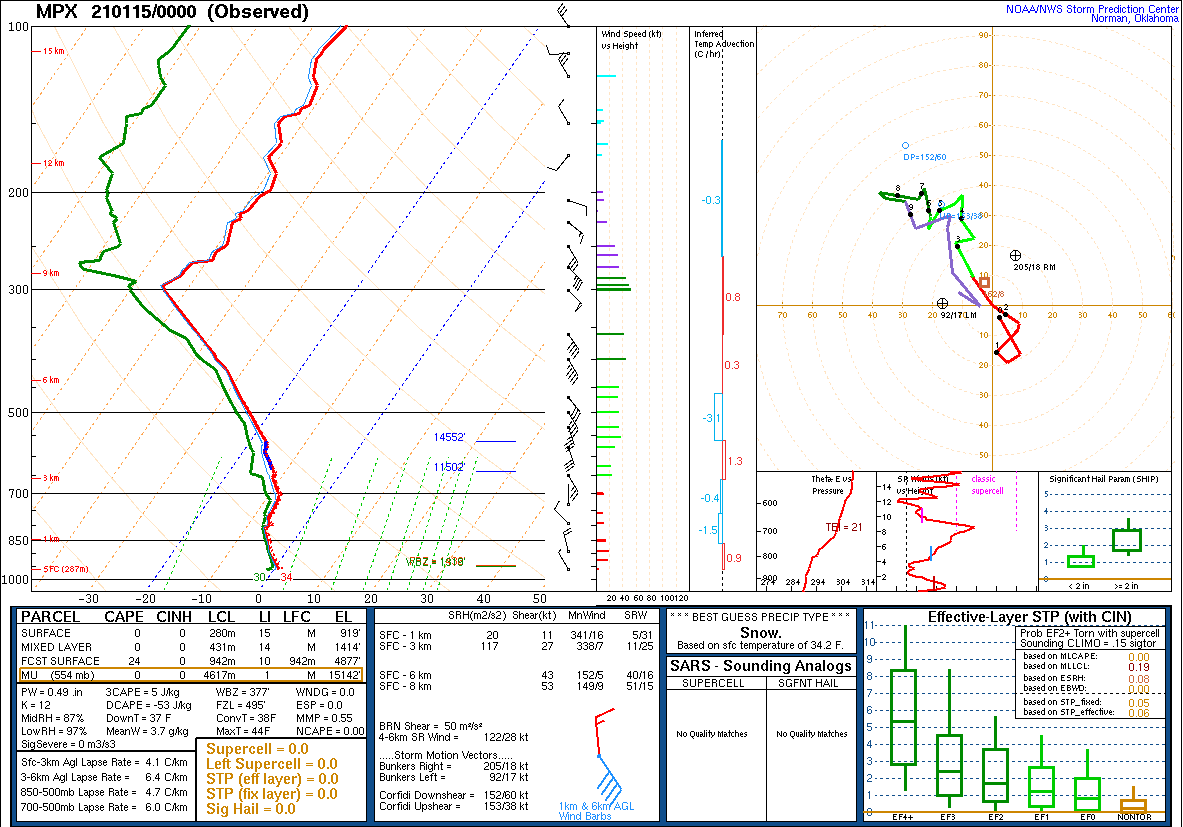
Environment
Atmospheric Sounding during the storm system.
 |
 |
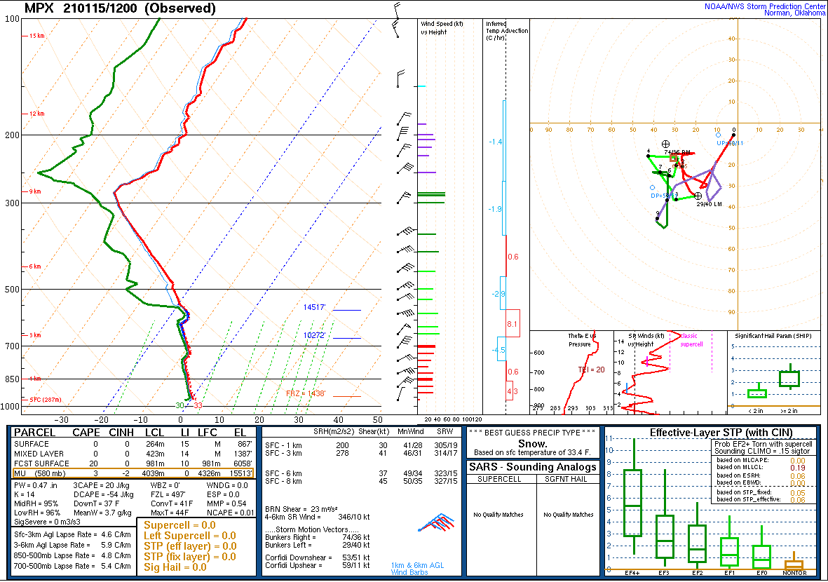 |
| MPX - Sounding 12Z January 14, 2021 | MPX - Sounding 00Z January 15, 2021 | MPX - Sounding 12Z January 15, 2012 |
Overview of the synoptic scale system and how warm it was below 850 MB
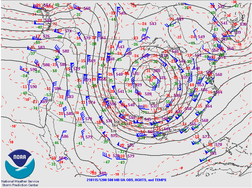 |
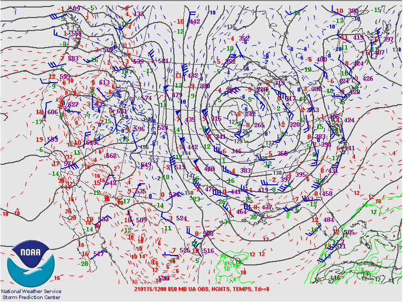 |
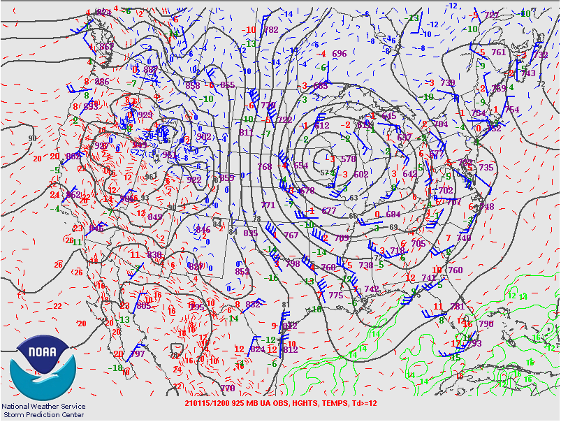 |
| 500 MB - Strong Upper Low 12Z Fri 15 | 850 MB - (-4C @ MPX) 12Z Fri 15 | 925 MB - (-1C @ MPX) 12Z Fri 15 |
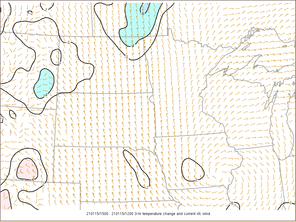
Additional environmental data. This correlates where the strongest winds occurred, little cold air advection at the surface, and stronger warm air advection over southwest Minnesota.
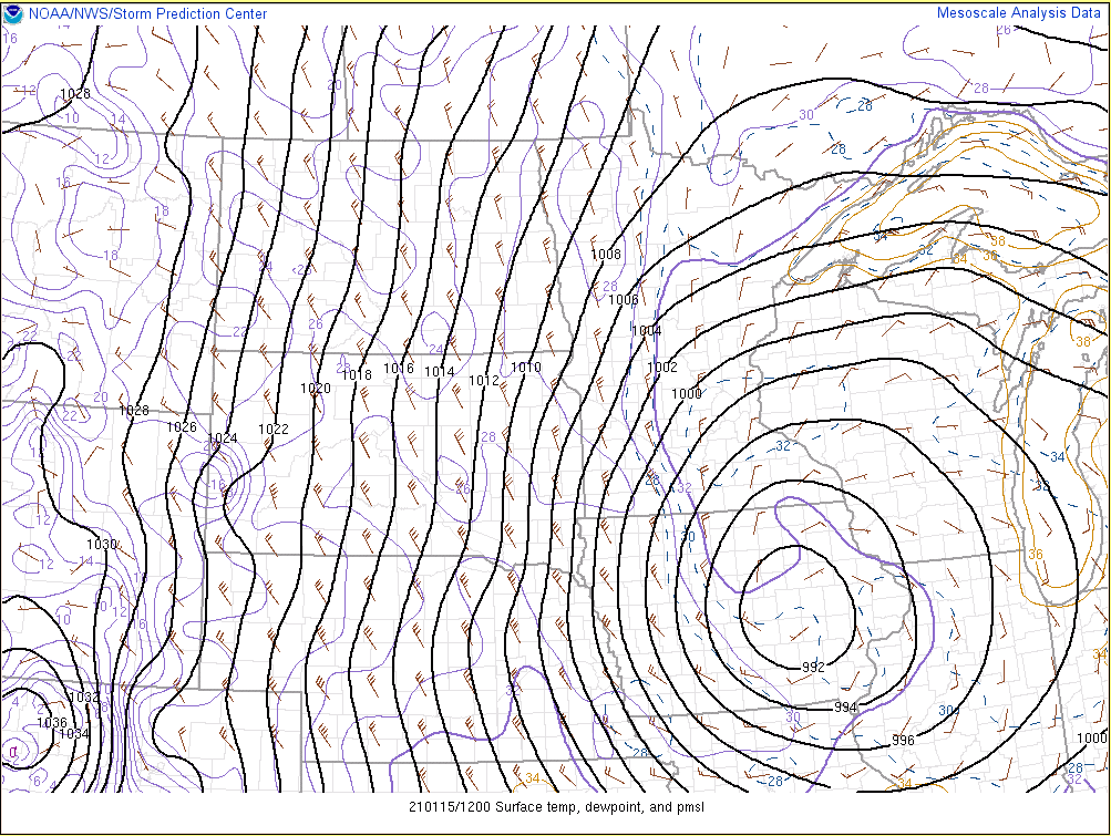 |
 |
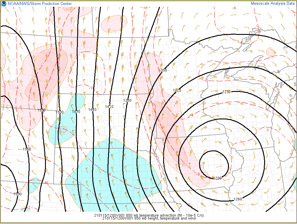 |
| Surface Temperatures/Winds/Pressure 12Z Fri 15 | 3 Hrly Temperature Change 12Z Fri 15 | 850 MB Warm Air Advection 12Z Fri 15 |
 |
Media use of NWS Web News Stories is encouraged! Please acknowledge the NWS as the source of any news information accessed from this site. |
|

